Caribbean — Oceanography and Bathymetry
Table of Contents
Bathymetry
Bathymetry Seas and Basins
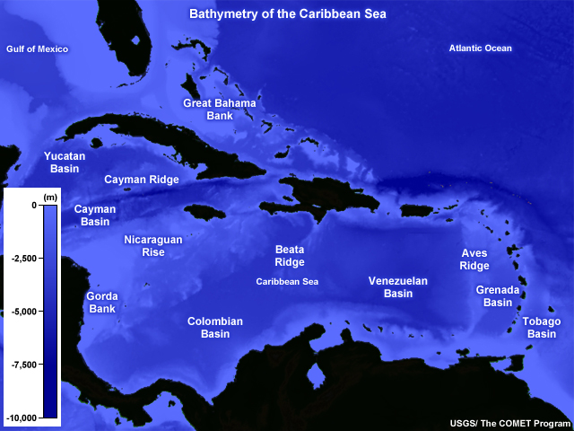
In the northwest Caribbean are the Yucatan and Cayman Basins. The Colombian and Venezuelan Basins occupy most of the central Caribbean with the smaller and shallower Grenada Basin and Tobago Basins in the east.
The Yucatan and Cayman Basins are partially separated by the narrow and steep Cayman Ridge. The Beata Ridge runs north-south between the Venezuelan and Colombian Basins, while the Aves Ridge separates the Grenada Basin from the Venezuelan Basin.
The Gorda Bank is the shallow region connecting Central America and the Nicaraguan Rise. The Great Bahama Bank includes the islands of the Bahamas and separates Cuba from the Atlantic Ocean.
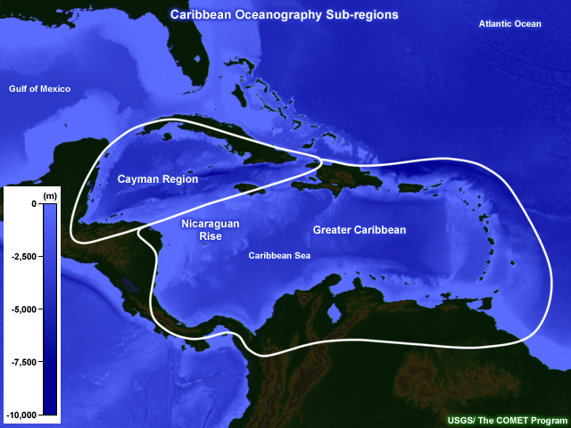
The Nicaraguan Rise, a triangular-shaped ridge that extends from Central America towards Hispaniola, separates the northwest Caribbean from the rest of the sea. The Nicaraguan Rise serves as a natural break for separating the oceanography of the Cayman region and the Greater Caribbean region.
Bathymetry Prominent Trenches and Straits
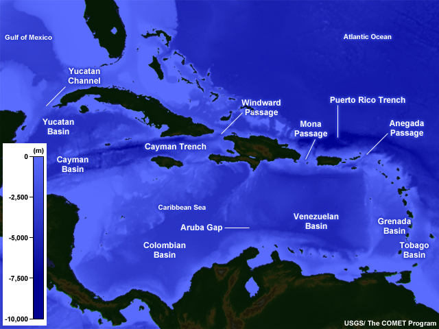
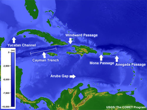
The deepest part of the Caribbean Sea is the Cayman Trench (the Barlett Deep) between Cuba and Jamaica. It is about 7,686 m (25,216 ft) below sea level. On the outer edge of the northeast Caribbean is the Puerto Rico Trench, the deepest part of the Atlantic Ocean at 8,648 m (28,374 ft) below sea level.
The Yucatan Channel, between Mexico and Cuba, connects the Gulf of Mexico and the Caribbean Sea. Between Cuba and Haiti (the western nation on the island of Hispaniola) is the Windward Passage. The Mona Passage separates the Dominican Republic (the eastern nation on Hispaniola) and Puerto Rico. Farthest east is the Anegada Passage, which separates the Virgin Islands from the Lesser Antilles. Between the Venezuela Basin and the Colombian Basin is the Aruba Gap, which has depths greater than 4,000 m (13,000 ft).
Cayman Region
The oceanography of the northwestern Caribbean Sea, referred to here as the Cayman Region, is distinguished from the rest of the sea because of its separation by the Nicaraguan Rise.
Cayman Mean Sea Surface
Cayman » Mean Sea Surface Sea Surface Temperature (SST)
For most of the northwest Caribbean, the SST maximum occurs during autumn, lagging the land surface temperature maximum that happens in the summer. During both summer and autumn, the highest SSTs are in the northern part of the region, the reverse of the expected pattern of warmer low latitudes and cooler higher latitudes. The expected pattern of warmer waters to the south occurs during winter and spring. During both winter and spring, an axis of higher SST values points towards the Yucatan Channel in the northwest, evidence of the role of the Caribbean Current and the Yucatan Current in transporting warm water northward.
The meridional SST gradient over open water is highest during summer. The reverse gradient of cooler SSTs to the south is caused by the wind maximum that develops due to strong sea level pressure gradients over the southern Caribbean. SST gradients are fairly weak across the region except in the shallow banks of the southern coast of Cuba during winter. The orientation of these strong gradients suggests that they are related to frontal passages that bring cool northerly and northwesterly winds and coastal upwelling to these areas.
Cayman » Mean Sea Surface Surface Salinity
Surface salinity is higher in the northwest Caribbean than in the rest of the Caribbean. Gradients are weak and the annual range is very small. Unlike the Gulf of Mexico and the southern Caribbean, this region has relatively little fresh water discharge. Here, seasonal trends are related to the large-scale atmospheric circulation. The movement of high salinity areas is associated with the migration of the subtropical ridges, regions where evaporation exceeds precipitation, which increases salinity. A trough points towards the Yucatan Channel, indicating northward transport of water with lower salinity by the Caribbean Current and the Yucatan Current.
Cayman Currents
The northwest Caribbean is where the Caribbean Current links to the Yucatan Current, which transports water from the Caribbean into the Gulf of Mexico. The Caribbean Current makes a sharp turn to the west across the Cayman Basin. Most of the flow from the southern Caribbean is channeled through a trough to the southwest of Jamaica since little flows over the Nicaraguan Rise. The flow in the Yucatan Current is in a narrow swath that hugs the Yucatan Peninsula. In this region, the flow through the Yucatan Channel is about twice as strong as the Caribbean Current in all seasons. The Caribbean Current flow across the Cayman region is strongest during summer.
Cayman Tides
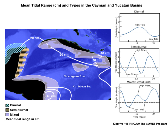
The mean tidal range in the northwest Caribbean (north of the Nicaraguan Rise) is very small, mostly 10-20 cm (0.3-0.7 ft). The Windward Passage region has a range of 30-40 cm (1-1.3 ft). The tide is mixed semi-diurnal. With such a small range, the tidal response can be masked by local and synoptic meteorological and oceanographic conditions.
Greater Caribbean
Greater Caribbean Mean Sea Surface
Greater Caribbean » Mean Sea Surface Sea Surface Temperature (SST)
In general, SSTs are higher towards the western parts of the Caribbean, a response to the prevailing winds and surface currents moving from east to west. In all seasons, a local maximum is observed over the southwestern Caribbean, off the coast of Colombia and Panama. For the Greater Caribbean Sea (south of the Greater Antilles), SSTs are highest in the summer. During this period, relatively low SSTs are in the extreme southern Caribbean, the reverse of the expected pattern of warmer low latitudes and cooler higher latitudes. During both winter and spring, an axis of higher SSTs is oriented southeast to northwest across the Caribbean, indicating the transport of warm water by the Caribbean Current. Relatively lower SSTs found in pockets of the South American coast may be related to local wind maxima that cause cool upwelling.
The wind maximum, which develops due to strong sea level pressure gradients over the southern Caribbean, causes the reverse meridional gradient of cooler SSTs to the south during summer.
Greater Caribbean » Mean Sea Surface Surface Salinity
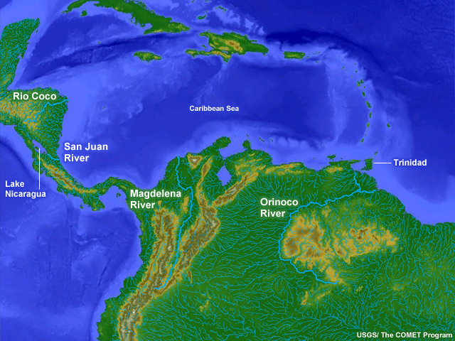
This water is a mixture of freshwater discharge from South America, mostly the Amazon and Orinoco Rivers, and North Atlantic surface waters. The influence of the freshwater run-off is seen in the seasonal cycle of salinity with lowest values during autumn, a response to the rainy season peaks over the northern South America.
This water is a mixture of freshwater discharge from South America, mostly the Amazon and Orinoco Rivers, and North Atlantic surface waters. The influence of the freshwater run-off is seen in the seasonal cycle of salinity with lowest values during autumn, a response to the rainy season peaks over the northern South America.
Greater Caribbean Currents
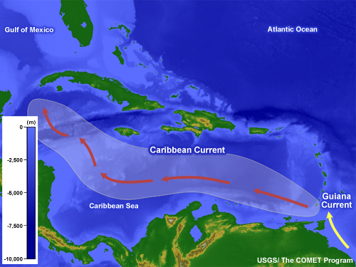
The major circulations of the Greater Caribbean Sea are the Caribbean Current and the Colombia-Panama Gyre. The Caribbean Current transports water westward then northwestward to the Yucatan Current, which flows into the Gulf of Mexico. The Colombia-Panama Gyre is a counter-clockwise circulation off-shore of southern Central America and northern Colombia.
The Caribbean Current is fed by the equatorial Atlantic Ocean via the North Equatorial, North Brazil, and Guiana Currents. The Guiana Current, which is significantly modulated by freshwater discharges from the Amazon and Orinoco Rivers, flows along the northern coast of South America into the Caribbean. Water flows into the Caribbean Sea mostly through the Grenada, St. Vincent, and St. Lucia Passages in the southeastern Caribbean. Flow from the southern Caribbean enters the northwest Caribbean through a channel southwest of Jamaica, not over the Nicaraguan Rise.
The strongest flow in the greater Caribbean Sea is in the Caribbean Current over the southern third of the sea. The highest surface speeds can reach 70 cm s-1 (2 ft s-1) along the coasts of Venezuela, Aruba, and the Netherland Antilles. Strong currents also occur along the coasts of Panama and Colombia. The Caribbean Current is broadest over the southwestern Caribbean where it has no geographical boundaries.
Greater Caribbean Tides
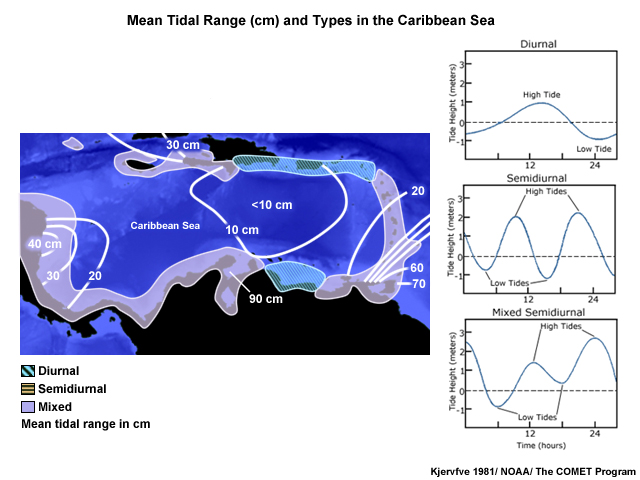
For a broad region of the Caribbean Sea, south of Hispaniola and Puerto Rico, the tidal range is less than 10 cm (0.3 ft). Ranges greater than 40 cm (1.3 ft), are found along the Nicaraguan shelf and the extreme southeastern Caribbean Sea. In the Gulf of Venezuela, where the tide has access to Lake Maracaibo, the mean range is 90 cm (~3 ft). Because the tidal range is generally so small, the tidal response can be masked by local and synoptic meteorological and oceanographic conditions.
The tide is primarily mixed semi-diurnal or mixed diurnal but a sub-region south of the Dominican Republican and Puerto Rico has a diurnal tide.
Questions Questions
Questions Question 1
Below is the properly labeled image:
Questions Question 2
Below is the properly labeled image:
Questions Question 3
In general, it can be said of mean salinity in the Caribbean Sea that: (Choose all that apply.)
The correct answers are c and d.
Salinity is lowest and gradients are strongest in the southeastern Caribbean, areas that receive large fresh water discharge from the Orinoco. It is generally highest in the northern Caribbean, the regions with the smallest annual range in salinity.
Questions Question 4
The highest SSTs in the Caribbean Sea are found _____. (Choose all that apply.)
The correct answers are c and d.
The highest SSTs are found in the northern Caribbean during summer. Relatively low SSTs are in the extreme southern Caribbean. A local maximum in SSTs is found near the Caribbean coast of Panama and Colombia during all seasons; warm surface waters pile up in that area because of the prevailing winds.
Questions Question 5
The Caribbean Current _____. (Choose all that apply.)
The correct answers are a and d.
The Caribbean Current is broadest over the southwestern Caribbean where it has no geographical boundaries. It is responsible for the northward transport of surface water that has low salinity because of discharge from rivers in northern South American.
Questions Question 6
Choose the correct description of mean tides in the Caribbean. (Choose all that apply.)
The correct answers are a, c, d, and e.
For most of the Caribbean Sea, tidal ranges are less than 20 cm. Tidal ranges greater than 40 cm are found along the Nicaraguan shelf and the extreme southeastern Caribbean Sea. In the Gulf of Venezuela, where the tide has access to Lake Maracaibo, the mean range is 90 cm.