Gulf of Mexico — Oceanography and Bathymetry
Table of Contents
Bathymetry

The Gulf of Mexico covers more than 1.6 million km² (617,000 mi²)—approximately 1,770 km (1,100 mi) at its widest point and 1,290 km (800 mi) at its longest point. The major bathymetric features of the Gulf of Mexico include the Bay of Campeche, the Campeche Bank, the West Florida Shelf, and the Sigsbee Deep with connections to the Caribbean Sea through the Yucatan Channel and to the Atlantic Ocean through the Florida Strait. The deepest part of the Gulf of Mexico is the Sigsbee Deep in the southwest, at about 4,000 m (13,000 ft) deep.
Mean Sea Surface
Mean Sea Surface Sea Surface Temperature (SST)
The SST is controlled mainly by the solar heating cycle, so the mean SST declines from equator to poles and the range increases. Consequently, the most dramatic seasonal change occurs in the northern Gulf of Mexico. While SST isotherms are primarily zonal, relatively strong gradients occur along the coastal boundaries of the Gulf of Mexico, consistent with the differential heating between land and ocean and between deep and shallow waters. For instance, during winter, SSTs over the shallow Florida coast are relatively low compared with SSTs at the same latitude in the open water. SSTs are highest during summer in response to solar heating and flow of warm waters from the Caribbean. Pockets of relatively cooler SSTs occur along the Campeche Bank, the result of coastal upwelling with flow away from the coast. During summer, SST is not useful for defining surface current structure as the temperature gradients all but disappear over most of the Gulf. However, sharp SST gradients around Florida and the Gulf of Mexico during winter and spring are useful for defining current structure.
Mean Sea Surface Salinity
Salinity is strongly influenced by river outflow (which is seasonal and episodic), evaporation, and freshening from precipitation. As expected, salinity is lowest and gradients are strongest in the northern Gulf, which experiences large fresh water discharge from the Mississippi. Correspondingly, the southern Gulf of Mexico has a very small annual salinity range and weak gradients. During winter, a broad area of relatively high salinity spreads across the Gulf, except for narrow strips of steep gradients along the estuaries of the Mississippi in the northern Gulf and the Grijalva and Usumacinta in the south. Salinity is at its lowest over the Gulf of Mexico during summer when river discharge is highest, as expected from seasonal rainfall and snow melt in the north.
Major Currents
Major currents in the Gulf of Mexico are the Yucatan Current, the Florida Current, and the Loop Current, which links them. The Yucatan Current flows north from the Caribbean through the Yucatan Channel, and the Florida Current flows east through the Florida Straits to the Gulf Stream in the Atlantic.
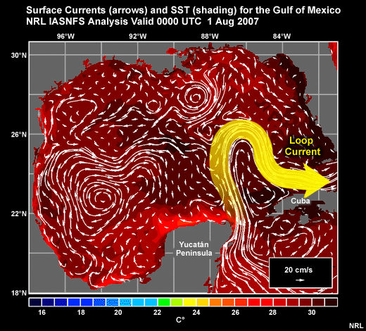
The Loop Current has a well-known omega-shaped flow pattern. It is fed by the Caribbean Current and the Yucatan Current; it transports surface waters from the tropics into the Gulf of Mexico; and it feeds the Florida Current, which helps to transport significant amounts of heat poleward when it flows into the Gulf Stream.
The Loop Current flows along the boundaries of a warmer and slightly fresher body of water. Its flow is approximately geostrophic, i.e., along a line of constant height (usually measured by satellite altimetry). Its location is constrained by the bathymetry of the Gulf with entrance in the deep notches of the Yucatan Channel and exit via the more shallow Florida Straits.

The Loop Current takes on distinct flows; sometimes flowing directly to the Florida Straits via the north coast of Cuba and other times flowing to the Mississippi Delta before looping back southward.
The Loop Current ring usually forms around a warm-core eddy then drifts westward at about 2-5 km/day. The deepest areas of warm water in the Gulf of Mexico are usually associated with the Loop Current and its warm-core rings.
On average, the primary circulation in the Western Gulf is a large anticyclone. In the south, a long-term mean cyclonic circulation occurs in the southern Bay of Campeche that is likely due to wind stress curl. Winds turn towards the southwest due to the presence of the high coastal Sierra Madres and are steered through the Chivela Pass in the Isthmus of Tehuantepec. The figure shows a period when a strong cyclonic circulation was present, with an anticyclone to its north. Between the cyclonic/anticyclonic pair, flow accelerates westward to form a weak, mostly northward, boundary current along the coastline. To see animations of currents in the Gulf of Mexico during the most recent 30 days and 12 months, visit the Navy's Intra-Americas Sea web page, http://www7320.nrlssc.navy.mil/global_nlom32/ias.html, and click on the Speed/Currents Nowcast.
Tides

The Gulf of Mexico experiences small mean tidal ranges, about 40-90 cm (1.3-3 ft). Most of the Gulf experiences a diurnal tide. A few places in the northwest and southeast Gulf experience a combination of diurnal and semidiurnal tides.
Questions
Questions Question 1
Below is the properly labeled image:

Questions Question 2
Below is the properly labeled image:

Questions Question 3
Tides in the Gulf of Mexico generally exceed 100 cm (just over 3 ft).
The correct answer is False.
Tides in the Gulf of Mexico range from about 40 to 90 cm (1.3-3.0 ft).
Questions Question 4
In general, salinity is highest in the Gulf of Mexico during (Choose the best answer.)
The correct answer is d.