Overview — Climatology
Table of Contents
Large-scale Circulations
Large-scale Circulations Jet Streams


The location, intensity, and patterns of jet streams in the upper troposphere strongly influence the local weather. The Gulf of Mexico and the Caribbean Sea are affected by two major jet streams, the Polar Front Jet, commonly known as the Polar Jet, and the Subtropical Jet.
Large-scale Circulations » Jet Streams The Polar Jet

The polar front jet forms in the region of strong temperature gradients between cold, polar air and warmer air masses. Mean storm tracks follow the position of the polar jet. The jet is strongest during winter when the polar air masses expand towards the equator and when there is greater temperature contrast between the cold air and the warm sub-tropical and tropical air, whose source is primarily oceanic.
The jet attains maximum intensity with a mean speed of about 35 m s-1 near 300 hPa and near the continental coast around 30°N, where temperature gradients are strong. The polar jet typically merges with the subtropical jet near the Gulf Coast and occasionally migrates to the Gulf of Mexico. During the spring, the jet weakens and its mean position shifts northward. By summer, the polar jet is over northern states and Canada and is at its minimum intensity. In autumn the jet strengthens and shifts southward.
Large-scale Circulations » Jet Streams The Subtropical Jet
The subtropical jet usually attains its highest speed near 200 hPa. It is nearly continuous during winter when it is strongest. It has a quasi-three wave pattern around the globe, and one of its maxima is over the southeastern U.S. where it usually merges with the polar jet. During summer, the subtropical jet becomes weak and intermittent. Its mean position shifts from 20°-35°N during winter to close to 40°N during summer. It flows poleward of an upper-level anticyclone that forms over the U.S./Mexico border, near 32°N, during July. By October, the anticyclone has shifted south to near 15°N, and the subtropical jet shifts southward and intensifies.
Large-scale Circulations Synoptic Patterns


Persistent high and low pressure areas occur across the globe but in generally consistent geographic locations. These semi-permanent pressure systems have a strong influence on local weather as they affect storm tracks, frontal positions, and seasonal monsoons. Over time, the centers of these systems shift, and they grow or shrink and change in intensity.
The area that encompasses the Gulf of Mexico and the Caribbean is affected primarily by the Bermuda-Azores High, Equatorial Trough, Sonora Low (during summer), and North American High (during winter).
Large-scale Circulations » Synoptic PatternsBermuda-Azores High
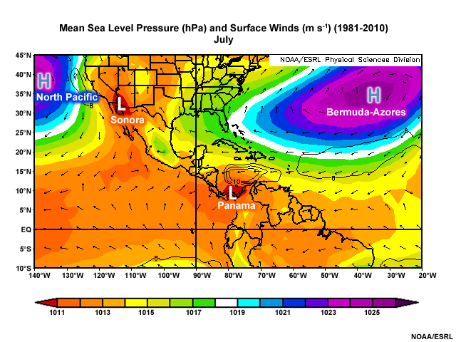
The Bermuda High is a subtropical high located over the Atlantic Ocean. At its center are light winds and almost no current, which presented problems for ships sailing from Europe to the Americas. During the summer, the Gulf of Mexico and the Caribbean Sea are dominated by the Bermuda-Azores High, which is at its westernmost position. Circulation around the high results in southeasterly winds over the Gulf and easterly winds over the Caribbean. The winds bring warm, moist air from the ocean onto the land. Hurricanes track around this high pressure circulation, so shifts in its location are critical to forecasting landfall in North America, the Caribbean, or Central America. During winter, the Bermuda-Azores High is farther east, which allows northerly winds and cooler weather to reach the Gulf and Caribbean. Mean surface winds are mainly northeasterly.
Large-scale Circulations » Synoptic PatternsEquatorial Trough


The Equatorial Trough is a quasi-continuous belt of low pressure between the subtropical highs of the Northern and Southern Hemispheres, sometimes referred to as the meteorological equator. The trough forms in response to surplus heating of the surface in the tropics and is marked by rising motion. Differential heating between land and ocean cause regional variations in its poleward migration. It reaches as far north as Belize in Central America and the southern Caribbean islands in the east. A local minimum, called the Panama Low, forms over the Panama-Colombia border. The Inter-tropical Convergence Zone (ITCZ) refers to the axis of confluence between the northeast and southeast trade winds. Actual convergence only happens along sections of that axis. Some meteorologists refer to the ITCZ only where there is deep convection as opposed to areas with shallow convection such as the Near Equatorial Trade Wind Convergence (NETWC) over the tropical East Pacific.
Large-scale Circulations » Synoptic PatternsNorth American High
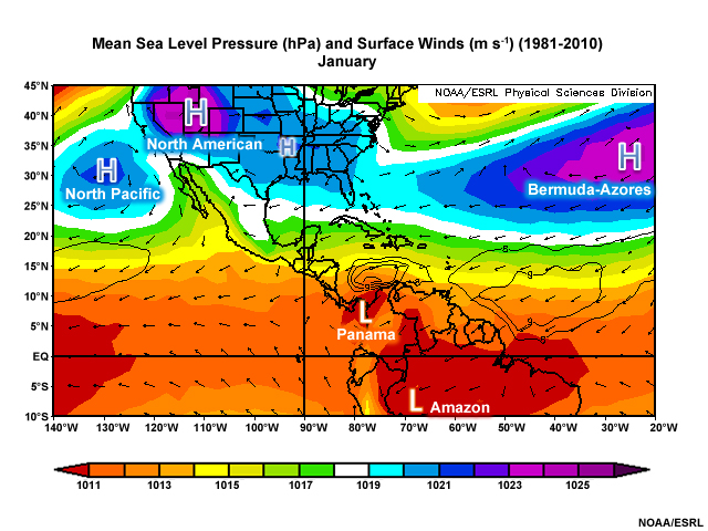
The North American High is a strong but shallow area of high pressure that forms as cold winter temperatures settle over North America. Variations in the extent and strength of this high pressure area strongly influences local weather in the Gulf and Caribbean. For example, extreme cold outbreaks are associated with southward migration of this high pressure area.
Large-scale Circulations » Synoptic PatternsSonora Low
The Sonora Low, also known as the Mexican monsoon low, is a thermal low pressure that forms during the Northern Hemispheric summer in response to the warming of northern Mexico and the southwestern U.S.. Part of the North American Monsoon system, this low pressure, draws most of its moisture from the tropical east Pacific, with some contribution from the Gulf of Mexico.
Large-scale Circulations Upper-level Wind & Circulations

Tropical Upper Tropospheric Troughs (TUTTs) are persistent summer-time phenomena that extend from the Atlantic into the Caribbean and Gulf of Mexico and produce clouds and precipitation. These upper-level lows are cold relative to their surroundings and usually do not extend below 500 hPa. TUTTs sometimes induce inverted troughs in the low-level easterlies, and they interact with easterly waves to form tropical cyclones. A prominent upper-level anticyclone is present over North America to the west of the TUTT.

During winter, a zone of confluence is present along the Gulf Coast, where the polar jet and subtropical jet typically merge, and a broad weak ridge extends across the region from South America.
Large-scale Circulations Madden-Julian Oscillation (MJO)

The Madden-Julian Oscillation or MJO is a 30-60 day coupled atmosphere-ocean oscillation in the tropics. The MJO is noticeable as large regions of enhanced and suppressed precipitation moving eastward across the tropics.

It is also tracked using anomalies of outgoing longwave radiation (OLR), 850 and 200 hPa winds, and velocity potential.

Although the MJO is most prominent over the Indian Ocean and Western Pacific Ocean, it modulates tropical cyclone activity; causes prolonged wet and dry periods across the southwestern Caribbean, Central America and the north coast of South America; and it modulates the North American Monsoon.
Large-scale Circulations Questions
Large-scale Circulations Question 1
Below is the properly labeled image:

Large-scale Circulations Question 2
Use the selection box to choose the answer that best completes the statement.
Large-scale Circulations Question 3
Use the selection box to choose the answer that best completes the statement.
Large-scale Circulations Question 4
Below is the properly labeled image:

Large-scale Circulations Question 5
Below is the properly labeled image:

Large-scale Circulations Question 6
Use the selection box to choose the answer that best completes the statement.
Large-scale Circulations Question 7
Use the selection box to choose the answer that best completes the statement.
Extratropical Cyclones
Extratropical Cyclones Polar Front

The Polar Front refers to the boundary between the cold air masses that surround the poles and the warmer air at midlatitudes. In North America, the polar front separates the continental polar air masses and the maritime tropical air masses of the Gulf of Mexico and the Caribbean. Waves form along the front as these air masses migrate from their regions of origin.

The polar front is most intense and farthest south in winter. It retreats northward during spring as the continent warms and temperatures moderate. It has no influence on summer weather in the Gulf and Caribbean as the Bermuda-Azores High becomes the dominant feature across the region. In autumn, as the surface cools and high pressure begins to dominate the continent, the polar front moves south and occasionally intrudes into the Gulf of Mexico once more.

On rare occasions polar air has reached as far as the northern coast of South America during surges (also termed cold air outbreaks) from both the Northern and Southern Hemispheres. During the passage of a surge from the north, the front weakens as the polar air masses are moderated by the warm tropical waters and surface air. Surges from the south occur east of the Andes and are moderated by the air over the Amazon Basin.
Extratropical Cyclones Midlatitude Cyclones
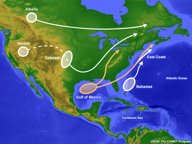
The Gulf of Mexico is a favorable region for midlatitude cyclones to form and intensify. Gulf of Mexico lows generally move towards the northeast. They can form anytime from autumn through spring but are usually strongest during winter when the temperature gradient between the cold, polar air and warm, maritime tropical air is very steep. When upper-level divergence associated with the polar jet and/or the subtropical jet becomes aligned with low-level convergence along the surface front, it enhances rising motion and leads to decreasing pressure and cyclone formation at the surface.
Extratropical Cyclones Questions
Extratropical Cyclones Question 1
The polar front over the Gulf of Mexico: (Choose all that apply.)
The correct answers are a and d.
Extratropical Cyclones Question 2
Use the selection box to choose the answer that best completes the statement.
Tropical Cyclones
Tropical Cyclones Ingredients for Genesis

Tropical cyclones form over warm waters from pre-existing weather disturbances. Some of these disturbances emerge every three or four days from the coast of Africa as "tropical waves," as seen here. They can also form from the trailing ends of cold fronts that move into the tropics and stall or, occasionally, from upper-level low pressure circulations that work their way down to the surface. Similarly, monsoon depressions and subtropical cyclones can provide disturbances from which, under appropriate thermodynamic conditions, a tropical cyclone could develop.

The process by which a tropical cyclone forms and subsequently strengthens into a hurricane depends on at least six conditions.
- Pre-existing disturbance with sufficient vorticity and convergence
- Ocean temperatures at least 26.5°C (80°F) to a depth of about 50 m (150 ft)
- Low values of vertical wind shear (less than about 10 m s-1 [20 kts / 23 mph])
- An atmosphere that cools with height such that it is potentially unstable to moist convection
- Sufficient moisture near the mid-troposphere to fuel the thunderstorms
- The disturbance must be at least 5° latitude away from the equator. However, in recent years a number of tropical cyclones have remained within 5° latitude of the equator, suggesting a need to relax this constraint.
With favorable conditions, a tropical depression will intensify into a tropical storm and then into a hurricane, as tropical cyclones are called in the Atlantic and Eastern Pacific Oceans.
| Saffir-Simpson Hurricane Category | Maximum Sustained Wind Speed (Max. 1-min average) |
Expected Level of damage |
||
|---|---|---|---|---|
| m s-1 | km h-1 | mph | ||
| 1 | 33-42 | 119-153 | 74-95 | Very dangerous winds will produce some damage |
| 2 | 43-49 | 154-177 | 96-110 | Extremely dangerous winds will cause extensive damage |
| 3* | 50-58 | 178-208 | 111-129 | Devastating damage will occur |
| 4* | 59-69 | 209-251 | 130-156 | Catastrophic damage will occur |
| 5* | 70+ | 252+ | 157+ | Catastrophic damage will occur |
NOAA/NHC
Hurricane intensity is categorized by wind speed. On this five-category scale, the Saffir-Simpson scale, the higher the category, the more damage a hurricane will inflict. But this depends on many factors, such as size of the area of highest winds, how slowly the hurricane moves, whether the hurricane moves across a relatively unpopulated, rural area or an urban one, or whether the building codes in the region are strong or lax.
Tropical Cyclones Hurricane Tracks

The zones where hurricanes form and the tracks they take are generally related to the time of year. Consequently, different areas have a greater risk during certain months, although patterns can vary considerably from year to year.


During the early (June-July) season, hurricane activity is typically quiet and what systems do form tend to occur in a fairly restricted area over the Gulf of Mexico or the westernmost Atlantic Ocean.


During the seasonal peak of August-September, decreased wind shear and increased water temperatures allow more hurricanes to form anywhere throughout the North Atlantic, Caribbean, and Gulf of Mexico.

October can see a substantial amount of hurricane activity from hurricanes that typically form in the western Caribbean or western Atlantic. These storms tend to have erratic tracks that often move quickly off to the northeast.

Finally, in the late hurricane season, activity dies down and the focus shifts to the western Atlantic.

Be aware that the climatology of tropical cyclones includes many deviations from the norm. For example, Hurricane Lenny, which formed in the central Caribbean Sea in November 1999, was the fifth category 4 hurricane that year. While climatology would suggest its most likely track would have been to the northeast, the storm went almost due east, damaging many ports on the western sides of the islands it passed nearby.
Tropical Cyclones Variability

The official hurricane season for the Atlantic Basin (the Atlantic Ocean, the Caribbean Sea, and the Gulf of Mexico) is from 1 June to 30 November. As seen in the graph, the season's peak is from mid-August to late October. However, tropical storms and hurricanes can and do occur outside of hurricane season.
Variations in factors that affect tropical cyclogenesis can lead to a clustering of the formation of events within a storm season. Some, such as the MJO, are tropics-wide phenomena, while others are regional modulators of genesis, such as the Saharan Air Layer (SAL) in the North Atlantic. There does not appear to be a link between storm activity early in the hurricane season and activity in the rest of the period, although over periods of many years hurricanes have cycles of greater and lesser activity.
Tropical Cyclones and Impacts in the North Atlantic Ocean
| Year | Number of tropical cyclones | Number of hurricanes | Number of major hurricanes | Deaths | Damage (U.S.$) |
|---|---|---|---|---|---|
| 1992 | 7 | 4 | 1 | 65 | $26.5 billion in the U.S. $250 million in the Bahamas |
| 2000 | 15 | 8 | 5 | 54 | $225 million in Belize $27 million in the U.S. (not including $950 million flood from pre-Leslie depression) $38.7 million in Mexico Damage costs were unavailable for other affected countries |
NOAA/HRD/NHC/CENAPRED
Before discussing interannual variability, it is important to understand the difference between annual cyclone activity (frequency and intensity) and the severity of cyclone impacts (landfall frequency, fatalities, and damage). For example, while the year 2000 had more than twice as many tropical cyclones as 1992, as well as more major hurricanes, the damage they inflicted was an order of magnitude less, primarily because Hurricane Andrew, which hit Florida in 1992, was one of the costliest U.S. hurricanes ever.

On interannual timescales, tropical cyclone variability can stem from global or regional patterns, such as the El Niño Southern Oscillation (ENSO), the Quasi-Biennial Oscillation (QBO) of the lower stratospheric wind, rainfall in the western Sahel, etc. ENSO affects tropical cyclone activity because of altered vertical wind shear and fluctuations in tropospheric and surface temperature during extreme warm phase ( El Niño) and cold phase (La Ni�a) events. ENSO is one of the dominant, multi-year influences on tropical cyclone activity, although, as mentioned previously, links between seasonal activity and landfall frequency, storm intensity, or storm impacts are tenuous. Although 1992 was part of a multi�year sustained warm event, it was the year that a Category 5 hurricane made landfall in Miami, Florida. Hurricane Andrew was the first storm�and a very late start�of a relatively quiet season, yet it was the most devastating storm to hit the U.S. mainland in almost twenty years.

Increased understanding of some of the interannual modulators of tropical cyclone activity has inspired seasonal forecasts of likely seasonal severity. While these forecasts have skill, they have largely failed to identify shifts in activity that may be associated with multidecadal variability or, possibly, with global climate change.
Tropical Cyclones Questions
Tropical Cyclones Question 1
Tropical cyclone formation requires strong winds at the upper levels of the atmosphere.
The correct answer is False.
Tropical Cyclones Question 2
Tropical cyclone formation requires ocean temperatures of at least 26.5°C (80°F).
The correct answer is True.
Tropical Cyclones Question 3
Tropical storms cannot form in the Caribbean or Gulf of Mexico in December.
The correct answer is False.
While tropical storms are most likely from June through November in this area, a few have occurred in December.
Tropical Cyclones Question 4
Could damage from a Category 5 hurricane be less than that from a Category 2 hurricane? Why or why not.
(Type your answer in the box, then click Done.)
Generally, the higher the category, the more damage a hurricane will inflict. But this depends on many factors, such as size of the area of highest winds, how slowly the hurricane moves, whether the hurricane crosses a relatively unpopulated, rural area or an urban one, or whether the building codes in the region are strong or lax.
Tropical Cyclones Question 5
Use the selection box to choose the answer that best completes the statement.