Forecaster Practice
Table of Contents
Working an Event
In the weather phenomena cases detailed in this training, we examined a variety of scenarios for which the National Weather Service provided weather forecasts and decision support to its aviation partners. The present case highlights the roles of forecasters in supporting the smooth operation of the NAS.
In the case well follow here, the potential for weather impacts was known ahead of time, but the exact locations and times of the impacts were more difficult to forecast. Still, working from the most up-to-date information and keeping close communication among the WFO, CWSU, ATCSCC meteorologists, and air traffic coordinators can help minimize disruptions to air traffic in the affected areas.
The Day Prior
As part of their strategic planning operations, CWSUs and the ATCSCC will look at the Storm Prediction Center (SPC) Convective Outlook to determine where weather threats might occur. Review the following Day 2 Convective Outlook for April 10 and decide where convective weather is most likely to occur.
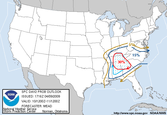
                     DAY 2 CONVECTIVE OUTLOOK
                     NWS STORM PREDICTION CENTER NORMAN OK
                     1216 PM CDT THU APR 09 2009

                     VALID 101200Z - 111200Z
                     TSTMS /SOME SEVERE/ ARE EXPECTED TO BE ONGOING FRIDAY MORNING WITHIN
                     ZONE OF DEEP ASCENT AHEAD OF SURFACE LOW OVER PARTS OF THE LOWER OH
                     AND LOWER MS VALLEYS…AS WELL AS WITHIN WAA REGIME FARTHER E ACROSS
                     PARTS OF ERN TN/AL/NRN GA.  THE FORMER ACTIVITY WILL LIKELY INCREASE
                     IN BOTH COVERAGE AND INTENSITY BY LATE MORNING/EARLY AFTERNOON
                     ALONG/AHEAD OF COLD FRONT FROM CNTRL KY/MIDDLE TN SWD INTO AL
                     AS STRONGER FORCING/HEIGHT FALLS ASSOCIATED WITH SECONDARY VORTICITY
                     MAXIMUM ACT ON DESTABILIZING AIR MASS.
Question
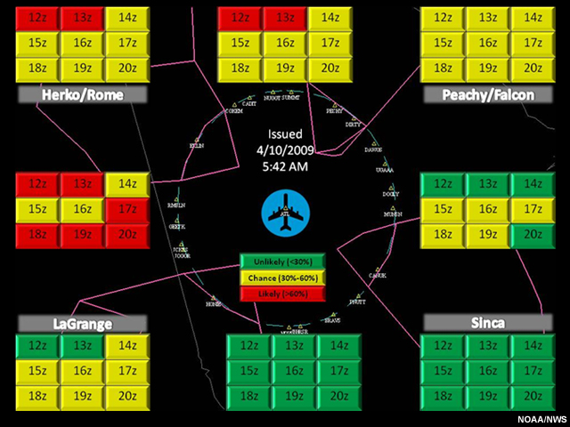
Based on the Day 2 Convective Outlook for April 10, where is convective weather most likely to occur? (Choose all that apply.)
The correct answers are a), b), and c).
Based on the Day 2 Convective Outlook for April 10, the highest likelihood of convective weather was for the southeast U.S., and specifically across areas of Alabama, Tennessee, and Georgia. In addition to CWSU forecasters, meteorologists at the ATCSCC are also monitoring this frontal line and alerting their FAA partners of the potential for impacts on flights in the southeastern U.S. the next day. When serious weather disruptions are expected, the FAA will increase staffing to deal with the increased traffic management load.
At the 7:00 p.m. EDT coordination call with ATCSCC, the ARTCCs, and the airlines, the possibility of convective weather during the next afternoon would be mentioned. Representatives from the airlines participate in these coordination calls with the FAA (ARTCCs, ATCSCC, select towers and TRACONs) every two hours to plan aviation operations. The calls help everyone get on the same page for future routes, airport acceptance rates, and any expected impacts. Although tactical decisions (0 to 2 hours) are occasionally discussed during the calls, the focus is on the short-term planning aspects of the operation (2 to 8 hours). The ATCSCC would ensure they were fully staffed to handle any traffic management issues, but plans would not be developed as they might be for a more certain event such as a snowstorm. By the next morning, ATCSCC, AWC, and the southeastern U.S. CWSUs and WFOs will be carefully monitoring any developing weather to develop more specific plans for the day.
Day of Event
On April 10, the Atlanta CWSU meteorologist began reviewing the current weather conditions to assess if the anticipated weather threats were unfolding. Such reviews often need to be done quickly. The CWSU forecaster must prepare a morning briefing for the TMU even as the early traffic pushes are already underway.
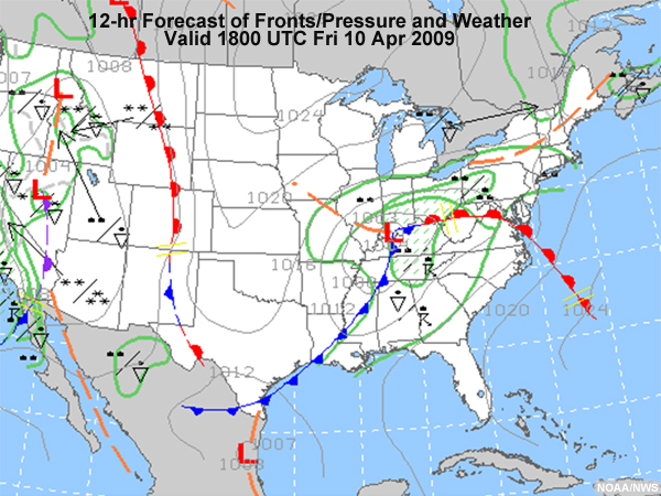
Day of Event – Identify the Threat
Review the graphical forecast for 18:00 UTC (2 p.m. EDT) 10 April and the Mesoscale discussion, then answer the question below.
     MESOSCALE DISCUSSION 0426
     NWS STORM PREDICTION CENTER NORMAN OK
     0704 AM CDT FRI APR 10 2009

     AREAS AFFECTED…NORTH GA INTO EXTREME WESTERN PORTIONS OF NC/SC

     CONCERNING…SEVERE POTENTIAL…WATCH UNLIKELY

     VALID 101204Z - 101330Z

     ISOLATED DAMAGING WIND/HAIL THREAT MAY CONTINUE OVER THE NEXT FEW
     HOURS MAINLY ACROSS FAR NORTHERN GA AND PERHAPS INTO THE EXTREME
     WESTERN PORTIONS OF NC/SC. A WATCH IS NOT EXPECTED AT THIS TIME.

     SMALL SCALE/75 MILE LONG MCS/BOW ECHO CONTINUES TO RACE
     EAST-NORTHEASTWARD AT AROUND 45 KT INTO NORTHWEST GA TOWARD THE I-75 CORRIDOR
     AS OF 12Z. THIS MCS HAS AN UPSTREAM HISTORY OF ISOLATED
     WIND DAMAGE/HAIL…AND A SIMILAR THREAT MAY CONTINUE OVER THE NEXT
     FEW HOURS PRIMARILY ACROSS THE NORTH GA AREAS NORTH OF I-85. AIDED
     BY A MID LEVEL IMPULSE…THIS MCS IS GENERALLY BEING FED VIA AN
     INCREASINGLY MOIST/UNSTABLE AIRMASS FROM THE SOUTHWEST. ORGANIZED
     NATURE OF THE MCS WILL CONTINUE TO SUPPORT A CONTINUED SEVERE RISK
     IN THE SHORT TERM…ALTHOUGH A PRE-MCS TREND FOR COOLING SURFACE
     TEMPERATURES IMPLIES THAT THIS SYSTEM MAY BECOME INCREASINGLY ROOTED ABOVE
     A COOL NEAR-SURFACE LAYER. WITH THE EXPECTATION THAT THE SEVERE THREAT WILL
     REMAIN FAIRLY ISOLATED THIS MORNING…A WATCH IS  NOT CURRENTLY ANTICIPATED.
Question
Based on the forecast, with whom should a CWSU forecaster coordinate prior to offering a briefing to the TMU? (Choose all that apply.)
The correct answer are b), d), and e).
After assessing how the weather event is shaping up, the CWSU meteorologist checks in with the WFO to go over their forecast discussion, the latest TAF, and other weather developments. The CWSU meteorologist will also view the current CCFP and do any necessary coordination with AWC. Items discussed among the forecasters include the onset and duration of the event, as well as the degree of certainty about the timing and the location of the expected weather hazard. NWSChat in conjunction with a phone call to the TAF forecaster provide a useful interface for this discussion.
Beginning in the early morning hours, the AWC meteorologists coordinate input for the current version of the CCFP. During convective weather season (from March 1 through October 30), Collaborative Convective Forecast Products are issued every two hours (from 0300 through 2100 Eastern time). These products are released by the AWC, but CWSUs have the opportunity to input their information about expected conditions and degrees of convection in their area. AWC also needs input about turbulence for any SIGMETs that may be issued. The CWSU will share any PIREPS of turbulence or other issues that will help advise AWC of the areas and altitudes affected.
Following the coordination with the WFO and AWC, the CWSU pulls all the weather information together and briefs the TMU about the incoming weather and its timing and location. If necessary, the briefing might also include TRACON and the tower.
Day of Event – Understand User Needs
Question 1
Based on the weather discussions and the current surface maps, what threats should you highlight in your briefing for the forecast area? (Choose all that apply.)
The correct answers are b, c), d), and e).
Today the main threat is thunderstorms, which brings the potential of turbulence, as well as wind shifts that could affect terminal operations. Microbursts and wind shear are additional threats.
Question 2
With convective activity anticipated, what would be the major concern for the FAA? (Choose all that apply.)
The correct answers are a) and c).
Rerouting traffic to different gates would be the major challenge. Thunderstorms can close off a gate and require flights to follow other arrival or departure routes. A thunderstorm over the airport could also temporarily suspend ground operations.
Day of Event – Communicate the Threat
Question 1
Based on your analysis of the weather situation, which of the following briefings contains the information you would offer to the TMU? (Choose the best answer.)
The correct answer is a).
The briefing includes possible time of onset of thunderstorms, changes in ceilings and visibilities as well as the potential of a second wave of thunderstorms later in the day. The briefing also identifies turbulence and icing hazards within the TRACON. The other two briefings don't properly address the potential for a second wave of thunderstorms by inaccurately stating the timing or severity of the threat.
Question 2
Based on the threats, should the CWSU meteorologist also offer a briefing to TRACON? (Choose the best answer.)
The correct answer is Yes.
Given the potential for thunderstorms, wind changes and turbulence, you will need to inform TRACON about these threats as well. CWSU personnel also provide briefings directly to TRACON and the Tower. Knowing about the anticipated timing of an event is particularly important for terminal operations. Switching takeoff/landing directions or delaying takeoffs and landing due to visibility restrictions can take time and further confound the flow of traffic in and out of an airport. Even short-lived events can significantly impact airspace operations.
In this case, in addition to the normal stand-up briefing to the TMU, the CWSU briefed the Atlanta TRACON at 7:00 a.m.
The following text represents the updated briefing issued by the CWSU at 7:00 a.m.: Expect the convective activity to weaken as it moves into the western reaches of the state. Should see some shower activity push into the Atlanta area by 14Z if not sooner. Otherwise…Expect MVFR CIGs to develop this morning…Mainly around the 025 range and prevail today. However…after this initial convective surge this morning… and the airmass re-charges ahead of the cold front later this afternoon…the CIG might increase into the low VFR range briefly by afternoon…but inclined to just hold onto MVFR for now. Still expect the greater TSTM threat at ATL to be in the late afternoon-early evening hours as current tafs suggest. Showers and TSTMs remain possible thru the evening. Hazards within TRACONs airspace: LGT-MOD turbulence AOB 100 and LGT-MOD icing AOA 120.
The CWSU meteorologist also noted which gates might be affected as well as the timing of the impacts.
Day of Event – Coordination Call
Every two hours, following the issuance of the updated CCFP, the ARTCC traffic coordinators participate in a Coordination Call with the ATCSCC (the Command Center). On these calls, the Command Center will brief the traffic coordinators at the different centers and at the airlines on any traffic management plans in place. The various centers can bring up any concerns and suggest additional plans based on expected conditions at their airports provided by their CWSUs.
Here is the 0900Z (5:00 a.m. EDT) CCFP, valid for 1100Z (7:00 a.m.) and 1500Z (11:00 a.m.).
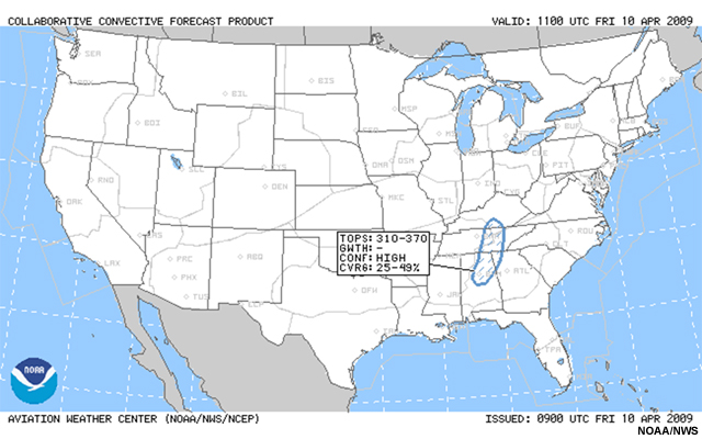
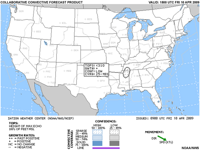
The first coordination call would occur at 1115Z, following the issuance of the 11Z CCFP. Here is a transcript of the discussion occurring on that call.
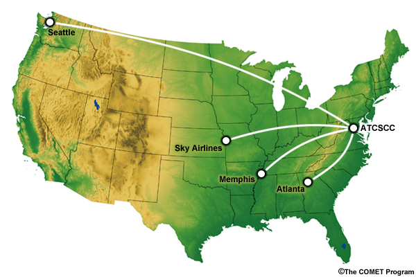
Coordination Call dialog:
Command Center: Good morning, this is the 1115Z coordination call. An area of thunderstorms is expected across parts of Tennessee, northern Alabama, and northern Georgia. This activity is in the CCFP through the 6 hour forecast. We will need to be keeping an eye on what develops today. Do any centers have anything to add to the plan at this time?
Seattle Center: This is Seattle Center. We are concerned about an earlier runway swap forecast by our CWSU today, by 18Z. We are already down a runway due to construction, so it would be worth mentioning the potential for a GDP for Seattle as the swap is forecast during a high volume period.
Command Center: We will add that to the plan. Does anyone else have anything to add to the plan?
Sky Airlines Representative: Sky Airlines here. Could we also revisit with Memphis or Atlanta as thunderstorm development is indicated in the CCFP over parts of the southeastern U.S. through 15Z? What are the anticipated impacts to the Q routes?
Command Center: Sure, Memphis, Atlanta? Input on the Q routes?
Memphis Center: Memphis believes Q routes will have limited availability for some periods between 1100Z and 1500Z due to the mentioned thunderstorm activity. We will handle any deviations to the northwest Atlanta gate tactically.
Atlanta Center: Atlanta Center, here. Agreed.
Command Center: Thank you Memphis, Atlanta, and Sky Airlines.
Day of Event – Anticipate the Impacts
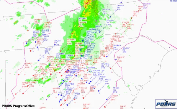
The line of thunderstorms moved across Tennessee and northern Georgia around 1348Z (9:48 a.m.). Based on the forecast and coordination efforts, flights arriving and departing Atlanta airspace were directed through openings in the convective line and no major issues or delays were observed. By 1700Z (1:00 p.m.), only a few residual storms remained in the area.
Here is the TAF amendment issued at 1923Z.
            TAF AMD KATL 091923Z 0919/1024 19013KT P6SM FEW050
                          FM100000 20007KT P6SM SCT060
                          FM100900 19010KT P6SM OVC015
                          FM101800 21015KT P6SM OVC035
                          FM102300 23010KT 6SM -TSRA BR SCT025 OVC040CB=
Question 1
Based on the amended TAF, would you expect additional thunderstorm development in the 1900-2100Z timeframe? (Choose the best answer.)
The correct answer is a).
The TAF includes thunderstorms with rain beginning at 2300Z but does not address the potential for earlier activity. At ~1900Z (3 p.m.), an additional line of thunderstorms had developed and moved southeast into northern Georgia. This line of thunderstorms continued to track southeastward through the Atlanta airspace.
Question 2
What impacts might this second line have on aviation operations? (Choose all that apply.)
The correct answers are a), b), and d).
At ~1900Z, an additional line of thunderstorms is observed moving southeast into northern Georgia. As the system continued to move into northern Georgia, it closed all north gates into and out of the Atlanta International Airport. A number of incoming flights to the Atlanta airport went into holding patterns, some for fairly significant time periods. The storms moved directly over the airport, limiting the ability of planes to land for approximately 90 minutes. Once the weather at the airport cleared, traffic coordinators landed the waiting arrival flights as quickly as they could.
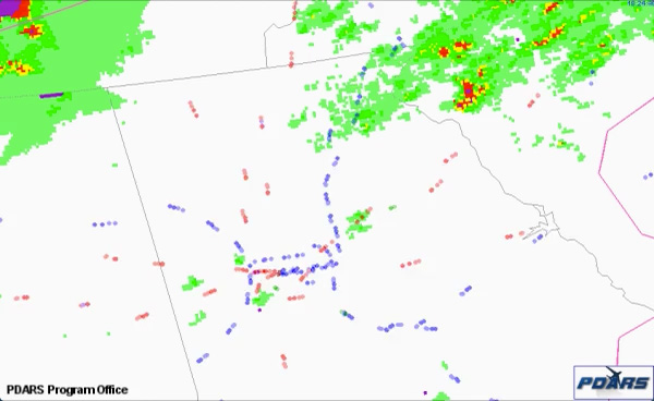
This animation begins at 1829Z as a line of thunderstorms moves into the Atlanta airspace from the northwest. Traffic to or from the northwest is directed through other gates to avoid this weather. During the 2100Z hour, the storm system is nearing Atlanta approach and some flights are forced into holding patterns or diversions. At 2300Z, some flights are still departing Atlanta International Airport, but the majority of operations are focused on landing the arriving flights. During the 0000Z hour, a number of flights can be seen approaching the northwest gates for Atlanta International Airport. Unfortunately, the storm system has been slow to move out and these flights are put into a holding pattern. Once the system moves past the airport, arrival and departure operations pick up again, and the remaining incoming traffic is landed as quickly as possible.
At 0234Z (10:34 p.m.), the CWSU provided this briefing to the Atlanta TRACON: "The trailing edge of convection is now just south and east of Hartsfield. Behind the remaining convection…a cold front will pass through Atlanta by 03Z. This will shift to the winds to the west-northwest at 12-14kts across north GA. VFR ceilings will lower to LVFR…then briefly MVFR as the front passes. Otherwise…no significant hazards are expected…outside of the convection."
As the night goes on, the number of inbound flights dwindles substantially, and demand at the airport finally subsides.
Key Points and Summary
Clearly, weather can significantly affect NAS operations. It can affect air traffic anywhere, and on any day. The number of flight delays and cancellations due to weather can be significant, because a disruption at one location can propagate through the entire system, affecting flights and airports across the country.
As you observed by working through the cases, communication of weather information also has an impact. In the Atlanta event, two rounds of thunderstorms activity affected the Atlanta airspace. In the first round, planning allowed operations to proceed efficiently despite the weather. The second round of storms had a greater areal coverage and much more significant effects on airspace operations. As the storms passed over the Atlanta International Airport, many flights were forced to hold in the air before landing. Every weather situation will be different, but in all cases, the more information you can provide to aviation partners ahead of time, the better their planning can proceed. In the Chicago snowstorm event when visibilities were expected to be below minimums, airlines proactively cancelled flights based on the TAF and consultation with forecasters about their confidence in the values.
Rick Curtis reemphasizes the importance of expressing forecast confidence to your decision-making airline partners.

Rick Curtis, Southwest Airlines
Click the play button to start the audio.
Rick Curtis, Southwest Airlines: "…if you can change one thing, I think having some kind of a confidence factor would be the thing that is the most needed because, again, it's not so much what you're saying, it's your degree of confidence of how much that is going to come true or not in order to make the decision. Because you can have a TAF and there's various ways, in most cases, to get around a TAF that put you below minimum where you carry additional alternates; different airlines have different thresholds for what alternates are required from a fuel standpoint. So, there are some ways, some latitude, not hundred percent but there are some latitudes [sic] around a TAF. However, the confidence values are the thing that we really struggle with."
"Theres a fair amount of changing that needs to go on in the community to be able to understand and work with a forecast in that format. That's really where we need to go. It takes the decision off the forecaster and it puts it back into where it should be which is the person that has all the informationnot just weather, there could be traffic, there could be station concerns of some sort, there could be a lot of different things that the weather forecaster doesn't know about. But, it needs to go back to the decision-maker that's actually operating the flight and not just the weather forecaster."
The support of the National Weather Service helps the FAA plan operations in ways that ensure safety and minimize disruptions. Timely and consistent weather information is critical to decision making within the National Airspace System. A number of avenues are in place to facilitate this communication during both routine and high impact events. This timeliness is particularly important. In many cases, changes to airspace plans do not occur until very close to the onset of the event, so that operations can proceed normally for as long as possible.
In this lesson, you learned about the programs in place to manage traffic within the NAS, as well as how weather affects these programs. You explored examples illustrating how the CWSUs, AWC, ATCSCC, and WFOs provide weather support for FAA decision makers and followed the case studies to observe how weather affects the NAS. Through the case studies, you observed the key elements for getting the most useful information to your users, by identifying and communicating the threat, understanding user needs, and anticipating the impacts. Lastly, you were able to practice techniques for including this information in the weather forecasts you produce for the aviation community.
Now that you have completed the lesson content, please test your knowledge through the online quiz. You can also submit a survey providing feedback about the usefulness of the training.