San Francisco Fog
Table of Contents
Introduction
Sometimes weather events develop very quickly and the impacts to aviation operations are immediate. If the event affects an airport at a peak time, traffic managers will have their hands full dealing with the situation to accommodate flights as quickly as possible.
When these unexpected weather events occur, close collaboration among the CWSU and WFO can ensure that the most up-to-date information is being passed along to the traffic managers who need it. Along with having a good handle on the weather threat involved, forecasters must understand the aviation users needs as well as the types of impacts anticipated from the weather situation. In this case, well examine a fast-onset event that caused major disruptions for multiple large airports and look at the Traffic Management Initiatives needed to address the situation.
Identify and Communicate the Threat
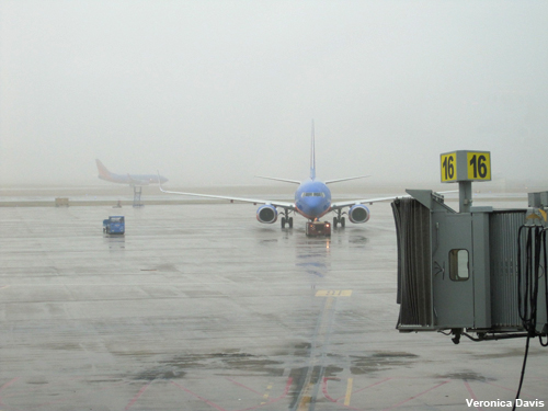
In the early morning of December 27, 2010, all looked good at the Monterey, California Weather Forecast Office. At 5:00 a.m., the forecaster on duty coordinated with the ZOA CWSU meteorologist to look at visibilities and other weather conditions through the morning hours. Recent satellite images indicated the presence of stratus about 10 nm from San Francisco International Airport. The TAF issued at 3:30 a.m. local time indicated the likelihood of scattered and broken clouds throughout the day.
                     KSFO 271126Z 2712/2818 21003KT P6SM FEW025 SCT050
                        FM271400 07003KT P6SM SCT100
                        FM272300 30008KT P6SM BKN100
                        FM280800 09003KT P6SM BKN100=
Question 1
Based on the forecast, what do you think will be the main concern for the FAA and airlines? (Choose the best answer.)
The correct answer is a).
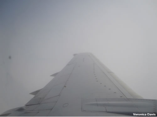
The FAA and airlines will be planning for low-level clouds over and in the vicinity of the airport—a concern but not something that is unusual for SFO. In these cases, traffic coordinators will most likely proceed with their regular plans for the day as long as the clouds do not impact the approach gates. Shortly after 14Z (6:00 a.m.), low clouds moved over the airport and fog substantially reduced runway visibilities at SFO.
The weather situation on this day was unusual in its evolution and required close cooperation between the CWSU and the WFO meteorologists. After conferring with the CWSU, the WFO meteorologist amended the TAF.
                     KSFO 271421Z 2714/2818 21003KT P6SM BKN015
                        FM271800 36003KT P6SM FEW015 SCT100
                        FM272300 30008KT P6SM BKN100
                        FM280800 09003KT P6SM BKN100=
Question 2
Review the following METARs from the airport and answer the question below. (Choose the best answer.)
KSFO 271705Z 01003KT 1/4SM R28R/0800V1800FT FG W001 09/08 A3035 A02
KSFO 271656Z 01003KT M1/4SM R28R/0500V0800FT FG W001 08/08 A3036 A02 SLP279 T00830078
KSFO 271607Z 00000KT 1/4SM R28R/0400V0500FT FG W001 08/08 A3035 A02
KSFO 271556Z 00000KT M1/4SM R28R/0500V0600FT FG W001 09/08 A3036 A02 SLP276 T00890083
KSFO 271544Z 00000KT M1/4SM R28R/0700V0800FT FG W001 09/08 A3035 A02
KSFO 271456Z 33003KT 1/4SM R28R/1200V1800FT FG W001 09/09 A3034 A02 SLP273 T00940089 55000
KSFO 271451Z 35003KT 1/4SM R28R/1200V1600FT FG W001 09/09 A3034 A02
Would the deteriorating conditions require another amendment?
The correct answer is b).
The conditions are worsening rapidly and require another amendment. Proactive amendments when the weather conditions warrant it are crucial to the users of weather products. Note that the RVRs dropped from 1200-1600 feet at 1451Z (6:15 a.m. PST) to below 700 feet through 1705Z (9:05 a.m. PST). These conditions prevented CAT II equipped aircraft from landing and only eight landings were completed between 7 and 8 a.m.; and two in the hour between 8 and 9 a.m.
The TAF was amended again at 1516Z (7:16 a.m.).
                KSFO 271516Z 2715/2818 33003KT 1/4SM FG VV001
                     TEMPO 2717/2718 4SM BR SCT001
                   FM271800 36003KT P6SM FEW015 SCT100
                   FM272300 30008KT P6SM BKN100
                   FM280800 09003KT P6SM BKN100=
Whenever conditions are below minimums, updating any forecast items and discussions (both from the WFO and the CWSU) is good practice. These updates help maintain consistency across all products and ensure that the aviation community is up to date with the latest information.
At 10:00 a.m. an updated Aviation Forecast Discussion was issued.
                     .AVIATION...AS OF 10:00 AM PST MONDAY...AREAS OF DENSE FOG
                     CONTINUE OVER THE SAN FRANCISCO BAY AREA THIS MORNING.
                     OTHERWISE...A FEW HIGH CLOUDS ARE FILTERING THROUGH THE SKY.
                     SATELLITE IMAGERY INDICATES THE FOG IS BEGINNING TO BREAK UP
                     ALONG WITH OBSERVATIONS REVEALING HIGHER VISIBILITIES.
                     THEREFORE...EXPECT VFR CONDITIONS BY 20Z.
Question 3
Given the original forecast and subsequent weather evolution, what coordination efforts should the CWSU forecaster initiate? (Choose all that apply.)
The correct answers are a) and b).
This challenging forecast situation requires that all lines of communication with aviation users remain open until the weather impacts diminish. The ARTCC and TRACON traffic managers would initiate a conference call with ATCSCC to quickly get a plan in place.
Understand User Needs
Question
Fog has begun disrupting visibility and inhibiting landings at San Francisco International Airport. What actions would traffic managers most likely initiate for flights already en route to the airport? (Choose the best answer.)
The correct answer is b).
Based on the weather products and rapidly developing fog, traffic managers will need to work with ATCSCC and the airlines to divert them to alternate airports and to delay some of the incoming traffic. Issuing reroutes on the fly increases the workload of controllers and TMCs significantly more than initiating standard playbook routes. In this case, a Ground Delay Program to limit traffic to SFO was in place by 1446Z, within 25-minutes of the TAF amendment. The consequences of traffic management actions will vary greatly, depending on how well the weather was anticipated. The best actions are those made in advance of, rather than in response to, the weather at hand. In this situation, the fog developed very rapidly, requiring quick coordination, and a forecast update outside the regular schedule.
Anticipate the Impacts
The fog dropped the visibility at San Francisco International Airport below minimums.
Question 1
What impacts would you expect from this event? (Choose all that apply.)
The correct answers are a), b), and d).
The impacts included numerous diversions (~25-30) to alternate airports at San Jose, Reno, and other airports. Four 757s were diverted to Monterey. An inbound 747 aircraft from the Far East declared a fuel emergency and made an emergency landing at Los Angeles International Airport after not being able to reach SFO. Ground Stops were in place for SFO and nearby Oakland International Airport due to the weather and excess airport demand. The reductions in visibility closed San Francisco International Airport for part of the morning and landing capacity was restricted for the rest of the day.
Question 2
What other impacts on the NAS might you anticipate? (Choose all that apply.)
The correct answers are b) and c).
Dozens of inbound flights to SFO were diverted to San Jose, Monterey, Reno, and Oakland. The unexpected demand caused capacity issues at both Oakland and San Jose, especially as Oakland also began to experience decreased RVRs. Because of the demand, a Ground Stop was put in place for Oakland. A Ground Stop to San Jose was also implemented as ramp/gate space at that airport began running out. Nationwide, these issues substantially impacted flights departing to the Bay Area and caused additional delays and cancellations as route changes affected the distribution of aircraft. Later in the day, SFO visibilities improved and diverted flights could return there. The heavy load and issues with timing the departures required another Ground Stop for SFO.
In this case, close coordination between the WFO, CWSU, and the FAA was necessary to work the many issues resulting from the drop in visibilities. The weather itself set up the problems, as the onset of the event was very difficult to predict. In the aftermath, WFO forecasters put together information about the meteorological factors involved, including high pressure at the surface and aloft, warm air aloft, a shallow and moist boundary layer, fog already present in the Central Valley, light offshore flow through the Sacramento-San Joaquin Delta just to the east of the San Francisco Bay, and minimal cloudiness aloft.