Dallas-Fort Worth Crosswinds
Table of Contents
Introduction
Changes in wind speed or wind direction can impact terminal operations and are particularly problematic for landing aircraft. For instance, a change in wind direction to either a crosswind or a tailwind might impede landings and require changing the runway configuration. These runway switches take time (sometimes 40 minutes or more) so providing traffic managers the best possible information about the timing of a wind shift helps them plan accordingly.
Wind speed increases in crosswind or tailwind situations pose safety issues, particularly for regional jets and other smaller aircraft. Traffic managers and pilots need to know about these situations and plan operations accordingly. In cases when wind changes are related to frontal passages or other large-scale systems, there is sufficient notice that a problematic situation is setting up. The case on the following pages examines what happens when strong winds affect a busy airport during a high traffic time of day.
Identify and Communicate the Threat
Let's consider the following case.
On February 23-24, 2007, an intense surface low pressure system (central pressure of 990 mb) developed over Colorado and moved eastward across Kansas.
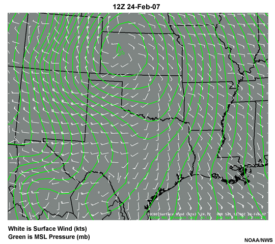
This pattern is a recognized set up for crosswinds in the Dallas-Fort Worth area. The forecasts included information for aviation users long before the onset of the event.
The Aviation Forecast issued prior to the event (at 10:31 a.m. February 23) offered this caution:
2/23/07 Aviation
FINALLY THE MAIN ISSUE IS GOING TO BE WINDS SATURDAY. VERY STEEP
LAPSE RATES WILL DEVELOP AFTER SUNRISE AND MIXING OF 50KT 850 WINDS
SUGGEST THAT 30G40KT WILL MATERIALIZE BY 18Z. DIRECTION WILL BE FROM
240 DEGREES WHICH IS A CROSS WIND FOR ALL RUNWAYS AND WILL RESULT
IN MAJOR DELAYS. TR.92
Question 1
Based on this information, what key points must be included in the forecast products to assist aviation users in their planning? (Choose the best answer.)
The correct answer is b).
The arrival, duration, and intensity of the anticipated weather event, including changes in wind speed and direction, will assist aviation partners in their decision-making process.
Question 2
Given the weather set up for this event and your aviation partners’ needs, which of the following forecasts would you issue? In these products, note that for this event in 2007 the “FM” groups do not include a date. (Choose the best answer.)
The correct answer is c).
The forecast includes time of arrival, duration and intensity for the strong wind event for Dallas-Fort Worth Airport. The other two TAFs do not provide enough detail.
Understand User Needs
Question 1
Based on the weather setup for the DFW airspace, what do you think will be the major concerns for the FAA and airlines? (Choose all that apply.)
The correct answer is a).
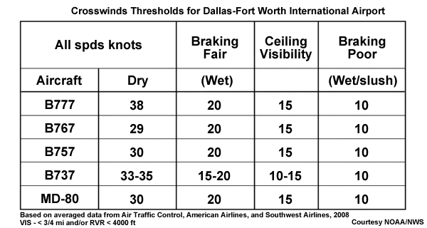
The FAA and airlines will be very concerned with whether the airport will accommodate the traffic as the crosswinds set up. Strong crosswinds can prevent smaller aircraft from landing safely. The forecast values suggest that the AAR of the airport will be significantly diminished for the duration of the storm. The wind values may also exceed the operational thresholds of some aircraft.
The Fort Worth CWSU produced a Headwind/Crosswind Diagram to determine the potential wind impacts. These diagrams are available for several airports nationwide at www.srh.noaa.gov/zfw.
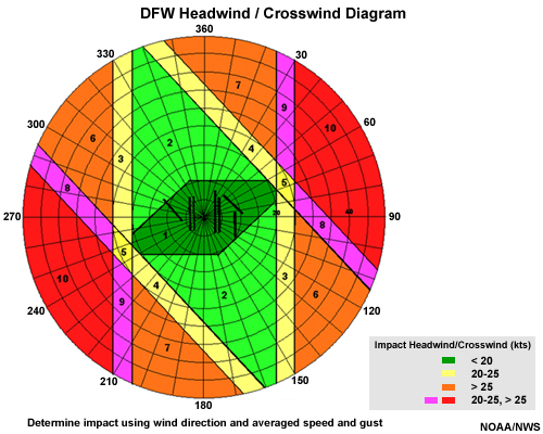
Note how these wind speeds relate to the landing limitations developed by the airlines. These limitations depend not only on the aircraft, but also on runway conditions and other weather components.
Question 2
Given the forecast and your understanding of aviation users’ concerns, what communication and cooperation efforts need to take place? (Choose all that apply.)
The correct answers are a), b), and c).
The event has the potential to severely disrupt operations at the airport. In addition to continuing regularly scheduled collaboration calls, alerting all concerned partners to the threat as early as possible is a wise choice. Increased collaboration and communication between the CWSU and WFO will ensure a consistent message across forecasts.
At 0100Z (7 p.m.) on Feb 23, the CWSU held a call with American Airlines, Southwest Airlines, DFW TRACON TMU, ATCSCC, and ZFW ARTCC TMU. The CWSU meteorologist was adamant about the significant impact to operations at both DFW and DAL to the crosswinds. Some aviation partners thought that DFW could remain in operation the next morning despite the forecasts and strong advisories from the CWSU. However, several airlines did plan cutbacks in operations to the airports.
Anticipate the Impacts
At 1440Z (8:40 a.m.), the following Meteorological Impact Statement was issued:
                     1440Z 2/24/07  MET IMPACT STATEMENT
                     STG WNDS BLW 100 OVR ALL ZFW. SFC WNDS GRTR 30 KTS
                     DVLPG AFT 15Z NW TX RMNG W OF GAG-DFW-ACT LN. ALSO NW TX
                     DVLPG AFT 15Z EXPECT VIS 1-3SM BLDU AND SPRDG EWD.
The winds were expected to develop after 15Z (9:00 a.m.) and blowing dust could contribute to limited visibility.
As the event unfolded, the following observations were recorded:
                     Location  Time  Winds
                      KDFW    1153Z 18018G24KT
                      KDFW    1453Z 26024G30KT PK WND25030/1446
                      KDFW    1553Z 24017KT PK WND 28027/1504
                      KDFW    1653Z 23026G33KT PK WND 23036/1632
                      KDFW    1753Z 25024G33KT PK WND 24034/1743
                      KDFW    1853Z 25035G45KT PK WND 26045/1852
                      KDFW    2353Z 28021G29KT PK WND 28038/2257
                      KDFW    0253Z 29021KT PK WND 29027/0240
Question
What impacts would you anticipate for aviation interests during this period? (Choose the best answer.)
The correct answer is f).
DFW began operations for the day at 108 AAR. The aircraft acceptance rate was reduced to 42 AAR at 1630Z (10:30 a.m.) and continued to deteriorate over the next couple of hours. If a reduced AAR is expected for the event, a Ground Delay Program could be planned and implemented.
After the weather conditions prevented a number of planes from being able to attempt a landing, a Ground Stop on DFW arrivals was initiated at 1815Z and DFW was shut down at 1845Z/12:45 p.m. At DAL, a regional jet was blown off the runway at 1900Z/1:00 p.m. DFW operations remained extremely limited through 2348Z/5:48 p.m. In all, the airlines cancelled over 500 flights that afternoon. Peaks winds during the event measured 49 kts, from 250 degrees.
TRACON Log Summary
1201 S 4 VFR 108
1502 NW FLOW 54 RATE WIND 270/22
1542 2NW FLOW VFR 42 RATE
1624 NW FLOW 48 RATE NOW
1716 DFW AT 42 RATE NOW
1815 STOP DFW ARRIVALS DUE TO WIND/MISSED APCHS
1853 EGF400 WENT INTO GRASS LANDING 31R RWY CLOSED.
ATCSCC NOTIFIED. 31L OPEN FOR ARRIVALS
2334 DFW ARR OVR BYP CROSS KARLA @100 FOR 31R
2348 DFW 30 ARR
0314 DFW 4 NORTH VFR 120 RATE
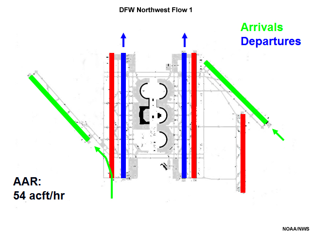
Wind gusts of 22 kts were reported at 1502Z (9:02 a.m.). DFW was in a northwest flow with 54 AAR. This configuration allows only the two northwest-oriented runways for arrivals and two runways for departures (see below).
Although this event was well forecast, and there was very streamlined communication between the WFO and CWSU, and the CWSU and its aviation users, the impacts were still significant. DFW and DAL were closed to operations for a portion of the day, leading to several flight cancellations. Crosswinds pose a difficult forecasting challenge because the critical thresholds vary by airline, aircraft, airport/runway configurations and conditions, secondary weather conditions, as well as by pilot experience. In fact, crosswind limitations are often driven by what the pilot will accept rather than solely by aircraft type.
Backgrounder: Compression
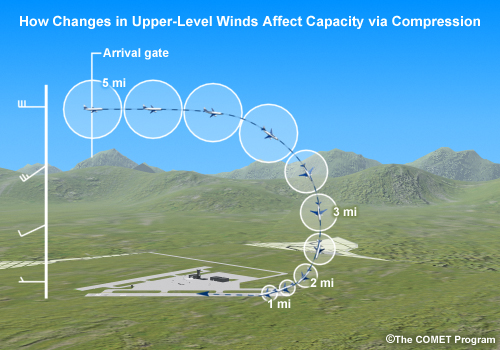
Another aviation concern is compression, which refers to a reduction in horizontal spacing between aircraft as they proceed from the arrival gate to touchdown. Compression occurs as aircraft slow in preparation for landing. Planes are allowed to compress more when visibility is unrestricted by weather or clouds.
Factors such as disparity in aircraft size affect spacing. Due to the potential for wake turbulence (localized turbulence generated by aircraft themselves), a small regional jet would need extra spacing when following a 757 or 767. This extra spacing allows more time for aircraft-generated turbulence to disperse. These local spacing decisions are made by the controller to maintain minimum separation requirements. The pilot can also request extra spacing above the minimum requirements.
In cases of wind shear, aviation operators will be concerned about reductions in the spacing of aircraft transiting from the arrival gate to the runway. The situation is known as "meteorological compression" and occurs when the wind direction changes in the vertical such that an inbound aircraft will experience a tailwind at the gate followed by a transition to a headwind on final approach. This meteorological compression will further reduce aircraft separation beyond the normal reduction that would be created by decreasing airspeed alone. If not anticipated, the effects of this can disrupt the flow of traffic through the TRACON.
Question 1
Let’s look at the wind field in the example below. The winds are from the west with increasing speeds aloft. What concerns should be passed along to TRACON and the Tower? (Choose the best answer.)
The correct answer is b).
Aircraft approach the airport from the northwest arrival gate with a tailwind and then proceed on approach from the east for Runway 27, ending with a headwind on final. At this time, the amount of compression is negligible.
Question 2
Later on, winds aloft increase, setting up increased wind shear as traffic moves through the arrival gate and prepares for landing. Should traffic managers be concerned about it? (Choose the best answer.)
The correct answer is a).
The increased westerly wind shear will cause significant compression. In order to maintain spacing on the final approach, traffic managers have two options. One is to decrease throughput at the gate (an en route spacing issue). This process works only as long as demand for the gate is less than the reduced capacity. The other possibility is to lengthen the approach route, as shown in the animation. This choice will spread the compression over a greater distance and maintain spacing.
Proper separation ensures enough time for aircraft to clear a runway after landing and also for a pilot to react to an unexpected event. Separation minima depend primarily on whether aircraft in the pattern can maintain visual contact with each other and whether tower controllers can see inbound traffic. Typical separation for visual approaches depend on the type of aircraft involved and are greater through the arrival gate and smaller on short final for landing. The minima for instrument approaches depend on the physical layout of the airport, its instrumentation, aircraft instrumentation, and pilot certification.
Meteorological compression is not a problem by itself. It becomes a problem when it coincides with high demand. Pushes or traffic surges can also be spread out along a longer gate to terminal route when nearing capacity. Such a method is preferred to airborne holding when an arrival route becomes saturated. Reroutes can also come into play in that situation.