Turbulence and Winds
Table of Contents
Introduction
En route operations can sometimes be affected by weather that the pilot might not even see. Mountain wave turbulence can be significant enough to block off a substantial area to air traffic. Forecasters usually have a good handle on whether turbulence might occur, but the exact locations of severe turbulence can be difficult to predict with much lead time.
Air traffic coordinators will want to know about the possibility of moderate to severe turbulence and alert airlines and pilots ahead of time, and schedule reroutes. In this case, we'll look at a weather set-up that resulted in significant turbulence for en route flights as well as wind shifts affecting flights arriving at Denver International Airport. More information about forecasting mountain wave events is available at Mountain Waves and Downslope Winds. As in all the cases, we'll want to understand user needs and properly communicate the threat in the context of aviation impacts.
Identify and Communicate the Threat
Let's consider the following case from late February 2012. Examine the surface analyses for February 24 and the Area Forecast Discussion for February 25.
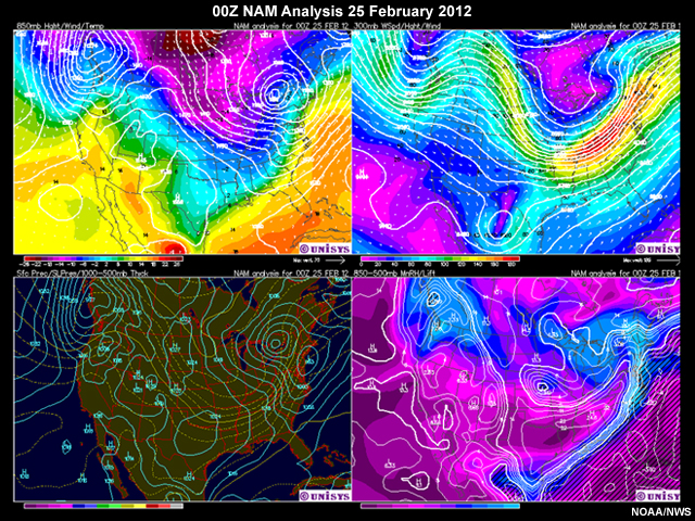
00Z NAM model analysis issued for 5:00 p.m. on February 24 indicates a shortwave ridge with strengthening winds aloft and the potential of a high amplitude mountain wave. Clockwise from top left: 850 mb analysis, 300 mb analysis, surface pressure, 850-500 mb RH/lift.
AREA FORECAST DISCUSSION
NATIONAL WEATHER SERVICE DENVER/BOULDER CO
317 AM MST SAT FEB 25 2012
.SHORT TERM...CLEAR AND RELATIVELY QUIET CONDITIONS AT THE
PRESENT TIME UNDER A SHORT WAVE RIDGE WILL CONTINUE THROUGH ABOUT
MIDDAY
WINDS WILL PICK UP (IN THE AFTERNOON) AS THE FLOW ALOFT
STRENGTHENS BUT AT THIS TIME IT APPEARS THAT ENOUGH INSTABILITY
WILL EXIST TO PRECLUDE THE DEVELOPMENT OF A HIGH AMPLITUDE MOUNTAIN
WAVE. NONETHELESS GUSTS PUSHING 50-60 MPH IN THE HIGHER ELEVATIONS
WILL BE POSSIBLE SIMPLY DUE TO THE EXISTING FLOW
.
.AVIATION...VFR CONDITIONS EXPECTED THROUGH TONIGHT AT AREA
TERMINALS. DRAINAGE FLOWS WILL CONTINUE THROUGH LATE MORNING.
THEREAFTER WINDS GET A BIT TRICKY. BELIEVE KBJC SHOULD SWITCH
AROUND TO WESTERLY WITH GUSTS TO AROUND 25 KNOTS BY EARLY
AFTERNOON. LATEST MODELS SUGGEST THAT KDEN AND KAPA MAY STAY LIGHT
AND VARIABLE THROUGH MUCH OF THE DAY WITH LEE TROUGH/CYCLONE
FLOATING ABOUT THE AREA. EVENTUALLY THOSE AIRPORTS SHOULD SWITCH
AROUND TO WESTERLY BUT IT MAY NOT BE UNTIL LATE AFTERNOON.
&&
Question 1
Based on the discussion, what key points should be included in the forecast products to assist aviation users in their planning? (Choose the best answer.)
The correct answer is d).
The most significant hazards are expected to be winds at the airport and severe turbulence in the arrival gates. Because air traffic decision-makers have to process a considerable amount of information in a short time, it is better to highlight only those hazards most likely to impact their operations. There is no need to emphasize ceiling or visibility concerns in briefings as VFR weather is expected.
The CWSU meteorologist can diagnose and predict a mountain wave with some skill using tools available in AWIPS and other sources. He or she should also monitor PIREPs to assess current conditions and trends for turbulence and mountain waves. The CWSU meteorologist and WFO forecaster should be in contact to discuss the situation and make sure all products and communications offer a consistent message.
Question 2
Based on the information above, what should the forecaster at the WFO include in the morning TAF? (Choose the best answer.)
The correct answer is e).
All of these elements will be important for the decision-making processes of your partners. Per NWS Directive 10-813, all these elements should be included in the TAF. Forecasters are also directed to place special emphasis on elements that might cross impact criteria. For example, a west wind at 25 kt is a criterion for KDEN, because it reduces the AAR due to tailwind/crosswind issues. It is important to be familiar with the key criteria and impacts for your airport.
As the event developed, the WFO and CWSU meteorologists coordinated to ensure that information affecting terminal operations was included. The CWSU meteorologist sent this TAF coordination message:
    DEN TAF COORDINATION
    1350Z 25 Feb 2012

    I AGREE WITH YOUR AVIATION DISCUSSION. HOWEVER, AWIPS E-W CROSS SECTION THROUGH DEN
    FROM THE NAM MODEL IS SUGGESTIVE OF DEVELOPMENT OF A STRONG LOW AMPLITUDE MOUNTAIN
    WAVE.  THIS COULD PRODUCE MORE WIDESPREAD LOW LEVEL SEVERE TURBULENCE THAN FROM THE
    STRONG MOUNTAN TOP WINDS ALONE. THIS COULD IMPACT DEN TRAFFIC IN THE GATES, ESPECIALLY
    ON THE WEST SIDE OF THE AIRPORT. IF THE MOUNTAIN WAVE BREAKS, THIS COULD ALSO SEND
    STRONGER WINDS DOWN AND OUT OF THE FOOTHILLS TO THE AIRPORT EARLIER AND STRONGER
    THAN EXPECTED. I WOULD NOT BE SURPRISED TO SEE GUSTS EXCEEDING THE 25 KT THRESHOLD FOR
    WEST-ALL OPERATIONS BY MID AFTERNOON.
Soon after, the WFO forecaster responded to the CWSU:
    DEN TAF COORDINATION
    1358Z 25 FEB 2012

    I UNDERSTAND YOUR CONCERNS. I COULD GO WITH WEST WINDS 20G30KT IN THE TAF STARTING
    AT 22Z IF THAT'S OK.
Next, the CWSU meteorologist communicated the forecast to the TMU, TRACON, and the Tower. In this situation, the TMU and TRACON/Tower need to know about changes in winds (anything that might cause tailwind, crosswind, or low-level wind shear issues on approach, landing, and departure). The TRACON and Tower also need to know about anticipated peak gusts at the airport, and about changes in wind direction and their timing. The TMU coordinators need to know of any moderate or greater turbulence that flights might experience en route and in the vicinity of arrival and departure gates.
Question 3
In addition to coordination efforts with the local WFO and communication with the TMU, TRACON and the Tower, what other organization would need to be updated on the potential en route and terminal weather impacts? (Choose all that apply.)
The correct answers are a) and b).
The CWSU meteorologist would need to coordinate with the ATCSCC as well as with the AWC if the weather issues were expected to affect a larger area. The communication between CWSUs and the ATCSCC may be indirect via the Supervisory Traffic Management Coordinators (STMCs) at the Center or can be direct with the National Aviation Meteorologist (NAM) at the ATCSCC when he or she is available, usually during peak daytime hours. The AAWU will not be involved in this case as it is outside their area of operations.
Understand User Needs
The CWSU forecaster consulted with the AWC around 10:15 a.m. after reports of severe low level turbulence became more frequent and widespread across the Denver control area. This coordination resulted in the AWC issuing SIGMET Victor 1:
    WSUS05 KKCI 251745
    WS5V
    SLCV WS 251745
    SIGMET VICTOR 1 VALID UNTIL 252145
    WY CO
    FROM 20WNW BFF TO 30SE PUB TO 40SW HBU TO 50E OCS TO 20WNW BFF
    OCNL SEV TURB BLW 160.  RPTD BY ACFT.  CONDS CONTG  BYD 2145Z.
Question 1
With the likelihood of a mountain wave event impacting an arrival gate over some time period, what would a traffic management coordinator need to do? (Choose the best answer.)
The correct answer is a).
The traffic coordinator will attempt to distribute traffic into a manageable flow. Strong winds or turbulence in an arrival gate can result in airlines requesting different arrival routes and in some cases might require temporarily closing a gate. Strong winds in the arrival gates of a major airport coupled with winds of the opposite direction at or near the ground can cause unusual traffic patterns for a TRACON airspace due to traffic compression. Option b does not take into account the changes in weather, while option c institutes a very restrictive program that may be unnecessary.
Traffic management requires extra concern when mountain wave conditions and associated strong winds and turbulence set up. Strong winds at jet stream level can spur commercial dispatchers to file flight plans that give traffic a wide berth around adverse winds to reduce fuel consumption. Conversely, dispatchers may file plans that optimize fuel efficiency for traffic going with the winds. The net result could be unusually high traffic for some ATC sectors and unusually low traffic for others.
Question 2
After the issuance of the SIGMET, the CWSU forecaster needs to update the traffic managers about the turbulence. Select the best briefing to give your aviation users from the choices below.
The correct answer is b).
The briefing text gives a concise and correct depiction of the event and its impacts on the TRACON. The other two briefings are vague about the turbulence's strength and its potential impacts.
Anticipate the Impacts
Question
What impacts would aviation partners be most likely to experience during this mountain wave event? (Choose all that apply.)
The correct answers are b) and c).
Surface winds at DEN shifted to west 25 to 35 knots forced an all-west runway configuration for over six hours. At Denver International Airport, the all-west configuration substantially reduces the AAR. In addition to the surface wind effects on runway configuration, strong winds and turbulence aloft meant some inbound flights needed to be rerouted to different arrival gates. Both of these issues contributed to flight delays.
In this case, the event was fairly well forecast, and effective communication between the CWSU, WFO, AWC, and ATCSCC helped maintain consistency among the products at the local and national levels. FAA decision-makers were kept up-to-date on the timing and location of the most severe conditions. Miles-In-Trail restrictions help regulate the traffic coming into the Denver airspace to adjust for the shut-off gate, and allow time for the runway switch at Denver International Airport.
Backgrounder: Miles in Trail
MIT (Miles in Trail) relates to the number of miles required between aircraft to meet a separation restriction over an airport fix or along a route or volume of a sector. For example, standard separation between aircraft in the en route environment is 5 nautical miles. A TMC might initiate a restriction of 15 MIT to triple the spacing between aircraft along a specific route. An MIT restriction is typically issued by TMCs to:
- Manage traffic within their own control space
- Regulate traffic leaving their control space, by request from a neighboring ARTCC Traffic Management Unit
Aircraft need extra room to deviate around areas of turbulence or compensate for weather-driven changes in altitude or airspeed. The effects of turbulence on airspeed and traffic management initiatives to ensure safety are illustrated below.
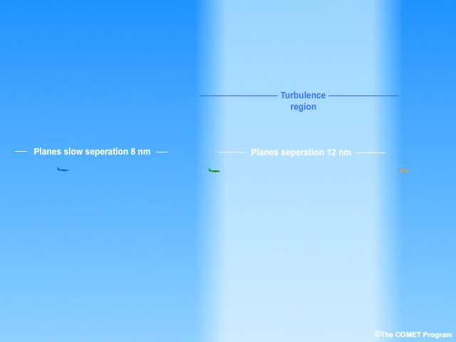
In normal conditions, pilots maintain a minimum of five nautical miles separation between all aircraft. If severe turbulence or a strong mountain wave forms along the route, the air traffic would compress, possibly compromising safety. The en route center will initiate a miles-in-trail restriction to separate traffic. Here, planes decrease their speed to achieve a 10 nautical mile separation ahead of the turbulence region and in turn maintain the necessary separation with planes inside the region by placing fewer aircraft in the same airspace. The initiative decreases capacity but ensures safety along the route until the hazard subsides.
MIT cannot be used when aircraft are operating in a non-radar environment or are transitioning to a non-radar environment. In this case, minutes-in-trail (MINIT) is used, referring to the number of minutes needed between successive aircraft. The MIT/MINIT restriction causes relatively minor impacts on the NAS in terms of time and space. Its effects are mitigated rapidly on both sides of the restricted route because the altered traffic is absorbed into many other streams of traffic.