Introduction to the NAS
Table of Contents
Weather and Air Traffic Management
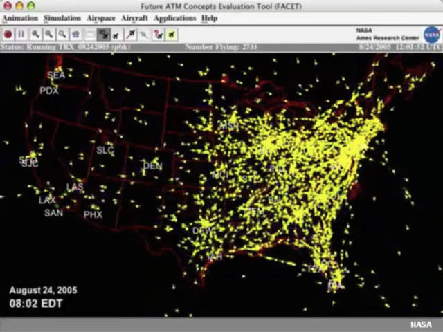
The U.S. airspace is a busy place. This animation starts at 8 p.m. EDT and runs until 8 p.m. the next evening. Starting around 5:00 a.m., activity at Memphis, home of FedEx, picks up first, and then the morning flights begin leaving the East Coast. The next big activity is at Chicago, and then Dallas and Denver, and continues to propagate westward as the day begins. During peak times of the day, over 5000 aircraft will be sharing the airspace over the U.S.
With so much going on, a glitch or delay in one place can cause problems throughout the system. And the biggest source of delays for air travel is…weather.
Low ceilings and visibility account for the majority of weather delays, but thunderstorms also play a large role, especially during the convective weather season.
In this online lesson, you’ll learn about the weather impacts on air traffic and the role of the National Weather Service (NWS) in helping the Federal Aviation Administration anticipate and mitigate these effects. After completing the material, you should be able to:
- Identify the components of the National Airspace System (NAS)
- Describe the components of the Federal Aviation Administration (FAA) Air Traffic Organization (ATO)
- Identify how various weather events affect the NAS and its different components
- Describe the needs of the FAA for weather information
- Produce a briefing that meets these needs for various situations, in a language appropriate to the FAA
- Given various weather or natural hazards, follow best practices for forecasters in the Center Weather Service Units (CWSUs), Weather Forecast Offices (WFOs), Air Traffic Control System Command Center (ATCSCC), Aviation Weather Center (AWC), and Alaska Aviation Weather Unit (AAWU) to:
- Identify their aviation partners’ needs and decide what coordination efforts to initiate
- Communicate weather information about the issues of greatest concern to their FAA partners for terminal and en route operations
- List key ways that aviation meteorologists provide Decision Support Services to the NAS
Lesson Organization
The lesson content is divided into example cases addressing aviation forecasting and impacts for various natural hazards. The material is organized into sections to allow you to proceed through the cases in any order, but if you are new to aviation forecasting, continue through the next pages for background information about the National Airspace System and the National Weather Service's role in providing critical and timely forecasts for decision support.
Summary of Lesson Contents
- Introduction to the NAS (40 min)
- Snowstorm (20 min)
- Backgrounder: Ground Delay Program
- Backgrounder: Ground Stop
- Volcanic Ash (10 min)
- Thunderstorms (20 min)
- Backgrounder: Rerouting
- Backgrounder: Severe Weather Avoidance Program
- Crosswinds (20 min)
- Backgrounder: Compression
- Turbulence and Winds (20 min)
- Backgrounder: Miles in Trail
- Fog (15 min)
- Space Weather (2 min)
- Forecaster Practice (35 min)
Time to complete full lesson ~3 hours
NWS and the NAS
The National Airspace System (NAS) is a complex set of facilities, procedures, aircraft, and people that create an environment for the safe operation of all types of aircraft. The NAS operates within the atmosphere, similarly to the operation of submarines in the ocean. Both aircraft and submarines are continuously immersed in the flows, currents, and eddies of their respective domains. In the atmosphere, aircraft must be routed around the areas where weather interferes with normal operations.
The Federal Aviation Administration (FAA), part of the Department of Transportation (DOT), is responsible for the air traffic flow management and control. Its mission is to provide the safest, most efficient airspace in the world.
The National Weather Service supports the NAS through operations at its local Weather Forecast Offices, Center Weather Service Units, Aviation Weather Center, the Alaska Aviation Weather Unit (AAWU), and National Aviation Meteorologists (NAMs) staffed to the FAA’s Air Traffic Control System Command Center.
A short description of these entities and their roles follows.
Aviation Weather Center (AWC):
Based in Kansas City, Missouri, the Aviation Weather Center (AWC) delivers timely and consistent aviation weather information to support the NAS.
Along with the Alaska Aviation Weather Unit and the Honolulu Meteorological Watch Office, AWC issues Significant Meteorological Information (SIGMETs), Airmen’s Meteorological Information (AIRMETs), Area Forecasts, and upper-air prognostic charts, which provide information about anticipated weather hazards over both national and international airspace. AWC operates the Aviation Digital Data Service (ADDS) website and issues the Collaborative Convective Forecast Product (CCFP) multiple times a day during convective season.
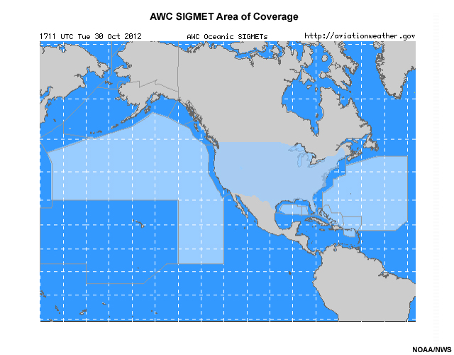
AWC is the Meteorological Watch Office for the contiguous U.S. and oceanic areas off the east and west coasts (see light blue areas on the figure). The Washington Volcanic Ash Advisory Center provides Volcanic Ash Advisories for the AWC area of responsibility.
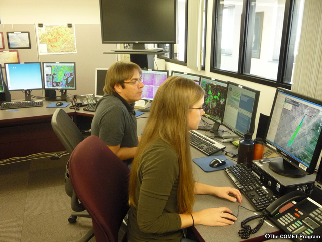
Center Weather Service Units (CWSUs):
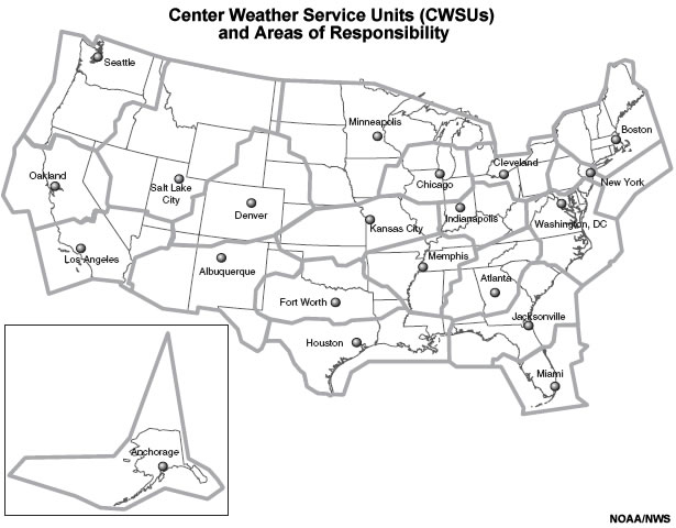
CWSUs are located at FAA Air Route Traffic Control Centers (ARTCCs), where en route flights are managed. The 21 CWSUs nationwide directly support the FAA’s detailed weather information needs. CWSU meteorologists work with the ARTCC and Terminal Radar Approach Control (TRACON) traffic management coordinators and deliver stand-up briefings at least twice per day to facilitate any weather impact planning. They provide ongoing weather updates to the ARTCC Area Supervisors and terminal facility personnel throughout the day. CWSUs also issue Center Weather Advisories and Meteorological Impact Statements to support tactical and strategic flight operations. CWSU meteorologists collaborate with AWC to produce routine Collaborative Convective Forecast Products (CCFPs), which offer guidance about anticipated convective weather affecting Traffic Flow Management (TFM) decisions. The CCFP bridges the transition between strategic and tactical operations.
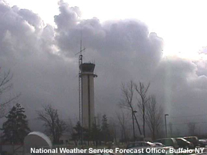
Weather Forecast Offices (WFOs):
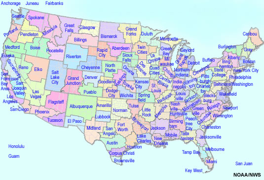
122 Weather Forecast Offices nationwide produce localized Aerodrome Forecasts (TAFs). These forecasts apply to an area with a five statute mile radius from the center of an airport runway complex and are issued for 24- or 30-hour periods. TAFs are issued at three or six-hour intervals depending on the airport, and are amended as needed.
Because changes in conditions can mean big impacts to aviation, an updated and accurate TAF is extremely important. Here, Karen Olsen at the Phoenix TRACON discusses the importance of TAF accuracy regarding the onset of winds and a dust storm.

Karen Olsen, Phoenix TRACON
Click the play button to start the audio.
Karen Olsen, Phoenix TRACON: “As far as the accuracy of the TAF, it is extremely important for air traffic because we are not only planning on the shift personnel to have enough coverage if we go into a type of situation instrument rules. Obviously, we will need more people, we will need a hand-off position—that particular position requires two people as opposed to one before. So you can see how the workload is definitely higher when it gets down to an instrument situation. We, in Phoenix, are grateful when there is wind information because it can quickly turn in an instrument condition here even though there are no clouds or the visibility was not affected before the dust started blowing. The haboob situation is very real here in Phoenix and it does cause havoc for the Phoenix airport.”
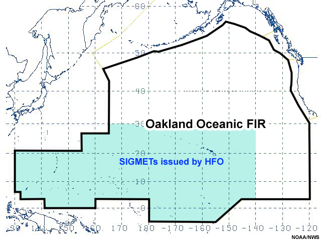
The Honolulu Weather Forecast Office (HFO) operates as the Meteorological Watch Office for an area of the Oakland Oceanic Flight Information Region (FIR) covering more than eight million square miles of the central and western Pacific. In this capacity, HFO issues aviation forecasts for both domestic and international travel.
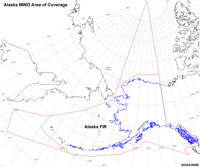
Alaska Aviation Weather Unit (AAWU)
The Alaska Aviation Weather Unit is a Meteorological Watch Office providing Area Forecasts, AIRMETs, and SIGMETs for the Anchorage Flight Information Region. AAWU is also home to the Anchorage Volcanic Ash Advisory Center (VAAC), which monitors over 100 historically active volcanoes in the region.
Air Traffic Control System Command Center (ATCSCC) meteorologists:
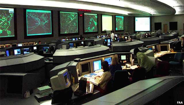
A small cadre of National Weather Service National Aviation Meteorologists (NAMs) synthesizes weather information from various NWS sources into a consistent message to directly support weather operations at the ATCSCC. Operated by the FAA, the ATCSCC regulates air traffic when weather, equipment, runway closures, or other impacting conditions place stress on the NAS. In these instances, Traffic Management Personnel at the ATCSCC take actions to modify traffic demands in order to remain within system capacity.
Question
Match the NWS organizations with their respective descriptions. (Use the selection boxes to choose the best answer for each of the statements below, then click Done.)
Compare your selections to the correct answers above.
FAA's Air Traffic Organization (ATO)
As a weather service forecaster, you will interact most often with the FAA’s Air Traffic Organization (ATO). The Air Traffic Organization operates a network of Air Traffic Control Towers (ATCTs), Terminal Radar and Approach Control facilities (TRACONs), Air Route Traffic Control Centers (ARTCCs), and Automated Flight Service Stations (AFSSs). The ATO develops air traffic rules, assigns the use of airspace, and controls air traffic flow, serving commercial, private, and military aviation. The ATO employs approximately 35,000 controllers, technicians, engineers, and support personnel.
The National Weather Service’s Center Weather Service Units (CWSUs), Weather Forecast Offices (WFOs), and Alaska Aviation Weather Unit (AAWU) provide weather support to the TRACONs and ATCTs. You can learn more about the FAA facilities supported by NWS meteorologists in The Impacts of Weather on Air Traffic Management.
Flight Simulation
Understanding the roles of the various FAA facilities can be complicated because of the number of people involved. The simulation below enables us to listen in on the communication between the pilot and various FAA facilities and get an idea of how they all work together.
Let’s join the pilot in command on Ski Airlines Flight 123 from Denver to Salt Lake City. She has received information from her dispatcher, reviewed weather information, and filed a flight plan. This plan tells the controllers along the route where the pilot intends to fly and at what levels. Ski Airlines Flight 123 is at the terminal gate and the pilot is ready to communicate with the control tower. You’ll be able to hear the dialog between the pilot and controllers through each phase of the flight, including the issuance of a Center Weather Advisory.
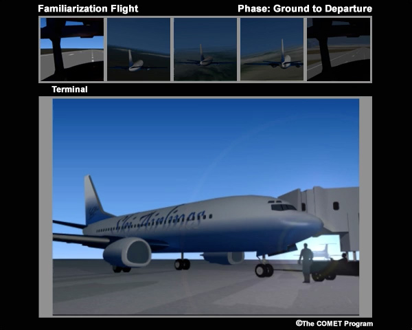
Ground-to-Departure Phase (Pilot communicates with Tower, then TRACON until handoff to Center)
Pilot (P): Good morning, ramp control. Ski 123 requesting push back from gate.
Controller (C): Ski 123, ramp control, push back approved.
P: Good morning, ground control, Ski 123 ready to taxi with Juliet.
C: Ski 123 taxi to runway 34L via taxiway Echo then Alpha, contact tower on 135.3.
P: Taxi to runway 34L via Echo and Alpha, tower on 35.3.
P: Morning tower, Ski 123 at runway 34L.
C: Ski 123 cleared for takeoff.
P: Roger, cleared for take off, Ski 123.
C: Ski 123 contact departure at 126.1. Good day.
P: Departure on 26.1, Ski 123.
P: Denver Departure, Ski 123 at 8 thousand.
C: Ski 123, radar contact, fly heading 275.
P: Roger Denver, heading 275.
C: Ski 123 climb to 16 thousand and contact Denver Center on 123.20. Good day.
P: Climb to 16 thousand and contact Center on 23.20.
En Route Phase (Pilot communicates with Center controllers in ARTCCs)
P: Good morning, Denver Center. Ski 123 at 12 thousand climbing to 16 thousand.
C: Ski 123, climb to Flight Level 350.
P: Climb to Flight Level 350.
C: Attention all aircraft. Hazardous weather information Center Weather Advisory 101 for western Colorado and eastern Utah available on HIWAS, Flight Watch, or Flight Service frequencies.
C: Ski 123, contact Salt Lake Center on 124.50.
P: Contact Salt Lake on 24.50, Ski 123.
P: Salt Lake Center, Ski 123 at Flight Level 350.
C: Ski 123, roger. How's your ride?
P: Light to moderate chop, Ski 123.
C: Ski 123, contact Salt Lake Center on 132.85.
P: Salt Lake Center on 32.85, Ski 123.
P: Good morning Salt Lake Center. Ski 123 at Flight Level 350.
C: Ski 123, Roger.
C: Ski 123, Salt Lake Center, descend to Flight Level 200.
P: Roger, Salt Lake, descend to Flight Level 200.
C: Ski 123, contact Salt Lake approach on 128.1.
P: Contact Salt Lake approach on 281. Good day.
Approach-to-Landing Phase (Pilot communicates with approach TRACON, then Tower)
P: Salt Lake approach, Ski 123 descending to Flight Level 200 with information Sierra.
C: Roger, Ski 123. Join SPANE4 arrival, cross SPANE at 16 thousand, expect runway 34 Right. SLC altimeter 2993.
P: Join SPANE4 arrival, cross SPANE at 16 thousand, expect runway 34 Right, altimeter 2993.
C: Ski 123, contact Salt Lake tower on 119.05.
P: Salt Lake Tower on 19.05. Good day.
P: Salt Lake Tower, Ski 123 at 8 thousand inbound for 34 Right.
C: Ski 123, reduce speed to 160 for spacing, cleared to land runway 34 Right.
P: Reduce speed to 160, cleared to land 34 Right.
C: Ski 123, contact ground 133.65.
P: Roger ground, 33.65.
P: Ground, Ski 123, taxi to gate.
C: Ski 123, taxi to gate via taxiway tango.
P: Roger, ground, taxi to gate via tango.
Question
Based on what you learned so far and the familiarization flight animation, match the FAA organizations with their appropriate descriptions. (Use the selection boxes to choose the best answer for each of the statements below, then click Done.)
Compare your selections to the correct answers above.
FAA Terminology
An understanding of the FAA terminology is also helpful: as with any culture, air traffic personnel have developed their own set of acronyms, words, and phrases to communicate effectively.
Question
Practice your understanding of FAA terminology. Match the definitions to their appropriate words using the selection boxes. When finished, click Done.
Compare your selections to the correct answers above.
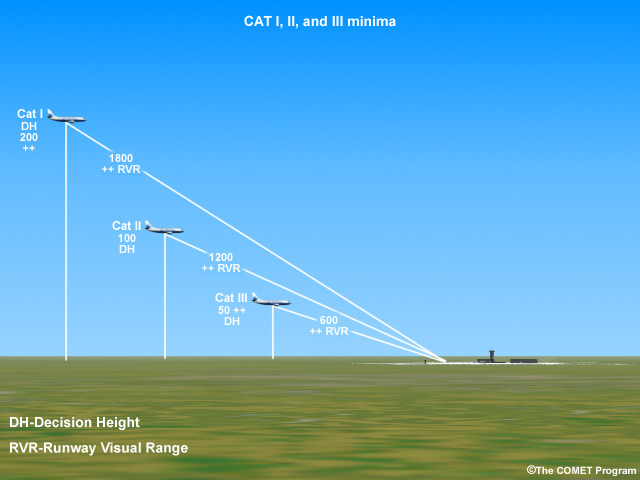
CWSU forecasters might hear the terms “CAT I, CAT II, or CAT III,” which refer to aircraft and crew certified to land in specific minimum conditions via an ILS approach on a properly equipped runway. The following are general definitions for International Civil Aviation Organization (ICAO) precision instrument approaches and landings.
- CAT I certified aircraft and crews can land with a Runway Visual Range (RVR) of no less than 1800 feet and a decision height (DH, height above the runway where the crew has to see the runway or abort the landing) of 200 feet.
- CAT II minimums are 1200 feet Runway Visual Range (RVR) and 100 feet decision height and 1600 feet Runway Visual Range (RVR) with a decision height of 150 feet.
- CAT III minimums are a 600 feet RVR and a decision height of 50 feet, although they can be as low as 0 feet ceiling and 0 feet visibility.
Flight level is also a common reference in aviation operations. Flight levels are reported as a three-digit number providing a standardized pressure altitude (above mean sea level) in hundreds of feet. For instance, 32,000 feet is referred to as FL320 (read as Flight Level Three Two Zero) and 8,000 would be referred as 080 (read as 8000 feet). The “FL” abbreviation is only appended to flight levels greater than or equal to 18,000 feet or FL180. FL190 would be read as Flight Level One Niner Zero. Pilot reports (PIREPs) refer to flight levels above mean sea level. On TAFs and METARS that are airport specific, the altitudes provided correspond to above ground level (AGL).
The term “core airports” refers to the airports handling the largest amounts of air traffic (see list). Weather impacts at the core airports will negatively affect the NAS due to the sheer volume of traffic that passes through them. Issuing meteorologically accurate TAFs that account for the operational thresholds of the airports and the decision points of their users is one of the best ways to support them. Another way is to be proactive with forecast updates. For example, if the current 15Z TAF has TS at 17Z, but at 16:10Z the meteorologist on duty determines that a line of thunderstorms will impact the airport at 17:40Z, updating the "FM" group for TS to start at 1740Z would be very helpful to core airports in your area. These and other ways to serve your users are discussed in the cases detailed in this training.
For more terminology, see the FAA Glossary. Understanding the terminology of your aviation users will help you communicate with them more effectively. As you become familiar with the types of weather impacts in your area, you will develop greater knowledge of the needs of your aviation partners and maximize the usefulness of your products.
Listen as Rick Curtis at Southwest Airlines describes the importance of knowing your airport and its minimums and thresholds to optimize your forecast.

Rick Curtis, Southwest Airlines
Click the play button to start the audio.
Here is what Rick Curtis at Southwest Airlines says regarding the importance of knowing your airport and its minimums and thresholds to optimize your forecast:
Rick Curtis, Southwest Airlines: “If I could tell them one thing, it would be to know your airport. And you have to know what equipment is working, what equipment isn’t, and to know the users of that airport. For example, you could have a CAT-III airport that you have a lot of regional jets and commuter jets flying in that aren’t CAT-III equipped and you’re thinking that some of your forecasters don’t have to be very high precision or you’re not thinking about what those minimums are for the majority of operators at that airport, then you could be very much out of synch with what the consumers of that forecast are looking for.”
Phases of Flight
A flight generally consists of five phases:
- terminal - the aircraft is cleared and takes off from the assigned runway
- departure - the aircraft departs local air space
- en-route - flight between the terminals
- approach - approach and descent towards the terminal
- terminal- landing on assigned runway and taxi to terminal
The following animation shows which ATO and weather units contribute to each phase.
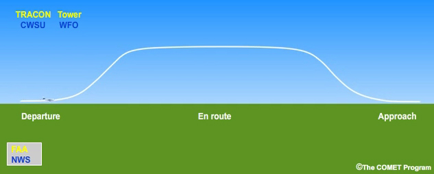
As the pilots prepare for departure, they review information from the Weather Forecast Office and receive guidance from the local Tower and TRACON informed by input from the CWSU. Once en-route, the flight is monitored and guided by the Air Route Traffic Control Center and the Air Traffic Control System Command Center. Both receive weather input from the Aviation Weather Center and the CWSU. As the pilots prepare to land, they are guided again by TRACON and the local Tower, each of which received weather information from the Weather Forecast office and the CWSU.
Some shorter flights or smaller airports may not be handled by a TRACON/APPROACH facility and instead are guided by the Towers and ARTCC.
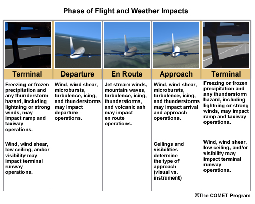
Weather can affect any phase of a flight. The following table summarizes the impacts.
Airline partner Rick Curtis discusses how weather, both at the airport and en route, affects planning for operations.
Rick Curtis, Southwest Airlines
Click the play button to start the audio.
"There’s really two distinct ways of looking at weather for our operations. The first is the terminal itself and what’s going to happen at the airport in terms of landing minimums, takeoff minimums, crosswinds, grounds ops equipment, deicing, that sort of thing. So that’s just one area. On the other side of the wall if you will, we look mostly at en route weather. En route weather is largely affected by convection so that’s really the biggest issue we have. The second issue would obviously be the winds, particularly jet streams. From a general sense you try to look at convection, you look at winds, and then you look at traffic based on what routes you’re going to be able to get based on the traffic flows that ATC works out."
Terminal Operations
Terminal operations include the first or final phase of takeoff or touchdown and taxiing between ramp and runway. The following weather elements can impact terminal operations:
- Icing (accumulations of frost, snow, freezing rain/drizzle on aircraft surfaces)
- Convective hazards (thunderstorms, lightning, microbursts, hail)
- Non-convective low-level wind shear
- Precipitation (runway conditions—braking action, snow/ice removal)
- Wind direction and speed
- Cloud ceiling heights
- Visibility (tower, field, and Runway Visual Range)
- High density altitude (associated with high temperatures) affecting lift
To maximize forecast value for the NAS, every aviation forecaster should have a working knowledge of the airfields they serve. This knowledge will help meteorologists create tailored products that are sensitive to critical aviation decision points. The main factors that dictate weather-sensitive air traffic constraints for specific airports are:
- Thresholds for winds, ceilings, and visibilities
- Available runways
- Runway configuration
- Types of approaches
- Required approach/landing minima
- Alternate minima
- Traffic density
A good understanding of the potential operational impact of a forecast is necessary to avoid unintended impacts and increase user satisfaction with the information. CWSU forecasters can help their colleagues in the WFO to become familiar with the operational thresholds for airports in their service area.
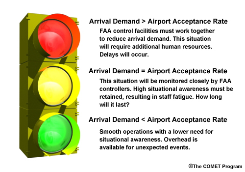
Terminal capacity is determined by the airport arrival rate (AAR), alternatively termed the aircraft acceptance rate. AAR refers to the number of aircraft per hour that Tower or TRACON traffic managers believe they can safely land. The maximum AAR depends on the layout of the airport, including number, length, and separation of runways. In general, the AAR is reduced by suboptimal weather conditions and restricted runway/taxiway availability. Airport demand increases at certain times of the day (a “push”), so getting the details of the forecast correct for these peak traffic periods is particularly important. Wind is a critical factor in determining which runways can be used, while ceilings and visibility determine if an instrument approach is required.
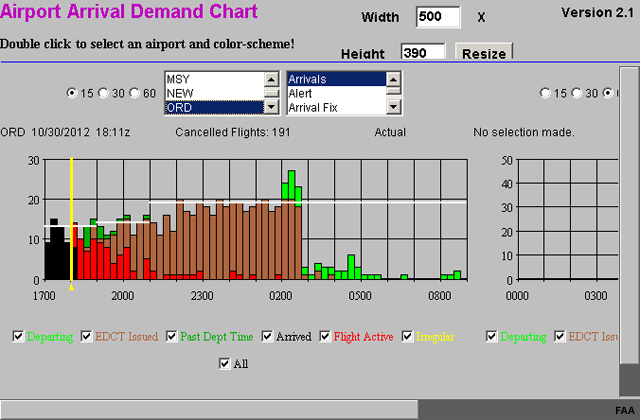
Airport Arrival Demand Chart for Chicago O'Hare International Airport after Hurricane Sandy disrupted air travel on the East Coast. The values in red indicate the number of active flights inbound to the airport. The values in brown indicate the number of flights given Expected Departure Clearance Times (EDCTs) to help time their arrivals to the airport. Once these flights depart, they will be marked active and shown in red.
Question
Under what traffic conditions could an airport handle significant weather without impacting its ability to receive aircraft? (Choose the best answer.)
When airport demand is:
The correct answer is a).
In general, an airport can handle weather without impacting capacity if the demand at any given time remains below the AAR. At busy airports, such as Newark International Airport (EWR) in New Jersey, or San Francisco International Airport (SFO) in California, demand can exceed capacity even when weather conditions are optimal. The FAA must constantly collaborate with the airlines to balance the system. Unanticipated weather impacts that reduce the AAR during a push at a busy airport can cause delays to propagate throughout the NAS.
Aircraft must land via an Instrument Flight Rules (IFR) approach when ceilings or visibilities are below Visual Flight Rules (VFR) conditions. An IFR approach spaces the aircraft farther apart as they land via an Instrument Landing System (ILS), which reduces the AAR. Not all runways at an airport are ILS-equipped, which further reduces the AAR. IFR or Low IFR (LIFR) conditions, combined with different types of arriving airplanes, add stress to the system and may even require some airports to close.
Approach and Departure Operations
TRACONs control the approach and departure phases of flight, including the transition from en route to terminal operations and vice versa. Aircraft enter and depart the TRACON airspace through pre-established "gates" or approach and departure routes. Each forecaster should have working knowledge of the TRACON operations in their area. The CWSU forecasters will have helpful information in that regard.
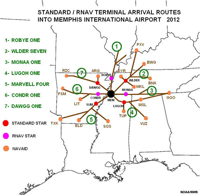
Example showing the main Standard Terminal Arrival Routes (STARs) used at Memphis International Airport (MEM). If weather is expected to impact a route or "gate", aircraft normally using that particular arrival path may be redirected to a different route.
Question
Which of the following weather phenomena have the greatest impact during approach and departure phases of flight? (Choose all that apply.)
The correct answers are a), b), c), d), and e).
Thunderstorms, wind shear, microbursts, and icing have the most impact during these flight phases. Turbulence can also cause significant problems within an approach or departure gate. Pilots report turbulence, icing, or other adverse weather conditions they encounter to controllers, who then relay those reports to other traffic.
En Route Operations
En route operations refer to the aircraft’s journey after it leaves the Tower/TRACON airspace. En route operations can be very complicated, and require active management whether or not weather disruptions affect traffic. Air traffic managers have to coordinate with their counterparts in the ATCSCC, other ARTCCs, and control area supervisors within their own center to anticipate and mitigate adverse impacts. This coordination is important because en route operations directly affect other phases of flight and other users of the NAS.
Weather elements that can significantly impact en route operations include:
- Thunderstorms
- Severe turbulence and mountain waves
- Jet stream winds
- Icing
- Volcanic ash
- Space weather
Traffic Management Initiatives used to avoid adverse weather in en route operations include Miles-In-Trail (MIT), Airspace Flow Programs (AFPs), reroutes, and national or regional Playbook routes. More information about these initiatives can be found in the aviation weather cases in this lesson, as well as in The Impact of Weather on Air Traffic Management, available on MetEd.
Traffic management issues are not just weather-related. An example is a situation where special factors affect the volume of air traffic. For instance, what would happen during a large event--the Super Bowl, a NASCAR race, the Kentucky Derby, or other activities--that draw large numbers of people and bring a high volume of air traffic through a specific portion of the airspace over a specific time period?
Question
Suppose that the Winter Olympics were taking place in Aspen, Colorado. The event brings large volume of traffic from the entire world over a three-week period. What might the FAA do to manage the increased traffic for an extended period? (Choose the best answer.)
The correct answer is a).
The FAA will need to accommodate larger than normal traffic demands for this extended period of time. One way to do this is to pace the flights into the affected airspace. A program that helps manage traffic in these situations is a Special Traffic Management Program (STMP, pronounced “stump”). STMPs are sometimes used to manage unscheduled aircraft operations at airports in close proximity to specific events attracting a significant number of spectators and aircraft. To safely guide aircraft during these events, a STMP requires independent pilots to make arrival and departure reservations prior to their flights to or from airports of concern.
The lesson cases illustrate some of the initiatives, including Miles-in-Trail, used to manage air traffic in adverse weather situations. These initiatives are coordinated by the ATCSCC in collaboration with ARTCCs and the airlines. The ATCSCC transmits an advisory containing the reason for the program including information on the airport(s)/sector(s) involved, dates and times the program will be in effect, telephone numbers, and any special instructions.
As you progress through the sections, you’ll see how weather affects all phases of flight operations and learn about the traffic management initiatives required to deal with different scenarios. Each of the weather cases explores a weather hazard and the forecasting and aviation impacts of that hazard. As you work through the cases, you’ll observe that forecasting for your aviation partners involves three key elements. These elements apply whether you are in a CWSU, WFO, or at the AWC or Command Center and are summarized as:
- Identify and communicate the threat
- Understand user needs
- Anticipate the impacts

Note that these elements are not mutually exclusive. Understanding your users’ needs and knowing the potential impact they might experience will help you identify and communicate the information that is most relevant to their decision-making processes.
Rick Curtis describes the decision-making process that airlines must follow during weather events.
Rick Curtis, Southwest Airlines
Click the play button to start the audio.
Rick Curtis, Southwest Airlines: "So, the hardest decisions that we have to make are deciding, okay: When is this going to hit? How bad is it going to hit? How hard is it going to hit? And, the confidence values again that we get—I have to keep bringing it back to confidence, but that's how we have to make our decisions. We look at as much information as we can and then we assess the confidence values of these various thresholds at these various times, our time milestones, if you will. One of the problems with a strategic decision is that you can't go backwards. Once you make a strategic decision then you're stuck with it. So, if you go and say, "Okay, we're expecting an inch of snow an hour in Chicago or in New York City or Baltimore, for an extended period of time, and that the, crews or the maintenance folks at the airport are not going to be able to keep up with that. We are going to reduce our flights by X percent," that point, once you make that decision, that starts to get the ball rolling. Suddenly, those flights are being cancelled; those cancellations are being communicated to the customers that have tickets on those flights, so those folks are starting to make other arrangements. If that weather doesn't materialize, you can't suddenly go back and say, "Oops, we were just kidding. We're going to reinstate that flight, we're going to re-accommodate your reservation. You don't need to make another…" You see what I'm saying, you can't go backward."