Chicago Snowstorm
Table of Contents
Introduction
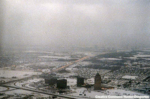
Snow can have a significant impact on terminal operations, arrivals to and departures from the airport. In this case, we'll look at the forecast setup for the day and examine the types of weather information needed by aviation partners. We'll also explore the impacts of this event and the Traffic Management Initiatives (TMIs) put in place to address them.
Identify and Communicate the Threat
Let’s consider the following case. On January 19 the area forecast discussion for Chicago stated the following:
            00Z/0120 Area Forecast Discussion January 20, 2012

              ALL SYSTEMS STILL GO FOR A RESPECTABLE SNOW EVENT FRIDAY INTO FRIDAY
              EVENING ACROSS ABOUT THE NORTHERN 2/3RDS OF THE CWA...

              WATER VAPOR IMAGERY THIS AFTERNOON SHOWS A FAIRLY IMPRESSIVE
              SHORTWAVE TROUGH HAS MOVED ONSHORE INTO NORTHERN CA/PAC NW WITH
              ASSOCIATED 90KT+ 300MB JET STREAK. THIS SYSTEM IS PROGGED TO
              TRANSLATE RAPIDLY EASTWARD THE NEXT 24-36 HOURS MOVING INTO THE
              PLAINS BY 12Z FRIDAY AND EVENTUALLY SHEARING EAST INTO THE EASTERN
              GREAT LAKES BY 12Z SATURDAY. GUIDANCE SUGGESTS ONLY A WEAK SURFACE
              REFLECTION WILL DEVELOP AND TRACK WELL SOUTH OF OUR AREA. FORCING
              FOR ASCENT LOCALLY WILL BE ALMOST ENTIRELY DRIVEN BY WARM AIR
              ADVECTION/ISENTROPIC ASCENT WHICH WILL INCREASE AS LOW/MID LEVEL
              FLOW BACKS/INCREASES IN ADVANCE OF THE WAVE. MODELS DO SUGGEST THAT
              THERE WILL ALSO BE SOME WEAK JET COUPLING BETWEEN DEPARTING POLAR
              JET AND PACIFIC STREAK PROVIDING FOR SOME ADDED EXHAUST
              FURTHER SUPPORTING A PERIOD OF FAIRLY STRONG/DEEP ASCENT.

              FORECAST SOUNDINGS FROM VARIOUS MODELS CONTINUE TO SHOW A DEEP
              ISOTHERMAL LAYER HOVERING AROUND -10C. HOWEVER...FORECAST TIME
              HEIGHT CROSS SECTIONS DO SUGGEST THAT UVVS WILL BE STRONG WITHIN THE
              DENDRITIC GROWTH ZONE BETWEEN ROUGHLY 600-500MB WITH FAIRLY LIGHT
              WINDS ALSO TENDING TO FAVOR HIGHER THAN AVERAGE SNOW TO LIQUID RATIOS.
Question 1
Based on the likelihood of significant weather affecting Chicago and its two major airports, what key points must be included in the forecast products to assist aviation users in their planning? (Choose the best answer.)
The correct answer is a).
Aviation users need to know the onset and duration of the event, the type of precipitation, the intensity, as well as the ceiling and visibility values throughout the event. The other options include valuable information but are incomplete.
At 2339Z, the TAF for Midway International Airport indicated that visibilities would fall to ½ statute mile with snow.
           TAF KMDW 192339Z 2000/2024 31010KT P6SM SKC
              FM200500 VRB03KT P6SM BKN070
              FM201500 11006KT 2SM -SN SCT008 OVC015
              FM201800 10008KT 1SM -SN OVC008
              FM202000 11008KT 1/2SM SN OVC005=
At 02Z, the updated forecast information suggested that visibilities could drop even more severely, to as low as ¼ statute mile, at least during the times of peak snowfall rates.
Question 2
Which TAF amendment for Midway International Airport do you think best captures the key impacts related to this winter weather system? (Choose the best answer.)
The correct answer is b).
The TAF in b) is the amended TAF issued at 02Z January 20 and includes the addition of a TEMPO group with ¼ statute mile visibility associated with snow. Using a TEMPO group for this 18-hour lead time can be useful if confidence is very high. For these and other products, the WFO and CWSU should work together to ensure consistent products for the situation. TAF writers can review best practices for using TEMPO and other TAF writing guidelines.
Understand User Needs
In the January 20 06Z TAFs (abbreviated version for Midway shown here), reduced visibilities and heavier snow are still forecast for 15Z, consistent with the 02Z update. Given the consistency about the timing, aviation operators began planning for possible disruptions at both O’Hare and Midway.
                       KMDW 200528Z 2006/2106 32004KT P6SM SCT250
                          FM201100 VRB02KT P6SM BKN060
                          FM201500 11006KT 2SM -SN SCT008 OVC015
                          FM202000 11008KT 1/2SM SN OVC005
                             TEMPO 2020/2024 1/4SM +SN VV002
                          FM210200 06008KT 2SM -SN SCT005 OVC010=
Question
Based on this forecast, what do you think will be the major concerns for the FAA and airlines? (Choose all that apply.)
The correct answers are b) and c).
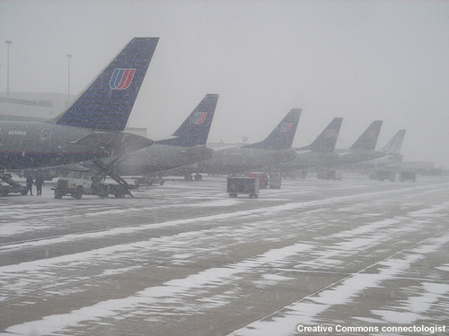
The FAA and airlines will be very concerned whether aircraft heading to the airport will be able to land in the snow/low visibility conditions. The forecast values suggest that the AAR of the airport will be significantly diminished during the storm. If snow accumulation rates are high, departing flights from the airport could also experience issues, not only from the weather, but because inbound flight crews and equipment were unable to reach the airports as scheduled to be ready to depart for their next destinations.
Commercial airlines also like to know the forecaster confidence in the values for the event. Southwest Airlines called the WFO around 5 a.m. and the CWSU meteorologist just prior to 8 a.m. to ask about the confidence levels in the prevailing ½SM and TEMPO ¼SM. The caller referenced a recent event (8 days prior) that had TAFs with ½SM visibility prevailing but in reality the visibility did not drop that low. The forecasters relayed that their confidence of having ½SM visibility as a prevailing condition was moderate to high. The exchanges between the WFO and the airline and between the CWSU and the airline reinforce the importance of coordinating to make sure a consistent message is being communicated. As a result of the weather information provided, Southwest Airlines proactively cancelled all flights to and out of Midway Airport between 20Z and 01Z (2:00-7:00 p.m. CST). For parts of this period, visibility was ¼SM prevailing.
Here is what Rick Curtis from Southwest Airlines says regarding the importance of communicating your confidence in forecast details.

Rick Curtis, Southwest Airlines
Click the play button to start the audio.
Rick Curtis, Southwest Airlines: "What I’m talking about is those key crucial types of forecasts that you know that are important from a decision standpoint. You really need a way to be able to communicate your confidence on those because that’s the name of the game in making decisions. If we have a forecast high impact event with a low confidence on that forecast we probably will not do anything. We could have a lower impact event with a higher confidence and we may take action on that because of the confidence that forecast has expressed."
Knowing the forecaster’s level of confidence for the predicted weather is extremely useful to aviation partners. Some offices, including the Atlanta WFO, already provide this information in all forecast discussions. An example is included here.
            .AVIATION...
            18Z UPDATE...
            SKIES IMPROVING THROUGH THE AFTERNOON WITH MOST AREAS SCT050. SKIES
            WILL CLEAR TONIGHT WITH HIGH LEVEL CLOUDS MOVING IN LATE TUESDAY
            MORNING. WINDS WILL BE NORTHWEST WITH GUSTS NEAR 20 TO 25KTS THIS
            AFTERNOON. WINDS WILL GO NEAR CALM TONIGHT AND THEN LIGHT NORTH
            TUESDAY.

            //ATL CONFIDENCE...18Z UPDATE...
            HIGH ON ALL ELEMENTS.
Anticipate the Impacts
Question
Review the forecast for the winter weather event affecting Chicago and select the correct statement below. (Choose the best answer.)
                KMDW 200528Z 2006/2112 32006KT P6SM SCT250
                    FM201100 VRB02KT P6SM BKN060
                    FM201500 11006KT 2SM -SN SCT008 OVC015
                    FM201800 11008KT 1SM -SN OVC008
                    FM202000 10008KT 1/2SM SN OVC005
                      TEMPO 2020/2024 1/4SM +SN VV002
                    FM210300 06008KT 3SM -SHSN SCT005 OVC010=
The correct answer is a).
The FAA and airlines began planning for possible traffic management actions in a call prior to the event. In this case, visibility was forecast to be only 1/4SM during a four-hour period, restricting the number of landings. Airlines make their own decisions about operating flights, but for flights scheduled to an airport with reduced capacity for landing, the FAA may put a traffic management initiative in place. Reducing the number of flights headed to the airport during a time when demand will exceed the airport’s capacity is called a Ground Delay Program.
Backgrounder: Ground Delay Program
Ground Delay Programs (GDPs) are coordinated among airlines, ATCSCC, and other FAA facilities to accommodate the anticipated demand at an airport. Ground Delay Programs delay flights at their departure point to alleviate traffic demand at their destination airport. The flights that have yet to depart are assigned arrival slots, which might be minutes or even multiple hours later than the originally scheduled arrival time. The arrival slot, along with the en route flight time, is used to issue an Expected Departure Control Time (EDCT) for each affected flight. For instance, a GDP for Midway or O'Hare International Airport might keep a departing flight from Cincinnati on the ground so that it will not hold in the air before landing.
GDPs are typically used when aircraft acceptance rate (AAR) is reduced by at least 40% and the reduced rate will not meet the expected demand. AAR reductions typically occur in adverse weather including unfavorable winds, low ceilings and low visibility and can also have non-weather sources, such as a runway closure. Limiting airborne holding increases safety and reduces fuel costs for aircraft operators. In severely reduced capacity situations (e.g., airport/runway closed for snow removal or aircraft accidents), the GDP process distributes delays equitably among all the airspace users.
Limiting the time the aircraft is forced to hold in the air is particularly important at times of year when icing can occur. Approach holding zones at most major airports are between FL160 and FL200, altitudes where icing conditions are common. If an aircraft is held too long in icing conditions, ice may accumulate faster than its equipment can remove it. The aircraft will eventually lose performance and, in some cases, control. To minimize this threat, traffic managers must reduce arrival volume, minimize aircraft holding time, and/or stop holding aircraft until conditions improve. For more information on this topic, see Forecasting Aviation Icing: Icing Type and Severity and Icing Assessment Using Soundings and Wind Profiles.
Question
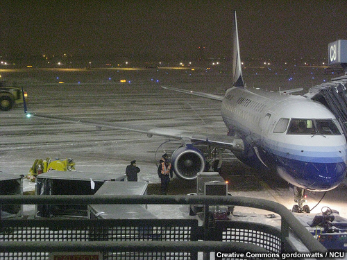
Returning to our Chicago case, the snow intensified and forced closure of all runways at Midway International Airport because airport crews were unable to keep them clear. What might the FAA do to address the loss of the runways? (Choose the best answer.)
The correct answer is a).
At 17:30Z after a call among the FAA, airlines and the airport, the FAA stopped all flights to the airport for a period of time before the planned GDP was to go into effect. This stoppage is also known as Ground Stop (GS).
Backgrounder: Ground Stop
Ground Stops are generally coordinated between FAA facilities and the airlines and are often needed on very short notice. Ground Stops are one of the most restrictive methods of traffic management and are used:
-
In severely reduced capacity situations (below most user arrival minimums, airport/runway closed for snow removal, or aircraft accidents/incidents)
-
To prevent extended periods of airborne holding
-
To keep the ARTCC airspace from reaching near-saturation levels or to prevent airport gridlock
-
In the event a facility is unable or partially unable to perform ATC services due to unforeseen circumstances
-
When routings are unavailable due to severe weather or catastrophic events

Ground Stops are often issued progressively, first for the local control area of an ARTCC and then outward in coordination with the ATCSCC. The local facility may initiate a local GS when conditions are not expected to last more than 30 minutes. The local Ground Stop is implemented when the impacts are wholly contained within the local facility's area of responsibility. These local Ground Stops are typically referred to as internal ground stops. For instance, if the Chicago ARTCC traffic coordinators want an internal GS for O’Hare, all flights with a flight plan departing for O’Hare cannot take off until the GS is lifted. The first tier ground stop would affect flights from the nearest airports. For O’Hare, this would include all flights within the ZAU airspace and would stop short-haul flights to the airport to give the facility a chance to catch up. Sometimes radius values are also used to do a Ground Stop. Ground Stops are coordinated with the ATCSCC.