Dallas-Fort Worth Thunderstorms
Table of Contents
Introduction
What if there are differences in the nuances of a forecast or the weather develops without much lead time? In some cases, traffic management decisions must be made based on varied information, particularly when the precise locations and timing of weather remain uncertain until the event materializes. Planes already be in the air could need to detour, divert, or be asked to hold prior to landing. These situations arise often in cases of quickly developing convective weather, where forecasting the specific areas to be affected can be particularly difficult.
Although a large area might have a threat of convective weather, predicting with long lead times exactly where the storms will develop and move is nearly impossible.
Identify and Communicate the Threat
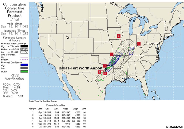
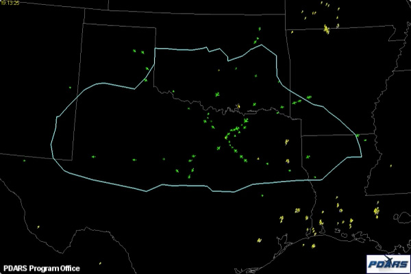
The SPC forecast indicates potential convection over a large area, stretching through Texas northeastward into southern Illinois and Indiana. Review the Collaborative Convective Forecast Product (CCFP) forecasts and decide what needs to be communicated to traffic coordinators at the ZFW (Fort Worth) ARTCC.
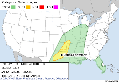
The SPC forecast included a slight risk of storms over the DFW TRACON area.
Here is the CCFP issued at 17Z, valid at 19Z.
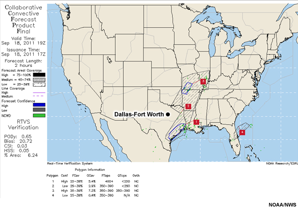
Here is the CWSU forecast issued at 19Z, valid for 00Z.
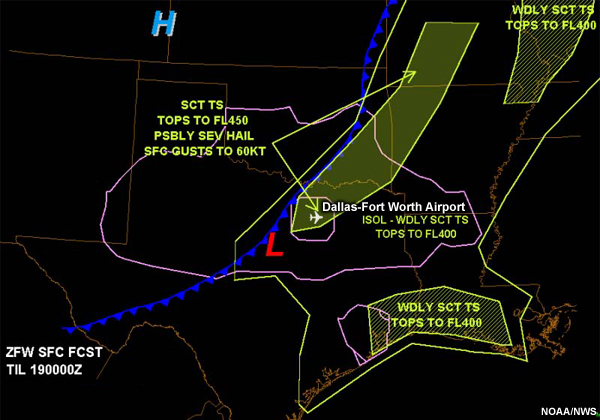
The CWSU forecast issued 19z, valid for 00z, indicated scattered thunderstorms over the airport and the northeast area of the TRACON. On the CWSU product, the scattered thunderstorms are equivalent to 40-74% coverage on a CCFP.
Question 1
Compare these forecasts. What weather threat would you anticipate for the Dallas-Fort Worth airspace? (Choose the best answer.)
The correct answer is c).
In the CCFP, the Dallas-Fort Worth airport is just outside the forecast areal coverage for significant thunderstorms. The CCFP forecaster had the storm potential located more north and east of the DFW TRACON area. The CWSU forecasted scattered thunderstorms with possible severe hail and wind gusts to 60 KT for an area including the DFW and DAL airports. Based on CAPE, KI, and other indicators, the CWSU forecaster extended the thunderstorm area south and west so that it covered the DFW TRACON area.
Question 2
If you were an air traffic manager for the Dallas-Fort Worth Airport, which forecast would you prepare for? (Choose the best answer.)
The correct answer is c).
In this situation, it is difficult to prepare for potential impacts when forecasts offer differing information. Forecasting for a single point is one of the most difficult tasks in meteorology, yet aviation users depend on this level of precision and plan accordingly. Weather forecasts always have some degree of uncertainty and sometimes more time is needed to clarify how conditions are evolving. As you know, aviation partners often need to make Yes/No decisions at certain times and uncertainties or inconsistent messages complicate their decision-making. The 17Z CCFP didnt include the DFW airport in its threat area, so based on that product the ATCSCC would not anticipate problems for inbound flights. The 19Z CWSU forecast issued two hours later alerted managers of the potential for problems.
In this situation, the traffic managers felt confident in the CWSU forecast because of the good long-term relationship between the organizations. There are times when the national level CCFP product cannot capture all local impacts that might develop. Here, the Dallas-Fort Worth CWSU forecasters built on the work of the CCFP and targeted the forecast to the unique needs of the users in their location.
The 21Z CCFP valid for 01Z included the 18Z model runs and had an expanded area of coverage with higher confidence. This new area included the DFW airport. This case highlights the importance of consistency across all weather products even in challenging forecast situations. Whether in a WFO, CWSU, or national center, carefully considering both large-scale and local points of view and working to achieve a consistent message is necessary for providing the most useful information for your aviation partners. Integrating these viewpoints through coordination and collaboration between the regional and national meteorologists can help ensure that a consistent message is being passed on to aviation decision-makers.
Understand User Needs
Question 1
Given the probability of convective activity, what key points must be included in the forecast products to assist aviation users in their planning? (Choose the best answer.)
The correct answer is c).
Aviation users need to know the onset and duration of the event, the type of precipitation, the intensity, as well as the ceiling and visibility values throughout the event. The other options include valuable information but are incomplete.
Question 2
Which of the following forecasts contains the elements that need to be included? (Choose the best answer.)
The correct answer is c).
This forecast provides the key elements, including event arrival, duration, precipitation type, intensity, and ceiling and visibility values. Based on the anticipated thunderstorm activity, the CWSU expected disruptions to the northeast and east gates beginning around 21Z (4:00 p.m. CDT).
Here is the gate forecast issued at 00Z.
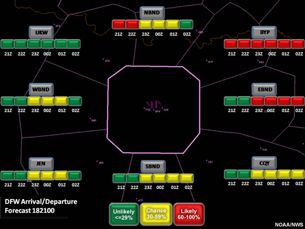
The forecast for the TRACON indicated the likelihood of thunderstorms from 0-2Z (7-9 p.m.).
Question 3
Based on this forecast, what would be the major concern for the FAA? (Choose all that apply.)
The correct answers are b) and e).
Rerouting traffic to different gates would be the major challenge. Thunderstorms can close off a gate and require flights to follow other arrival or departure routes. In a worst-case scenario, flights might be diverted to other airports. Theyll then need to refuel and wait for clearance to the original airport to get passengers and equipment to their destination. To avoid that situation, traffic managers will want to plan strategically and tactically to route traffic around the threatened areas.
Backgrounder: Rerouting
If the volume of traffic coming in through a particular gate is already high, or if that gate is affected by weather, traffic will need to be rerouted to other gates. In this process, the rerouted arrival traffic may have to fly under departing traffic. This procedure is called "tunneling" and is often used to avoid conflicting flows of traffic and holding patterns around busy airports. Tunneling works well for mitigating weather impacts when it can be planned ahead of time. These procedures require close collaboration, as operational errors can become more likely when arrival reroutes and tunneling occur.
When weather blocks an approach or departure gate, Traffic Management Coordinators can shut off that gate to all traffic and re-assign the traffic through another gate. This procedure is called a gate swap. It may be implemented in coordination with other traffic management activities, including holding traffic, increasing separation, or assigning the aircraft lower speeds so that TRACON or Tower controllers have more time to work with them.
Question
Resuming normal operations as soon as it is safe to do so will be a high priority for your aviation partners. But how might traffic coordinators determine when the impact of a weather disruption is over? (Choose all that apply.)
The correct answers are a) and b).
Radar observations can usually indicate when thunderstorms are clearing a gate, but it's still difficult to decide when to recommend sending traffic back through the gate. Typically, the TRACON, tower, en route facility, meteorologists, and the airlines will coordinate to make a decision to reopen a gate.
Anticipate the Impacts
Question
For the Dallas-Fort Worth case, what do you think would be the major impacts to aviation interests as thunderstorms developed? (Choose all that apply.)
The correct answers are b), c), and d).
In total, traffic managers dealt with the impacts of this weather system for nearly six hours. They rerouted traffic around the storm and kept aircraft holding while the storm moved directly over the airport. These actions delayed flight arrival times and spent extra aircraft fuel. Some aircraft needed to be diverted to alternate airports. When these diversions occur, the traffic managers must then deal with “recovery”—getting the diverted planes and their passengers back to their original destinations.
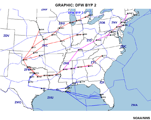
Given a three-hour lead time on the thunderstorm threat, the DFW traffic managers advised the ATCSCC that a BYP 2 Playbook would be in order. This Playbook Route moves flights approaching and departing the DFW TRACON to the south and west gates, as the north and east gates would likely be shut off due to weather. The three-hour lead time allowed traffic to be managed proactively and helped defuse some of the problems associated with closing off a major part of the airspace.
Even with the three-hour lead time, a number of flights already en route to Dallas were forced to hold because of the weather in the east part of the TRACON, and about 30-35 flights needed to be diverted. But if changes to the traffic management plan had not been implemented with the three-hour lead time, the effects would have been much worse, possibly forcing the diversion of ~300 flights. The effects of the convective activity on inbound flights can be seen here.
This animation begins at ~1826Z (1:26 p.m.). Operations proceed normally even around 2030Z (3:30 p.m.) when the first convective activity (illustrated by the yellow lightning symbols) develops along the east and northeast gates. By 2146Z (4:46 p.m.), planes begin holding as they converge on the airport after being routed around scattered storms near the northeast gate. By 0030Z (7:30 p.m.), the northeast gate is completely shut off. As the line of thunderstorms moves over the airport around 0130Z, the holding for DFW TRACON becomes pronounced. AAR does not pick up again until about 0255Z (9:55 p.m.). By that time, the storms had moved out, toward the southeast. However, only the northwest and southwest gates were available to the remaining incoming traffic.
This was a case where local expertise and familiarity with local area was essential. The local traffic managers listened to the local CWSU and used their input in the decision making. In this case, the local insight overrode the initial guidance provided by CCFP. These differences in products reflect the differences between developing forecasts at national and local scales: in any forecast situation, all efforts should be made to ensure consistency.
Traffic managers trusted the local expertise because of their history of working together and the relationships that have been built. When weather is going to affect planes or ground operations, it's essential that CWSU forecasters understand the mindset of the controller to be able to communicate the impacts and provide the best possible products. In these situations, having seasoned forecasters who understand the area, traffic management concerns, and can talk in air traffic language is imperative.
Backgrounder: Severe Weather Avoidance Program
Large weather systems can impede traffic along a route so that not all aircraft can get through safely, causing an ARTCC to implement a Severe Weather Avoidance Program (SWAP). In these situations, most aircraft will be given an alternate route to get around the weather. Each flight entering the blocked route is redirected by a controller to the next one or two navigational points, and the pilot is asked for an updated flight plan. SWAPs are regionally dependent (not all ARTCCs may do them) and are issued via route advisories by the ATCSCC as part of the overall daily operations plan. These plans should not be confused with the gate swap procedure used for approaches and departures.
Question
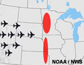
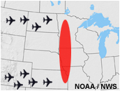
Suppose we put ourselves in the shoes of the Minneapolis Center (ZMP) traffic management coordinators. The figure above depicts a line of thunderstorms across Minneapolis Center and the surrounding area. The line has a hole, a common occurrence with squall lines, but it is forecast to fill in over the next two hours. What plans would the traffic management coordinators have in place to address the present and expected situations? (Choose all that apply.)
The correct answers are b) and c).
With a good forecast, traffic management coordinators will know ahead of time that a large system could impact a part of the airspace. As the line begins to develop, they will allow some aircraft to move through areas where activity is not yet occurring, particularly when the opening is large (50 or more miles). To help assess conditions in these openings, the TRACON might request a "pathfinder." A pathfinder volunteers (depending on the aircraft's equipment, captain qualifications, and other factors) to look for an acceptable route. The aircraft is sent through and given ample space to maneuver around a hazard if necessary, and if their report is favorable, more traffic may be directed through the opening in the line.
Other aircraft will be assigned a new route to avoid the squall line. This way, as the storms fill in, the aircraft will be positioned to avoid the squall line.