Overview
This case presents a precipitation type forecasting challenge over New Brunswick, Canada. The time period is from 01-03 February, 2003. As a winter storm moves into the area, you'll be asked to look at various observations and model data in order to forecast precipitation type and issue any severe winter weather warnings. You'll be looking at NWP precipitation type forecasts, applying partial thickness analysis to model data, and making use of the top-down Method for forecasting precipitation type.
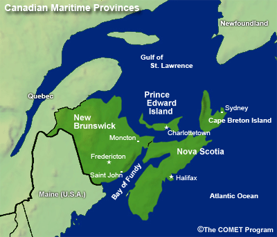
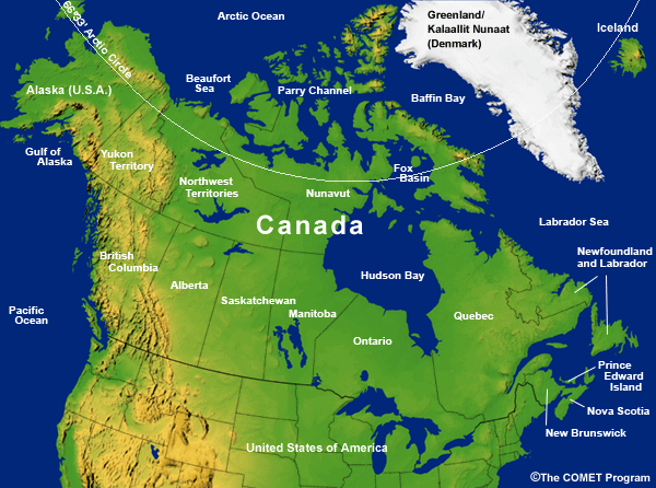
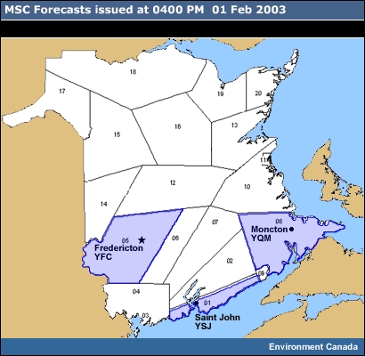
Geographic Location : Canadian Maritime Provinces - New Brunswick
Case Time Frame: 1200 UTC 0l February 2003 - 0000 UTC 03 February
Phenomenon of Interest: Precipitation Type
Forecasting Challenges:
- Understand the limitations of NWP models in precipitation type forecasts.
- Apply partial thickness analysis for forecasting precipitation type.
- Apply the top-down Method for forecasting precipitation type.
Geographic Setting: The Maritime Provinces
The setting for this case is the Maritime Provinces which includes the Provinces of New Brunswick, Nova Scotia and Prince Edward Island, all bordering the Atlantic Ocean. They have a combined population of close to 2 million people with the major population centers being Saint John, Moncton, and Fredericton in New Brunswick, Halifax and Sydney in Nova Scotia, and Charlottetown in Prince Edward Island. The primary industries are forestry, agriculture, fishing, and tourism. All of these are highly weather dependent.
Although the event in this case exercise also affected parts of Nova Scotia and Prince Edward Island, we'll be focusing on the Province of New Brunswick.
Marine Influences
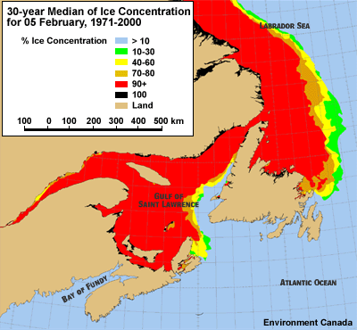
The marine influences of the Gulf of St. Lawrence and the Bay of Fundy play an important role in the mesoscale meteorology along the eastern and southern coasts of New Brunswick. Normally the shallower Gulf of St. Lawrence is almost completely ice-covered by February, while the deep-water Bay of Fundy, home of the world's highest tides, remains ice free throughout the winter. Sea surface temperatures in the Bay are generally in the 1-3ºC range this time of year. Southerly winds blowing across the Bay can warm the lowest levels of the atmosphere to produce an above freezing surface layer along the coastal zone.
Terrain
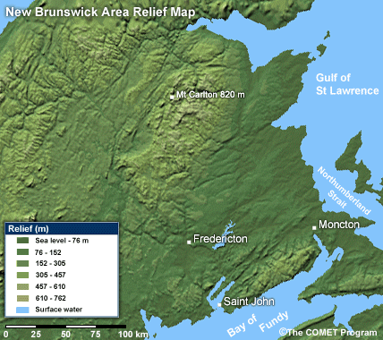
Most of the prominent physical features of New Brunswick are aligned in southwest-to-northeast. The highest terrain in the Province is the continuation of the Appalachian Range, which includes the highest point in the Maritime Provinces: Mount Carleton at 820 m (2690 ft). The uplands aligned along the eastern Bay of Fundy coast have elevations ranging from about 305 to 425 m (1000 to 1400 ft). The Maritime Plain, a triangular region with its base along the Northumberland Strait, covers about one-third of the province. This region is flat to gently rolling hills and lies mostly below 150 m (500 ft) in elevation.
Forecasting in New Brunswick
Forecasts for New Brunswick at the time of this case study were issued from the New Brunswick Weather Services Office (NBWSO) located in Fredericton. Since July 2004, forecasts for the whole of the Canadian Atlantic Provinces—the three Maritime Provinces plus Newfoundland and Labrador—have been issued from the Atlantic Storm Prediction Centre in Dartmouth, Nova Scotia.
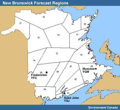
Regular public forecasts are issued at 0500, 1100, and 1600 Atlantic Standard Time (AST, which is UTC minus 4 hours) with amendments issued as necessary. The public forecasts are prepared in a county-by-county format. But this case exercise we'll be concentrating on forecasts for the major population centres of Saint John (YSJ), Fredericton (YFC), and Moncton (YQM).
Severe Weather Warning Thresholds and NWP Models
Weather Warning Bulletins for severe winter weather are issued as far in advance as confidence allows. The criteria used for issuing the relevant warnings for this case are:
| Precipitation Types and MSC Warning Criteria | |
| Precipitation Type | Warning Criteria |
| Heavy Snowfall | 15 cm or more in a 24-hour period |
| Heavy Winter Rainfall (winter with frozen ground) | 25 mm in a 12-hour period |
| Freezing Rain | 4 hours or more of continuous freezing rain A warning can be issued for shorter duration events if public safety is a concern. |
| Freezing Drizzle | 7 hours or more in duration |
The Canadian GEM Regional Model is the primary NWP forecast tool. It is run twice daily at 0000 and 1200 UTC. This model is the input for SCRIBE, an automated weather elements and forecast product generator. Forecasters have access to other numerical model output either via the Internet or directly from the Canadian Meteorological Centre (CMC) in Montreal. For this exercise, output from the GEM Regional and the U.S. Eta Model will be used.
* For detailed information on the models, please see Operational Models Encyclopedia.
The Case Challenge
Current time: 1130 UTC 01 Feb 2003
The Case Challenge consists of a series of forecast questions that you would most likely be asking yourself at the forecast desk. The first set of questions focuses on precipitation type in the forecast for Saturday, 01 February 2003. The remainder will concentrate on the potential winter storm predicted to move into New Brunswick overnight Saturday and into Sunday, 02 February.
We'll take the perspective of a forecaster at the New Brunswick Weather Services Office in Fredericton, just starting what looks to be a busy 12-hour shift. It's 0730 AST (1130 UTC) on 01 February. During the briefing, the departing night shift forecaster mentioned that you may need to consider putting out a freezing rain warning for southern New Brunswick. Light freezing rain has been falling in Saint John for almost 4 hours. You'll need to make a quick decision on this. Take a look at the last official forecast and the current observations and synoptic conditions.
| Available Data | |
| Model Output | Observations and Forecasts |
|
GEM
Regional and Eta Loops GEM Regional and Eta 48 hr fcst initialized 0000 UTC 01 Feb 2003 (MSLP, 500 hPa heights) |
Station Observations
0600-1120 UTC 01 Feb 2003 for Fredericton, Moncton, and Saint John Issued Forecasts Satellite Loop |
Question 1: Synoptic Setting and Current Issues
Current time: 1130 UTC 01 Feb 2003
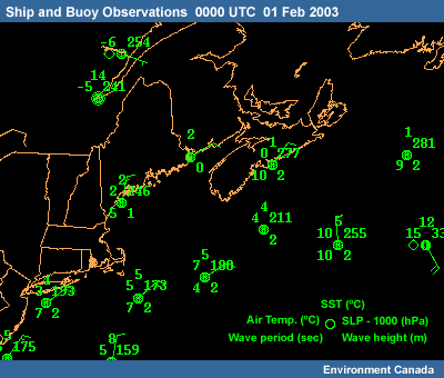
The immediate forecast problem is the precipitation currently falling over extreme southern New Brunswick as can be seen in the Saint John and Moncton observations.
| Precipitation Types and MSC Warning Criteria | |
| Precipitation Type | Warning Criteria |
| Heavy Snowfall | 15 cm or more in a 24-hour period (assuming a 10:1 snow/rain ratio) |
| Heavy Winter Rainfall (winter with frozen ground) | 25 mm in a 12-hour period |
| Freezing Rain | 4 hours or more of continuous freezing rain A warning can be issued for shorter duration events if public safety is a concern. |
| Freezing Drizzle | 7 hours or more in duration |
After considering the surface observations, model, and satellite data, which course of action would you take for the Saint John region? See the Precipitation Types and MSC Warning Criteria in the Supporting Topics for warning criteria.
The correct answer is: Take no action.
The best thing to do is to take no action. It's apparent from the satellite loop that the freezing rain will soon end in Saint John as the area of precipitation moves to the northeast. The forecast currently in effect for this area covers the situation just fine.
FORECASTS FOR NEW BRUNSWICK ISSUED BY THE NEW BRUNSWICK WEATHER
CENTRE OF ENVIRONMENT CANADA AT 5:00 AM AST SATURDAY 1 FEBRUARY 2003 FOR TODAY AND SUNDAY.
THE NEXT SCHEDULED FORECAST WILL BE ISSUED AT 11:00 AM
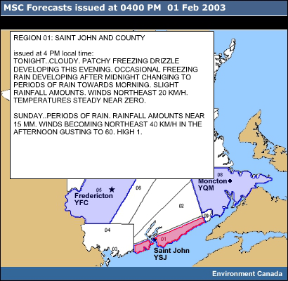
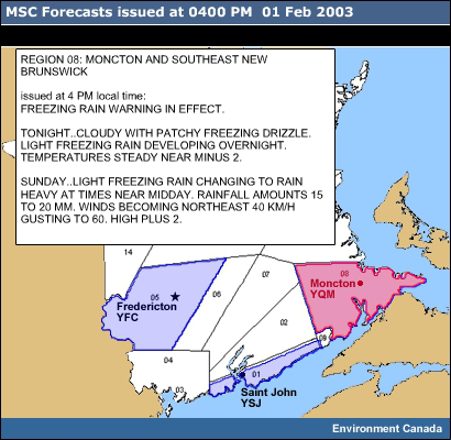
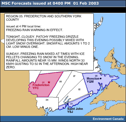
REGION 01: SAINT JOHN AND COUNTY TODAY..CLOUDY WITH OCCASIONAL FREEZING RAIN AT FIRST GIVING A FEW MM. BECOMING A MIX OF SUN AND CLOUD NEAR MIDDAY. WINDS NORTHEAST
20 KM/H. HIGH PLUS ONE. TONIGHT..BECOMING MAINLY CLOUDY. WINDS NORTHEAST 30 KM/H.
LOW MINUS 4.
SUNDAY..CLOUDY WITH ICE PELLETS POSSIBLY MIXED WITH FREEZING RAIN
DEVELOPING IN THE MORNING CHANGING TO PERIODS OF SNOW LATE IN THE
AFTERNOON. SNOWFALL AMOUNTS NEAR 5 CM. WINDS INCREASING TO NORTH
40 KM/H GUSTING TO 60 GIVING OCCASIONALLY POOR VISIBILITY IN BLOWING
SNOW LATE IN THE DAY. HIGH MINUS 2.
| Available Data | |
| Model Output | Observations and Forecasts |
|
GEM
Regional and Eta Loops GEM Regional and Eta 48 hr fcst initialized 0000 UTC 01 Feb 2003 (MSLP, 500 hPa heights) |
Station Observations
0600-1120 UTC 01 Feb 2003 for Fredericton, Moncton, and Saint John Issued Forecasts Satellite Loop |
| Supporting Topics |
|
Ten Common NWP Misconceptions: NWP Models Directly Forecast
Near-Surface Variables |
Question 2: Precipitation Type for Moncton, 12-hour Forecast valid 1200 UTC
Current time: 1130 UTC 01 Feb 2003
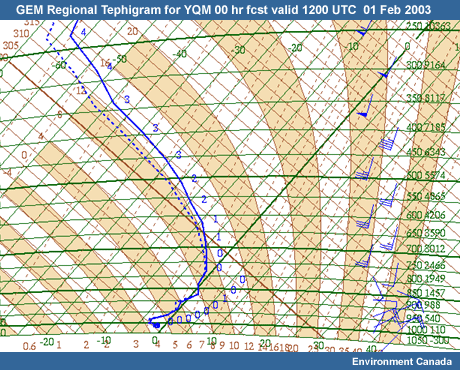
Now let's turn our attention to the forecast for Moncton. Take a look at the 12-hour forecast tephigram from the GEM Regional model for Moncton (YQM) valid for 1200 UTC on 01 February. We'll be using forecast tephigrams throughout this case since there are no representative upper-air stations available in the area. Since we are also relying on model data for much of the case, it's important to keep some of the NWP limitations in mind as you proceed. In particular, the limitations of near-surface variables may be a factor to consider (see Ten Common NWP Misconceptions: NWP Models Directly Forecast Near-Surface Variables).
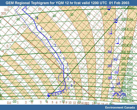
Does this sounding suggest the presence of ice crystals in the cloud?
The correct answer is: Yes
The sounding does show the potential for the presence of ice crystals in the clouds, and the tephigram shows a substantial layer close to saturation and below -10ºC. So conditions in the upper part of the environmental curve are favourable for ice crystal formation.
| Available Data | |
| Model Output | Observations and Forecasts |
|
|
Station Observations
0600-1120 UTC 01 Feb 2003 for Fredericton, Moncton, and Saint John Issued Forecasts |
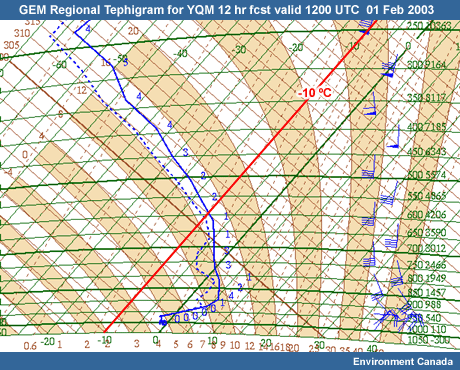
Question 3: Precipitation Type for Moncton, 12-hour Forecast valid 1200 UTC
Current time: 1130 UTC 01 Feb 2003
Now consider the elevated warm layer in the sounding between 950 and 780 hPa.
Are the temperature and/or depth of the elevated warm layer sufficient to melt the ice particles?
The correct answers are: Yes and Freezing rain
In the forecast tephigram, the elevated warm layer is deep enough and, at 5ºC, warm enough to melt any falling ice crystals. Empirical studies have shown an almost linear relationship between the depth of the above-freezing layer and the maximum temperature of the layer:
- With a maximum temperature of 1ºC or less it will not be warm enough to melt the snow/ice, so no precipitation change will result.
- With a maximum temperature between 1 and 3ºC, the snow/ice will not melt completely. Due to the presence of ice particles, the liquid drops will immediately refreeze in the cold surface layer resulting in ice pellets if the temperature is near 3ºC, or a mix of snow and ice pellets and freezing rain with temperatures near 1-2ºC.
- With a maximum temperature greater than 3ºC it will cause the snow/ice to completely melt resulting in freezing rain if the surface temperature is below 0ºC.
Freezing rain is a definite possibility according to the model forecast sounding. The freezing layer near the surface is too shallow to refreeze any droplets falling to the ground. It is however cold enough to cause freezing on contact when the droplets hit the ground or other objects at the surface with a temperature of less than 0ºC.
Take note of the observations for Moncton at 0800 AST (1200 UTC), the time of the model forecast. The station is reporting snow and it has been snowing for over 4 hours. It looks like the 0000 UTC GEM Regional model run is predicting a warmer layer between 950 and 780 hPa than what's being observed.
← Previous Question Next Question →
| Available Data | |
| Model Output | Observations and Forecasts |
|
|
Station Observations
0600-1400 UTC 01 Feb 2003 for Fredericton, Moncton, and Saint John Issued Forecasts |
| Supporting Topics | |
| Microphysics: The Ice Crystal Process |
Question 4: Precipitation Type for Moncton, 00-hour Forecast valid 1200 UTC
Moving forward in time, it's now a little after 1000 AST and the 1200 UTC model runs are available. Updated forecasts are due shortly, at 1100 AST.
Based on the discrepancy between observed and model data for Moncton at 1200 UTC, the first thing you want to do is compare the GEM Regional Model's initial analysis with the previous 12-hour forecast. Compare the 00-hour forecast tephigram for 1200 UTC with the previous 12-hour forecast.
What type of precipitation does the 00-hour sounding suggest for YQM at 1200 UTC?
The correct answer is: Snow
The sounding indicates snow. The warm-layer maximum temperature and thickness are both considerably reduced in the 00-hour analysis and more in line with observations in Moncton. Very little melting of ice crystals could take place as they fall through this environment. Loss of sensible heat in the melting process would quickly cool the surrounding air and further reduce the thickness of the shallow elevated warm layer.
| Available Data | |
| Model Output | Observations and Forecasts |
|
GEM
Regional and Eta Loops GEM Regional and Eta 48 hr fcst initialized 1200 UTC 01 Feb 2003 (MSLP) |
Station Observations
0600-1400 UTC 01 Feb 2003 for
Fredericton, Moncton, and Saint John |
| Supporting Topics | |
| Microphysics: The Ice Crystal Process |
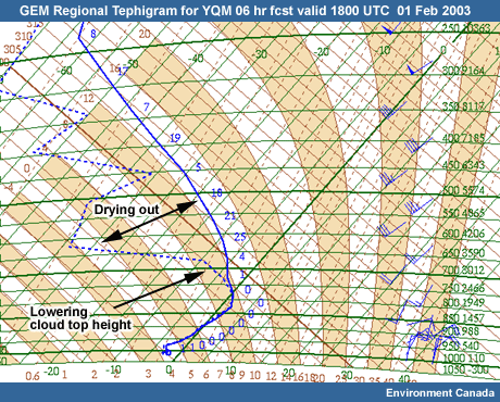
Question 5: Precipitation Type for Moncton, 06-hour Forecast valid 1800 UTC
Current time: 1415 UTC 01 Feb 2003
With updating the forecast in mind, take a look at the 06-hour forecast tephigram valid at 1800 UTC.
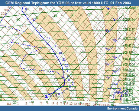
What's the most significant difference between 1200 and 1800 UTC that may impact precipitation type?
The correct answers are: Drying out of air mass at upper levels and Freezing drizzle
The first thing to note is the drying out of the air mass at upper levels. This will lead to warmer cloud-top temperatures. The model tephigram is predicting them to be around -5ºC. That's not cold enough for ice formation in the cloud.
There are also indications of a wind shift around the cloud level. This could cause enough turbulence for droplets to grow by the coalescence process, but it doesn't look like the cloud depth will be large enough to allow rain drop size growth.
Based on the forecasted cloud-top temperatures, the shallow depth of the clouds, and the continued presence of a saturated below-freezing layer near the surface, your forecast should call for freezing drizzle.
| Available Data | |
| Model Output | Observations and Forecasts |
|
GEM
Regional and Eta Loops GEM Regional and Eta 48 hr fcst initialized 1200 UTC 01 Feb 2003 (MSLP) |
Station Observations
0600-1400 UTC 01 Feb 2003 for
Fredericton, Moncton, and Saint John |
| Supporting Topics | |
| Microphysics: The Ice Crystal Process |
Question 6: Mesoscale Processes and Precipitation Type
Current time: 1415 UTC 01 Feb 2003
Now considering mesoscale processes in this situation, what factors would suggest that freezing drizzle will continue to fall in the Moncton area?
The correct answer is: All of the above.
All of the above should play a factor in freezing drizzle continuing to fall in the Moncton area for the next 6 hours. The low-level northeasterly flow off of the frozen Gulf of St. Lawrence and the existing snow coverage will continue to keep the surface layer below freezing. The terrain-induced uplift should continue to enhance cooling and condensation in the near surface layer, which is already responsible for producing the freezing drizzle.
← Previous QuestionMethods for Forecasting Precipitation Type
Current time: 1500 UTC 01 Feb 2003
We've moved forward in time a bit, and it's now 1100 AST (1500 UTC). The forecast updates have been sent out, but there wasn't enough time to incorporate changes to the forecast for tonight or for the Sunday time period. You now have to assess the model outputs for the 1200 UTC run and, using the various tools and techniques available to you, decide what type of precipitation type warnings, if any, will need to be issued for Saint John (YSJ), Fredericton (YFC), and Moncton (YQM) for tonight and tomorrow.
We'll first take a look at the model analysis for precipitation type and then compare that to two diagnostic methods: partial thickness analysis and the "top-down Method."
Comparing Precipitation Type and QPF in the Models
Current time: 1500 UTC 01 Feb 2003
Now let's consider the GEM and Eta 6-hour precipitation forecasts for 1200 UTC on 02 February. Compare the two model forecasts for that time point. It's obvious that the Eta is bringing precipitation in much faster than the GEM. The Eta is indicating that by 1200 UTC, Fredericton (YFC), and Saint John (YSJ) will have received 9-12 mm with Moncton (YQM) receiving 6-9 mm. The GEM is indicating only 1-3 mm for Fredericton and Saint John and the precipitation hasn't started in Moncton
In terms of precipitation type both models are indicating freezing rain for Fredericton at 1200 UTC and both have the rain/freezing rain boundary close to Saint John. The Eta is predicting freezing rain for Moncton as well.
By 1800 UTC the precipitation type charts for both models have a similar pattern. But the Eta is indicating a changeover to freezing rain much farther to the north than the GEM. Going with the Eta all three stations are indicating rain at 1800 UTC with pockets of freezing rain close to Fredericton. The GEM is indicating rain for Saint John, freezing rain/ice pellets (sleet) for Fredericton, with Moncton close to the rain/freezing rain changeover.
| Available Data | |
| Model Output | Observations and Forecasts |
|
GEM Regional and Eta Loops GEM Regional and Eta Precipitation Type
Forecast |
|
Question 9: Precipitation Type Based on Model Forecast
Current time: 1500 UTC 01 Feb 2003
Now consider the 36-hour precipitation type forecasts more closely. Both model patterns are similar. Looking at the GEM Regional, ice pellets are indicated close to Saint John (YSJ) and Fredericton (YFC) with rain in Moncton (YQM). The Eta is indicating a mix of rain and freezing rain near Saint John and Fredericton with rain near Moncton.
Look at the other time points and complete the table with precipitation types based on the model charts.
| GEM Regional and Eta 6-hourly Interpolated
QPF Values and Precipitation Type 18, 24, 30, and 36-hour forecasts valid 0600-0000 UTC 02-03 Feb 2003 |
||||||||
| 06 UTC | 12 UTC | 18 UTC | 00 UTC | max. rain in 12 hours (mm) | max. snow in 12 hours (mm) | |||
|
G
E M |
Saint John YSJ | precipitation type | none | |||||
|
6 hr precipitation (mm)
|
0
|
2
|
12
|
2
|
14
|
140
|
||
| Fredericton YFC | precipitation type | none | ||||||
|
6 hr precipitation
(mm)
|
0
|
2
|
10
|
5
|
15
|
170
|
||
| Moncton YQM | precipitation type | none | ||||||
|
6 hr precipitation
(mm)
|
0
|
0
|
11
|
5
|
16
|
160
|
||
|
E
T A |
Saint John YSJ | precipitation type | none | |||||
| 6 hr precipitation (mm) |
0
|
12
|
12
|
0
|
24
|
240
|
||
| Fredericton YFC | precipitation type | none | ||||||
| 6 hr precipitation (mm) |
0
|
10
|
14
|
0
|
24
|
240
|
||
| Moncton YQM | precipitation type | none | ||||||
| 6 hr precipitation (mm) |
0
|
7
|
14
|
3
|
21
|
240
|
||
| Legend: Rain=R, Snow=S, Rain and Snow=RS, Drizzle=L, Freezing Drizzle=LZ, Freezing Rain=ZR, Ice Pellets (sleet)=IP | ||||||||
Considering these values, including the 6-hour precipitation totals, what, if any, warnings should be issued for each site?
Discussion:
Based on model precipitation type analysis and QPF charts, the following warnings are warranted:
| Precipitation Type Warnings for the 1600
AST/2000 UTC Forecast Forecast Based on Model Data for 24-hour time period beginning 12 UTC 02 Feb 2003 |
|||||||
| Heavy Rain | Heavy Snow | Freezing Rain | Freezing Drizzle | ||||
| Saint John YSJ | possibly | no | no | no | |||
| Fredericton YFC | no | no | yes | no | |||
| Moncton YQM | no | no | yes | no | |||
|
* see the Supporting Topic:
Precipitation Types and MSC Warning
Criteria
|
|||||||
Saint John (YSJ)
Both the GEM Regional and
Eta models indicate a quick changeover to rain. Given the onshore
winds from the open water of the Bay of Fundy, a prolonged period of
freezing rain would be unlikely at Saint John. The only warning that
may be warranted at this stage would be a heavy winter rainfall
warning.
Fredericton (YFC)
By 0600 UTC on 02 February,
the Eta 6-hour QPF is already forecasting precipitation over western
New Brunswick. Given that the Eta's rain/freezing rain boundary is
well north of YFC at 1200 UTC, it's likely that the site will
receive at least 4 hours of freezing rain by 1200 UTC. The GEM
regional precipitation type charts are also indicating freezing at
1200 and 1800 UTC with possibly a change to ice pellets by 1800 UTC.
Both models, despite their differences in timing, warrant a freezing
rain warning for Fredericton.
Moncton (YQM)
The GEM Regional precipitation
and QPF charts indicate that the precipitation would likely begin
within 2 hours of 1200 UTC. The 1800 UTC precipitation type chart
indicates freezing rain, while the 0000 UTC indicates a changeover
to rain is likely within a couple hours of 0000 UTC. The probability
of a 4-hour period of freezing rain within this 12-hour period is
high. The Eta model brings the precipitation into Moncton much
earlier and is indicating freezing rain at 1200 UTC, with rain at
1800 UTC. The probability of a 4-hour period of freezing rain is
high. So both models justify issuing a freezing rain warning for
Moncton.
Next Question →
| Available Data | |
| Model Output | Observations and Forecasts |
|
GEM Regional and Eta Loops GEM Regional and Eta Precipitation Type
Forecast |
|
| Supporting Topics | |
| Empirical Methods: Partial Thickness
Analysis Empirical Methods: Top-Down Method |
Question 10: Precipitation Type Based on Partial Thickness Method
Current time: 1500 UTC 01 Feb 2003
Having looked at the model precipitation type forecasts, let's turn to the partial thickness method and see how it compares. There is a detailed overview of the method in the Supporting Topics, including nomograms for the Maritime region.
Take a look at the 850-700 and 1000-850 hPa partial thicknesses. These are the most appropriate thicknesses to look at for the Atlantic Region. Based on the charts and the nomograms, determine the precipitation type forecast for 1200 UTC for the three stations. The 1800 and 0000 UTC times have been done for you. Then, if warranted, update the forecast warnings.
Discussion:
Using the partial thickness Method and the nomograms for Atlantic Canada, the precipitation type forecasts for the three stations show the following:
| GEM Regional | Eta | Warnings | |||||
| 12 UTC | 18 UTC | 00 UTC | 12 UTC | 18 UTC | 00 UTC | ||
| Saint John YSJ | ZR | ZR | ZR | R | R | ZR | Heavy Winter Rainfall |
| Fredericton YFC | R | R or ZR | R or ZR | R | R | R | Freezing Rain |
| Moncton YQM | R or ZR | R or ZR | R or ZR | R | R | R | Freezing Rain |
| Legend: Rain=R, Snow=S, Rain and Snow=RS, Drizzle=L, Freezing Drizzle=LZ, Freezing Rain=ZR, Ice Pellets (sleet)=IP | |||||||
Using this method, there is a big difference between the precipitation types predicted by the Eta versus the GEM Regional models. The Eta model is predicting this to be predominantly a rainfall event except at Saint John later in the period. Using just the precipitation type charts, there was much better agreement between the two models.
It's apparent that the partial thickness method, at least for the Eta model data, is predicting a predominantly rain event. Take a look at the 24-hour Eta Prog Skew-T for Fredericton valid 1200 UTC on 02 February. This sounding displays an inherent weakness in the partial thickness method. The 1000-850 hPa thickness is "warm" due to the significant above-freezing layer. But the near-surface layer is still at or below freezing. The snow covered surface will act to "prolong the life" of the below-freezing surface layer. This will also be true at Moncton as long as the low-level winds are blowing from the ice covered Gulf of St. Lawrence. Other mesoscale features such as cold air drainage into valleys can also perpetuate below-freezing surface layers and significant freezing rainfall events.
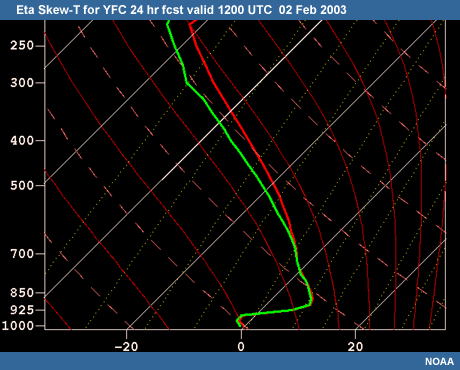
The Baldwin Technique used in the Eta Model precipitation typing will always predict freezing rain if the near surface layer is below freezing.
← Previous Question Next Question →| Available Data | |
| Model Output | Observations and Forecasts |
|
GEM Regional and Eta Vertical Profiles for
YSJ, YFC, YQM GEM Regional and Eta Loops GEM Regional and Eta Precipitation Type
Forecast |
|
| Supporting Topics | |
|
Empirical Methods: Partial Thickness
Analysis |
Question 11: Precipitation Type Based on the "Top-Down"
Current time: 1500 UTC 01 Feb 2003
Now let's turn to the "top-down" method and see how it compares. Again, there's a detailed overview of this method in the Supporting Topics.
Using the top-down method, analyze the soundings for the three stations using the GEM Regional tephigrams and Eta skew-Ts for the 1200 UTC run on 01 February. Determine the precipitation type forecast and modify your warnings accordingly.
Discussion:
The Top-Down Method with the GEM Regional tephigrams and the Eta skew-Ts, indicates the following precipitation types for the time periods:
| GEM Regional | Eta | Warnings |
|||||
| 12 UTC | 18 UTC | 00 UTC | 12 UTC | 18 UTC | 00 UTC | ||
| Saint John YSJ | R or ZR | L | L | R | R | R | Heavy Winter Rainfall |
| Fredericton YFC | S or IP | ZR | ZL | ZR | R | R or IP | Freezing Rain |
| Moncton YQM | ZR | R | L | R or IP | R | L | Freezing Rain |
| Legend: Rain=R, Snow=S, Rain and Snow=RS, Drizzle=L, Freezing Drizzle=LZ, Freezing Rain=ZR, Ice Pellets (sleet)=IP | |||||||
The top-down method is in better agreement with the post-processed model precipitation types than the partial thickness method. This is by far a more robust empirical method. It takes into account the presence of ice nuclei and the thermal energy in the melting and refreezing layers.
← Previous Question Next Question →
| Available Data | |
| Model Output | Observations and Forecasts |
|
GEM Regional and Eta Vertical Profiles for
YSJ, YFC, YQM GEM Regional and Eta Loops GEM Regional and Eta Precipitation Type
Forecast |
|
| Supporting Topics | |
| Empirical Methods: Partial Thickness
Analysis Empirical Methods: Top-Down Method |
Question 12: Final Forecast Warnings
You've now assessed the precipitation type using three methods:
1. Post-processed model precipitation type guidance
2. Partial
thickness correlation
3. Top-down soundings analysis
Based on your findings, you should be ready to issue (or not) a proper set of warnings for the three stations. Give the warning(s) you would issue in the 1600 AST (2000 UTC) forecast relevant for the 24-hour time period beginning 1200 UTC on 02 February.
Discussion:
Compare your warnings to the warnings and forecasts issued by the forecast office at 1600 AST/2000 UTC on 01 February:
← Previous Question
Summary
The main purpose behind this exercise was to demonstrate the various techniques for forecasting precipitation type in an operational setting. Obviously, as the event draws closer and new model runs become available, the forecasts and warnings will be further refined. The warnings for this exercise were based on the critical period 12-24 hours before the onset of the storm. At least this much notice is required for various stakeholders (e.g., power companies and road departments) to take effective action in order to minimize the hazards associated with a freezing storm.


Verification
So how accurate were the warnings and forecasts? Take a look at the Eta 00-hour forecasts for 02 February and 0000 UTC on 03 February. We'll use the Eta's 00-hour prognosis as a rough equivalent to observations.
Eta 00-hour
Forecasts
Eta 00 hr fcsts initialized at 00, 06, 12, 18, 00 UTC 02-03 Feb
2003
Eta 00-hour Forecast
Skew-Ts
Eta 00 hr fcsts initialized at 00, 06, 12, 18, 00 UTC 02-03 Feb
2003
It should be noted that the GEM and Eta 0000 UTC 02 February model runs significantly increased the forecast QPF values (not shown in the loops here). They were in excess of 30 mm for the period 0600 through 0000 UTC on 02 to 03 February for all three stations. And more than 25 mm for the 12-hour period beginning at 1200 UTC on 02 February. Subsequently, at 0650 UTC on 02 February, the New Brunswick Weather Centre issued a heavy rainfall warning for Saint John. And in addition to the freezing rain warnings already in effect, a heavy rainfall warning was issued for Moncton and a heavy snowfall warning was issued for Fredericton.
Saint John (YSJ)
Here's a brief summary of the event as it unfolded on Sunday, 02 February, beginning with Saint John:
Light freezing rain was reported almost continuously from 0546 UTC until 1121 UTC, when it changed to rain. With 5+ hours of freezing rain, a warning would have been justified. Rain continued from 1121 UTC until 2300 UTC. At 2300 UTC the rain became mixed with ice pellets, and at 2329 UTC it became snow mixed with ice pellets. By 0000 UTC on 03 February, snow was being reported. Light snow continued overnight and into Monday morning.
In total, 9 mm of freezing rain and 59 mm total precipitation were reported. The heavy rainfall warning was verified.
METAR 0000-0400 UTC 02-03 Feb 2003
CYSJ - Saint
John
METAR CYSJ 020000Z 03008KT 8SM OVC004 M01/M02 A2989 RMK SF8 SLP126
METAR CYSJ
020100Z 03010KT 6SM BR OVC006 M01/M03 A2989 RMK SF8 SLP125
METAR CYSJ 020200Z 04013KT 6SM
BR OVC006 M02/M03 A2983 RMK SF8 SLP107
METAR CYSJ 020300Z 04012G18KT 8SM OVC006 M02/M03
A2981 RMK SF8 SLP101
METAR CYSJ 020400Z 02008KT 10SM OVC008 M01/M03 A2979 RMK SF8
SLP093
METAR CYSJ 020500Z 03010KT 10SM OVC012 M01/M02 A2974 RMK SC8 SLP077
SPECI
CYSJ 020546Z 04008KT 6SM -FZRA BR OVC008 RMK SF8
METAR
CYSJ 020600Z 04007KT 6SM -FZRA BR OVC005 M00/M02 A2972 RMK SF8 SLP070
METAR CYSJ 020700Z
02007KT 6SM BR OVC010 M00/M01 A2970 RMK SF8 SLP063
SPECI CYSJ 020735Z 02008KT 6SM -FZRA BR
BKN004 OVC010 RMK SF6SC2
METAR CYSJ 020800Z 03008KT 6SM -FZRA BR SCT004 OVC009 M00/M01
A2966 RMK SF4SC4 SLP047
METAR CYSJ 020900Z 03009KT 6SM -FZRA BR OVC006 00/M01 A2960 RMK
SF8 PRESFR SLP027
METAR CYSJ 021000Z 03010KT 6SM -FZRA BR OVC012 00/M01 A2955 RMK SF8
SLP012
METAR CYSJ 021100Z 02009G15KT 6SM -FZRA BR OVC012 00/M01 A2952 RMK SC8 SLP002
SPECI CYSJ 021121Z 02009KT 6SM -RA BR BKN012 OVC040 RMK
SC6SC2
METAR CYSJ 021200Z CCA 03011KT 4SM RA BR BKN012 OVC029 00/M01 A2948 RMK SC6SC2
/R10/ SLP988
METAR CYSJ 021300Z 03015G20KT 2SM RA BR BKN017 OVC025 00/M01 A2940 RMK SC5SC3
PRESFR SLP961
METAR CYSJ 021400Z 02014KT 2SM RA BR SCT010 OVC018 00/M01 A2937 RMK SC3SC5
/R16/ SLP949
METAR CYSJ 021500Z 04013KT 2SM RA BR BKN010 OVC020 01/M01 A2930 RMK SC5SC3
PRESFR SLP928
METAR CYSJ 021600Z 03014G20KT 2SM RA BR BKN010 OVC020 01/M01 A2923 RMK
SC6SC2 PRESFR /R30/SLP902
METAR CYSJ 021700Z 02014G19KT 2SM RA BR BKN009 OVC019 01/M01
A2914 RMK SF6SC2 PRESFR SLP872
METAR CYSJ 021800Z 02016G21KT 2SM -RA BR BKN009 OVC021
01/M01 A2906 RMK SF5SC3 PRESFR SLP843
METAR CYSJ 021900Z 02023G31KT 2SM -RA BR BKN010
OVC019 01/M01 A2898 RMK SF6SC2 PRESFR SLP816
METAR CYSJ 022000Z 02020G26KT 2SM -RA BR
BKN009 OVC017 01/M01 A2893 RMK SF6SC2 SLP801
SPECI CYSJ 022041Z 02018G27KT 3SM -RA BR
BKN008 OVC019 RMK SF6SC2
METAR CYSJ 022100Z 02020G28KT 3SM -RA BR BKN010 OVC019 01/M01
A2888 RMK SF5SC3 SLP783
METAR CYSJ 022200Z 02024G30KT 4SM -RA BR SCT010 OVC028 01/M02
A2885 RMK SF3SC5 SLP774
METAR CYSJ 022300Z 02021G28KT 3SM
-RAPL BR FEW010 OVC028 01/M01 A2884 RMK SF2SC6 SLP769
SPECI CYSJ 022329Z 01021G27KT 2SM -SNPL BR FEW010 OVC027 RMK SF2SC6
METAR CYSJ 030000Z 01020G27KT 1 1/2SM -SN BR SCT008 OVC027 00/M01 A2883 RMK SF3SC5
SLP766
METAR CYSJ 030100Z 36022G29KT 3SM -SN SCT009 OVC030 M00/M02 A2882 RMK SF3SC5
SLP764
METAR CYSJ 030200Z 01021G31KT 3SM -SN SCT009 OVC032 M00/M02 A2883 RMK SF4SC4
SLP767
METAR CYSJ 030300Z 36015G22KT 2SM -SN BKN008 OVC032 M01/M02 A2883 RMK SF6SC2
SLP768
METAR CYSJ 030400Z 34021KT 2 1/2SM -SN BKN007 OVC020 M01/M02 A2883 RMK SF6SC2 SLP76
Fredericton (YFC)
Light Freezing rain began at 0522 UTC. It was reported as mixed with freezing drizzle from 0800 UTC through 1100 UTC. At 1200 UTC a mix of ice pellets and freezing rain was reported. This mixture continued until 1533 UTC when the mix became ice pellets and snow. A final changeover to just snow didn't occur until 0100 UTC on 03 February. The snow and blowing snow tapered to snow showers overnight. These continued until the early morning on 03 February.
The total freezing rain amount for Fredericton was 9.0 mm and the total precipitation was 39.1 mm. Less than 10 cm of snow was reported. The freezing rain warning verified, but the heavy snowfall warning did not.
METAR 0000-0400 UTC 02-03 Feb 2003
YFC - Fredericton
METAR CYFC 020000Z 05011KT 12SM OVC010 M01/M03 A2994 RMK SC8 SLP141
SPECI CYFC
020010Z 05007KT 12SM OVC008 RMK SC8
METAR CYFC 020100Z 04009KT 12SM OVC008 M02/M02 A2994
RMK SC8 SLP139
SPECI CYFC 020108Z 06009G15KT 10SM -FZDZ OVC007 RMK SF8
SPECI CYFC
020118Z 05007KT 10SM OVC006 RMK SF8
METAR CYFC 020200Z 03010G15KT 6SM BR OVC006 M02/M02
A2989 RMK SF8 SLP122
METAR CYFC 020300Z 05008KT 6SM BR OVC006 M02/M02 A2986 RMK SF8
SLP114
METAR CYFC 020400Z 06010G16KT 8SM OVC006 M02/M02 A2985 RMK SF8 CIG RGD SLP110
METAR CYFC 020400Z 06010G16KT 8SM OVC006 M02/M02 A2985 RMK SF8 CIG RGD SLP110
METAR CYFC
020500Z 05009KT 8SM OVC005 M02/M02 A2984 RMK SF8 CIG RGD SLP105
SPECI CYFC 020522Z 05015KT 8SM -FZRA OVC005 RMK SF8 CIG RGD
METAR CYFC
020600Z 04010G16KT 6SM -FZRA BR BKN006 OVC010 M01/M01 A2980 RMK SF6SF2 SLP093
METAR CYFC
020700Z 05015KT 8SM -FZRA OVC007 M01/M01 A2976 RMK SF8 CIG RGD SLP080
METAR CYFC 020800Z
05013G19KT 6SM -FZRA -FZDZ BR BKN007 OVC013 M01/M01 A2973 RMK SF6SF2 CIG RGD SLP069
SPECI
CYFC 020817Z 05013G19KT 6SM -FZDZ BR OVC007 RMK SF8 CIG RGD
METAR CYFC 020900Z 05011G19KT
6SM -FZRA -FZDZ BR OVC008 M01/M01 A2968 RMK SF8 CIG RGD SLP050
METAR CYFC 021000Z
04013G18KT 8SM -FZDZ OVC007 M01/M02 A2964 RMK SF8 CIG RGD SLP038
SPECI CYFC 021047Z
05011G19KT 6SM -FZRA -FZDZ BR OVC008 RMK SF8 CIG RGD
METAR CYFC 021100Z 05010G17KT 5SM
-FZRA -FZDZ BR OVC009 M01/M02 A2962 RMK SF8 CIG RGD SLP032
METAR CYFC 021200Z 04010G16KT 4SM -PL -FZRA BR BKN009 OVC015 M01/M01 A2959
RMK SF6SC2 SLP019
METAR CYFC 021300Z 05009KT 6SM -PL -FZRA OVC014 M00/M01 A2953 RMK SF8
SLP002
SPECI CYFC 021327Z 04010G16KT 8SM -FZRA SCT008 OVC014 RMK SF4SC4
METAR CYFC
021400Z 04013G18KT 6SM -PL -FZRA BR OVC014 00/M01 A2948 RMK SF8 SLP984
METAR CYFC 021500Z
04013KT 4SM -PL -FZRA BR FEW008 OVC015 00/M00 A2942 RMK SF2SF6 PRESFR SLP962
SPECI CYFC
021533Z 04015G20KT 3SM -PLSN BR OVC016 RMK SF8
METAR
CYFC 021600Z 03013G18KT 3SM -PLSN BR OVC016 00/M00 A2931 RMK SF8 PRESFR SLP927
METAR CYFC
021700Z 05011G16KT 3SM -PLSN BR FEW008 OVC016 M00/M01 A2926 RMK SF2SF6 SLP908
METAR CYFC
021800Z 03010G18KT 2SM -PLSN BR FEW007 OVC017 M00/M01 A2919 RMK SF2SF6 PRESFR SLP886
METAR
CYFC 021900Z 03013KT 2SM -PLSN BR FEW007 OVC016 M00/M01 A2913 RMK SF2SF6 SLP864
METAR CYFC
022000Z 03011G17KT 2SM -PLSN BR FEW008 OVC018 00/M01 A2907 RMK SF2SF6 SLP846
METAR CYFC
022100Z 03011G17KT 2SM -PLSN BR FEW008 OVC016 00/M01 A2903 RMK SF2SF6 SLP831
METAR CYFC
022200Z 03011KT 3SM -PLSN BR BKN016 OVC023 00/M00 A2899 RMK SF5SC3 SLP817
METAR CYFC
022300Z 03011KT 3SM -PLSN BR SCT016 OVC023 00/M00 A2897 RMK SF3SC5 SLP810
METAR CYFC 030000Z 01006KT 3SM -PLSN BR BKN012 OVC021 01/00 A2896 RMK SF6SC2 /S01/
SLP808
METAR CYFC 030100Z 36012KT 2SM -SN VV009 00/00
A2895 RMK SN8 /S01/ SLP806
METAR CYFC 030200Z 35012KT 2SM -SN BR VV006 M00/M00 A2895 RMK
SN8 /S03/SLP806
METAR CYFC 030300Z 34011KT 1SM R15/2600FT -SN BLSN VV006 M00/M00 A2895 RMK
SN8 /S04/ SLP803
METAR CYFC 030400Z 34011G16KT 3/4SM R15/1800FT -SN BLSN VV004 00/00 A2894
RMK SN8 /S06/ SLP802
Moncton (YQM)
From 0824 UTC on, freezing rain and/or freezing drizzle was reported until 1842 UTC, when there was a changeover to rain. Rain continued until 0028 UTC on 03 February, when the a mix of rain and ice pellets was reported. At 0113 UTC on 03 February, the mix became snow and ice pellets with a change to just snow by 0142. Snow continued until 1500 UTC on 03 February (not shown in these METARs).
Moncton reported 31.2 mm of freezing rain and 78.4 mm total precipitation. Both the freezing rain and heavy rainfall warnings verified.
METAR 0000-0400 UTC 02-03 Feb 2003
YQM - Moncton
METAR CYQM 020000Z 02013KT 1 1/4SM -FZDZ BR FEW001 OVC002 M02/M02 A2990 RMK SF2SF6
SLP130
METAR CYQM 020100Z 02009KT 1 1/4SM -FZDZ BR SCT001 OVC002 M02/M03 A2991 RMK SF3SF5
SLP133
SPECI CYQM 020146Z 02009KT 3/4SM R29/P6000FT R06/P6000FT -FZDZ BR BKN001 OVC002 RMK
SF6SF2
METAR CYQM 020200Z 02012KT 1SM R29/P6000FT R06/P6000FT -FZDZ BR SCT001 OVC002
M02/M02 A2989 RMK SF3SF5 SLP125
METAR CYQM 020300Z 04012KT 1 1/4SM -FZDZ BR FEW001 OVC002
M02/M02 A2988 RMK SF2ST6 SLP121
SPECI CYQM 020341Z 04012G17KT 1 1/2SM -FZDZ BR FEW001
OVC002 RMK SF2ST6
METAR CYQM 020400Z 03011KT 1 1/4SM -FZDZ BR FEW001 OVC002 M02/M03 A2986
RMK SF2ST6 SLP114
METAR CYQM 020500Z 04013KT 1 1/4SM -FZDZ BR SCT001 OVC002 M02/M03 A2983
RMK SF3ST5 SLP104
METAR CYQM 020600Z 03013KT 1 1/4SM -FZDZ BR FEW001 OVC002 M02/M03 A2979
RMK SF2ST6 SLP093
METAR CYQM 020700Z 06008KT 1 1/4SM -FZDZ BR FEW001 OVC002 M02/M03 A2982
RMK SF2ST6 SLP102
METAR CYQM 020800Z 04011G17KT 1 1/4SM -FZDZ BR FEW001 OVC002 M02/M03
A2976 RMK SF1ST7 PRESFR SLP082
SPECI CYQM 020824Z 03013KT 1
1/2SM -FZRA BR FEW001 OVC002 REFZDZ RMK SF2ST6
SPECI CYQM 020848Z 03014KT 3SM
FZRA BR FEW001 OVC002 REFZDZ RMK SF1ST7
METAR CYQM 020900Z 06013G20KT 5SM -FZRA BR SCT002
OVC003 M02/M02 A2972 REFZDZ RMK SF3SF5 SLP069
SPECI CYQM 020935Z 06014G21KT 4SM -FZDZ BR
FEW002 OVC003 REFZRA RMK SF2SF6
SPECI CYQM 020942Z 06016G22KT 4SM -FZRA BR SCT002 OVC003
REFZDZ RMK SF3SF5
METAR CYQM 021000Z 06014G19KT 4SM -FZRA BR FEW002 OVC003 M02/M02 A2967
REFZDZ RMK SF2SF6 SLP050
SPECI CYQM 021009Z 06013G20KT 2SM -FZRA BR FEW002 OVC003 RMK
SF2SF6
SPECI CYQM 021024Z 06013G18KT 2SM -FZDZ BR SCT002 OVC003 REFZRA RMK SF3SF5
METAR CYQM 021100Z 06012G19KT 2SM -FZDZ BR FEW002 OVC003 M02/M02 A2963 REFZRA RMK SF2SF6
SLP039
SPECI CYQM 021136Z 06016KT 1 1/2SM -FZRA BR FEW002 OVC003 REFZDZ RMK SF2SF6
METAR CYQM 021200Z 02014G19KT 1 1/2SM -FZRA BR OVC003 M01/M02 A2961 REFZDZ RMK SF8 SLP030
SPECI CYQM 021225Z 03014KT 3SM -FZRA BR OVC005 RMK SF8
SPECI CYQM 021243Z 04012G18KT 2SM
-FZRA BR OVC005 RMK SF8
METAR CYQM 021300Z 04011G20KT 2SM -FZRA BR OVC005 M02/M02 A2956
RMK SF8 SLP013
METAR CYQM 021400Z 05015KT 4SM -FZRA BR OVC008 M01/M02 A2951 RMK SF8
SLP997
METAR CYQM 021500Z 05015KT 3SM -FZRA BR OVC005 M01/M01 A2941 RMK SF8 PRESFR
SLP962
METAR CYQM 021600Z 05020KT 5SM -FZRA BR BKN005 OVC010 M01/M01 A2932 RMK SF7SC1
PRESFR /R14/ SLP932
SPECI CYQM 021630Z 05015KT 2SM -FZRA BR OVC005 RMK SF8
METAR
CYQM 021700Z 05020KT 6SM -FZRA BR BKN005 OVC010 M01/M01 A2923 RMK SF7SC1 PRESFR SLP904
METAR CYQM 021800Z CCB 05015KT 3SM -FZRA BR BKN005 OVC010 M00/M01 A2915 RMK SF7SC1 PRESFR /R24/
SLP875
METAR CYQM 021800Z CCA 05015KT 3SM -FZRA BR BKN005 OVC010 M00/M01 A2915 RMK SF7SC1
/R24/ SLP875
SPECI CYQM 021842Z 05015KT 3SM -RA BR
BKN005 OVC010 REFZRA RMK SF6SC2
METAR CYQM 021900Z CCA 05015KT 3SM -RA BR BKN005 OVC010
M00/M00 A2909 REFZRA RMK SF6SC2 PRESFR SLP853
METAR CYQM 022000Z 05015KT 3SM -RA BR BKN005
OVC010 00/00 A2902 RMK SF6SC2 PRESFR SLP831
METAR CYQM 022100Z 05020KT 3SM -RA BR BKN005
OVC010 00/00 A2894 RMK SF6SC2 PRESFR /R11/ SLP803
METAR CYQM 022200Z 05025KT 5SM -RA BR
OVC006 00/00 A2889 RERA RMK SF8 SLP785
METAR CYQM 022300Z 05020KT 5SM RA BR BKN007 OVC010
00/00 A2887 RMK SF6SC2 /R23/ SLP779
METAR CYQM 030000Z CCA 36015KT 7SM -RA BKN007 OVC011 00/00 A2886 RERA RMK SF6SC2
SLP777
SPECI CYQM 030028Z CCA 36015KT 3SM -RAPL BR
BKN007 OVC011 RMK SF7SC1
METAR CYQM 030100Z 36020KT 2SM -PL -FZRA BKN007 OVC010 M00/M00
A2883 RMK SF6SC2 SLP765
SPECI CYQM 030113Z 36020KT 1 1/4SM -SNPL BKN006 OVC010 REFZRA RMK
SF6SC2
SPECI CYQM 030130Z 36025KT 3/4SM -SNPL BKN006 OVC009 REFZRA RMK SF6SF2
SPECI
CYQM 030142Z 36020KT 3/4SM -SN BKN007 OVC009 REFZRA RMK
SF6SF2
METAR CYQM 030200Z CCA 36020KT 3/4SM -SN VV007 M01/M01 A2880 REFZRA RMK SN8 /S01/
SLP756
SPECI CYQM 030226Z 36020KT 1SM R29/4000FT R06/P6000FT -SN BKN006 OVC011 RMK
SF6SF2
SPECI CYQM 030246Z 36020KT 1 1/2SM -SN BKN006 OVC012 RMK SF6SC2
METAR CYQM
030300Z 36015KT 2SM -SNPL BKN006 OVC011 M01/M01 A2879 RMK SF6SC2 /S02/ SLP751
SPECI CYQM
030315Z 36015KT 3SM -SNPL BKN006 OVC010 RMK SF6SC2
SPECI CYQM 030339Z 36015KT 4SM -SN
SCT006 OVC011 RMK SF3SC5
METAR CYQM 030400Z 36010KT 2 1/2SM -SN SCT006 OVC010 M01/M01
A2878 RMK SF3SC5 /S03/ SLP749
Impacts
The major impact of the storm was prolonged power outages. New Brunswick Power reported that power outages affected 63,000 customers in southeastern New Brunswick, more than double the number of the 1998 Ice Storm. Some customers were without power for nearly a week. Severe tree damage also occurred across the region.
In his analysis of the event, Bill Richards, from the MSC, concluded that this freezing rain storm was an extreme event for southern New Brunswick. In his opinion, an event giving more than 20 mm of freezing rain is a 50-year event. More details on the evolution and impacts of the storm and a detailed precipitation analysis are given in his paper, New Brunswick Ice Storm, February 2-3 2003.

Contributors
Sponsors
- Air Force Weather Agency (AFWA)
- Meteorological Service of Canada (MSC)
- National Environmental Satellite Data and Information Service (NESDIS)
- Naval Meteorology and Oceanography Command (NMOC)
- National Oceanic and Atmospheric Administration (NOAA)
- National Polar-orbiting Operational Environmental Satellite System (NPOESS)
- National Weather Service (NWS)
Principal Science Advisors
- Peter Lewis — MSC
- Garry Toth — MSC
- Doug Wesley — UCAR/COMET
Project Lead/Instructional Design
- Bruce Muller — UCAR/COMET
Multimedia Authoring
- Bruce Muller — UCAR/COMET
- Dan Riter — UCAR/COMET
Audio Editing/Production
- Seth Lamos — UCAR/COMET
Audio Narration
- Phil Chadwick — MSC
Computer Graphics/Interface Design
- Steve Deyo — UCAR/COMET
- Heidi Godsil — UCAR/COMET
Software Testing/Quality Assurance
- Linda Korsgaard — UCAR/COMET
- Michael Smith — UCAR/COMET
Copyright Administration
- Lorrie Fyffe — UCAR/COMET
Data Provided by
- MSC
- NWS — NOAA
COMET HTML Integration Team 2021
- Tim Alberta — Project Manager
- Dolores Kiessling — Project Lead
- Steve Deyo — Graphic Artist
- Ariana Kiessling — Web Developer
- Gary Pacheco — Lead Web Developer
- David Russi — Translations
- Tyler Winstead — Web Developer
COMET Staff, Fall 2005
Director
- Dr. Timothy Spangler
Deputy Director
- Dr. Joe Lamos
Meteorologist Resources Group Head
- Dr. Greg Byrd
Business Manager/Supervisor of Administration
- Elizabeth Lessard
Administration
- Lorrie Alberta
- Linda Korsgaard
- Bonnie Slagel
Graphics/Media Production
- Steve Deyo
- Heidi Godsil
- Seth Lamos
- Dan Riter
Hardware/Software Support and Programming
- Tim Alberta (Supervisor)
- James Hamm
- Karl Hanzel
- Ken Kim
- Mark Mulholland
- Carl Whitehurst
- Malte Winkler (student)
Instructional Design
- Patrick Parrish (Supervisor)
- Dr. Alan Bol
- Lon Goldstein
- Dr. Vickie Johnson
- Bruce Muller
- Katherine Olson
- Dwight Owens
- Dr. Sherwood Wang
Meteorologists
- Dr. William Bua
- Patrick Dills
- Tom Dulong
- Kevin Fuell
- Dr. Stephen Jascourt
- Matthew Kelsch
- Dolores Kiessling
- Dr. Arlene Laing
- Elizabeth Mulvihill Page
- Wendy Schreiber-Abshire
- Dr. Doug Wesley
Software Testing/Quality Assurance
- Michael Smith (Coordinator)
NOAA/National Weather Service - Forecast Decision Training Branch
- Anthony Mostek (NWS COMET Branch Chief [acting] and Satellite Training Leader)
- Dr. Richard Koehler (Hydrology Training Lead)
- Brian Motta (IFPS Training)
- Dr. Robert Rozumalski (SOO Science and Training Resource [SOO/STRC] Coordinator)
- Shannon White (AWIPS Training)
Meteorological Service of Canada Visiting Meteorologists
- Phil Chadwick
- James Cummine