Produced by The COMET® Program
Profile
Overview
This case study focuses on a potential fog event in Melbourne, Australia, on 6-7 April 2008. The key aim of this module is to step through the forecast process during a potential fog event from the perspective of an aviation forecaster with the Bureau of Meteorology. This involves consideration of model guidance and observations, identification of potential areas of fog, nowcasting, forecasting fog clearance, and providing TAF updates throughout.
This case is presented in three main parts:
- A Case Profile which introduces the case setting and the current forecast.
- A Case Challenge consisting of a series of forecast questions focused on three key time points in the case.
- A Case Summary with a brief analysis of how the case unfolded.
Geographic Location: Melbourne, Australia
Case Time Frame: 6-7 April 2008
Time Zone: Australian Eastern Time (EST) = UTC + 10 hours.
Phenomenon of Interest: Potential fog impacting on local and international aerodromes.
Forecasting Challenges:
-
Forecast the fog potential and classification for the Melbourne region over the next 24 hour period including: forecasting fog onset time and the associated reduction in visibility; forecasting the duration of the fog and fog clearance times at local airports.
-
Monitoring for fog risk as the night progresses and updating forecast parameters as necessary.
-
If fog and low-cloud have formed, identify areas of fog and low-cloud. Determine the fog and low-cloud onset, associated reductions in visibility, duration and clearance times at airports in the Melbourne area based on identifying processes that will lead to further radiational cooling and/or advection of existing areas of fog/low cloud.
-
The forecast process involves integrating all observations, satellite imagery, NWP and official forecast products to forecast and nowcast the basic ingredients required for fog and low-cloud formation and involve: assessment of the synoptic weather considerations; assessment of the mesoscale and local influences; assessment of the regional and local fog climatology.
Geographic Setting and Local Influences

The setting for this case is Melbourne, Victoria, located in southeastern Australia. The Melbourne metropolitan region is home to 3.9 million people. The Great Dividing Range lies to the west, north and east of the metropolitan area. To the south of Melbourne is Port Phillip Bay, which opens out to Bass Strait, the body of water between mainland Australia and Tasmania.
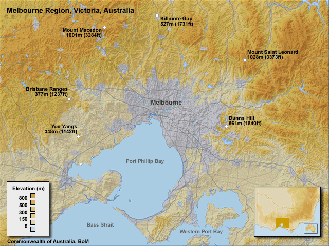
The highest elevation in the area surrounding Melbourne is to the east with Dunns Hill at 561m (1840ft), and further to the northeast Mount Saint Leonard at 1028m (3373ft). To the northwest of Melbourne is Mount Macedon, 1001m (3284ft ), and to the west there are several smaller ranges, the You Yangs, 348m (1142ft) and the Brisbane Ranges, at 377m (1237ft).
The location of the mountains of the Great Dividing Range can have a large influence on the local winds. In certain situations, they can act to block light southerly winds or they can be the source of night-time, northerly, katabatic, or drainage winds.
Port Phillip Bay and Bass Strait are other geographic features of importance, as they can provide a source of moisture with southerly winds. The sea surface temperature, which for this case is around 19°C in the Bay, can have an influence as well.
Local Airports of Concern
Let’s take a look at the location of the local airports, our primary areas of concern for the case.

Melbourne Airport is located 22 km (13.7 miles) to the northwest of the city of Melbourne. The airport is approximately 113 m (370 ft) above mean sea level.
The other local Melbourne airports discussed in this case, Avalon, Laverton and Moorabbin, are all close to mean sea level.
Climatology
Fog Frequency
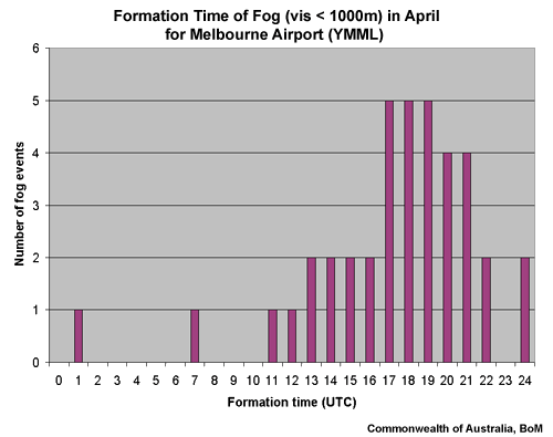
Fog Formation Times
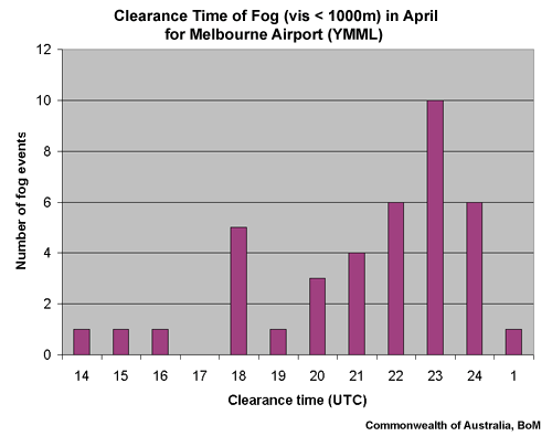
Fog Clearance Times
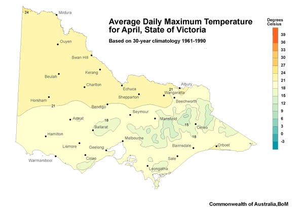
Average Daily High Temperature in April
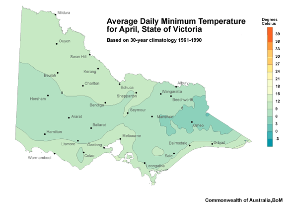
Average Daily Low Temperature in April
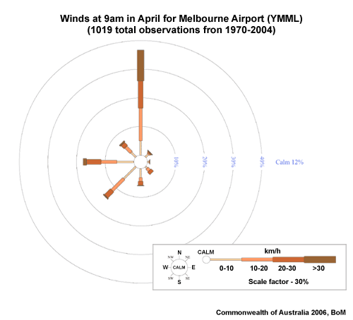
YMML 9AM April Windrose
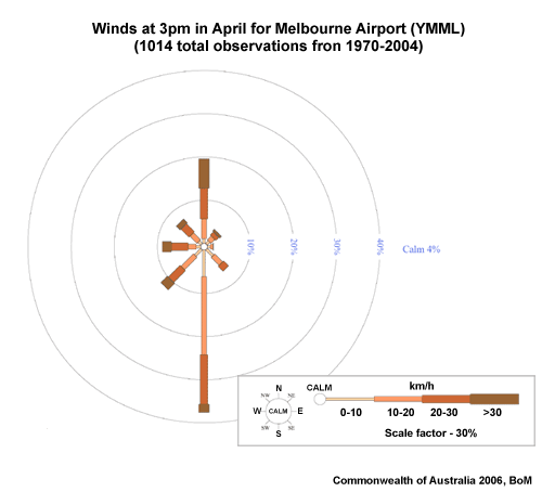
YMML 3AM April Windrose
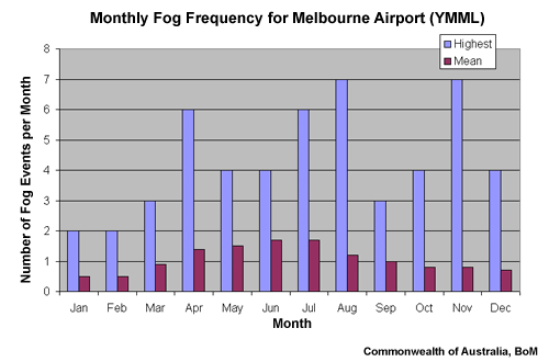
It’s always important to have the local climatology in mind.
In Melbourne, the most prevalent months for fog are the cooler months of April through August, although it can be seen from the graph shown, it is still possible to get fog in Melbourne at any time of the year. In April, the time of our case, Melbourne experiences, on average, at least one fog event.
Fog typically forms in the few hours prior to sunrise. This is when radiational cooling has had the maximum time to take effect, although anytime from late evening is common. Fog clearance times are typically mid-morning.
Average minimum and maximum temperatures for Melbourne in April are 9-12°C and 18-21°C respectively. And the most common wind direction in April for Melbourne Airport is a northerly wind at 9am and a southerly wind at 3pm.
Local Fog Aids
Local fog forecasting aids are used throughout Australia to help in the forecast decision process. These aids have been developed over the years by forecasters or researchers and their properties vary greatly. They range in the different aspects they try to predict, from forecasting onset time or the duration or likelihood of fog. They also differ in terms of the types of weather parameters taken into consideration, such as pressure, moisture, and synoptic type. And the calculation method varies from the use of statistical regression trends to a checklist approach.
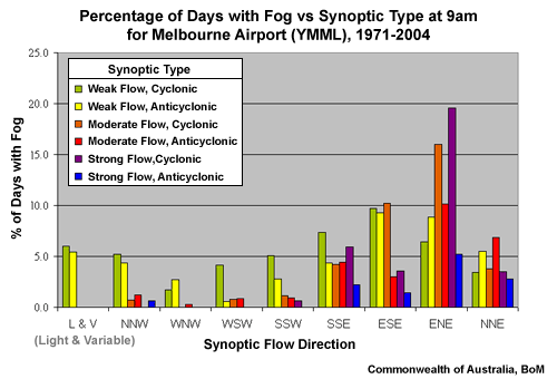
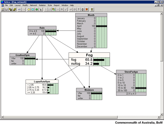
The Victorian Forecast Office, the site for our case, has developed and uses the Stern/Parkyn synoptic classification aid. The aid classifies the current forecast synoptic situation into one of 50 different synoptic types. To determine the synoptic type, the aid takes into consideration the gradient wind strength, wind direction and the cyclonicity of the synoptic situation, using pressure values from six locations in southeastern Australia. A climatology of the likelihood of fog for each synoptic type is displayed here. The Stern/Parkyn aid takes this a step further by including the 3pm temperature and dewpoint along with the current month to give a specific likelihood of fog percentage for the individual event.
Forecast Scenario
The current time for our case is 0300 UTC, which is 1pm local time, in Melbourne. Our task is to consider the possibility of fog in the Melbourne area tomorrow morning. We are responsible for four TAF’s:
- Melbourne Airport (YMML)
- Avalon Airport (YMAV)
- Laverton Airport (YLVT)
- and Moorabbin Airport (YMMB)
Our main concern is Melbourne Airport (YMML) as this is an international airport with several early morning flights expected daily.
NOTE: In April 2008, the time of this case study, 24-hour TAFs were issued for international airports in Australia. During November 2008, all Australian international airports, including YMML, changed to a 30-hour TAF.
The current 00 to 24 UTC Melbourne Airport TAF does not include fog, so we will need to decide if we are happy with this decision, or whether we should issue the TAF with the inclusion of fog. The 06-06 UTC TAF that we are working on is very important to the aviation industry as a lot of planning for the following day is based on it.
TAF YMML 052225Z 060024
17010KT CAVOK
FM15 VRB05KT 8000 HZ SCT008
FM23 04010KT CAVOK
RMK
T 16 20 21 15 Q 1028 1025 1024 1025
The model data we will use for this case study is the US GFS model. A comparison between the GFS model and the local MesoLaps model has already been conducted and there were no significant variations between them for the time period we are considering. So, for simplicity and time efficiency only the GFS model is presented in this case study. There will be two different runs of the GFS model available at different time periods of the case study, the 00 UTC and 06 UTC runs.
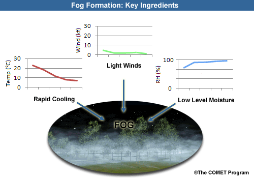
Our primary focus and forecast challenge will be forecasting fog potential. Throughout this case, we need to keep in mind the key ingredients required for fog formation. These are: sufficient low-level moisture, light winds and rapid cooling at the surface.
Current Forecast Situation
Let’s now take a look at the current synoptic set-up and forecast before moving on to the case challenge.
It is 0300 UTC, 1PM local time, on Sunday 6 April and the duty forecaster we are relieving gives us a quick briefing:
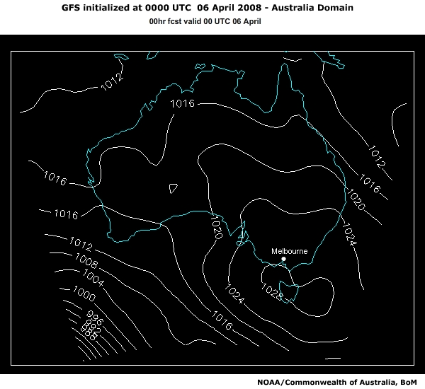
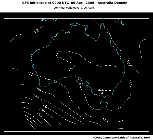
"Currently an upper ridge is dominating most of the continent and is associated with a surface high pressure system, located near Tasmania. This system is producing light winds over south-east Australia to at least 500hPa.
Mid and upper level clouds currently extend across much of South Australia. The mid and high level cloud over southern Australia (to our west) should continue to advect to the north of Victoria, due to the upper wind flow, but you may also want to monitor this.

In the past 24 hours, the high pressure system dominating our weather has gradually moved southeastwards across the state, and is currently located near Tasmania. Across the state temperatures have ranged from 16-21°C with onshore southerly winds and isolated showers in the south of the state.
Rainfall totals recorded since 9am local time yesterday morning were generally less than 2 millimetres and mostly fell yesterday afternoon. Daytime heating has already produced scattered convective clouds in the south and east of Victoria however the remaining isolated showers are expected to clear this afternoon as the high pressure system continues to strengthen in the Tasman Sea, and the atmosphere stabilises.
The forecast for Melbourne today is fine and mostly sunny, with cool to mild conditions and light to moderate southerly winds.
Overnight minimum temperatures are expected to be below average. Last night minimum temperatures in Melbourne were generally 2-4°C below average, ranging from 7-9°C.
As the high pressure system is expected to remain in the region for at least the next 24 hours, I expect your main concerns will be with the potential for fog or low cloud forming tonight or early tomorrow morning. We currently do not have fog on the Melbourne Airport TAF, but we do anticipate haze and scattered low cloud developing overnight. You may want to consider including fog.
TAF YMML 052225Z 060024
17010KT CAVOK
FM15 VRB05KT 8000 HZ SCT008
FM23 04010KT CAVOK
RMK
T 16 20 21 15 Q 1028 1025 1024 1025
I’ll leave you with the current forecasts. Catch you tomorrow morning. Have a good shift!"
Melbourne Forecast
Issued at 10:55 am EST on Sunday 6 April 2008
Warning Summary
Nil.
Forecast for Sunday
Fine. A mainly sunny day with light wind.
Precis:      Mainly sunny.
City:        Max 22
Laverton:    Max 22                 Yarra Glen:   Max 23
Tullamarine: Max 22                 Mt Dandenong: Max 17
Watsonia:    Max 22                 Scoresby:     Max 22
Frankston:   Max 20                 Geelong:      Max 21
Forecast for Monday
Fine apart from local morning fog. A mainly sunny day with light wind.
Precis:      Early fog then fine.
City:        Min 13   Max 23
Challenge: 0300 UTC
Overview
There are 3 parts to the case challenge; each representing a different time point in the case timeline. The timeline located on each page will update as time progresses.
- The time frame of the first section is set at 0300UTC, 1pm local time, on the afternoon
prior to the event. At this time, the forecaster typically begins considering and
formulating the 06-06 TAF for Melbourne Airport which is valid from 4pm to 4pm local time.
We will look at the model guidance and current observations in detail and make a decision on
the potential for fog.
- The second part of the case is set nine hours later, at 1200UTC, 10pm local time. At this
point in the event, the forecaster will be keeping a very close eye on all the incoming
observational data and model guidance. Here we will assess the current weather situation and
consider short term fog forecasting.
- The last section is set a further nine hours later at 2100UTC, 7am local time. Here we will address nowcasting fog potential and associated clearance times.
While moving through the case, you'll have access to the relevant data and observations by
clicking
this link: ![]() Doing so will open
a new browser window.
Doing so will open
a new browser window.
You can also access supporting topics. Topics relevant to the question at hand are marked.
|
Supporting Topics |
Data Products |
|---|---|
|
|
Ground Truthing the Synoptic Situation
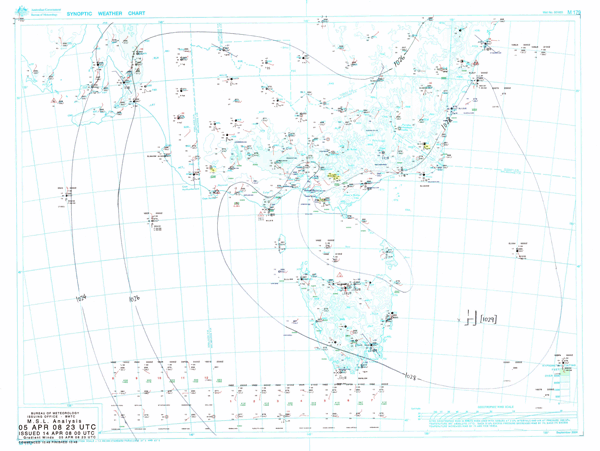
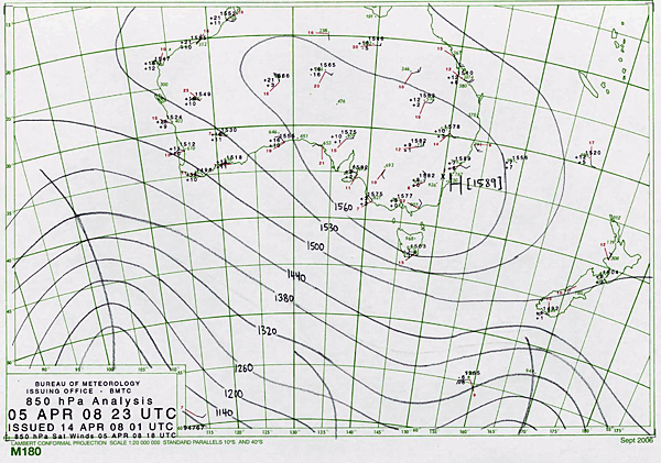
Let's start looking at some data. First let's consider the synoptic situation and the validity of the model forecasts.
NWP Analysis
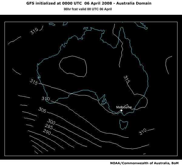
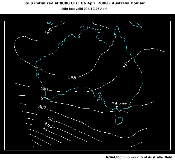
Hand Analysis
Click on the image below to open a larger .pdf version in a new window.
|
Supporting Topics |
Data Products |
|---|---|
|
|
Question
How are the MSLP and geopotential height fields verifying against the observational analyses? Are there any significant variations?
In addition to the data shown on the screen, use the Data Products link above to access to all of our current data products.
Select your response and record your comments or observations then click the Done button.
The correct answers are c) and d).
Ground truthing our model analysis against current observations should always be done. This is to ensure our forecast guidance has a good handle on the current situation. A comparison of the fields shows the model has no significant variations to the current synoptic situation. The surface high pressure system's location and strength are both well represented. In the upper levels, the associated high pressure ridge across the continent, along with the troughs, west and east of the continent are all handled well in regard to position and strength. At this stage the model seems to be capturing the situation well.
Initial Fog Assessment
Now that we have some confidence on the models performance, analyse the MSLP and geopotential height fields over the forecast period, 0000 to 2400 UTC on 06 April 2008. Respond to the following two questions.
|
Supporting Topics |
Data Products |
|---|---|
|
Fog Formation and Dissipation Processes: |
|
Question
Which synoptic feature provides the most favourable environment for fog development in the Melbourne region overnight?
The correct answer is a).
Question
Which of the following fog processes are typically produced in this synoptic situation?
The correct answers are a), b), e), f) and g).
A high pressure system is currently located over Tasmania and is forecast to be located to the east of Tasmania around 00UTC 7 April, 10am local time. High pressure systems at the surface provide a favourable environment for fog formation as they tend to promote the key low-level ingredients for fog formation: light winds, rapid cooling and high amounts of near-surface moisture.
The fog processes that are typically promoted in this synoptic situation are:
- Enhanced radiational cooling due to dry mid-upper levels allowing
maximum amounts of long wave radiation to escape the atmosphere.
- Light winds, which produce weak turbulent mixing, allowing low level moisture to be trapped; this effect is also enhanced through subsidence.
Stern/Parkyn Fog Aid (optional question)
Let's consider some of the output from the Stern/Parkyn fog aid. Entering the relevant pressure values for the six different locations the synoptic type is computed as type 32 - ENE Moderate Anticyclonic.
|
Supporting Topics |
Data Products |
|---|---|
Question
Using the figure correlating fog frequency with the particular synoptic type, what is the climatological probability of fog for this synoptic type? Is this synoptic type favourable for fog development? Record your response in the text field provided.
Add your comments or observations:
Using the 1971-2004 climatology, the current conditions indicate synoptic type 32.
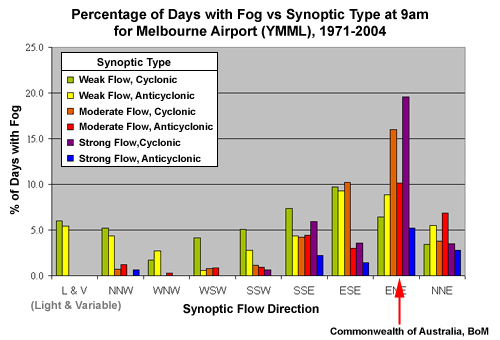
This is the 4th most favourable synoptic type for fog formation at Melbourne airport with around 10% of days of this synoptic type producing fog.
Mid- to Upper Level Moisture
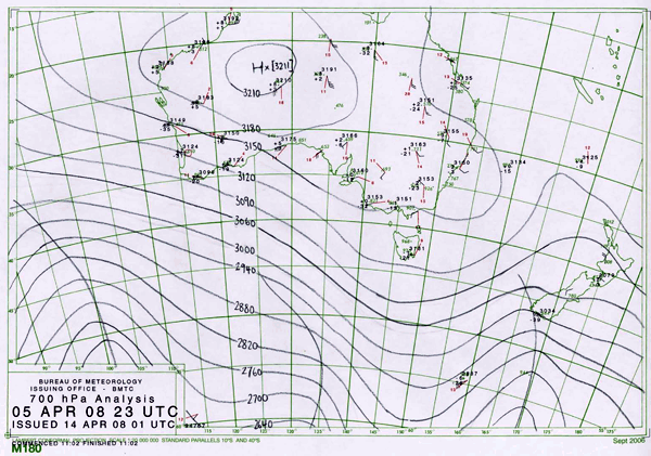
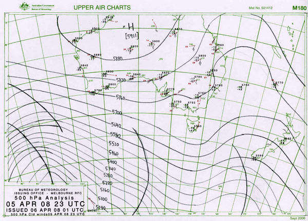
Let's take a look at the model analysis of relative humidity and wind fields at 500hPa and 700hPa and compare those against the latest satellite imagery and upper observations.
NWP Analysis
Satellite
Upper Analysis
Click on the image below to open a larger .pdf version in a new window.
|
Supporting Topics |
Data Products |
|---|---|
|
|
Question
Describe the relative humidity field associated with Victoria and its surrounds. Do the model analysis fields verify against the observations?
Record your comments:
Question
To answer the next question, first consider the current structure of the upper synoptic pattern and the potential evolution of the systems. The RH field indicates a region of cloud cover to the west of Victoria. Do you think this cloud will affect the Melbourne region and if so how do you think this would affect fog formation?
Your response:
Question
Now, let's investigate what the model predicts would happen with the cloud to the west of the state by looking at the evolution over the forecast period. Do you think the mid to upper levels are conducive to the formation of fog in the Melbourne region overnight?
The correct answer is Yes - The mid to upper levels are conducive to the formation of fog in the Melbourne region overnight.
The 500hPa fields show areas of high relative humidity to the west of Victoria. These areas coincide with strong equatorward flow on the western side of an upper trough located over the Coral Sea to the east of Australia. The upper pattern is highly meridional and would be expected to move very slowly during the forecast period. This verifies well with the satellite image loop showing high level cloud currently moving to the north of the state. If the airflow becomes more westerly with time during the forecast period, there is the potential that the high cloud could advect over the state. If the cloud advects over Victoria overnight and is thick enough, it could reduce radiational cooling and delay or even prevent fog forming. If the cloud came in after the fog had formed it could delay the dissipation of the fog.
The 700hPa fields also show areas of high relative humidity to the west of Victoria, but further west than the areas identified at the 500hPa level. This humidity is also coincident with south to southwesterly winds, so should not be a concern to us in Victoria overnight if the upper pattern persists. Otherwise low relative humidity is forecast across the entire state. This is good for fog formation, potentially allowing for maximum radiational cooling. Winds are generally light west to southwesterly throughout all levels over Victoria.
The model mid level forecasts are conducive to fog formation given that other key ingredients to be investigated are in place. Clear skies are expected over Melbourne initially tonight, as the mid-level southwesterly winds continue to advect the cloud north of the state. We should keep an eye on this overnight.
Low Level Moisture
With clear skies in the mid- to upper levels forecast, which is one ingredient favorable for fog formation, we should now consider the low level moisture.
NWP Analysis
Satellite
Hand Analysis
Click on the image below to open a larger .pdf version in a new window.
|
Supporting Topics |
Data Products |
|---|---|
|
|
Question
Starting with the 850hPa level, how does the model analysis verify against the satellite imagery and observations? What can you see and how could this affect fog formation?
Record your comments:
Question
Now let's look at the surface relative humidity. Are we looking for the same conditions at the surface as at the levels above the surface? Why or why not?
Your response:
Question
Look at the evolution of the low level humidity fields. Do you think the low levels are conducive to the formation of fog in the Melbourne region overnight?
The correct answer is Yes - The low levels are conducive to the formation of fog in the Melbourne region overnight.
The 850hPa relative humidity model analysis field indicates high moisture content in the northeast of the state. The satellite image confirms there is cloud in that area, although there is also evidence of some low cloud in the southern areas, which the model has not picked up on. The cloud could potentially prevent or delay the formation of fog overnight. It should be noted to keep an eye on this cloud as the forecast period progresses.
For fog formation, the ideal conditions are high relative humidity at the surface and low relative humidity above the surface. This allows for maximum radiational cooling at the surface down to the dewpoint temperature.
Looking at the evolution of the fields, at the 850hPa level, the moisture should contract to the east, while the surface moisture in our area of concern increases as the forecast period progresses. The light showers that occurred in the south of the state in the previous 24 hours would also contribute to moisten the surface. Both the 850hPa and surface conditions are conducive to fog formation overnight.
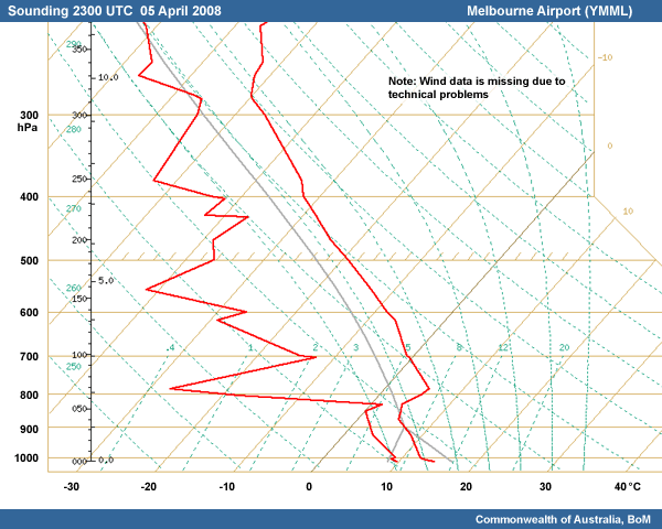
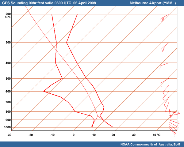
Soundings
Let's now look at the current sounding for Melbourne Airport for 23UTC, 9am local time, shown in red, overlayed with the sounding 24 hours prior, in blue. Typically the wind profile of the sounding would be located on the right hand side of the image, but due to instrument failure, we do not have any available observations for this time period.
YMML Sounding
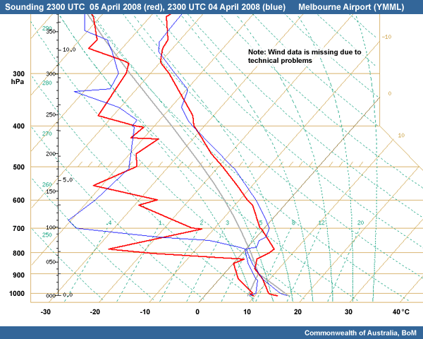
The blue trace shows a reasonable depth of moisture protruding into the freezing level, allowing for the production of showers.
Model Sounding
|
Supporting Topics |
Data Products |
|---|---|
Question
Observed Sounding
Consider the trends in the Melbourne Airport sounding in the last 24 hours. What features might you anticipate to be apparent in tomorrow mornings 9am LT 7 April Melbourne Airport sounding that would promote fog development?
The correct answers are a), b), c), e), g) and h).
Question
Observed vs Model Sounding
Compare the model analysis sounding for Melbourne Airport to the observed Melbourne Airport sounding valid 9am local time 6 April. Which features are captured well by the model sounding?
The correct answers are a), d), e) and g).
Question
Now let's take a look at the evolution of the model sounding. Do you think the sounding is conducive to fog formation in the Melbourne region in the overnight period?
The correct answer is Yes - the sounding is conducive to fog formation in the Melbourne region in the overnight period
The current trend in the changes in the observed sounding over the last 24 hours show subsidence, cooling near the surface, dry mid and upper levels, stabilising of the boundary layer and a high relative humidity content at the surface. These trends in the sounding would be expected to continue during the next 24 hours. The high pressure system dominating the weather should enhance subsidence and stabilisation of the boundary layer. The dry mid- and upper levels should still be present, allowing efficient radiational cooling of the low-level air, increasing the relative humidity near the surface.
Comparing the current Melbourne sounding with the model sounding shows a greater depth of low level moisture in the atmosphere than the model is predicting and therefore the model is predicting a lower and weaker inversion than is observed. Also, higher moisture content is observed at the surface than analysed in the model. Both of these factors could produce more convective cloud and potentially showers for the Melbourne region. These factors need to be monitored closely throughout the day. All the rest of the features were handled well.
Looking at the evolution of the model trace, it is clear the model is forecasting conditions at Melbourne Airport to become more stable as the subsidence inversion combines with radiational cooling to lower the inversion to the ground. A low inversion height promotes fog formation over low cloud formation, which requires more depth in moisture. Also the low inversion will inhibit the formation of a katabatic drainage flow from the high ground to the north and the associated advection of drier air over the airport. Winds are expected to become more easterly and ease overnight. The temperature and dewpoint temperature are not as close as we would like to see at this stage, but given that the model boundary layer is drier than observed, the forecast surface temperatures could potentially fall to the dewpoint. This vertical profile is therefore conducive to fog formation.
Forecast Temps and Dewpoints
A very important part of forecasting fog is accurately forecasting temperatures and dewpoint temperatures. This is typically not an easy task. There are a number of parameters to consider when forecasting the overnight temperature; is the wind going to ease: is the cloud going to clear, etc.
First of all we should consider the persistence forecasting method. If we start with last nights overnight minimum temperature, we can then determine how conditions will differ in the next 24 hours, and use this temperature as a starting point for tonight's minimum forecast. Last night in Melbourne, temperatures were generally 6-7°C, with the Melbourne city centre recording 9°C. Keep these temperatures in mind while we consider the model guidance output.
| Location | °C |
|---|---|
| MELB | 8.9 |
| YMML | 6.1 |
| YMMB | 6.8 |
| YLVT | 5.8 |
| YMAV | 7.3 |
| KMG | 7.5 |
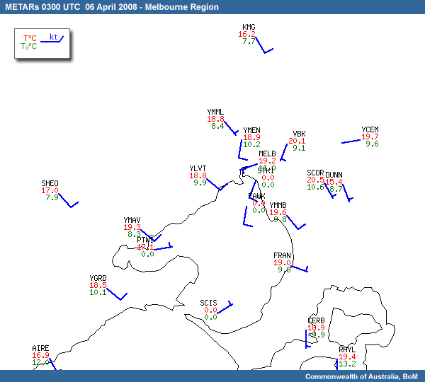
METARs Victoria and Melb
Model Data
|
Supporting Topics |
Data Products |
|---|---|
|
Case Reference Material: |
Question
Compare the 00 UTC model analysis temperature, dewpoint and wind fields against the surface observations at 00 UTC, 10am local time on 6 April. How does the model verify? Discuss the potential availability of moisture for the Melbourne region.
The correct answer is Yes - the temperature and dewpoint evolution is conducive to fog formation in the Melbourne region for the overnight period
The observed temperatures across the state at 00 UTC ranged from 15-18°C, although it was a little cooler in the ranges in the northeast of the state, at around 7-10°C.
The model forecast temperatures at 00 UTC are generally within a degree or two of the observed temperatures.
Observed dewpoint temperatures across the state range from 6-9°C inland, with higher values along the coast of around 10-12°C. At 00 UTC the model is forecasting the inland dewpoint temperatures a few degrees too high and the coastal dewpoint temperatures a few degrees too low. This should be noted.
At 00 UTC in the Melbourne region, the observed temperatures ranged from 12°C inland about the higher ground, to around 17°C along the coast. The model forecast temperatures of around 15-17°C, so besides the elevated locations, the model captured the surface temperatures reasonably well. Observed dewpoint temperatures range from around 8°C inland to 11°C about the coast. The model under forecast the coastal temperatures by a degree or two.
The surface winds in the Melbourne region are southerly and are expected to remain this way for the remainder of the afternoon. As dewpoint temperatures are higher about the coast, it is likely that moisture will be advected inland during the day.
The evolution of the temperatures and dewpoint temperatures from the model suggest temperatures should fall over night to around 9-10°C, with dewpoints holding around 8°C. Given that the model coastal dewpoints are 1-2°C too low it seems likely the air temperature and dewpoint should get close overnight. We should also keep in mind that last night minimum temperatures were a few degrees lower than the minimum the model forecast for tonight; there are no significant reasons why we shouldn't see temperatures that low again this evening. There is also the possibility of higher dewpoints than those forecast by the model. Overall this looks to be a conducive situation for fog formation overnight in the Melbourne region.
Fog Likelihood and Classification
Now that we have looked at some model guidance and current observations in detail, we need to consider including fog on the 0606 TAF for YMML.
|
Supporting Topics |
Data Products |
|---|---|
|
Case Reference Material:
Fog Theory: |
|
Question
Fog Likelihood and Classification
Taking into consideration your answers for the past 5 questions, what chance do you think fog has of forming at YMML overnight?
The correct answers are d) and e).
Question
If you are expecting fog, it is very important to understand what type of fog you are expecting, as all have slightly different key ingredients that you will need to focus on when forecasting. What type of fog classification would you expect and why?
The correct answers are a), d) and f).
At this stage, all the parameters we have taken into consideration have proven to be favourable for fog formation. Overnight we are expecting a small dewpoint depression at the surface, a low inversion height, light winds, rapid cooling with clear skies aloft. Given these factors, and for purposes of TAF reporting, experience has shown the chance of fog formation at the Melbourne airport is at least 30% to 49% chance.
The fog classification type expected is predominately a radiation fog event. Radiational cooling processes are expected to prevail overnight due to the availability of the key ingredients for radiation fog. It is possible that we may also get some upslope fog formation processes due to the interaction of the southerly airstream with the ranges to the north of Melbourne. It is also possible that once the fog has formed it could be advected elsewhere in the surrounding region. It is not typical to get a "pure" radiation fog, where only radiational processes are involved.
Onset and Duration
|
Supporting Topics |
Data Products |
|---|---|
|
Case Reference Material:
|
Question
Onset and Duration
Using all available model data, observations, official forecasts and climatology information for Melbourne, what time do you think the fog is likely to start affecting the airport?
The correct answers are c) OR d).
Question
Similarly, we also need to consider the clearance time of the fog. What time do you think fog is likely to clear from the airport?
The correct answers are d) OR e).
We need to consider when the temperature and dewpoint are likely to get close enough to form fog. A useful way to look at this is using the time series. This can quickly show when the relative humidity gets above 70% at the surface. The model suggests this will happen between 12-24 UTC, with higher humidity between 18-21 UTC.
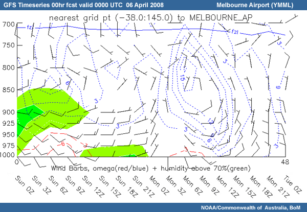
Now that we have some idea on the time frame, let's take a closer look at the details. The model sounding at 03UTC shows a surface temperature and dewpoint of 18°C and 7°C respectively.
Comparing these to the current observational temperature and dewpoint, we can see the model is currently under forecasting the dewpoint. We also should keep in mind that with the current southerly winds, which are predicted to continue throughout the afternoon, dewpoints temperatures of around 10°C could advect over the airport.
If we conservatively forecast the dewpoint temperature holding around 9°C, we could forecast the time the temperature drops to around 10°C. The model predicts the temperature to reach 10°C between 15-18 UTC. According to climatology, this is a favourable time for fog to develop, as the radiational cooling has had sufficient time to achieve a high relative humidity at the surface. Either the early morning (15-17 UTC) or just before dawn (18-20 UTC) would be reasonable forecast times.
Clearance time is typically considered to be a few hours after sunrise, especially in the early part of the fog season. At this time of year, the sun has enough energy to dissipate the fog relatively quickly. Of course, there are always reasons when this doesn't occur, such as with a particularly deep fog and when a cloud layer has developed above the fog.
The model suggests that there will be enough of a dewpoint depression by at least mid morning, around 24 UTC. Considering the situation is not much different from this morning, it could be useful to use persistence as a forecast method and see how long it took for the surface to heat up today. Looking at the METARS from this morning, we can see the temperature rose several degrees in the hour after sunrise and within two hours the temperature had risen 6°C.
                    METARAWS YMML 052030 34003/05KT 9999 1SC035 06.5/05.6 1027.2
                    METARAWS YMML 052100 35002/04KT 9999 1SC035 06.4/05.5 1027.5
                    METARAWS YMML 052130 34004/05KT 9999 1ST014 09.3/07.2 1027.8
                    METARAWS YMML 052200 33001/04KT 9999 1ST014 10.9/08.0 1027.9
                    METARAWS YMML 052230 28005/06KT 9999 1ST018 12.2/08.4 1028.0
                    METARAWS YMML 052300 23004/07KT 9999 1ST018 13.5/09.2 1028.1
                    METARAWS YMML 052330 17005/07KT 9999 1CU020 14.7/09.7 1028.2
                    METARAWS YMML 060000 16007/10KT 9999 1CU024 15.4/09.4 1028.1
Here's the actual TAF that was issued from the Victoria Office at this time.
        TAF YMML 060436Z  060606
        17010KT 9999 SCT030
        FM15 VRB05KT 8000 HZ SCT008
        FM00 04010KT CAVOK
        PROB30 1623 0500 FG
        RMK
        T 18 14 12 10 Q 1024 1025 1025 1026
Challenge: 1200 UTC
Monitoring Current Policy
The time has progressed nine hours to 1200UTC (10pm local time). A new model run is available to view, initialised at 06UTC 6 April. The guidance hasn’t had any significant changes since the last model run. You can now view this data through the data viewer.
![]() All data and observations used for the 1200 UTC
time point
All data and observations used for the 1200 UTC
time point
The 12-12UTC TAF has been issued in the past 9 hours, replacing the 06-06 TAF issued earlier. We can see that the forecast of fog has not changed.
        TAF YMML 061035Z 061212
        24005KT 9999 SCT030
        FM15 VRB05KT 8000 HZ SCT008
        FM00 04010KT CAVOK
        FM05 15008KT 9999 SCT045
        PROB30 1623 0500 FG
        RMK
        T 11 10 08 09 Q 1027 1027 1026 1027
With that in mind, we are now at the point of the evening shift where it is crucial to have a good handle on the current weather situation. We need to keep a close eye on our forecast policy and the progression of the preconditions for fog formation.
Let’s see how our afternoon forecast policy is going. As a reminder, it included:
- Clear skies aloft, the high level cloud was expected to advect north of the state.
- Available surface moisture
- Stabilising atmosphere, with radiational cooling at the surface
- Temperatures and dewpoints to be approaching saturation.
|
Supporting Topics |
Data Products |
|---|---|
|
Fog Formation and Dissipation Processes: Preconditions |
Question
Using the latest IR satellite imagery, Melbourne Airport sounding and surface observations, which of the policy elements for the Melbourne area are on track?
All are correct.
The latest IR satellite imagery generally shows clear skies aloft. The mid- to high level cloud to the west of the state, did advect north of the state as we expected, although some high cloud from south of the continent has advected towards Melbourne. This cloud is very patchy and is not expected to affect fog formation.
Melbourne Airport’s 11 UTC sounding compared to last night’s 11 UTC sounding shows a continuation of clear skies aloft, some low level stabilising, establishment of a lower inversion, some radiational cooling and moistening of the lower layers, including the surface, leading to the temperature and dewpoint approaching saturation.
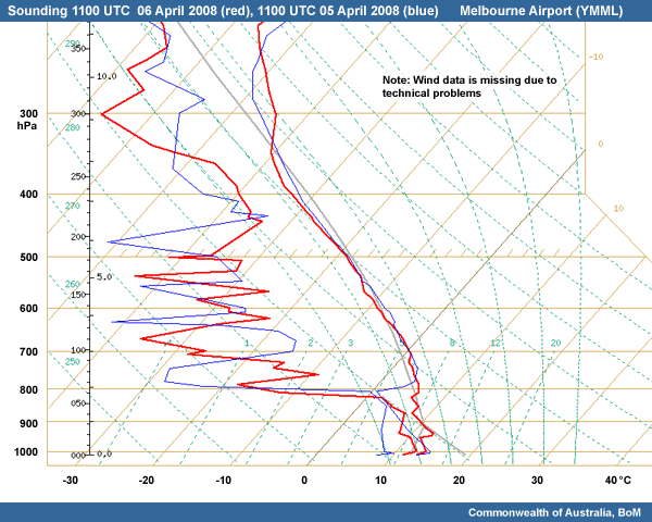
At this stage, our forecast policy is on track. There is the possibility that fog may develop sooner rather than later, as dewpoint temperatures are a little higher than forecast, around 10-11°C across Melbourne.
Fog Analysis 1200 UTC
The forecast time for fog formation is now only 4 hours away. Keeping in mind the possibility of fog forming earlier than forecast, we should check to see if any has formed in the area already.
|
Supporting Topics |
Data Products |
|---|---|
|
Case Reference Material: |
Question
Analyse all the current available observations to determine areas of fog and low cloud. Is there any evidence of fog and/or low cloud already in the Melbourne area or surrounds?
The correct answer is Yes, there is fog and low cloud in the area.
Question
Discuss the characteristics, such as cloud base heights and visibility, associated with the areas of fog or low cloud.
The correct answers are a), b) and c).
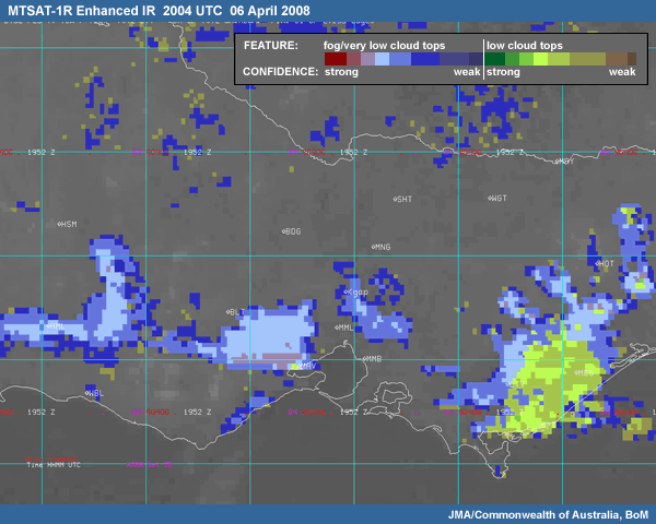
It is clear straight away on the enhanced infrared satellite image that fog/low cloud has already developed in the northwest quadrant of the Melbourne area. There is a patch of light to dark blue, which in this enhancement, is usually representative of fog or low cloud.
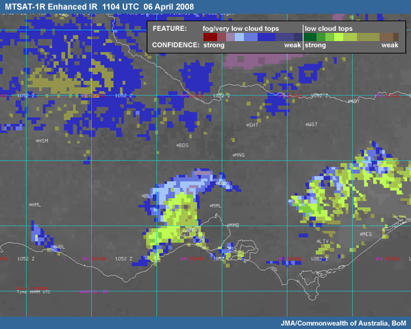
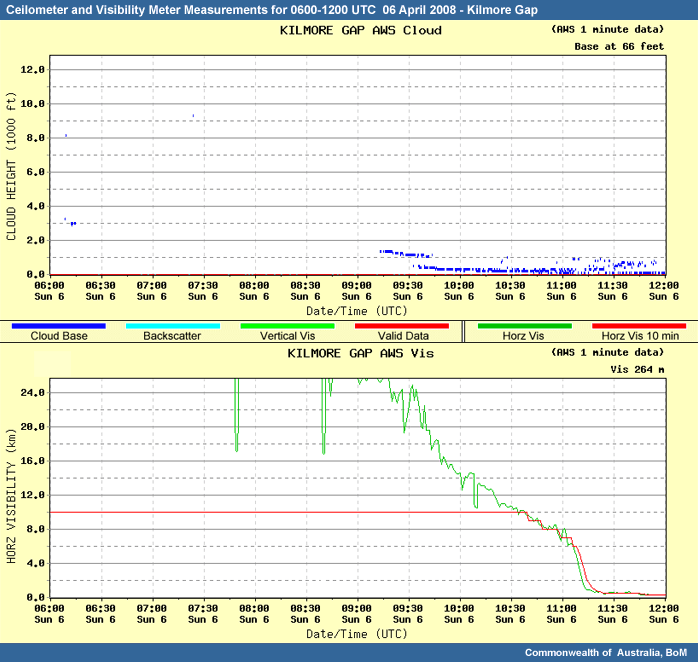
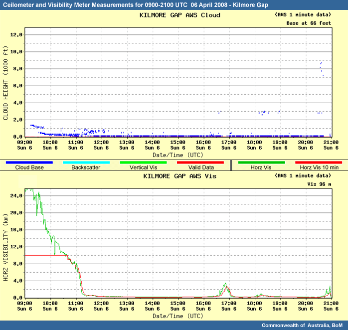
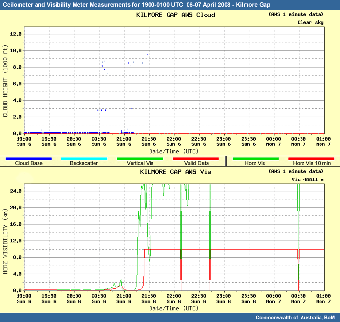
Kilmore Gap to the north of Melbourne is located within the fog area detected. Reports from the ceilometer at Kilmore Gap are currently showing a base of around 50 metres with a horizontal visibility of around 250 metres. This immediately suggests fog, but we also need to keep in mind that Kilmore Gap is an elevated site. The instrumentation is located about 1700 feet above sea level. Therefore fog at Kilmore Gap could still be low cloud in Melbourne. We will need to get confirmation of fog from another observation site or tool.
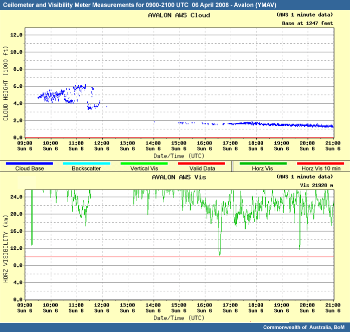
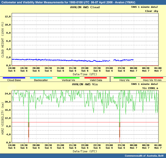
There is also a green area on the imagery, which can indicate low cloud over Avalon Airport and further west of Melbourne. The ceilometer at Avalon Airport suggests the cloud base is around 4000 feet.
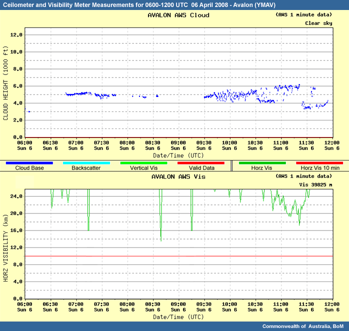
Neither Kilmore Gap or Avalon Airport have an observer onsite, therefore no ground weather observation can be used to back up this information. An inspection of the temperature and dewpoint, show a small dewpoint depression of about 0.5°C (T=10.8°C and Td=10.3°C), at Kilmore Gap and a larger depression at Avalon of 3.6°C (T=14.6°C and Td=11.0°C). This helps confirm that the cloud base is likely to be higher at Avalon than Kilmore Gap.
As you can see from our discussion on observations, it is always best to use observations in conjunction with each other, rather than in isolation. The ceilometer and visibility meters were used in conjunction with the satellite imagery, for confirmation of fog and low cloud. As this instrumentation is not abundant, a simple check of the temperature and dewpoint can help confirm or deny a report of fog/low cloud.
Observational Analysis
Now that we have identified fog areas, we need to start considering the current environment and whether fog is likely to form elsewhere in the Melbourne area overnight. Carefully analyse the current 12UTC surface observations in conjunction with the model guidance. Consider which areas you are most concerned with.
|
Supporting Topics |
Data Products |
|---|---|
|
Case Reference Material:
|
Question
Analyse all the current available observations to determine areas of fog and low cloud. Is there any evidence of fog and/or low cloud already in the Melbourne area or surrounds?
Question
Short term forecast
Considering the location of the fog bank in the current 1204 UTC satellite image, combined with the local observations analysed in the previous question and the model forecasts, would you change the current YMML TAF?
        TAF YMML 061035Z 061212
        24005KT 9999 SCT030
        FM15 VRB05KT 8000 HZ SCT008
        FM00 04010KT CAVOK
        FM05 15008KT 9999 SCT045
        PROB30 1623 0500 FG
        RMK
        T 11 10 08 09 Q 1027 1027 1026 1027
The correct answer is Yes
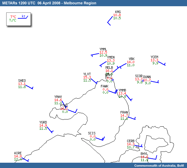
The locations around the bay seem to be holding temperatures a little higher, at around 14-15°C, than further inland, which are around 11-13°C. This is possibly due to the influence of warm bay temperatures, which are approximately 19°C, advecting over the coastal locations. Melbourne Airport has the smallest difference between the temperature and dewpoint temperature out of the local aerodromes with 12.5°C and 10.9°C respectively.
At this stage, radiation fog is still a possibility at Melbourne, Laverton and Moorabbin airports. Due to the low cloud at Avalon, it seems unlikely at this stage that fog will form there.
Concerns of the fog bank in the north advecting south towards the Melbourne airports is not expected at the moment as generally the winds tend to have a southerly component to them. Although, if we look closely at the recent Melbourne Airport and Essendon Airport (YMEN) wind observations, there is more of a westerly component to the wind.
Looking at the model winds, we can see that the general flow is forecast to ease and shift easterly overnight, before tending northeasterly around sunrise. If the model forecasts this correctly and the fog bank stays to the north and west of Melbourne, advected fog should not be a problem to any of the Melbourne TAFs.
This does presume the model has a good handle on the low level winds, we have already noticed the winds becoming more westerly around Melbourne Airport. If the winds continue to shift westerly or even northwesterly, advected fog could be a concern to the Melbourne TAFs.
Another fact that we should be wary of, is that fog could still form to the northeast of Melbourne, again providing issues with advected fog, particularly at Melbourne Airport and Moorabbin.
At this stage, I would suggest there is no reason to change the current 12-12 Melbourne Airport TAF.
        TAF YMML 061035Z 061212
        24005KT 9999 SCT030
        FM15 VRB05KT 8000 HZ SCT008
        FM00 04010KT CAVOK
        FM05 15008KT 9999 SCT045
        PROB30 1623 0500 FG
        RMK
        T 11 10 08 09 Q 1027 1027 1026 1027
The temperature and dewpoint temperature are closing, but do not suggest an imminent concern of fog development. Also, advected fog is not a concern as the potential fog bank is to the north and the airport is currently experiencing light west to southwesterly winds.
The forecaster on shift during the actual event did not amend any forecasts at this stage.
Challenge: 2100 UTC
Fog Analysis 2100 UTC
We’ve again jumped ahead in time. It’s now 21 UTC, 7am local time. Five hours have elapsed since fog was forecast to commence at Melbourne Airport based on the 12-12 TAF. Let’s investigate what has happened in the last 9 hours. Has fog formed at Melbourne Airport as forecast? Has more fog developed elsewhere?
|
Supporting Topics |
Data Products |
|---|---|
|
Case Reference Material: |
|
Question
Using all available current observations, which areas are currently affected by fog?
The correct answers are b), d), f) and g).
The enhanced satellite imagery shows a patch of fog or low cloud over Avalon and to the west. There is also an area of fog or low cloud near and to the east of Kilmore Gap.
The ceilometer suggests the area over Avalon is low cloud with a cloud base of around 1200 feet.
The cloud is still on the ground at Kilmore Gap.
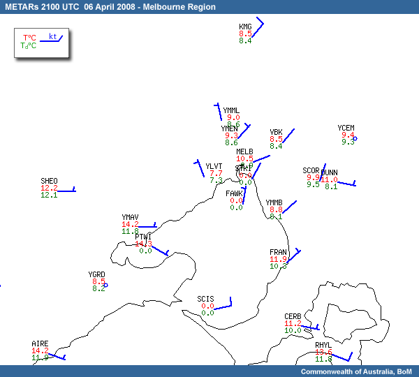
Taking the surface temperature and dewpoint observations into consideration, the patch of fog or low cloud east of Kilmore Gap is likely to be fog. Both Viewbank and Scoresby in the eastern suburbs of Melbourne are reporting a temperature and dewpoint depression of less than 0.5°C.
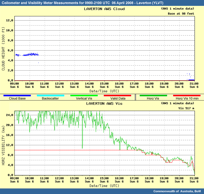
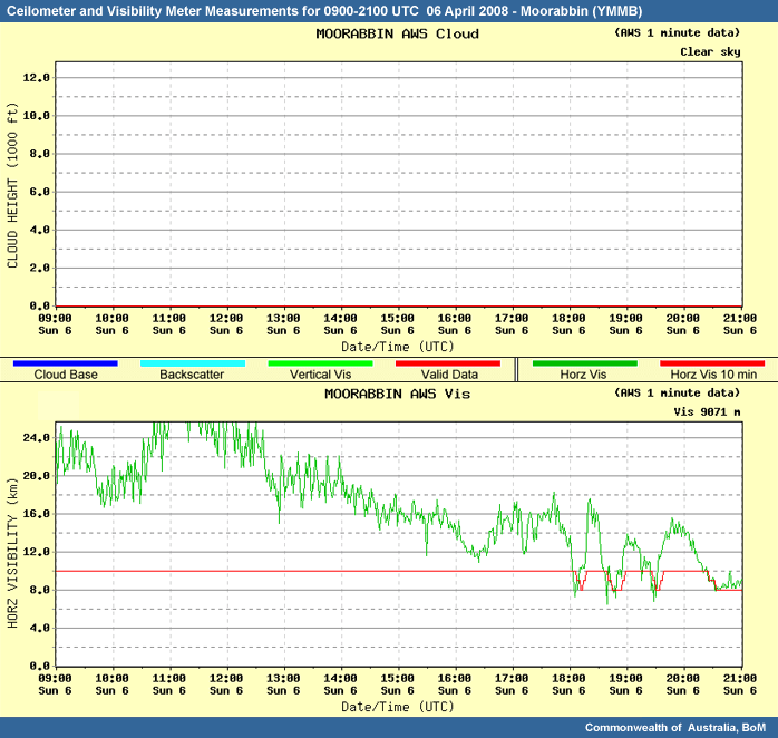
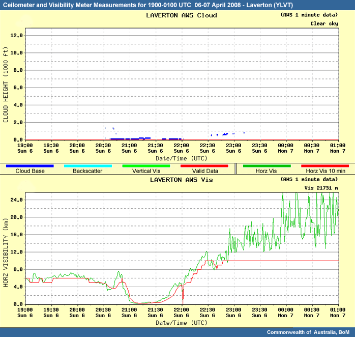
After checking out the other ceilometers at our local airports, we find Laverton is also being affected by fog, with the visibility dropping to 500 m just in the last few minutes.
The visibility at Moorabbin has reduced to around 9000 m.
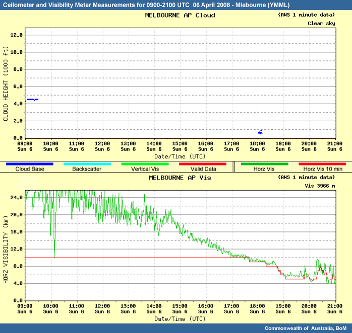
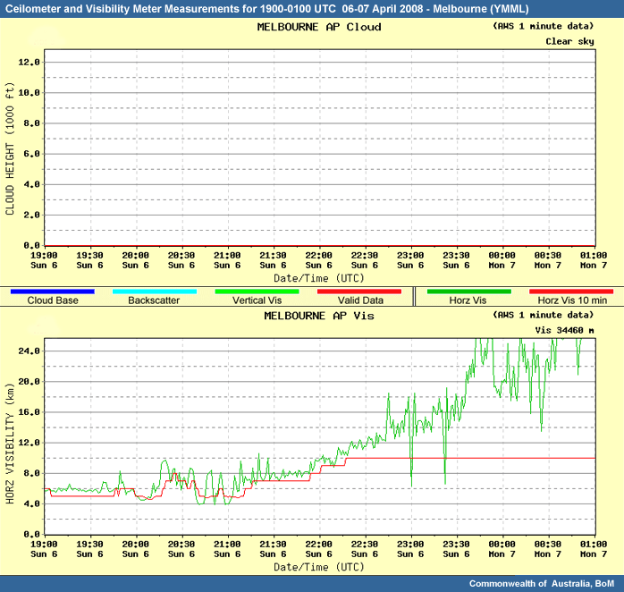
Melbourne Airport has an observer onsite and is currently reporting 5000 m in mist with one eighth of sky covered in stratus at 200 ft.
Looking at the temperatures and dewpoints of the local airports, we can confirm that most observing sites in Melbourne have less than one degree dewpoint depression, except Avalon, where the separation is still a couple of degrees.
The areas currently affected by fog are Kilmore Gap, the northeast suburbs, Laverton and the western suburbs of Melbourne.
Observational Analysis 2100 UTC
Now that we have identified the current fog areas, we again need to consider the surrounding areas for the potential of fog for the next few hours. Keep in mind the current time and climatology. Also note sunrise time for the 7th of April is 6:40am.
|
Supporting Topics |
Data Products |
|---|---|
|
Case Reference Material:
|
|
Question
Are you concerned with radiation or advected fog at any of our local Melbourne TAFs for the next few hours?
We already have fog reported at Laverton. Due to the light northwest winds, fog is expected is affect the airport potentially for the next few hours. Fog is not expected at Avalon, due to the low cloud currently over the airport.
In the northeast suburbs winds have now shifted light northeasterly, so we should be quite concerned with the potential of advecting fog currently located northeast of Melbourne, to the Moorabbin Airport, especially considering Moorabbin already has visibility reductions down to 9000 m.
Melbourne Airport is the other airport of concern. Melbourne Airport (YMML) is reporting light northerly winds and mist down to 5000 metres, but there doesn’t seem to be any decent bank of fog directly to the north of the airport. Radiation fog could still form here, although the sunrise did occur around 20 minutes ago, so temperatures should start to rise very soon.
Fog Nowcasting
Now, let’s focus on Moorabbin. We know we have a fog bank to the north of the airport. Consider the potential of advected fog, using all available observations and model guidance.
|
Supporting Topics |
Data Products |
|---|---|
|
Case Reference Material:
|
|
Question
Taking into consideration the latest Moorabbin METAR, which TTF option would you consider to be the best forecast for this scenario? Note: a Trend Type Forecast, is a 3-hour forecast which overrides the TAF.
Either a) or d) are appropriate
Looking at a loop of the enhanced IR satellite imagery, we can see the fog bank in the northeast suburbs gradually advecting southwards. Determining the arrival of the fog, purely through advection processes, it looks as though the fog is likely to be in the area of Moorabbin in around an hour or so. Of course, the fog area could expand as it advects, the wind could increase and advect it quicker or the effect of sunrise and some mixing could always alter the arrival time. This narrows the TTF options down to the 3 forecasts that mention fog, options 1, 3, and 4.
Next we need to consider the clearance of the fog. We need to consider several things. As the fog is advected, how long will the advecting conditions prevail? At this stage, according to the model guidance, it looks like the northerly winds will prevail for at least the next few hours. How large is the bank of fog? The fog bank doesn’t seem large, so dissipation due to solar radiation should have a big impact.
We could also take into consideration the depth of the fog. Deep fogs typically take longer to dissipate than shallow fogs. As we are considering the depth of the fog in the eastern suburbs, let’s compare the surface observations at Scoresby, which is likely to be in fog, to observations at Dunns Hill, which is located nearby and is about 561 m above sea level (1840ft). At 21UTC the air and dewpoint temperature at Scoresby are close with 9.9°C and 9.5°C respectively. At Dunns Hill the air and dewpoint temperatures are 11°C and 8.1°C, therefore a 3°C separation. This suggests that in the northeastern suburbs the fog layer is less than 500m deep, which indicates the fog isn’t very thick and allows for radiative and mixing processes to clear the fog quickly.
Climatology for fog clearance at this time of year is usually beween 22-24UTC.
Using persistence forecasting we could also consider the previous day temperatures. They actually rose 6°C between 21-2230 UTC, 7-8:30am local time. There is the potential that heating will be a little slower today since fog is present, but you can expect fog to be dissipating by at least 23UTC. This then cancels out the scenario where fog persists until 24UTC, making either option 1. or 4. a reasonable forecast.
METAR for YMMB 2100-2100 UTC 05-06 April 2008
METARAWS YMMB 2100 00000/00KT //// 07.4/06.5 1027.4
METARAWS YMMB 2130 00000/00KT //// 08.7/07.8 1027.6
METARAWS YMMB 2200 00000/00KT //// 11.1/09.6 1027.9
METARAWS YMMB 2230 00000/00KT //// 12.5/09.7 1028.0
METARAWS YMMB 2300 13004/05KT //// 14.4/09.4 1027.9
METARAWS YMMB 2330 14005/07KT //// 15.3/09.9 1028.0
METARAWS YMMB 0000 15007/11KT //// 16.3/10.4 1027.9
METARAWS YMMB 0030 11010/13KT //// 17.3/10.0 1027.7
METARAWS YMMB 0100 15011/17KT //// 17.8/10.0 1027.5
METARAWS YMMB 0130 13009/16KT //// 18.6/10.2 1027.2
METARAWS YMMB 0200 11010/16KT //// 18.8/09.9 1026.9
METARAWS YMMB 0230 13008/12KT //// 18.3/09.9 1026.3
METARAWS YMMB 0300 14010/14KT //// 19.6/09.8 1025.9
METARAWS YMMB 0330 14011/14KT //// 19.2/10.0 1025.4
METARAWS YMMB 0400 15011/15KT //// 19.2/09.7 1025.1
METARAWS YMMB 0430 14011/15KT //// 19.9/10.1 1024.9
METARAWS YMMB 0500 15011/15KT //// 19.7/10.4 1024.8
METARAWS YMMB 0530 15010/17KT //// 20.0/10.7 1024.6
METARAWS YMMB 0600 15013/17KT //// 19.4/11.0 1024.8
METARAWS YMMB 0630 16013/18KT //// 18.9/11.3 1025.0
METARAWS YMMB 0700 17011/17KT //// 18.2/11.8 1025.0
METARAWS YMMB 0730 17011/15KT //// 17.5/11.8 1025.2
METARAWS YMMB 0800 17012/17KT //// 16.8/11.7 1025.4
METARAWS YMMB 0830 17009/11KT //// 16.1/11.7 1025.4
METARAWS YMMB 0900 16009/12KT //// 15.8/11.8 1025.5
METARAWS YMMB 0930 15009/11KT //// 15.6/11.8 1025.7
METARAWS YMMB 1000 14010/13KT //// 15.3/11.5 1025.7
METARAWS YMMB 1030 14010/12KT //// 14.7/11.3 1025.7
METARAWS YMMB 1100 14009/11KT //// 14.2/11.2 1025.8
METARAWS YMMB 1130 13007/09KT //// 13.7/10.9 1026.0
METARAWS YMMB 1200 14008/11KT //// 13.4/10.8 1026.1
METARAWS YMMB 1230 14008/10KT //// 13.2/10.6 1026.0
METARAWS YMMB 1300 13007/10KT //// 13.0/10.7 1026.0
METARAWS YMMB 1330 12007/09KT //// 12.8/10.6 1025.9
METARAWS YMMB 1400 12007/08KT //// 12.5/10.6 1025.7
METARAWS YMMB 1430 12006/07KT //// 11.7/10.0 1025.8
METARAWS YMMB 1500 14005/06KT //// 11.5/10.1 1025.9
METARAWS YMMB 1530 14006/07KT //// 11.2/10.0 1025.9
METARAWS YMMB 1600 12006/07KT //// 11.0/09.8 1025.7
METARAWS YMMB 1630 10004/04KT //// 11.0/09.8 1025.6
METARAWS YMMB 1700 07003/04KT //// 10.6/09.4 1025.6
METARAWS YMMB 1730 08004/04KT //// 09.8/08.8 1025.6
METARAWS YMMB 1800 08004/04KT //// 10.2/09.3 1025.6
METARAWS YMMB 1830 08004/05KT //// 08.9/07.9 1025.4
METARAWS YMMB 1900 07004/05KT //// 09.8/09.1 1025.6
METARAWS YMMB 1930 07002/03KT //// 09.4/08.5 1025.7
METARAWS YMMB 2000 06003/03KT //// 09.5/08.8 1025.7
METARAWS YMMB 2030 05002/03KT //// 08.8/08.1 1025.8
METARAWS YMMB 2100 05003/04KT //// 08.8/08.1 1025.9
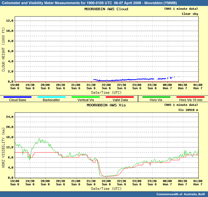
And in the actual case, the fog did clear from Moorabbin by around 2220 UTC, 8:20 local time.
Summary
Overview
Let’s briefly review the case and highlight some of the key components of the fog forecasting process.
Overnight on Sunday the 6th of April 2008, fog and low cloud formed in the Melbourne region. During the evening, the key ingredients for fog - clear skies, light winds and available moisture at the surface – along with weak upslope flow, produced fog and low cloud on the southern slopes of the ranges to the north and west of Melbourne.
This area of fog and low cloud expanded overnight into the northeastern suburbs of Melbourne. Winds shifted from light southerlies in the evening to light northerlies by sunrise. This change in wind direction allowed the fog in the north of Melbourne to advect southwards over Laverton and Moorabbin airports. The fog gradually dissipated while continuing to advect southwards over Port Phillip Bay. The fog eventually cleared by late morning.
Melbourne Airport managed to avoid being affected by fog, although mist was reported at the airport reducing visibility to 5000 m for a couple of hours. Avalon Airport was not affected by fog, due to a layer of cloud, which lowered to around 1000 ft around sunrise.
Precursors
Understanding and recognising precursors for fog formation is very important in accurately predicting fog events. Being aware of a potential fog situation will help prevent unforecast fog events, which can cause severe impacts on aviation industry operations. The earlier the precursors can be accurately recognised provides the end users with more planning and preparation time.
Conditions were favourable for fog development overnight, due to the synoptic situation affecting the region. The high pressure system provided all the key ingredients. Light winds, rapid cooling due to clear skies aloft and sufficient low level moisture, enhanced by onshore southerly airflow and isolated showers during the preceding day. Fog potential was evident the afternoon prior to the event through both the model guidance and through short term forecasting based on an analysis of the afternoon observations.
Development
Having a clear understanding of the various processes that can lead to fog formation is important in recognising the type of fog that will form, where fog might form and how it will interact with the local topography.
This case provides a good example whereby a combination of radiative processes enhanced by upslope processes act to produce fog and low cloud. The moist, onshore flow interacted with the hills to the north of Melbourne, resulting in upslope flow and associated cooling enhanced the formation of fog on the slopes.
The model guidance predicted the southerly winds would shift northerly overnight. Advected fog could then be an issue to southern areas if fog formed in the north. Having knowledge of local topography and flow regimes is therefore critical to forecasting fog.
Satellite Identification
Satellite imagery is especially useful in fog monitoring. As the temperature of fog is often close to the ground temperature, standard infrared channels are not useful in identifying fog. Enhanced infrared imagery is used instead and is often one of the first observational tools to show the presence of fog.
Satellite imagery can also show areas of fog expanding and advecting, which happened in this case in the northeastern suburbs. It can also be used to monitor for fog’s eventual dissipation.
Whenever possible, look for surface observations to verify the presence of fog. In this case, evidence of fog or low cloud appeared in the enhanced IR earlier than forecast and was verified by surface observations.
Surface Observations
As fog is a surface based phenomena, surface observations are relied on heavily in both forecasting and identifying fog. Trends in surface observations are essential in short term forecasting and nowcasting of fog. Recognising trends in observations early, helps to provide longer lead times for formation. Surface observations are also crucial in identifying and verifying fog.
Fog was confirmed through several different surface observational tools throughout the case. Ceilometers and visibility meters provided a useful, although limited, insight into the occurrence of fog at a particular location. The five locations around Melbourne were all used extensively throughout this event.
Surface air temperature and dewpoint temperatures can also be used to confirm saturation at the surface, especially for areas without more advanced instrumentation. Saturation at Kilmore Gap, Laverton and Moorabbin confirmed the observed fog on the ceilometer/visibility meters. Avalon reported a dewpoint depression of a couple of degrees all night, which verifies the report of low cloud instead of fog.
Analysing the wind observations was also particularly useful in this case, due to the eventual advection of fog.
Model Performance
The model performed reasonably well in this fog event. The model forecast the key ingredients for fog formation to coincide in the Melbourne region overnight. The forecast of surface winds to shift from southerlies during the evening to northerlies by sunrise was well captured, potentially alerting a forecaster well in advance that should fog form on the southern slopes of the ranges to the north of Melbourne, advected fog would be a possibility.
One area of weakness in the model for this case was under-forecasting the dewpoint temperatures in the Melbourne region. As a consequence of the under-forecasting of the dewpoint, the model would lead you to think that saturation and fog would form later. But an astute forecaster should have noticed this while ground truthing the model during the afternoon prior to the event.
Ground truthing the model performance should always be done before implicitly believing the model output.
The local Bayesian network fog decision aid was run on the actual day of the event; it also suggested a favourable situation for the formation of fog. The extended Stern/Parkyn aid, which includes the additional information of temperature, dewpoint and time of year, forecast the probability of fog to be at 20.5% chance. The synoptic flow was deemed very favourable. The moisture content was deemed at least favourable, with a "worst case scenario" output producing a very favourable situation. Therefore overall, the Bayesian network forecast the likelihood of fog at Melbourne Airport to be at least a 33% chance and the worst case scenario, with very favourable moisture, gave a 66% chance of fog forming.

The national Regano fog aid, had interesting results with only a 5% likelihood of fog when run with the 02UTC observations. This chance gradually increased throughout the afternoon and evening, to reach 31% chance at 14UTC. This demonstrates that forecasting a fog event is more achievable closer to the onset of the event. For more information on the Regano fog aid, see the supporting topics.
Nowcasting and Dissipation
Nowcasting fog is difficult. Fog can form or dissipate based on a slight change in conditions. Having a good understanding of the environment the fog is located in is crucial in nowcasting. Knowing the depth, intensity and areal extent of the fog will help with forecasting the duration of the fog event.
The depth of fog was not thick in this event, so along with the increase in solar radiation after sunrise, the fog dissipated relatively quickly. The fog cleared Kilmore Gap with the advection of drier northerly winds around 7:15am. Laverton and Moorabbin both reported fog for around 45 minutes, before improving to mist conditions until mid morning. The mist conditions at Melbourne Airport gradually improved around 8am and the low cloud cleared Avalon by 9am.
Summary
In closing, this case presented the forecasters in Victoria with the challenges of:
- recognising the synoptic setting that may lead to local onset of fog,
- forecasting the possibility of key fog ingredients,
- monitoring the onset of fog,
- nowcasting fog and low cloud,
- and forecasting clearance times.
This process involves:
- integrating a conceptual understanding of fog formation,
- knowledge of local climatology,
- integration of NWP and observed data,
- and use of observational tools for monitoring.
The accompanying Fog Forecasting and Nowcasting Process Checklist (download as .pdf) summarises the key points of the process and can be printed for future use.
FOG FORECASTING AND NOWCASTING PROCESS CHECKLIST
ANALYSING PRECURSORS AND FORECASTING
- Analyse latest observations:
- Satellite images
- MSLP and upper analyses
- Surface observations
- Temperature soundings
- Ground truth NWP guidance
- Analyse trends in NWP guidance, in particular:
- MSLP & upper system structure
- Relative humidity in mid-upper levels (700, 500hPa)
- Relative humidity in low levels (850hPa and near sfc)
- Winds through all levels, especially the low levels.
- Temperature and dewpoint at the surface
- Soundings
- Determine which of the requirements are likely to be sufficient for fog formation?
- Rapid cooling
- Light winds
- Low level moisture
- Determine the fog type:
- Radiation fog
- Advection fog
- Post rain fog
- Upslope fog
- Steam fog
- Advected fog
- Sea fog
- Not expecting fog
- Use local aids, consider local influences, climatology and persistence forecasting to help determine likelihood of fog.
DEVELOPMENT/MONITORING
- Identify fog areas by monitoring:
- Enhanced satellite imagery
- Surface observations (especially t, td, winds)
- Ceilometer/visibility meter data
- Temperature soundings
- Profiler data (if available)
NOWCASTING AND DISSIPATION
- Analyse the depth, intensity and aerial extent of the fog based on:
- Observations
- Satellite imagery
- Ceilometer/Visibility meter
- Surface observations (t, td, winds)
- Soundings
- NWP guidance
- Climatology
- Observations
- Identify dissipation processes by considering the:
- Changes in wind direction and strength
- Potential advection of different airmasses
- Increase in solar radiation
- Influence of cloud layers
Contributors
This module was developed with funding from the Commonwealth of Australia, Bureau of Meteorology in collaboration with the UCAR COMET Program.
Satellite imagery courtesy of the Japan Meteorological Agency (https://www.jma.go.jp/jma/indexe.html) and processed by the Bureau of Meteorology.
Various graphics and data products courtesy of the Commonwealth of Australia, Bureau of Meteorology (www.bom.gov.au)
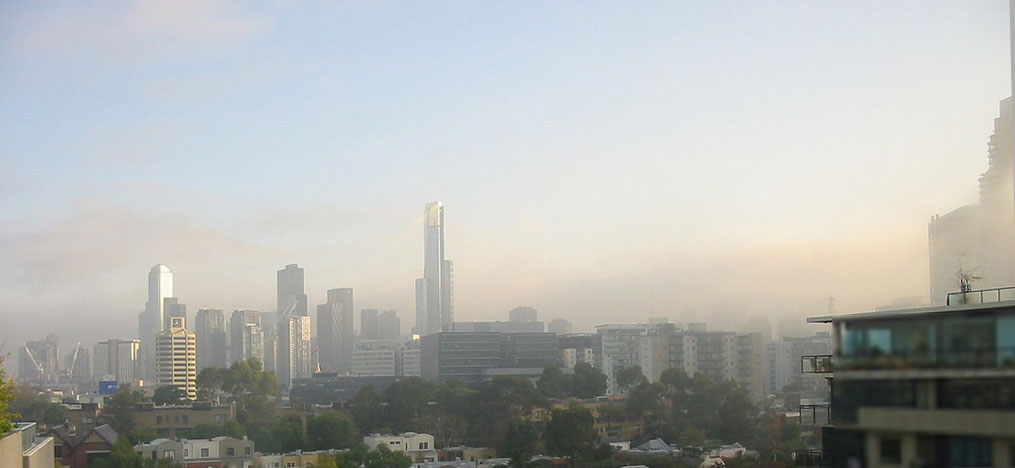
Webcam photos of Melbourne skyline courtesy of Dan Vogel, www.melbournephotos.net.au
COMET Sponsors
The COMET® Program is sponsored by NOAA National Weather Service (NWS), with additional funding by:
- Air Force Weather (AFW)
- Australian Bureau of Meteorology (BoM)
- European Organisation for the Exploitation of Meteorological Satellites (EUMETSAT)
- Meteorological Service of Canada (MSC)
- National Environmental Education Foundation (NEEF)
- National Polar-orbiting Operational Environmental Satellite System (NPOESS)
- NOAA National Environmental Satellite, Data and Information Service (NESDIS)
- Naval Meteorology and Oceanography Command (NMOC)
Project Contributors
Principal Science Advisors
- Kirsty Turner — BoM
- Monica Long — BoM
- Roger Deslandes — BoM
Project Lead and Instructional Design
- Bruce Muller — UCAR/COMET
Graphics/Interface Design
- Brannan McGill — UCAR/COMET
Multimedia Authoring
- Dan Riter — UCAR/COMET
Audio Editing/Production
- Seth Lamos — UCAR/COMET
Audio Narration
- Kirsty Turner — BoM
- Roger Deslandes — BoM
COMET HTML Integration Team 2020
- Tim Alberta — Project Manager
- Dolores Kiessling — Project Lead
- Steve Deyo — Graphic Artist
- Gary Pacheco — Lead Web Developer
- Justin Richling — Web Developer
- David Russi — Translations
- Gretchen Throop Williams — Web Developer
- Tyler Winstead — Web Developer
COMET Staff, January 2009
Director
- Dr. Timothy Spangler
Deputy Director
- Dr. Joe Lamos
Administration
- Elizabeth Lessard, Administration and Business Manager
- Lorrie Alberta
- Michelle Harrison
- Hildy Kane
Hardware/Software Support and Programming
- Tim Alberta, Group Manager
- Bob Bubon
- James Hamm
- Ken Kim
- Mark Mulholland
- Wade Pentz, Student
- Jay Shollenberger, Student
- Malte Winkler
Instructional Designers
- Dr. Patrick Parrish, Senior Project Manager
- Dr. Alan Bol
- Lon Goldstein
- Bryan Guarente
- Dr. Vickie Johnson
- Tsvetomir Ross-Lazarov
- Marianne Weingroff
Media Production Group
- Bruce Muller, Group Manager
- Steve Deyo
- Seth Lamos
- Brannan McGill
- Dan Riter
- Carl Whitehurst
Meteorologists/Scientists
- Dr. Greg Byrd, Senior Project Manager
- Wendy Schreiber-Abshire, Senior Project Manager
- Dr. William Bua
- Patrick Dills
- Dr. Stephen Jascourt
- Matthew Kelsch
- Dolores Kiessling
- Dr. Arlene Laing
- Dr. Elizabeth Mulvihill Page
- Amy Stevermer
- Warren Rodie
- Dr. Doug Wesley
Science Writer
- Jennifer Frazer
Spanish Translations
- David Russi
NOAA/National Weather Service - Forecast Decision Training Branch
- Anthony Mostek, Branch Chief
- Dr. Richard Koehler, Hydrology Training Lead
- Brian Motta, IFPS Training
- Dr. Robert Rozumalski, SOO Science and Training Resource (SOO/STRC) Coordinator
- Ross Van Til, Meteorologist
- Shannon White, AWIPS Training
Meteorological Service of Canada Visiting Meteorologists
- Phil Chadwick
- Jim Murtha