Media elements used in this module are protected by a variety of copyright licenses. Please use the "copyright terms" link associated with each item below for more information.
Description:
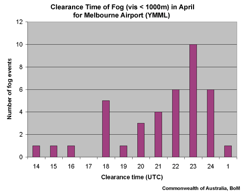
Clearance time of fog (visibility less than 1000 m) in April for Melbourne Airport (YMML)
File Name:
fog_clearance_ymml_april.gif
Credits:
Commonwealth of Australia, Bureau of Meteorology
Copyright Terms:
COMET Standard Terms
of Use
Description:
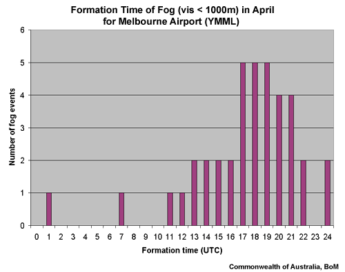
Formation time of fog (visibility less than 1000 metres) in April for Melbourne Airport (YMML)
File Name:
fog_formationtime_ymml_april.gif
Credits:
Commonwealth of Australia, Bureau of Meteorology
Copyright Terms:
COMET Standard Terms
of Use
Description:
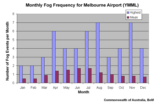
Monthly fog frequency for Melbourne Airport (YMML)
File Name:
fog_frequency_ymml.gif
Credits:
Commonwealth of Australia, Bureau of Meteorology
Copyright Terms:
COMET Standard Terms
of Use
Description:
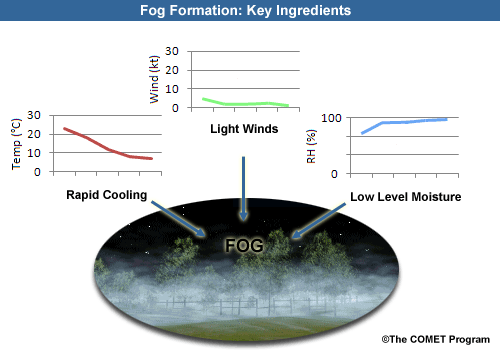
Fog formation ingredients
File Name:
fog_ingredients.gif
Credits:
©The COMET Program
Copyright Terms:
COMET Standard Terms
of Use
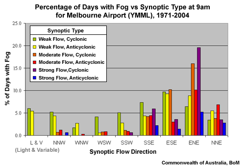
Description:
Percentage of days with fog versus the synoptic type at 9am for Melbourne Airport (YMML).
File Name:
fog_synoptictype_ymml.gif
Credits:
Commonwealth of Australia, Bureau of Meteorology
Copyright Terms:
COMET Standard Terms
of Use
Description:
Map of Australia
File Name:
map_australia.gif
Credits:
Commonwealth of Australia, Bureau of Meteorology
Copyright Terms:
COMET Standard Terms
of Use
Description:
Map of the region around Melbourne, Victoria, Australia
File Name:
map_melbourne.gif
Credits:
Commonwealth of Australia, Bureau of Meteorology
Copyright Terms:
COMET Standard Terms
of Use

Description:
Map of the region around Melbourne, Victoria, Australia showing four airports.
File Name:
map_melbourne_airports.gif
Credits:
Commonwealth of Australia, Bureau of Meteorology
Copyright Terms:
COMET Standard Terms
of Use
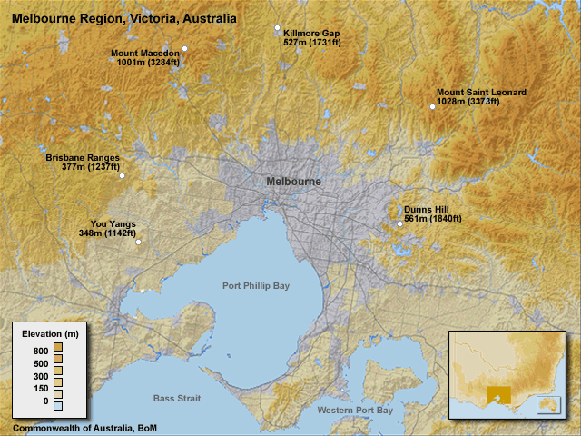
Description:
Map of the region around Melbourne, Victoria, Australia showing the location of the region's highest hills.
File Name:
map_melbourne_hills.gif
Credits:
Commonwealth of Australia, Bureau of Meteorology
Copyright Terms:
COMET Standard Terms
of Use
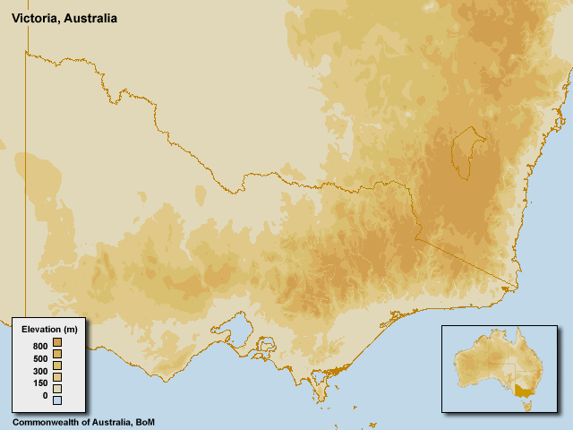
Description:
Map of the Victoria, Australia
File Name:
map_victoria.gif
Credits:
Commonwealth of Australia, Bureau of Meteorology
Copyright Terms:
COMET Standard Terms
of Use
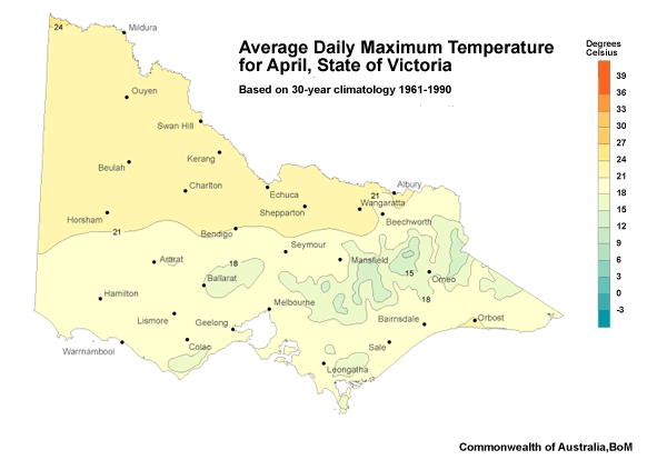
Description:
Average daily maximum temperature for April, for the State of Victoria based on 30-year climatology from 1961 to 1990.
File Name:
temp_averagemax_vic.gif
Credits:
Commonwealth of Australia, Bureau of Meteorology
Copyright Terms:
COMET Standard Terms
of Use
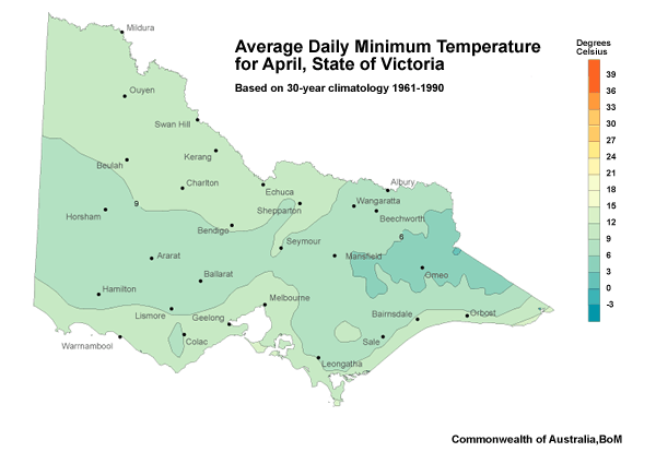
Description:
Average daily minimum temperature for April, for the State of Victoria based on 30-year climatology from 1961 to 1990.
File Name:
temp_averagemin_vic.gif
Credits:
Commonwealth of Australia, Bureau of Meteorology
Copyright Terms:
COMET Standard Terms
of Use
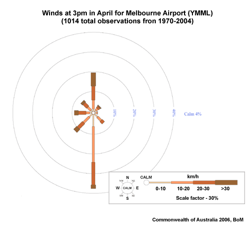
Description:
Winds at 3pm in April for Melbourne Airport (YMML) based on 1019 observations from 1970 to 2004.
File Name:
windrose_3pm_ymml_april.gif
Credits:
Commonwealth of Australia, Bureau of Meteorology
Copyright Terms:
COMET Standard Terms
of Use
Description:
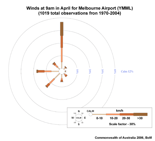
Winds at 9am in April for Melbourne Airport (YMML) based on 1019 observations from 1970 to 2004.
File Name:
windrose_9am_ymml_april.gif
Credits:
Commonwealth of Australia, Bureau of Meteorology
Copyright Terms:
COMET Standard Terms
of Use