Media elements used in this module are protected by a variety of copyright licenses. Please use the "copyright terms" link associated with each item below for more information.
Description:
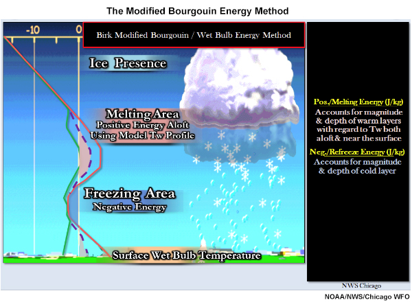
The Modified Bourgouin Energy Method
File Name:
Bourgouin_ptype_elements.jpg
Credits:
NOAA/NWS/Chicago WFO
Copyright Terms:
COMET Standard Terms
of Use
Description:
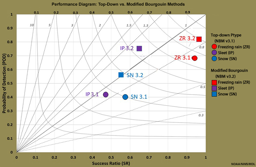
The Modified Bourgouin Energy Method
File Name:
bourgouin_v_topdown_verif.jpg
Credits:
NOAA/NWS/MDL
Copyright Terms:
COMET Standard Terms
of Use
Description:
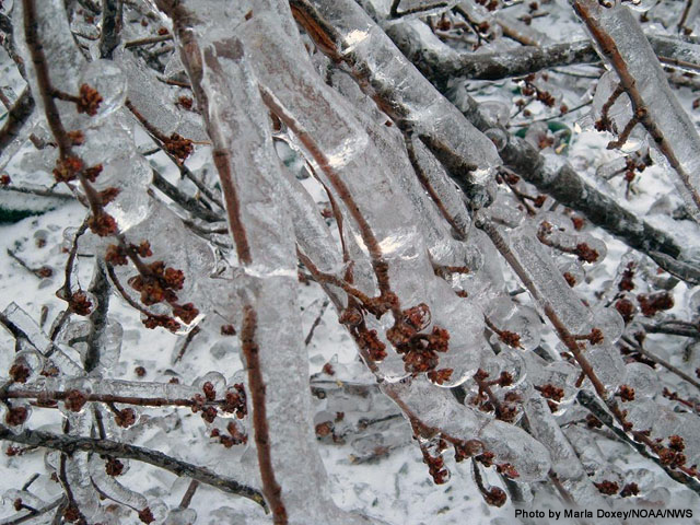
Photo of ice accumulation on branches
File Name:
Dec_31_closeupiceonbranches.jpg
Credits:
Photo by Marla Doxey/NOAA/NWS
Copyright Terms:
COMET Standard Terms
of Use
Description:
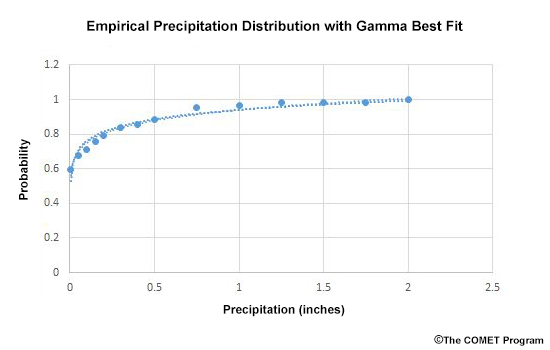
Illustration of Quantile Mapping and Dressing (QMD) applied to a cumulative distribution function (CDF) for precipitation.
File Name:
gamma.jpg
Credits:
(c) The COMET Program
Copyright Terms:
COMET Standard Terms
of Use

Description:
PoP12 Brier scores for Gamma/QMD method for NBM v3.1 (blue) vs NBM v32 (red) Relative to URMA (left) and METARs (right). NBM CONUS Domain, Apr-Jun 2019.
File Name:
gamma_pop12_urma_metar.jpg
Credits:
NOAA / NWS / MDL
Copyright Terms:
COMET Standard Terms
of Use
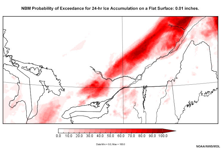
Description:
NBM Probability of Exceedance for 24-hr Ice Accumulation on a Flat Surface: 0.01, 0.25, 0.50, and 1.00 inches.
File Name:
ice24prbexceed_01.htm
Credits:
NOAA/NWS/MDL
Copyright Terms:
COMET Standard Terms
of Use

Description:
NBM Probabilistic 24-HR Ice Accumulation on a Flat Surface: Mean (upper-left), 10th Percentile (upper-right), 50th Percentile (lower-left), and 90th Percentile (lower-right). 36-hr Forecast valid 12 UTC 15 Mar 2019.
File Name:
mean_P10P50P90_ice24.jpg
Credits:
NOAA/NWS/MDL
Copyright Terms:
COMET Standard Terms
of Use

Description:
NBM Probabilistic 24-HR Snow Accumulation: Mean (upper-left), 10th Percentile (upper-right), 50th Percentile (lower-left), and 90th Percentile (lower-right). Forecast valid 00 UTC 24 Mar 2019.
File Name:
mean_P10P50P90_snow24.jpg
Credits:
NOAA/NWS/MDL
Copyright Terms:
COMET Standard Terms
of Use
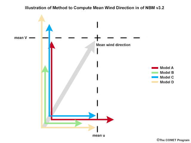
Description:
A visualization of the Method to Compute Mean Wind Direction in of NBM v3.2
File Name:
mean_wind_nbmv32.jpg
Credits:
(c) The COMET Program
Copyright Terms:
COMET Standard Terms
of Use

Description:
Snowy winter landscape
File Name:
module-cover.jpg
Credits:
creative commons Christopher
Copyright Terms:
Creative
Commons Attribution-Noncommercial 2.0 Generic
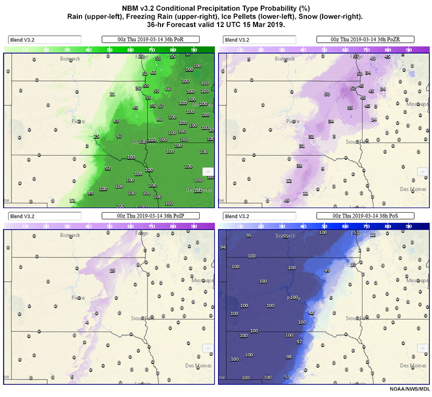
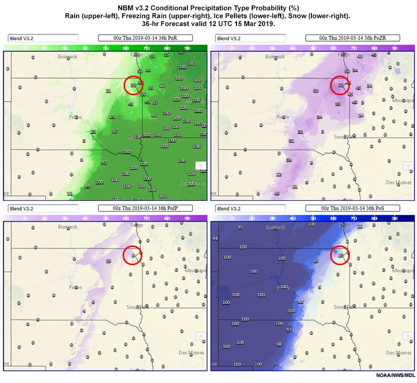
Description:
NBM Conditional Probability (%) of Rain (upper-left), Freezing Rain (upper-right), Ice Pellets (lower-left), Snow (lower-right). 36-hr Forecast valid 12 UTC 15 Mar 2019.
File Name:
nbm_ptype.jpg
Credits:
NOAA/NWS/MDL
Copyright Terms:
COMET Standard Terms
of Use

Description:
NBM Conditional Probability (%) of Rain (upper-left), Freezing Rain (upper-right), Ice Pellets (lower-left), Snow (lower-right). 36-hr Forecast valid 12 UTC 15 Mar 2019.
File Name:
nbm_ptype_q1.jpg
Credits:
NOAA/NWS/MDL
Copyright Terms:
COMET Standard Terms
of Use
Description:
NBM Conditional Probability (%) of Rain (upper-left), Freezing Rain (upper-right), Ice Pellets (lower-left), Snow (lower-right). 36-hr Forecast valid 12 UTC 15 Mar 2019.
File Name:
nbm_ptype_q3.jpg
Credits:
NOAA/NWS/MDL
Copyright Terms:
COMET Standard Terms
of Use
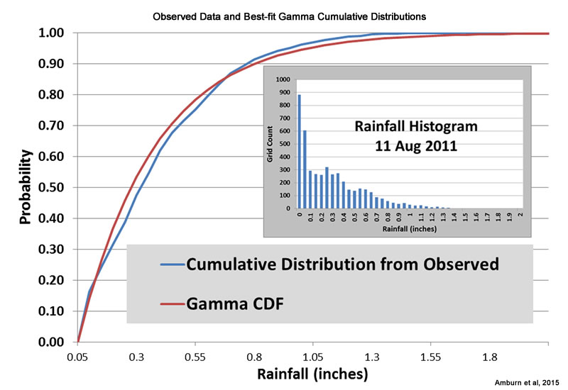
Description:
Cumulative distributions of observed data and the gamma approximation.
File Name:
obs_gamma_cdf.jpg
Credits:
Amburn et al. 2015
Copyright Terms:
COMET Standard Terms
of Use
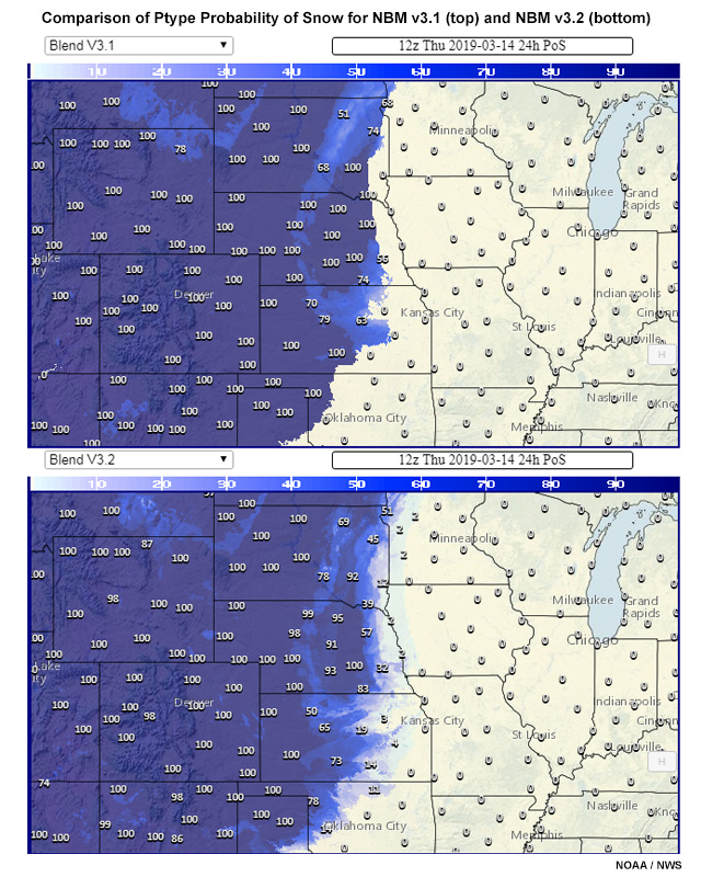
Description:
NBM v3.1 (top) shows a sharp boundary between 0% and 100% probability of snow along much of its eastern edge, while NBM 3.2 (bottom) shows a wider transition zone.
File Name:
popsnow_v31_v32.jpg
Credits:
NOAA / NWS
Copyright Terms:
COMET Standard Terms
of Use
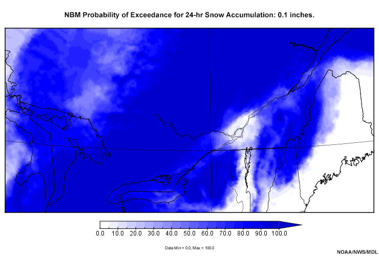
Description:
NBM Probability of Exceedance for 24-hr Snow Accumulation: 0.1, 1.0, 2.0, 4.0, 6.0, 8.0, 12.0, 18.0, 30.0 inches.
File Name:
s24prbexceed_01.htm
Credits:
NOAA/NWS/MDL
Copyright Terms:
COMET Standard Terms
of Use
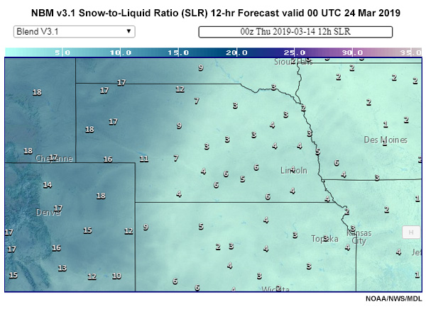
Description:
NBM v3.1 Snow to Liquid Ratio (SLR). 12-hr Forecast valid 00 UTC 24 Mar 2019
File Name:
SLR_v31.jpg
Credits:
NOAA/NWS/MDL
Copyright Terms:
COMET Standard Terms
of Use

Description:
NBM v3.2 Snow to Liquid Ratio (SLR). 12-hr Forecast valid 00 UTC 24 Mar 2019
File Name:
SLR_v32.jpg
Credits:
NOAA/NWS/MDL
Copyright Terms:
COMET Standard Terms
of Use
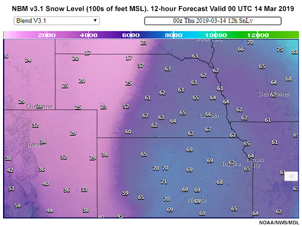
Description:
NBM Snow Level (100s of feet MSL). v3.1 (top) and v3.2 (bottom). 12-hour Forecast Valid 00 UTC 14 Mar 2019
File Name:
SnLv_v31.jpg
Credits:
NOAA/NWS/MDL
Copyright Terms:
COMET Standard Terms
of Use
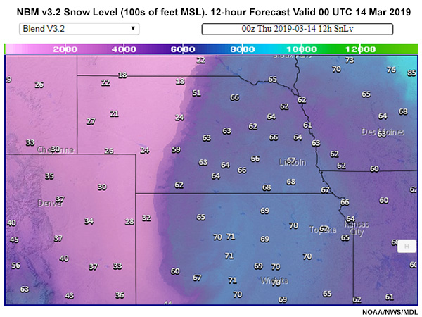
Description:
NBM v3.2 Snow Level (100s of feet MSL). 12-hour Forecast Valid 00 UTC 14 Mar 2019
File Name:
SnLv_v32.jpg
Credits:
NOAA/NWS/MDL
Copyright Terms:
COMET Standard Terms
of Use
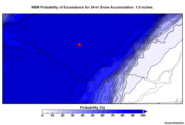
Description:
NBM Probability of Exceedance for 24-hr Snow Accumulation: 1.0, 2.0, 4.0, 6.0, 8.0, 12.0 inches.
File Name:
snow24prbexceed_q_01.htm
Credits:
NOAA/NWS/MDL
Copyright Terms:
COMET Standard Terms
of Use
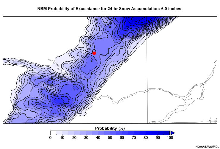
Description:
NBM Probability of Exceedance for 24-hr Snow Accumulation: 6.0 inches.
File Name:
snow24prbexceed_q_04.jpg
Credits:
NOAA/NWS/MDL
Copyright Terms:
COMET Standard Terms
of Use
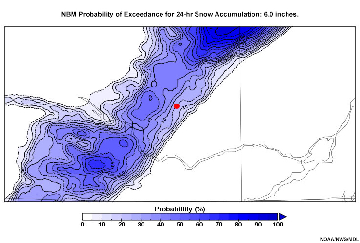
Description:
NBM Probability of Exceedance for 24-hr Snow Accumulation: 6.0 inches.
File Name:
snow24prbexceed_q_04b.jpg
Credits:
NOAA/NWS/MDL
Copyright Terms:
COMET Standard Terms
of Use
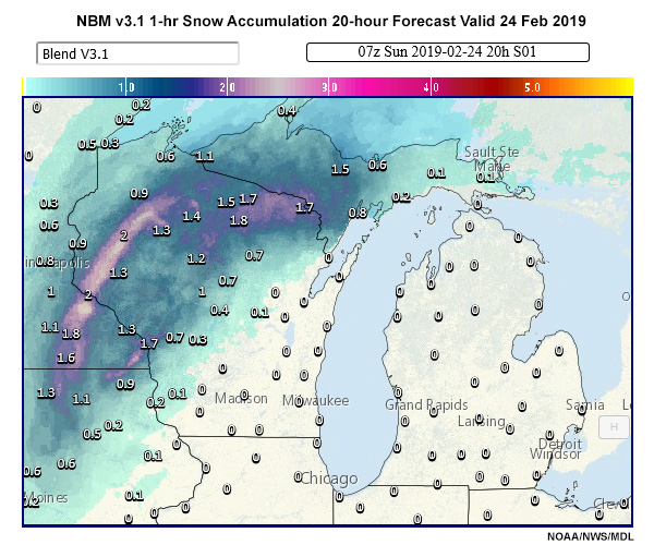
Description:
One-Hour Snow Accumulation Comparison: NBM v3.1 (top) versus NBM v3.2 (bottom). 20-hour Forecasts Valid 24 Feb 2019
File Name:
SnowAmt01_v31.jpg
Credits:
NOAA/NWS/MDL
Copyright Terms:
COMET Standard Terms
of Use
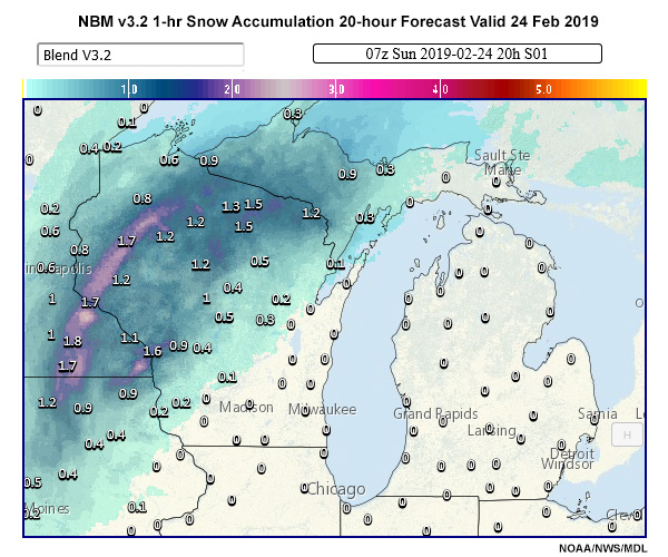
Description:
NBM v3.2 1-hr Snow Accumulation Comparison. 20-hour Forecasts Valid 24 Feb 2019
File Name:
SnowAmt01_v32.jpg
Credits:
NOAA/NWS
Copyright Terms:
COMET Standard Terms
of Use
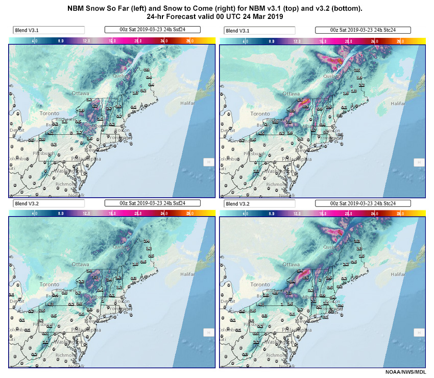
Description:
NBM Snow Snow So Far (left) and Snow to Come (right) for NBM v3.1 (top) and v3.2 (bottom). 24-Hour Forecast valid Forecast Valid 00 UTC 24 Mar 2019
File Name:
snowsofar_snowtocome.jpg
Credits:
NOAA/NWS/MDL
Copyright Terms:
COMET Standard Terms
of Use
Description:
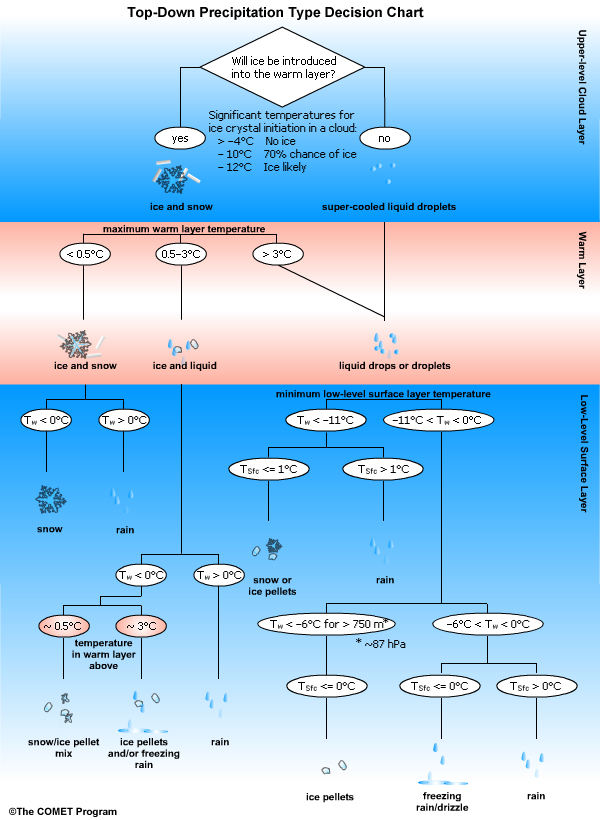
Decision tree for applying top-down method for precipitation type forecasting.
File Name:
topdown_chart.jpg
Credits:
(c) The COMET Program
Copyright Terms:
COMET Standard Terms
of Use