Media elements used in this module are protected by a variety of copyright licenses. Please use the "copyright terms" link associated with each item below for more information.
Description:
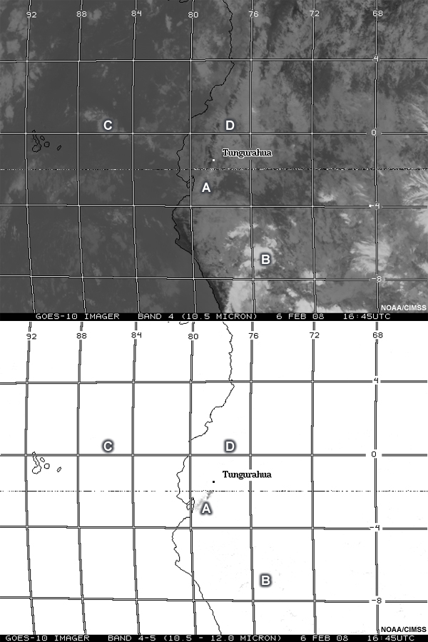
The Imager 10.5µm “IR window”, the Imager 10.5-12.0µm “split window difference” during the Tungurahua volcano eruption.
File Name:
080206_g10_imager_sounder_anim.jpg
Credits:
NOAA/CIMSS
Copyright Terms:
COMET Standard Terms of Use
Description:
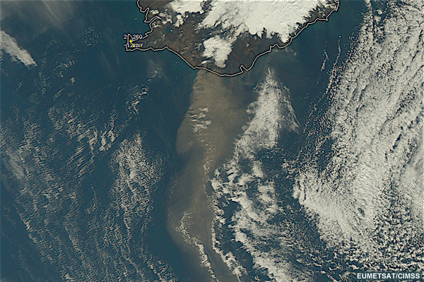
A McIDAS Red/Green/Blue (RGB) image composite using Aqua MODIS channels 01/04/03 reveals yet another large ash plume streaming southward over the North Atlantic Ocean from Eyjafjallajokull on April 19, 2011.
File Name:
100419_1305Z_MODIS_RGB_CH010403_2.jpg
Credits:
EUMETSAT/CIMSS
Copyright Terms:
COMET Standard Terms of Use
Description:
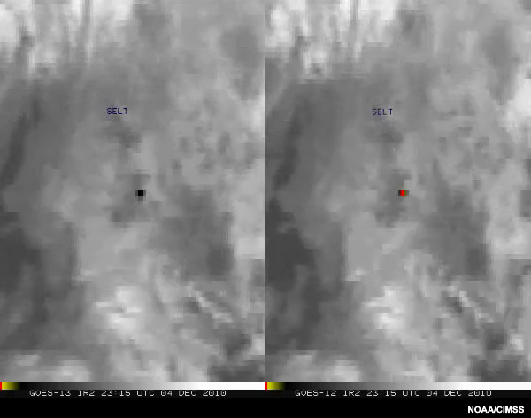
The loop reveals the “hot spot” (yellow to red color enhancement) due to the eruption of the Tungurahua volcano in the South American country of Ecuador on 04 December 2010.
File Name:
101204_g13_g12_swir_anim.mp4
Credits:
NOAA/CIMSS
Copyright Terms:
COMET Standard Terms of Use
Description:
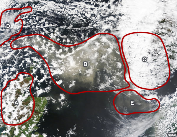
RGB image containing five possible areas where volcanic ash can be present.
File Name:
552588main_northsea_tmo_2011144_quiz.jpg
Credits:
NASA
Copyright Terms:
COMET Standard Terms of Use
Description:
RGB image containing areas of volcanic ash.
File Name:
556896main_20110606_chile_img3_quiz.jpg
Credits:
NASA
Copyright Terms:
COMET Standard Terms of Use
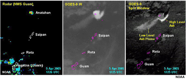
Description:
Comparison of GOES-9 10.7 micron thermal IR (left), and the split window image (right) at around 1725 UTC, 5 April 2005. The Anatahan Volcano in the Marianas Islands in the Western Pacific Ocean erupted on 5 April 2005, producing a dense ash cloud that rose to 51,000 ft.
File Name:
anat_3pn_radsat2.jpg
Credits:
NOAA
Copyright Terms:
COMET Standard Terms of Use
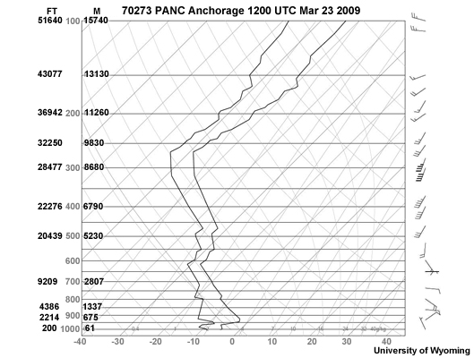
Description:
A sounding from Anchorage on March 23, 2009 during Mt Redoubt's eruption.
File Name:
anc_sounding_plot_23Mar12z.jpg
Credits:
University of Wyoming
Copyright Terms:
COMET Standard Terms of Use
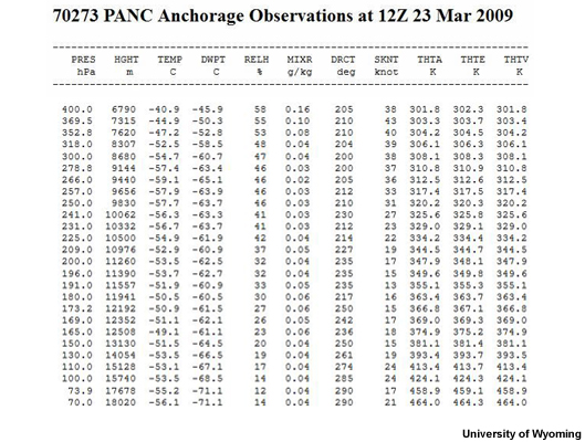
Description:
The text values of a sounding from Anchorage on March 23, 2009 during Mt Redoubt's eruption.
File Name:
anc_sounding_txt_23Mar12z.jpg
Credits:
University of Wyoming
Copyright Terms:
COMET Standard Terms of Use
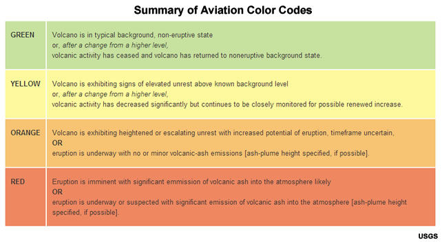
Description:
table summarizing Aviation Color Codes and their meanings for volcanic events
File Name:
aviationcolorcodes_usgs.jpg
Credits:
USGS
Copyright Terms:
COMET Standard Terms of Use
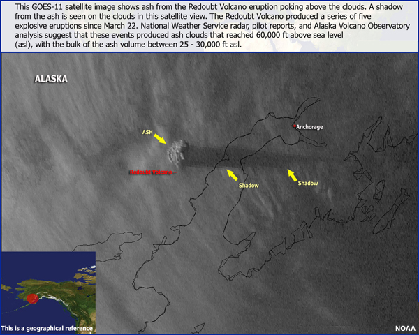
Description:
A GOES-11 satellite image shows the ash plume and its shadow from a series of explosive eruptions on Mt Redoubt on March 22, 2009.
File Name:
base6444f92776f16ffa66.jpg
Credits:
NOAA
Copyright Terms:
COMET Standard Terms of Use
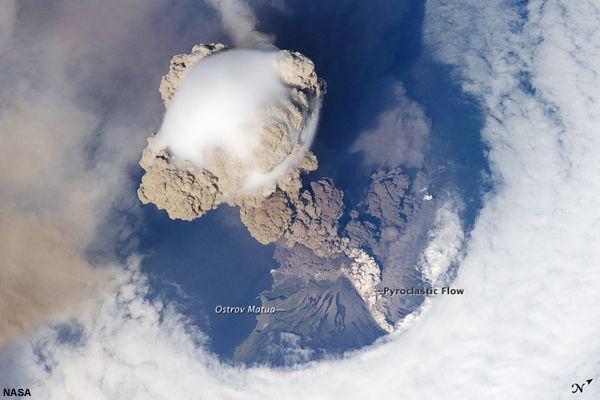
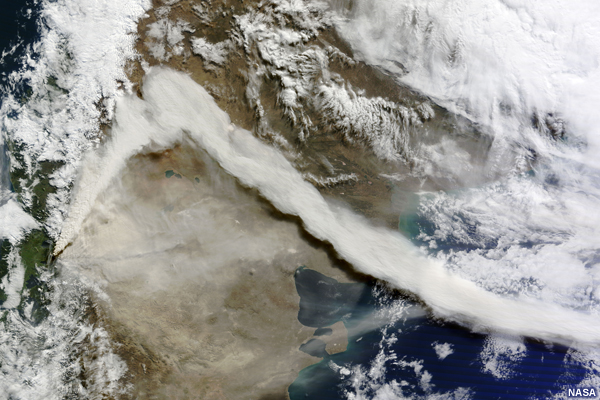
Description:
This is a view from space of the eruption of Sarychev volcano. The plume appears to be a combination of brown ash and white steam. The vigorously rising plume gives the steam a bubble-like appearance.
File Name:
eruption_from_space_lrg.jpg
Credits:
NASA
Copyright Terms:
COMET Standard Terms of Use

Description:
Landsat-8 True Color Image of Volcán de Fuego Eruption on 3 Feb 2018
File Name:
fuego_oli_2018032_wide.jpg
Credits:
NASA
Copyright Terms:
COMET Standard Terms of Use
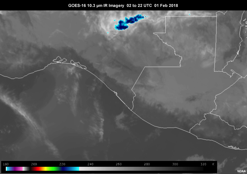
Description:
GOES-16 10.3 µm IR loop of Volcan de Fuego eruption from 02 to 22 UTC on 01 Feb 2018
File Name:
g16_103ir_fuego_01feb18_ani.mp4
Credits:
NOAA
Copyright Terms:
COMET Standard Terms of Use
Description:
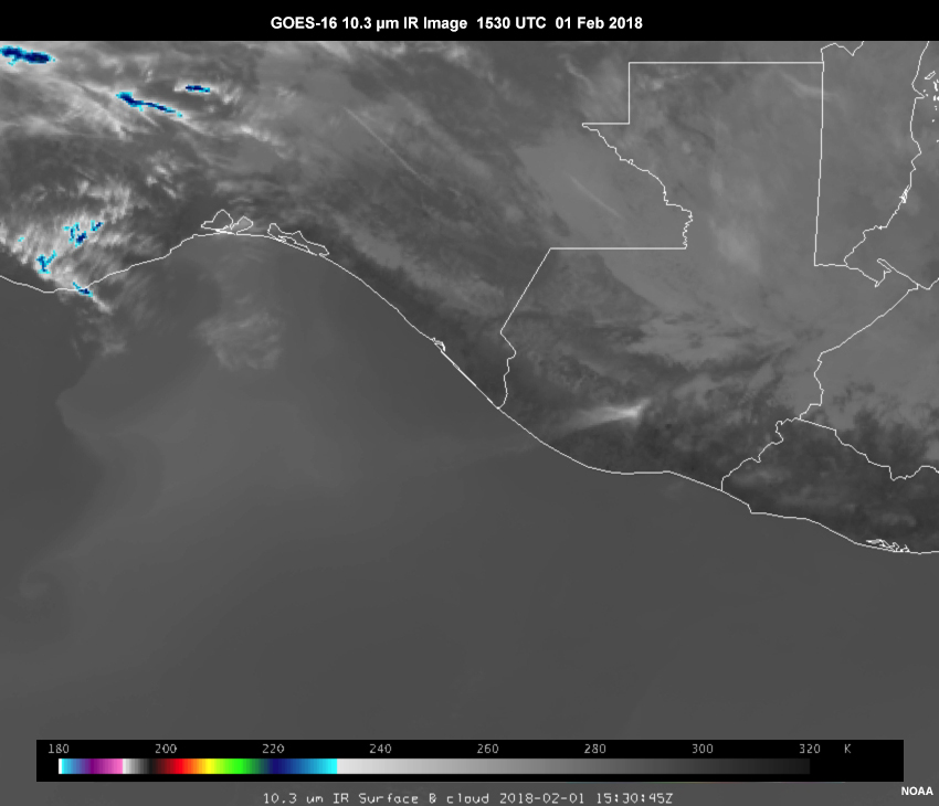
GOES-16 IR band 10.3 image of Volcan de Fuego eruption at 1530 UTC 01 Feb 2018
File Name:
g16_103ir_fuego_01feb18_ani_f55.jpg
Credits:
NOAA
Copyright Terms:
COMET Standard Terms of Use
Description:
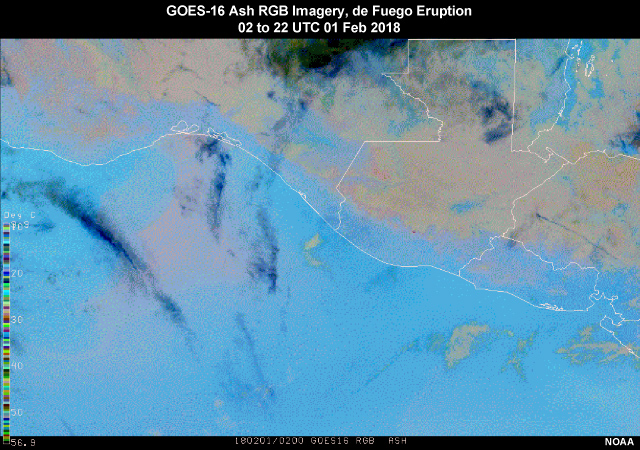
GOES-16 Ash RGB loop of the Volcan de Fuego eruption from 02 to 22 UTC 01 Feb 2018
File Name:
g16_ash_rgb_fuego_20180201_v2_ani.mp4
Credits:
NOAA
Copyright Terms:
COMET Standard Terms of Use
Description:
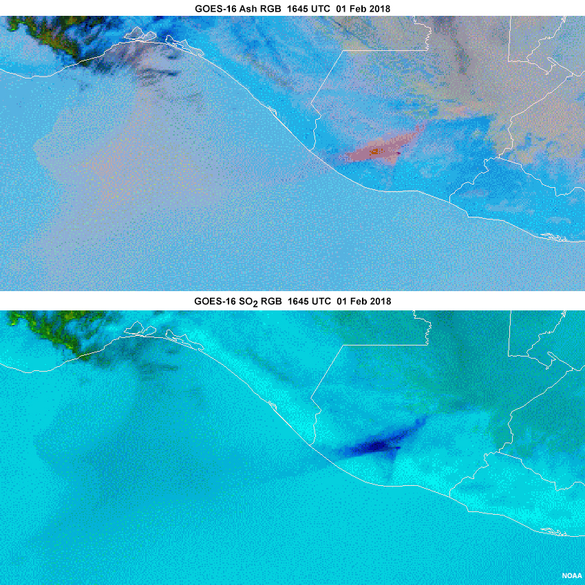
GOES-16 Ash RGB and SO2 RGB imagery of the de Fuego eruption from 1645 UTC 01 Feb 2018
File Name:
g16_ash_so2_rgb_2panel_fuego.jpg
Credits:
NOAA
Copyright Terms:
COMET Standard Terms of Use
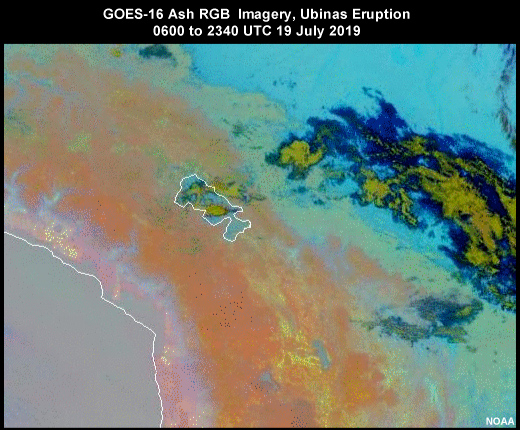
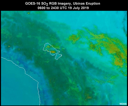
Description:
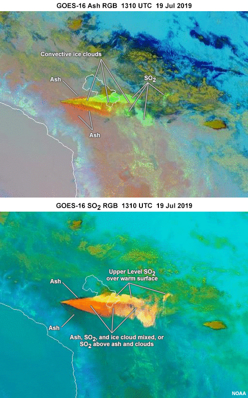
GOES-16 Ash RGB and SO2 RGB imagery of the Ubinas eruption from 1301 UTC 19 July 2019
File Name:
g16_ash_so2_rgb_2panel_ubinas.jpg
Credits:
NOAA
Copyright Terms:
COMET Standard Terms of Use
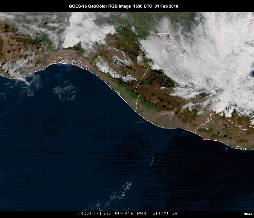
Description:
Geocolor image of Volcan de Fuego eruption
File Name:
g16_geocolor_fuego_20180201.jpg
Credits:
NOAA
Copyright Terms:
COMET Standard Terms of Use
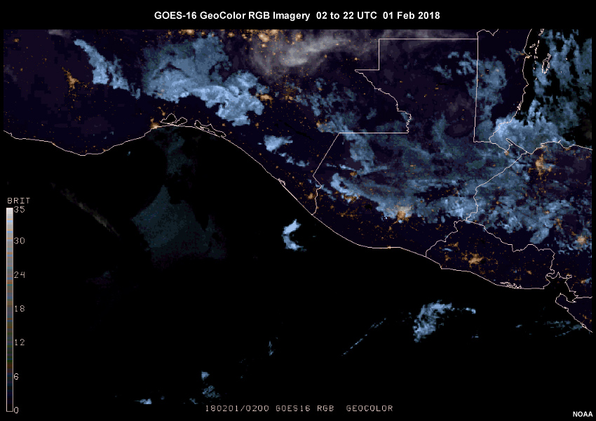
Description:
Geocolor loop of Volcan de Fuego eruption from 02 to 22 UTC on 01 Feb 2018
File Name:
g16_geocolor_fuego_20180201_v2_ani.mp4
Credits:
NOAA
Copyright Terms:
COMET Standard Terms of Use
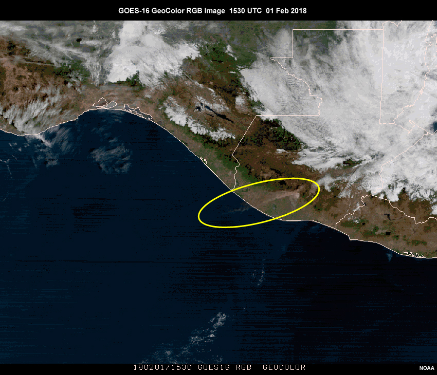
Description:
Geocolor image of Volcan de Fuego eruption with plume circled
File Name:
g16_geocolor_fuego_correct.jpg
Credits:
NOAA
Copyright Terms:
COMET Standard Terms of Use
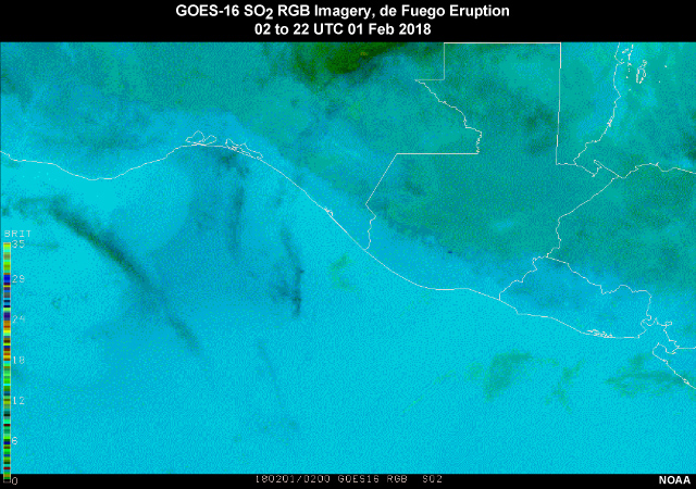
Description:
GOES-16 SO2 RGB loop from the Volcan de Fuego eruption 02 to 22 UTC 01 Feb 2018
File Name:
g16_so2_rgb_fuego_20180201_v2_ani.mp4
Credits:
NOAA
Copyright Terms:
COMET Standard Terms of Use
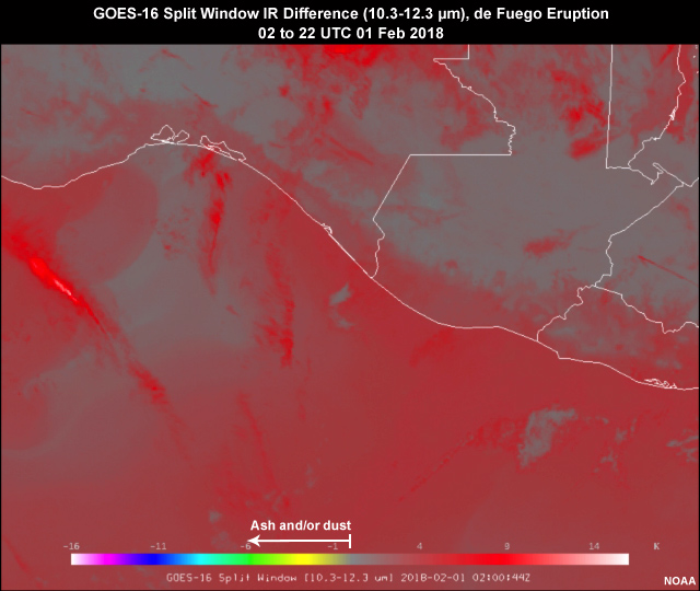
Description:
GOES-16 Split Window IR Difference (10.3-12.3 µm) loop of the de Fuego Eruption 02 to 22 UTC 01 Feb 2018
File Name:
g16_splitwinir_fuego_01feb18_ani.mp4
Credits:
NOAA
Copyright Terms:
COMET Standard Terms of Use
Description:
GOES-16 Ash RGB loop from 0600 to 2340 UTC 19 July 2019
File Name:
g16_ubinas_ash_rgb_19jul19_ani.mp4
Credits:
NOAA
Copyright Terms:
COMET Standard Terms of Use
Description:
GOES-16 SO2 RGB loop from 0600 to 2340 UTC 19 July 2019
File Name:
g16_ubinas_so2_rgb_19jul19_ani.mp4
Credits:
NOAA
Copyright Terms:
COMET Standard Terms of Use
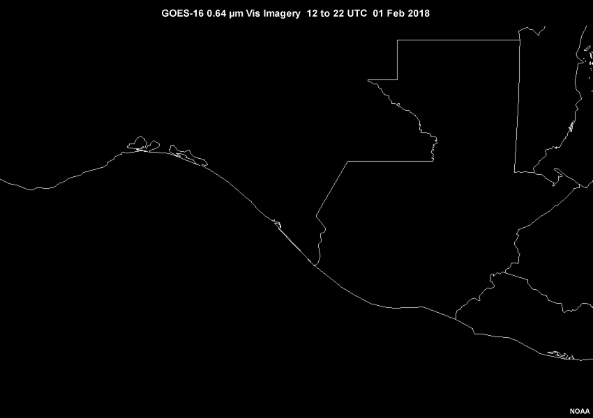
Description:
Visible imagery loop of Volcan de Fuego eruption from 12 to 22 UTC on 01 Feb 2018
File Name:
g16_vis2_fuego_01feb18_ani.mp4
Credits:
NOAA
Copyright Terms:
COMET Standard Terms of Use
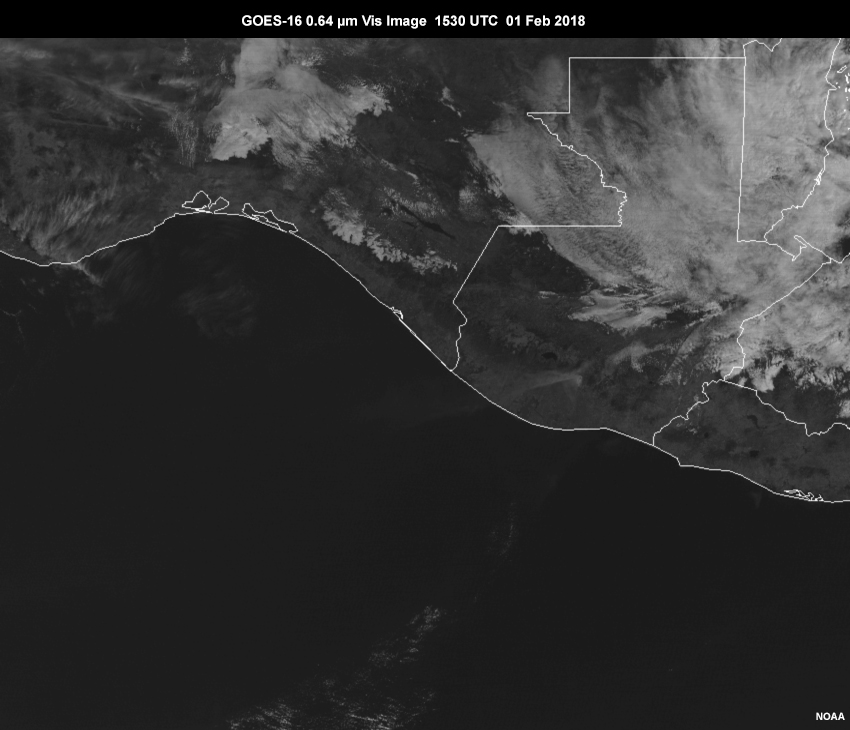
Description:
Visible image of Volcan de Fuego eruption at 1530 UTC 01 Feb 2018
File Name:
g16_vis2_fuego_1530_01feb18.jpg
Credits:
NOAA
Copyright Terms:
COMET Standard Terms of Use

Description:
Legends for the GOES Ash RGB and GOES SO2 RGB providing color interpretation
File Name:
goes_ash_so2_rgb_legend.jpg
Credits:
CIRA/NASA/NOAA
Copyright Terms:
COMET Standard Terms of Use
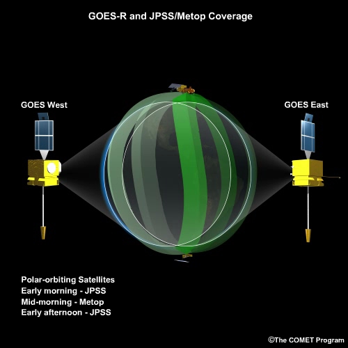
Description:
GOES-R and JPSS/Metop orbits and geographic coverage.
File Name:
goesr_jpss_orbit_system.mp4
Credits:
©The COMET Program
Copyright Terms:
COMET Standard Terms of Use
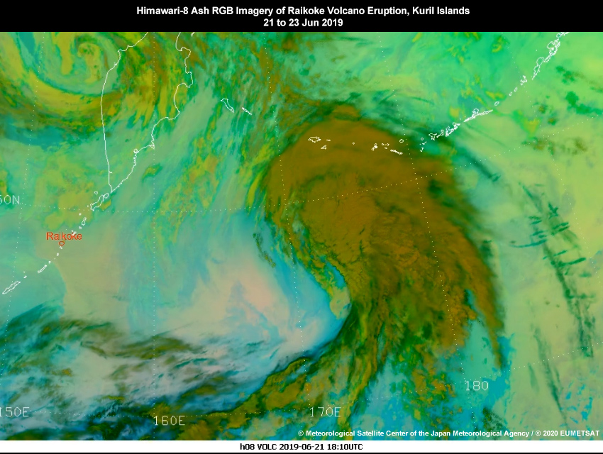
Description:
Himawari-8 Ash RGB imagery showing Raikoke volcano eruption, Kuril Islands 21 to 23 Jun 2019
File Name:
h8_raikoke_eruption_ashrgb_21jun19_ani.mp4
Credits:
© Meteorological Satellite Center of the Japan Meteorological Agency / © 2020 EUMETSAT
Copyright Terms:
COMET Standard Terms of Use
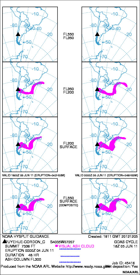
Description:
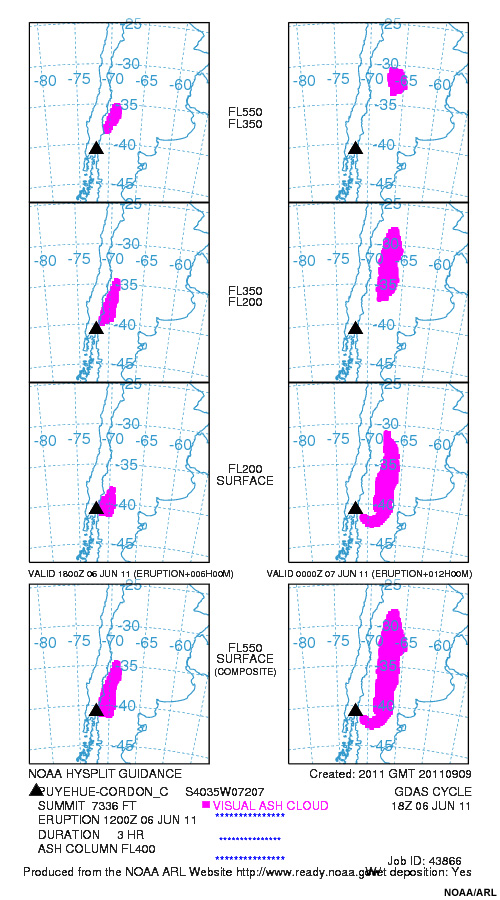
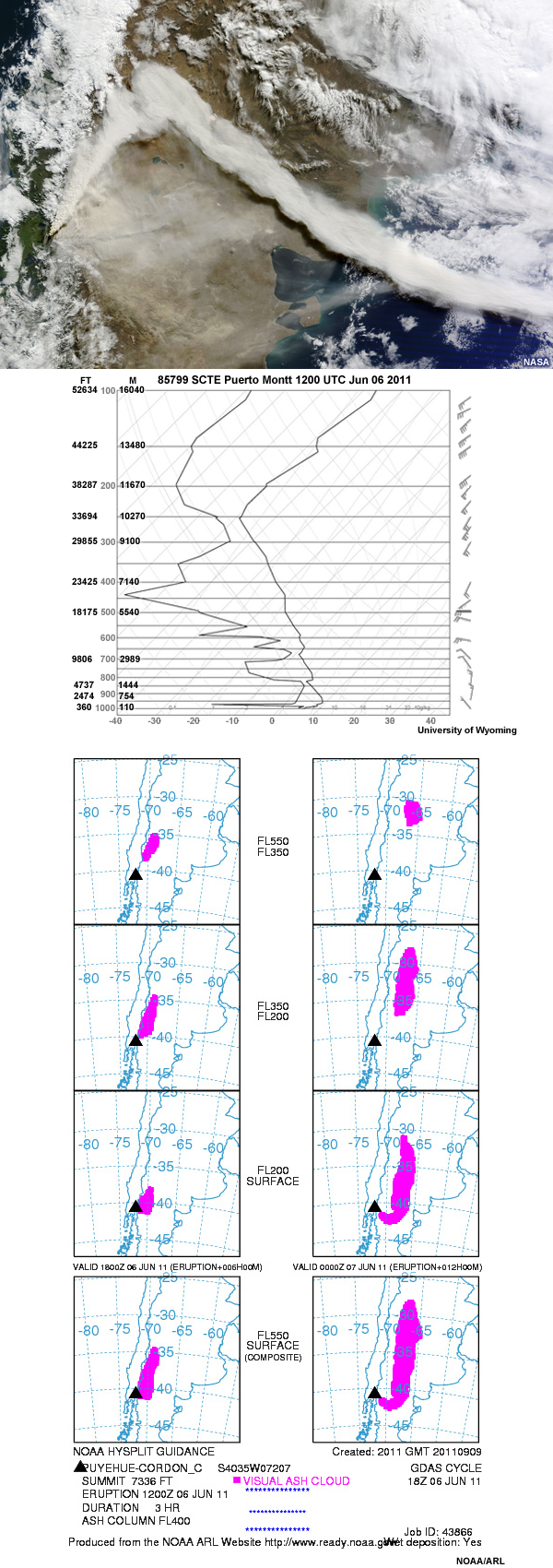
Hysplit volcanic ash model results for Puyehue Cordon-Caulle eruption, 2011 June 4
File Name:
hysplit_18Z_5jun2011.jpg
Credits:
NOAA/ARL
Copyright Terms:
COMET Standard Terms of Use
Description:
A HYSPLIT forecast of the possible spread of Puyehue-Cordón Caulle's volcanic ash plume.
File Name:
hysplitrun_quiz.jpg
Credits:
NOAA/ARL
Copyright Terms:
COMET Standard Terms of Use
Description:
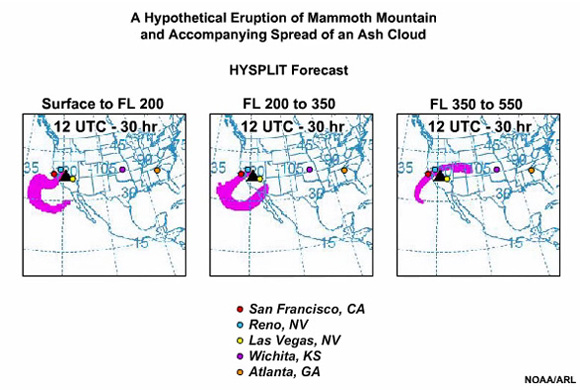
The animation shows the Hysplit forecast for the spread of an ash cloud to the west and east of Mammoth mountain after a hypothetical eruption.
File Name:
mammoth_hysplit.mp4
Credits:
NOAA/ARL
Copyright Terms:
COMET Standard Terms of Use
Description:
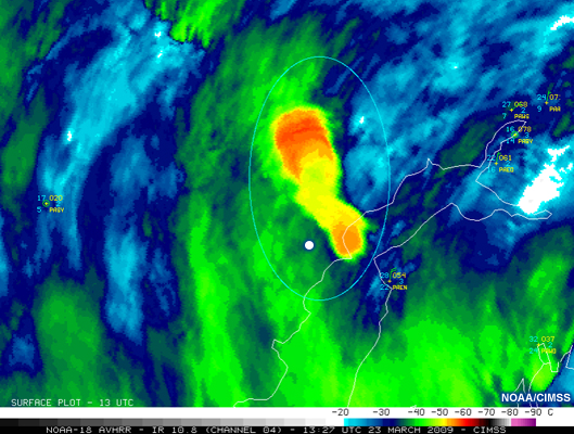
NOAA-17 10.8 µm IR image shows a Mt Redoubt eruption with a more dense plume feature that is spreading out in a NW-SE direction at 13:27 UTC on 23 March, 2009.
File Name:
mt_redoubt_temp.jpg
Credits:
NOAA/CIMSS
Copyright Terms:
COMET Standard Terms of Use
Description:
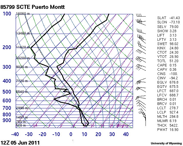
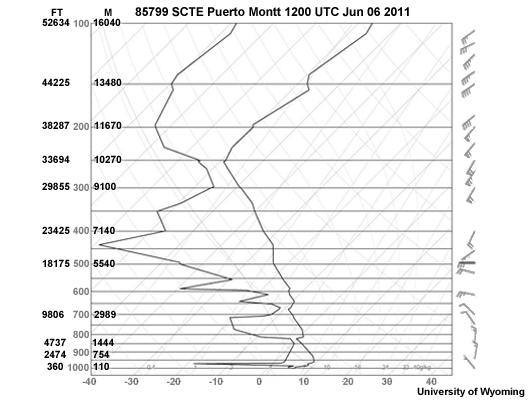
upper air sounding taken 12Z 05 June 2011 at Puerto Montt, Chile
File Name:
puerto_montt_2011060500.jpg
Credits:
University of Wyoming
Copyright Terms:
COMET Standard Terms of Use
Description:
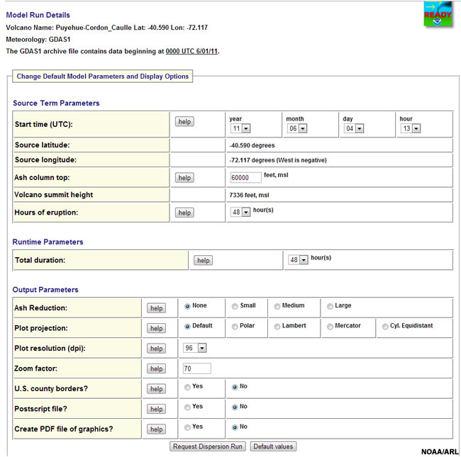
screen shot of HYSPLIT model interface for June 2011 Puyehue Cordon-Caulle eruption
File Name:
puyehue_hysplitInt.jpg
Credits:
NOAA/ARL
Copyright Terms:
COMET Standard Terms of Use
Description:
Image with three panels with the following information about the Puyehue-Cordón Caulle's eruption: first, RGB image containing areas of volcanic ash; a sounding from Puerto Mountain on June 6, 2011; and A HYSPLIT forecast of the possible plume spread.
File Name:
q11_image_quiz.jpg
Credits:
NASA/University of Wyoming/NOAA/ARL
Copyright Terms:
COMET Standard Terms of Use
Description:
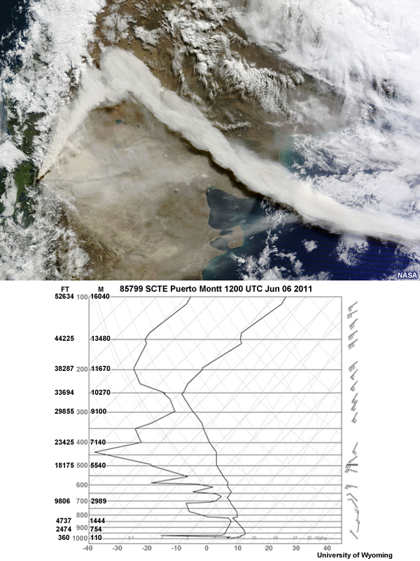
Image with two graphics. The top is an RGB image containing areas of volcanic ash. The bottom is A sounding from Puerto Mountain on June 6, 2011 during Puyehue-Cordón Caulle's eruption.
File Name:
q9_image_quiz.jpg
Credits:
NASA/ University of Wyoming
Copyright Terms:
COMET Standard Terms of Use
Description:
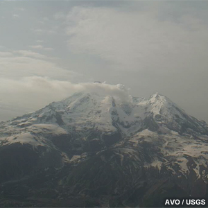
Short smoke plume drifts away from the crater of Mt. Redoubt on this webcam image.
File Name:
redoubt_webcam.jpg
Credits:
AVO / USGS
Copyright Terms:
COMET Standard Terms of Use
Description:
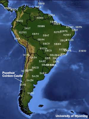
map of portion of Chile and southwest Argentina showing upper air stations and location of the Puyehue Cordon Caulle eruption in June 2011
File Name:
samer_upperair.jpg
Credits:
University of Wyoming
Copyright Terms:
COMET Standard Terms of Use
Description:
A sounding from Puerto Mountain on June 6, 2011 during Puyehue-Cordón Caulle's eruption.
File Name:
scte_sounding_plot06Jun12z.jpg
Credits:
University of Wyoming
Copyright Terms:
COMET Standard Terms of Use
Description:
Welcome to the Volcanic Ash: Observation Tools and Dispersion Models module
File Name:
splash_image.jpg
Credits:
NASA
Copyright Terms:
COMET Standard Terms of Use
Description:
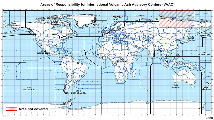
Map showing areas of responsibility for each of the nine international Volcanic Ash Advisory Centers (VAACs)
File Name:
vaac_areas_2020.jpg
Credits:
USGS
Copyright Terms:
COMET Standard Terms of Use
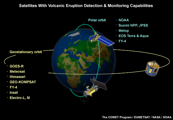
Description:
Environmental satellites with volcanic ash, hot spot, and SO2 detection and monitoring capabilities
File Name:
volcano_satellites_apr2020.jpg
Credits:
©The COMET Program, EUMETSAT, NASA, NOAA
Copyright Terms:
COMET Standard Terms of Use
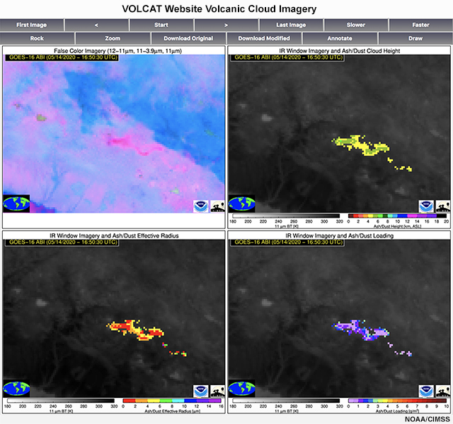
Description:
GOES-16 four-panel display from NOAA/CIMSS VOLCAT volcanic cloud monitoring website showing ash detection products for Sabancaya eruption in southern Peru on 14 May 2020.
File Name:
volcat_4panel_sab_peru_14may20.jpg
Credits:
NOAA/CIMSS
Copyright Terms:
COMET Standard Terms of Use