Media elements used in this module are protected by a variety of copyright licenses. Please use the "copyright terms" link associated with each item below for more information.
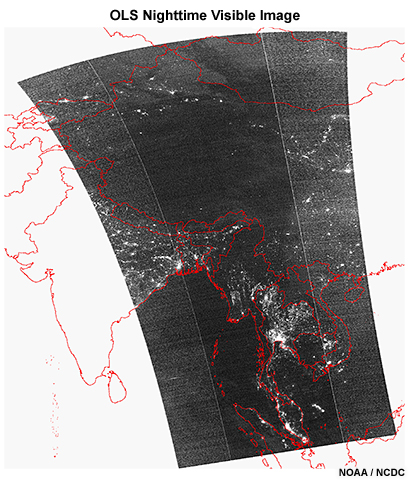
Description:
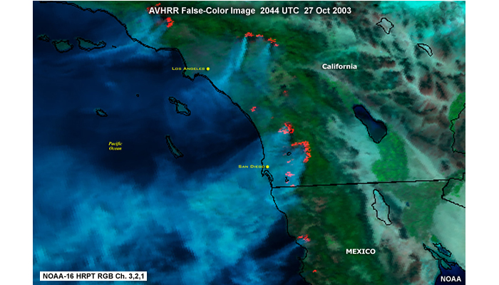
AVHRR false-color image of fires over Southern California and northwestern Mexio at 2044 UTC on October 27, 2003.
File Name:
avhrr_1_3.jpg
Credits:
NOAA
Copyright Terms:
COMET Standard Terms
of Use
Description:
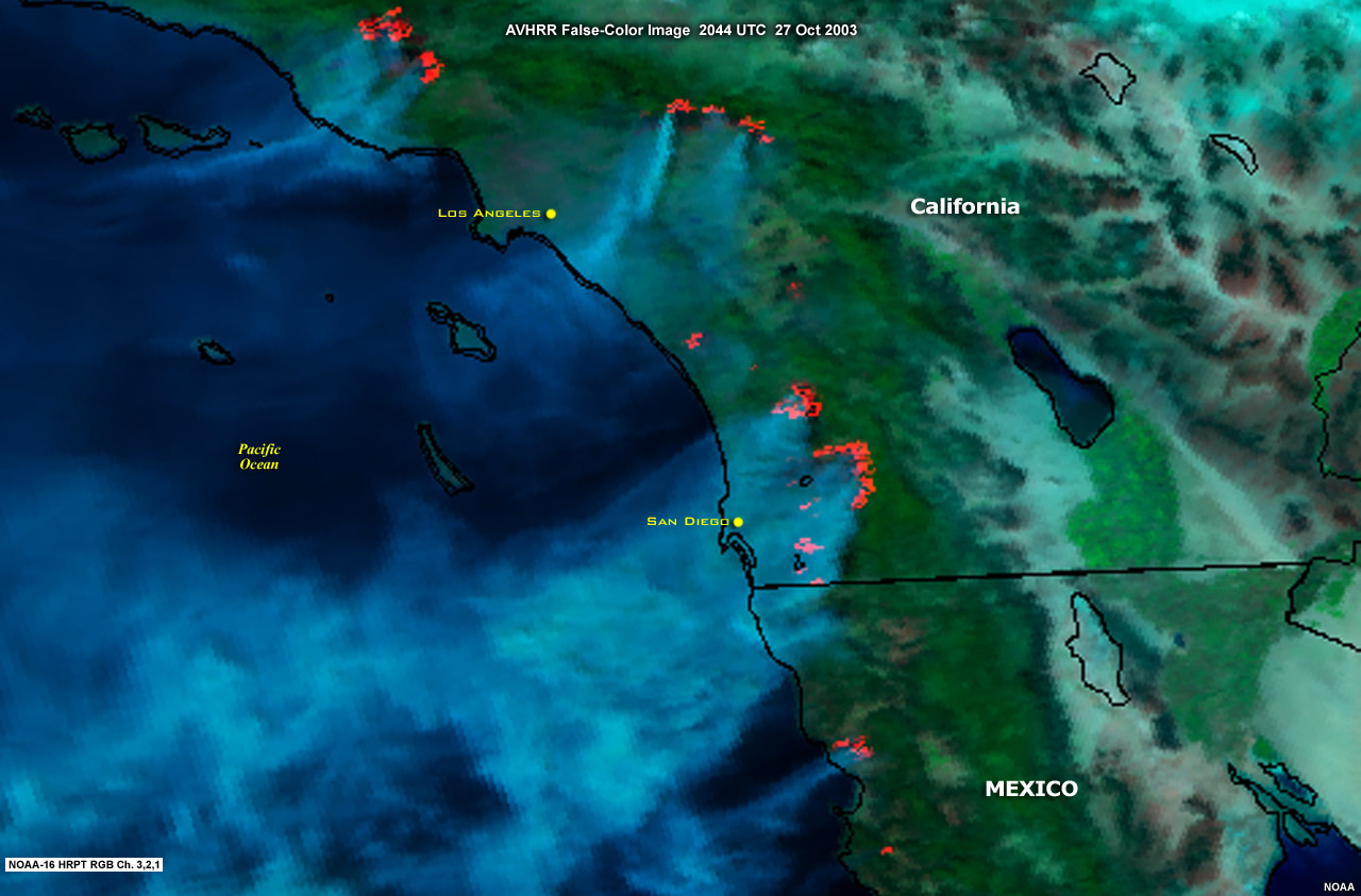
AVHRR false-color image of fires over Southern California and northwestern Mexio at 2044 UTC on October 27, 2003.
File Name:
avhrr_1_3_big.jpg
Credits:
NOAA
Copyright Terms:
COMET Standard Terms
of Use
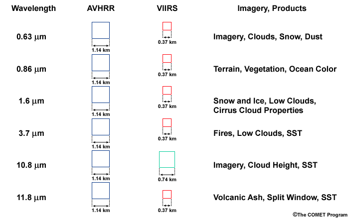
Description:
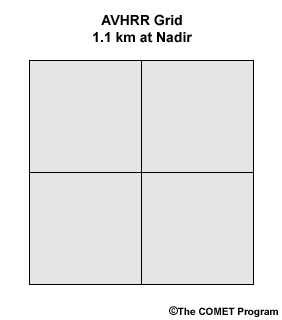
NOAA AVHRR channel grid, 1.1 km at nadir viewing angles.
File Name:
avhrr_2_3.gif
Credits:
©The COMET Program
Copyright Terms:
COMET Standard Terms
of Use
Description:
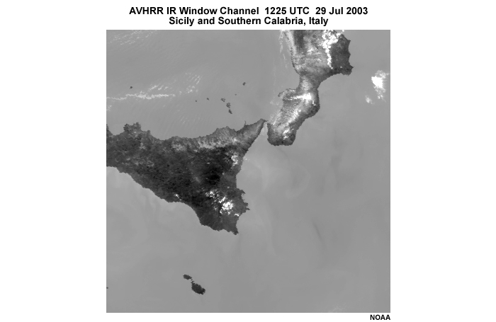
AVHRR 11 micrometer infrared windows channel image showing Sicily and southern Calabria, Italy at 1225 UTC on July 29, 2003.
File Name:
avhrr_2_5_ir.jpg
Credits:
NOAA
Copyright Terms:
COMET Standard Terms
of Use
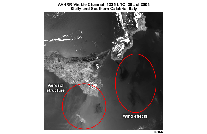
Description:
AVHRR visible channel image showing Sicily and southern Calabria, Italy at 1225 UTC on July 29, 2003.
File Name:
avhrr_2_5_vis_w_overlay.jpg
Credits:
NOAA
Copyright Terms:
COMET Standard Terms
of Use
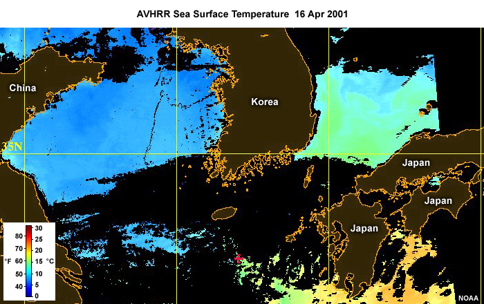
Description:
AVHRR sea surface temperature product across the East China Sea region on April 16, 2001.
File Name:
avhrr_2_6.jpg
Credits:
NOAA
Copyright Terms:
COMET Standard Terms
of Use
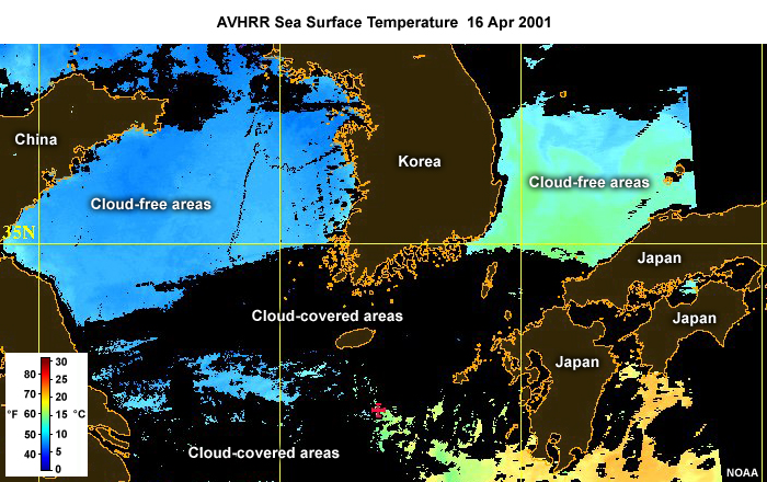
Description:
AVHRR sea surface temperature product highlighting cloud-free and cloud-covered areas across the East China Sea region on April 16, 2001.
File Name:
avhrr_2_6_cloud_and_cloudfree.jpg
Credits:
NOAA
Copyright Terms:
COMET Standard Terms
of Use
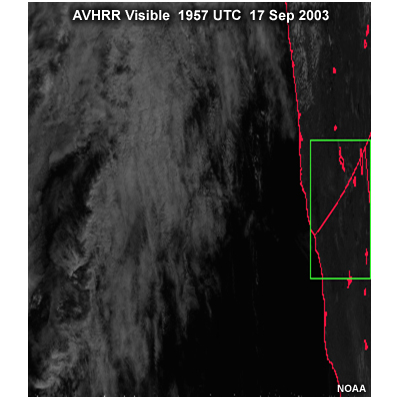
Description:
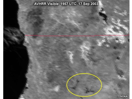
AVHRR visible image over the western United States with box highlighting an edge-of-scan area; taken at 1957 UTC on September 17, 2003.
File Name:
avhrr_4_1.jpg
Credits:
NOAA
Copyright Terms:
COMET Standard Terms
of Use
Description:
AVHRR visible image over the United States Pacific Northwest highlighting the degraded resolution seen near the edge-of-scan; taken at 1957 UTC on September 17, 2003.
File Name:
avhrr_4_2.jpg
Credits:
NOAA
Copyright Terms:
COMET Standard Terms
of Use
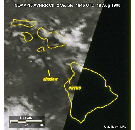
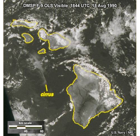
Description:
NOAA-10 AVHRR channel 2 visible image taken over the Hawaiian Islands showing degraded spatial resolution near the edge of the image swath.
File Name:
avhrr_4_4.jpg
Credits:
U.S. Navy / NRL
Copyright Terms:
COMET Standard Terms
of Use
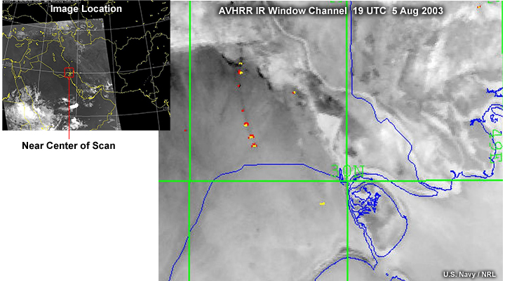
Description:
NOAA AVHRR longwave infrared window channel image taken near the center of the scan, near nadir view, showing gas flares (hot spots) from oil wells over southeastern Iraq, near nadir viewing, at 19 UTC on August 5, 2003.
File Name:
avhrr_4_5_1.jpg
Credits:
U.S. Navy / NRL (both images)
Copyright Terms:
COMET Standard Terms
of Use
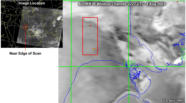
Description:
NOAA AVHRR longwave infrared window channel image taken near the edge of the scan, highlighting gas flares (hot spots) from oil wells over southeastern Iraq at 19 UTC on August 5, 2003.
File Name:
avhrr_4_5_2.jpg
Credits:
U.S. Navy / NRL (both images)
Copyright Terms:
COMET Standard Terms
of Use
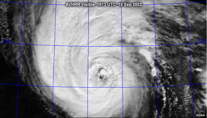
Description:
NOAA AVHRR visible image of hurricane Isabel off the U.S. east coast taken at 1613 UTC on September 18, 2002.
File Name:
avhrr_5_5.jpg
Credits:
NOAA
Copyright Terms:
COMET Standard Terms
of Use
Description:
Table summarizing AVHRR contributions to VIIRS spectral coverage, spatial resolution, and products.
File Name:
avhrr_to_viirs_2_4.gif
Credits:
©The COMET Program
Copyright Terms:
COMET Standard Terms
of Use
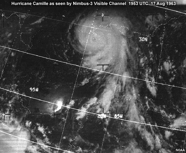
Description:
A visible image of hurricane Camille as seen by the Nimbus-3 polar-orbiting satellite at 1953 UTC on August 17, 1969.
File Name:
camille_vis.jpg
Credits:
NOAA
Copyright Terms:
COMET Standard Terms
of Use
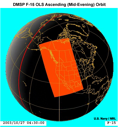
Description:
Illustration showing an evening DMSP orbit and ground coverage for the OLS imager over Southern California at 4:30 UTC (21:30 mid-evening local time) on October 27, 2003.
File Name:
dmsp_f15_orbit_1_3.jpg
Credits:
U.S. Navy / NRL
Copyright Terms:
COMET Standard Terms
of Use

Description:
Illustration of the DMSP polar-orbiting satellite in orbit.
File Name:
dmsp_lo_250.jpg
Credits:
U.S. Air Force
Copyright Terms:
COMET Standard Terms
of Use
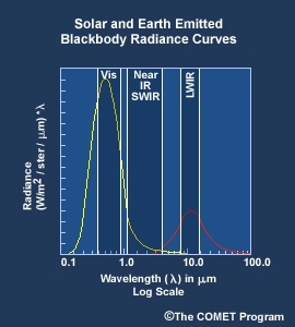
Description:
Plot showing solar and Earth emitted enery spectra as blackbody radiance curves, with visible, near infrared, shortwave infrared, and longwave infrared regions highlighted.
File Name:
em_spec_sm_prnt270.jpg
Credits:
©The COMET Program
Copyright Terms:
COMET Standard Terms
of Use
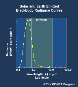
Description:
Electromagnetic spectrum with solar and thermal blackbody curves highlighting the solar and thermal portions of the spectrum.
File Name:
em_spec_sm270.jpg
Credits:
©The COMET Program
Copyright Terms:
COMET Standard Terms
of Use
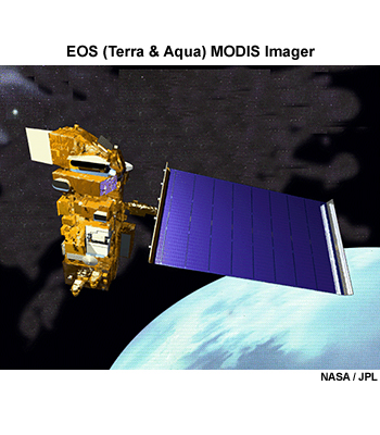
Description:
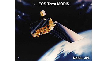
Illustration of the EOS Terra satellite orbiting Earth; carries the MODIS imager.
File Name:
eos_terra.jpg
Credits:
NASA / JPL
Copyright Terms:
COMET Standard Terms
of Use
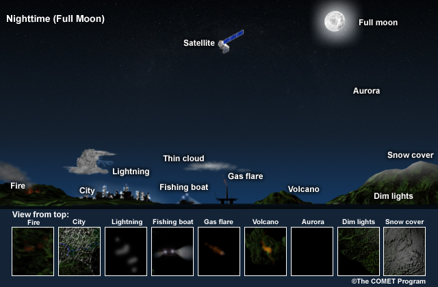
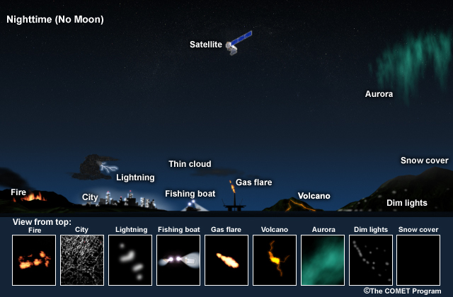
Description:
Conceptual drawing of several land, ocean and cloud features at night that are detectable during a full moon.
File Name:
full_moon_satellite.jpg
Credits:
©The COMET Program
Copyright Terms:
COMET Standard Terms
of Use
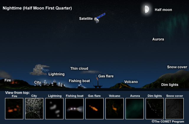
Description:
Conceptual drawing of several land, ocean and cloud features at night that are detectable during a first quarter, half moon.
File Name:
half_moon_first_quarter_satellite.jpg
Credits:
©The COMET Program
Copyright Terms:
COMET Standard Terms
of Use

Description:
Hurricane Isabel with GOES-12 visible imagery starting at 1246 UTC on September 18, 2003.
File Name:
isabel_goes_ani.jpg
Credits:
NOAA
Copyright Terms:
COMET Standard Terms
of Use

Description:
Animation showing hurricane Isabel with GOES-12 visible imagery from 1246 to 1745 UTC on September 18, 2003.
File Name:
isabel_goes_ani.mp4
Credits:
NOAA
Copyright Terms:
COMET Standard Terms
of Use
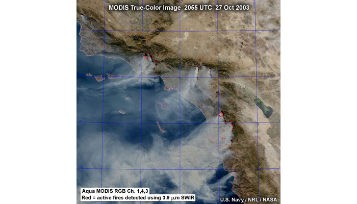
Description:
EOS-Terra MODIS true-color image with active fires overlay showing fires over Southern California and northwestern Mexico at 2055 UTC on October 27, 2003.
File Name:
modis_1_5.jpg
Credits:
U.S. Navy / NRL / NASA
Copyright Terms:
COMET Standard Terms
of Use
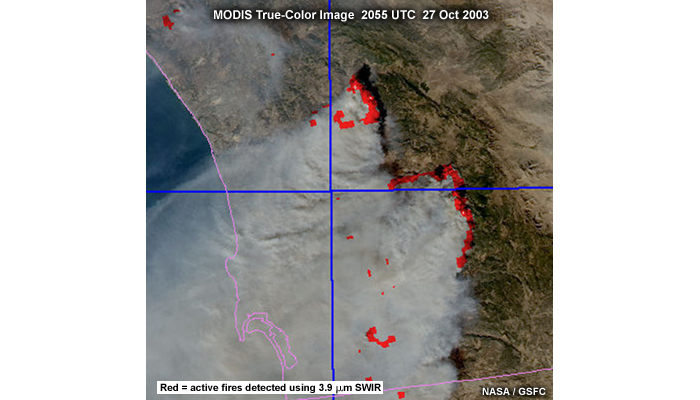
Description:
Zoomed in EOS-Terra MODIS true-color image with active fires overlay showing fires over Southern California at 2055 UTC on October 27, 2003.
File Name:
modis_1_6.jpg
Credits:
NASA / GSFC
Copyright Terms:
COMET Standard Terms
of Use
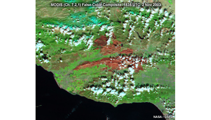
Description:
EOS-Terra MODIS false-color image of burn scars left by fires over Southern California taken at 1835 UTC on November 2, 2003.
File Name:
modis_1_7.jpg
Credits:
NASA / GSFC
Copyright Terms:
COMET Standard Terms
of Use

Description:
A false-color dust product image produced from the EOS-Aqua MODIS imager over the Arabian Gulf region on March 27, 2002.
File Name:
modis_3_5.jpg
Credits:
U.S. Navy / NRL / FNMOC / NASA
Copyright Terms:
COMET Standard Terms
of Use
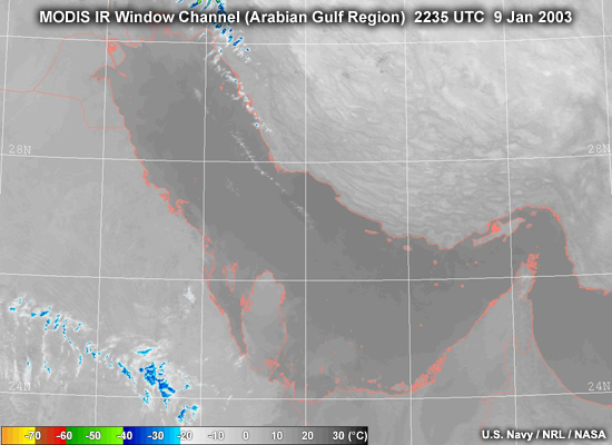
Description:
A nighttime MODIS infrared window channel image over the Arabian Gulf taken at 2235 UTC on January 9, 2003.
File Name:
modis_5_10_ir.jpg
Credits:
U.S. Navy / NRL / NOAA
Copyright Terms:
COMET Standard Terms
of Use

Description:
A nighttime MODIS fog and low cloud false-color composite image over the Arabian Gulf taken at 2235 UTC on January 9, 2003.
File Name:
modis_5_10_lowcld.jpg
Credits:
U.S. Navy / NRL / NASA
Copyright Terms:
COMET Standard Terms
of Use
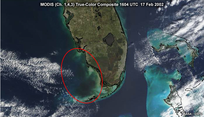
Description:
MODIS true-color composite image over southern Florida and coastal regions highlighting water conditions during an algal bloom event, taken at 1604 UTC on February 17, 2002.
File Name:
modis_5_11_feb.jpg
Credits:
NASA / GSFC
Copyright Terms:
COMET Standard Terms
of Use
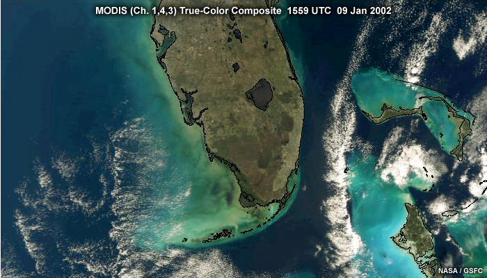
Description:
MODIS true-color composite image over southern Florida and coastal regions showing water conditions during the start of a “red tide” or algal bloom event, taken at 1559 UTC on January 9, 2002.
File Name:
modis_5_11_jan.jpg
Credits:
NASA / GSFC
Copyright Terms:
COMET Standard Terms
of Use
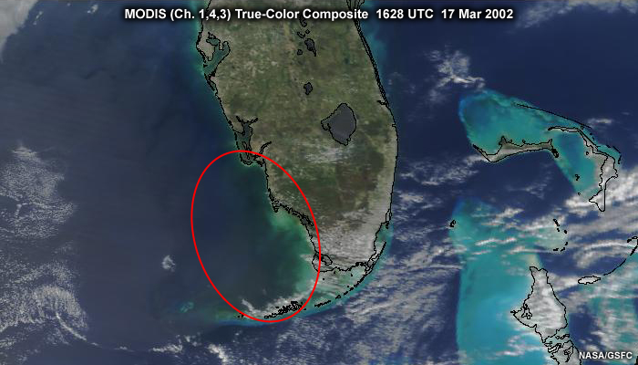
Description:
MODIS true-color composite image over southern Florida and coastal regions showing water returning to more normal conditions after an algal bloom event, taken at 1628 UTC on March 17, 2002.
File Name:
modis_5_11_mar.jpg
Credits:
NASA / GSFC
Copyright Terms:
COMET Standard Terms
of Use
Description:
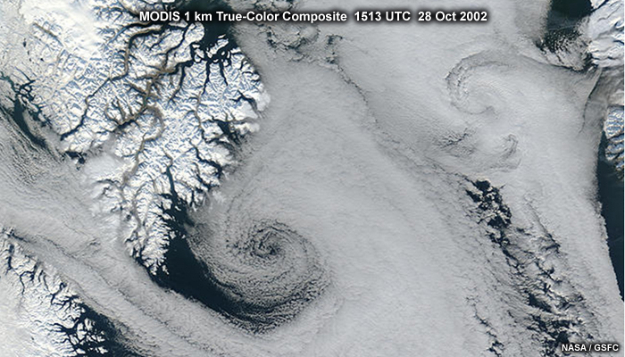
MODIS true-color composite image showing a polar low over the Davis Straight between Nunavut Canada and Greenland, taken at 1513 UTC on October 28, 2002.
File Name:
modis_5_3.jpg
Credits:
NASA / GSFC
Copyright Terms:
COMET Standard Terms
of Use
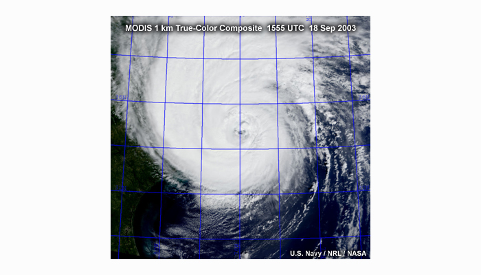
Description:
Terra MODIS 1 km resolution true-color composite image of hurricane Isabel off the U.S. east coast taken at 1555 UTC on September 18, 2003.
File Name:
modis_5_6_1.jpg
Credits:
U.S. Navy / NRL / NASA
Copyright Terms:
COMET Standard Terms
of Use
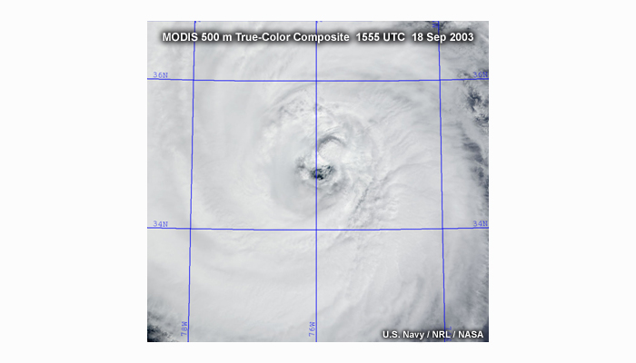
Description:
Terra MODIS 500 m resolution true-color composite image of hurricane Isabel off the U.S. east coast taken at 1555 UTC on September 18, 2003.
File Name:
modis_5_6_2.jpg
Credits:
U.S. Navy / NRL / NASA
Copyright Terms:
COMET Standard Terms
of Use
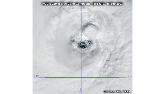
Description:
Terra MODIS 250 m resolution true-color composite image of hurricane Isabel off the U.S. east coast taken at 1555 UTC on September 18, 2003.
File Name:
modis_5_6_3.jpg
Credits:
U.S. Navy / NRL / NASA
Copyright Terms:
COMET Standard Terms
of Use
Description:
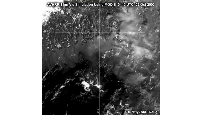
Simulated AVHRR visible using MODIS 1 km image of the Bangladesh coastline taken at 0440 UTC on October 2, 2003.
File Name:
modis_5_7_1.jpg
Credits:
U.S. Navy / NRL / NASA
Copyright Terms:
COMET Standard Terms
of Use
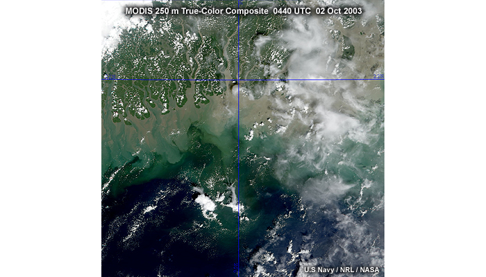
Description:
MODIS 250 m resolution true-color composite image of the Bangladesh coastline taken at 0440 UTC on October 2, 2003.
File Name:
modis_5_7_1_tc.jpg
Credits:
U.S. Navy / NRL / NASA
Copyright Terms:
COMET Standard Terms
of Use
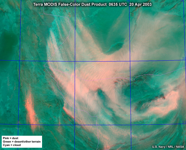
Description:
A MODIS false-color dust enhancement product image showing blowing dust over western Afghanistan at 0635 UTC on April 20, 2003.
File Name:
modis_dust_example.jpg
Credits:
U.S. Navy / NRL / NASA
Copyright Terms:
COMET Standard Terms
of Use

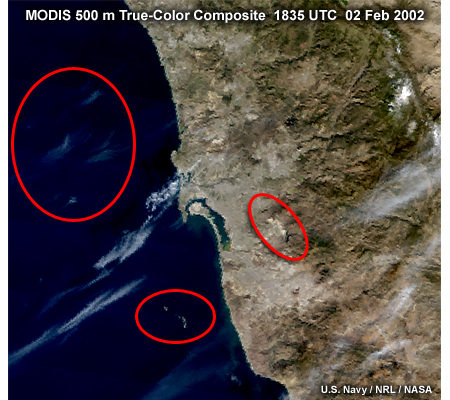
Description:
MODIS 1 km true-color composite image over the San Diego, California coastal region highlighting thin cirrus, islands, and reservoirs, taken at 1835 UTC on February 2, 2002.
File Name:
modis_sd_5_8_1_outlines.jpg
Credits:
U.S. Navy / NRL / NASA
Copyright Terms:
COMET Standard Terms
of Use
Description:
MODIS 500 meter true-color composite image over the San Diego, California coastal region highlighting thin cirrus, islands, and reservoirs, taken at 1835 UTC on February 2, 2002.
File Name:
modis_sd_5_8_2_outlines.jpg
Credits:
U.S. Navy / NRL / NASA
Copyright Terms:
COMET Standard Terms
of Use
Description:
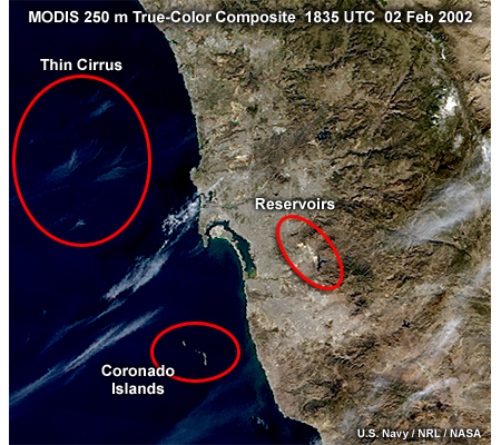
MODIS 250 meter true-color composite image over the San Diego, California coastal region highlighting thin cirrus, islands, and reservoirs, taken at 1835 UTC on February 2, 2002.
File Name:
modis_sd_5_8_3_outlines.jpg
Credits:
U.S. Navy / NRL / NASA
Copyright Terms:
COMET Standard Terms
of Use
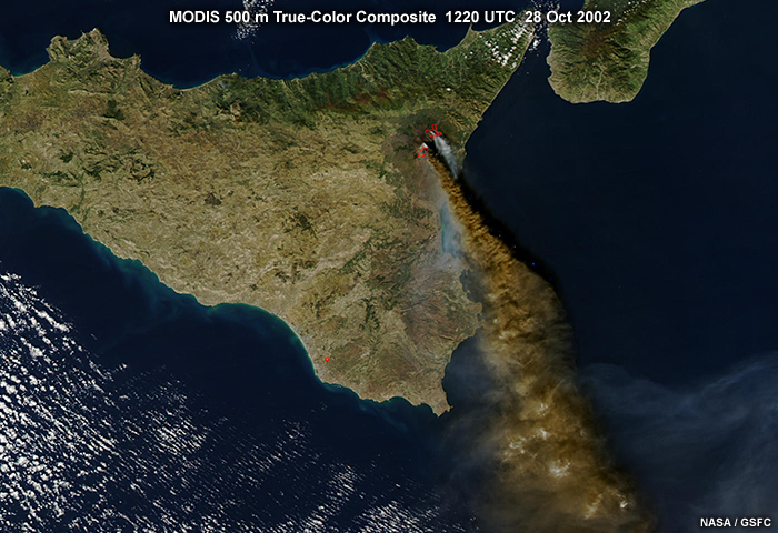
Description:
MODIS 500 meter resolution true-color image of Mt. Etna volcanic eruption on the island of Sicily taken at 1220 UTC on October 28, 2002.
File Name:
modis_va_5_9_1.jpg
Credits:
NASA / GSFC
Copyright Terms:
COMET Standard Terms
of Use

Description:
Aqua MODIS true-color image of Mt. Etna volcanic eruption on the island of Sicily taken at 1220 UTC on October 28, 2002.
File Name:
modis_va_5_9_2.jpg
Credits:
NASA / GSFC
Copyright Terms:
COMET Standard Terms
of Use

Description:
Animation showing various polar-orbiting meteorological satellites in orbit and ground coverage for each satellite's respective imager instrument.
File Name:
multiple_poes_1_2.mp4
Credits:
U.S. Navy / NRL
Copyright Terms:
COMET Standard Terms
of Use
Description:
Conceptual drawing showing appearance of several land, ocean and cloud features at night with no illumination by moonlight.
File Name:
no_moon_satellite.jpg
Credits:
©The COMET Program
Copyright Terms:
COMET Standard Terms
of Use

Description:
Illustration of the NOAA polar-orbiting satellite in orbit.
File Name:
noaa_lo_250.jpg
Credits:
NASA
Copyright Terms:
COMET Standard Terms
of Use
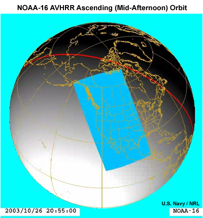
Description:
Illustration showing an ascending orbit and ground coverage for NOAA-16 AVHRR over Southern California during mid-afternoon local time at 2055 UTC on October 26, 2003.
File Name:
noaa_orbit_1_4.jpg
Credits:
U.S. Navy / NRL
Copyright Terms:
COMET Standard Terms
of Use
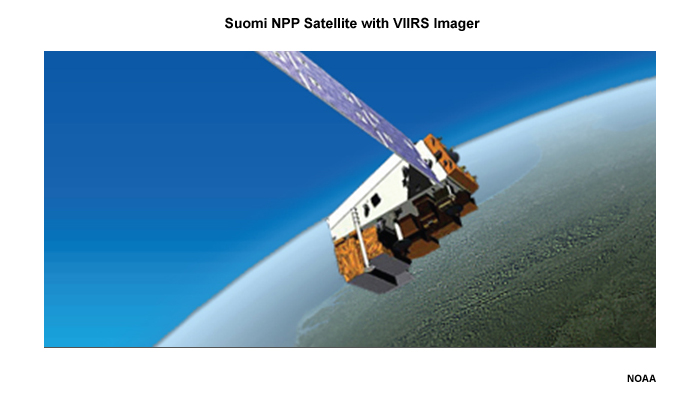
Description:
Artist's rendition of the Suomi NPP (National Polar-orbiting Partnership) spacecraft.
File Name:
npp_spacecraft.jpg
Credits:
NOAA
Copyright Terms:
COMET Standard Terms
of Use
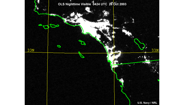
Description:
DMSP OLS nighttime visible image of fires and lights over regions of Southern California and northwestern Mexico taken at 04:24 UTC on October 26, 2003.
File Name:
ols_1_2_a.jpg
Credits:
U.S. Navy / NRL
Copyright Terms:
COMET Standard Terms
of Use
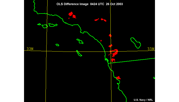
Description:
DMSP OLS difference image highlighting fires over regions of Southern California and northwestern Mexico taken at 04:24 UTC on 26 October 2003.
File Name:
ols_1_2_b.jpg
Credits:
U.S. Navy / NRL
Copyright Terms:
COMET Standard Terms
of Use
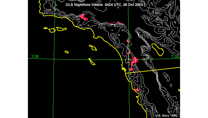
Description:
DMSP OLS difference image showing fires with a topography contour overlay over regions of Southern California and northwestern Mexico taken at 04:24 UTC on October 26, 2003.
File Name:
ols_1_2_c.jpg
Credits:
U.S. Navy / NRL
Copyright Terms:
COMET Standard Terms
of Use
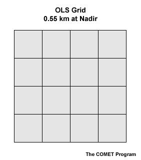
Description:
DMSP OLS imaging channel grid, 0.55 km at nadir viewing angles.
File Name:
ols_2_3.gif
Credits:
©The COMET Program
Copyright Terms:
COMET Standard Terms
of Use
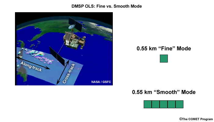
Description:
DMSP OLS imager along-track and cross-track scanning; fine vs. smooth mode pixel resolutions; smooth mode pixels are shown on the right before averaging in the cross-track direction.
File Name:
ols_3_1_a.jpg
Credits:
NASA/GSFC (satellite swath pic upper left) ©The COMET Program (lower right)
Copyright Terms:
COMET Standard Terms
of Use
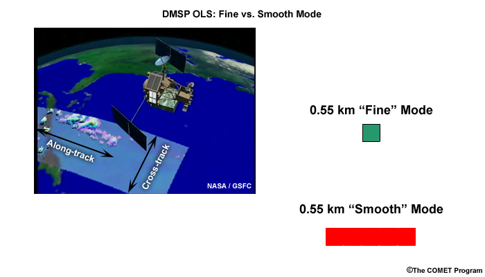
Description:
DMSP OLS imager along-track and cross-track scanning; fine vs. smooth mode pixel resolutions; smooth mode is shown on the right after five pixel averaging in the cross-track direction.
File Name:
ols_3_1_b.jpg
Credits:
NASA/GSFC (satellite swath pic upper left) ©The COMET Program (lower right)
Copyright Terms:
COMET Standard Terms
of Use
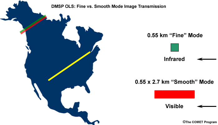
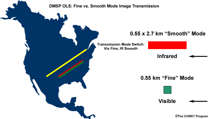
Description:
Illustration showing DMSP OLS fine vs. smooth image transition modes.
File Name:
ols_3_2_a.jpg
Credits:
©The COMET Program
Copyright Terms:
COMET Standard Terms
of Use
Description:
Illustration showing DMSP OLS fine vs. smooth image transition modes.
File Name:
ols_3_2_b.jpg
Credits:
©The COMET Program
Copyright Terms:
COMET Standard Terms
of Use
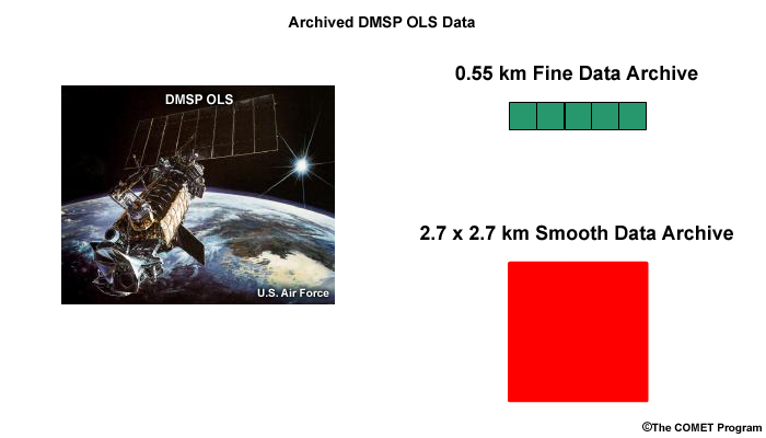
Description:
Illustration showing DMSP OLS data resolution in the NOAA NGDC archive.
File Name:
ols_3_2a_archive.jpg
Credits:
U.S. Air Force (upper left inset) ©The COMET Program (lower right)
Copyright Terms:
COMET Standard Terms
of Use
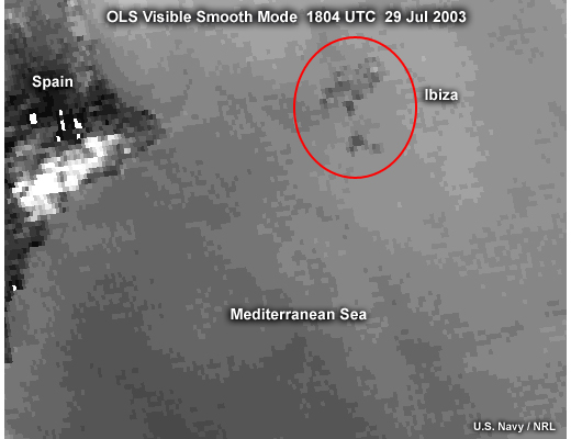
Description:
DMSP OLS smooth mode visible image along the east coast of Spain highlighting the coarse resolution and difficulty in seeing fine scale features; taken at 1804 (early evening) on July 29, 2003.
File Name:
ols_3_3_1.jpg
Credits:
U.S. Navy / NRL
Copyright Terms:
COMET Standard Terms
of Use
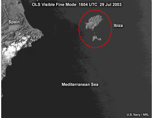
Description:
DMSP OLS fine mode visible image along the east coast of Spain highlighting the improved pixel resolution but lesser bit depth compared to smooth mode visible imagery; taken at 1804 (early evening) on July 29, 2003.
File Name:
ols_3_3_2.jpg
Credits:
U.S. Navy / NRL
Copyright Terms:
COMET Standard Terms
of Use
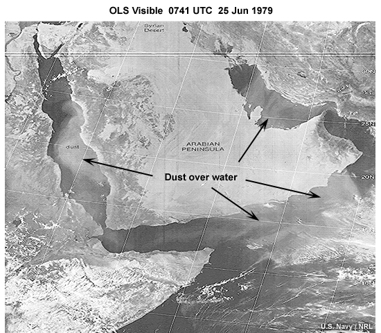
Description:
DMSP OLS daytime visible image highlighting dust over water around the Arabian Peninsula taken by DMSP at 0741 UTC on June 25, 1979.
File Name:
ols_3_4_1.jpg
Credits:
U.S. Navy / NRL
Copyright Terms:
COMET Standard Terms
of Use
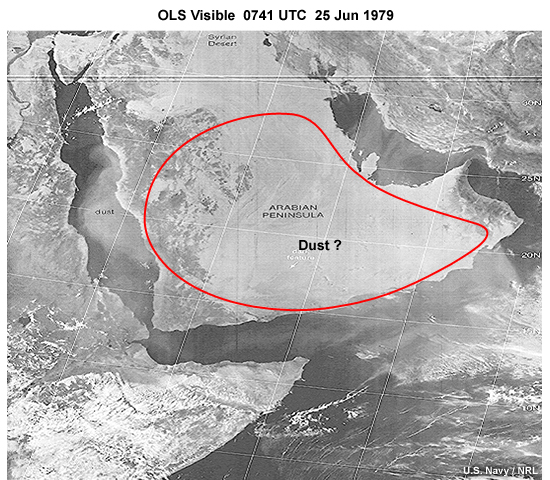
Description:
DMSP OLS daytime visible image highlighting dust over water and land in the region of the Arabian Peninsula taken by DMSP at 0741 UTC on June 25, 1979.
File Name:
ols_3_4_2.jpg
Credits:
U.S. Navy / NRL
Copyright Terms:
COMET Standard Terms
of Use
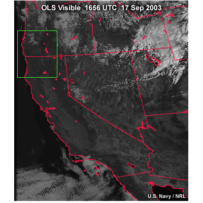
Description:
OLS fine mode visible image over the western United States with box highlighting an edge-of-scan area; taken at 1656 UTC on September 17, 2003.
File Name:
ols_4_1.jpg
Credits:
U.S. Navy / NRL
Copyright Terms:
COMET Standard Terms
of Use
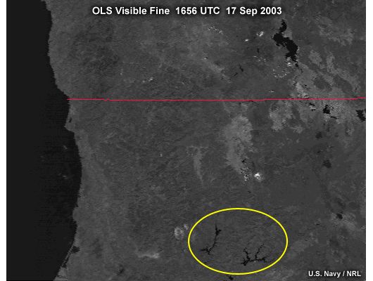
Description:
OLS fine mode visible image over the United States Pacific Northwest highlighting the relatively high resolution maintained near the edge-of-scan; taken at 1656 UTC on September 17, 2003.
File Name:
ols_4_2.jpg
Credits:
U.S. Navy / NRL
Copyright Terms:
COMET Standard Terms
of Use
Description:
DMSP F-9 OLS visible image taken over the Hawaiian Islands showing preservation of relatively high spatial resolution near the edge of the image swath due to the imager's unique scanning abilities.
File Name:
ols_4_4.jpg
Credits:
U.S. Navy / NRL
Copyright Terms:
COMET Standard Terms
of Use
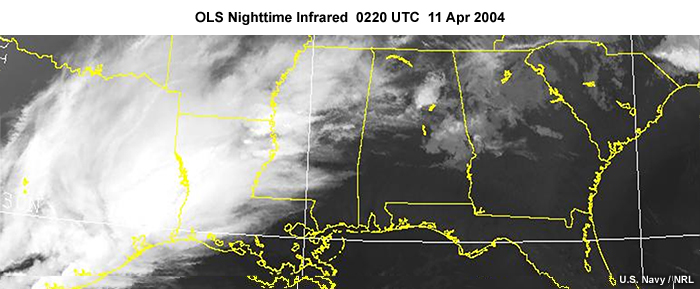
Description:
DMSP OLS nighttime infrared image over the southern U.S. showing cloud cover and clear sky condidtions at 0220 UTC on April 11, 2004.
File Name:
ols_6_10_ir.jpg
Credits:
U.S. Navy / NRL
Copyright Terms:
COMET Standard Terms
of Use
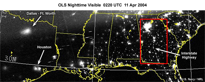
Description:
DMSP OLS nighttime visible image over the southern U.S. showing city lights at night at 0220 UTC on April 11, 2004.
File Name:
ols_6_10_nv.jpg
Credits:
U.S. Navy / NRL
Copyright Terms:
COMET Standard Terms
of Use
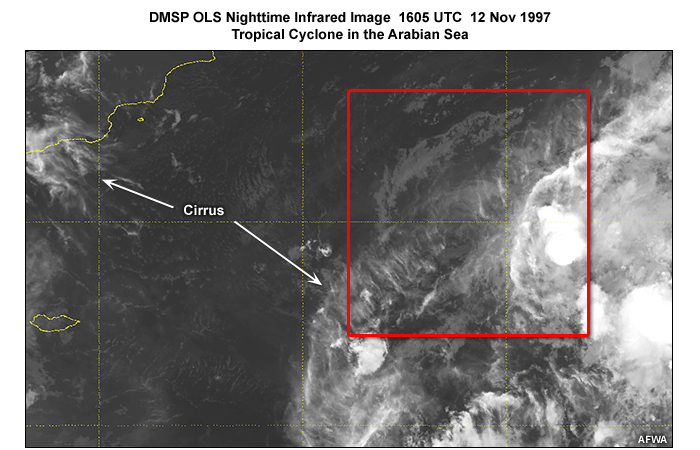
Description:
DMSP OLS nighttime infrared image over the Arabian Sea, unable to detect tropical cyclone circulation features due to lack of thermal contrast between low level clouds and water surface; taken at 1605 UTC (local evening) on November 12, 1997.
File Name:
ols_6_12_ir.jpg
Credits:
AFWA
Copyright Terms:
COMET Standard Terms
of Use
Description:
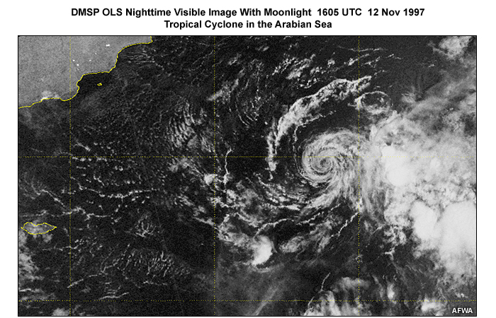
DMSP OLS nighttime visible image over the Arabian sea showing the low level circulation of a tropical cyclone illuminated by moonlight conditions; taken at 1605 UTC (local evening) on November 12, 1997.
File Name:
ols_6_12_nv.jpg
Credits:
AFWA
Copyright Terms:
COMET Standard Terms
of Use
Description:
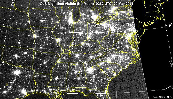
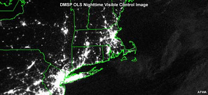
DMSP OLS nighttime visible image over the central and eastern U.S. during no moon conditions showing cities and other artificial light sources at night; taken at 0252 UTC on March 20, 2004.
File Name:
ols_6_5.jpg
Credits:
U.S. Navy / NRL
Copyright Terms:
COMET Standard Terms
of Use
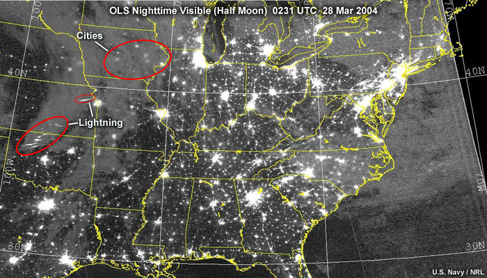
Description:
DMSP OLS nighttime visible image over the central and eastern U.S. during half moon conditions showing cities, cities through cloud cover, lightning, and dimly lit clouds and cloud boundaries at night; taken at 0231 UTC on March 28, 2004.
File Name:
ols_6_6.jpg
Credits:
U.S. Navy / NRL
Copyright Terms:
COMET Standard Terms
of Use
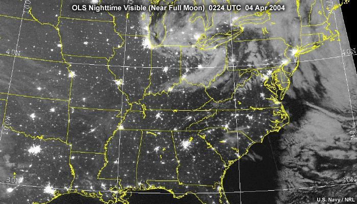
Description:
DMSP OLS nighttime visible image over the central and eastern U.S. during full moon conditions showing cloud cover and cities at night; taken at 0224 UTC on April 4, 2004.
File Name:
ols_6_7.jpg
Credits:
U.S. Navy / NRL
Copyright Terms:
COMET Standard Terms
of Use
Description:
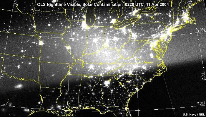
DMSP OLS nighttime visible image over the central and eastern U.S. during three-quarter moon conditions showing solar glare as direct sunlight enters the OLS instrument; taken during night at 0220 UTC on April 11, 2004.
File Name:
ols_6_7a.jpg
Credits:
U.S. Navy / NRL
Copyright Terms:
COMET Standard Terms
of Use

Description:
DMSP OLS nighttime visible image showing an aurora borealis (northern lights) event over North America.
File Name:
ols_6_8_1.jpg
Credits:
U.S. Navy / NRL
Copyright Terms:
COMET Standard Terms
of Use
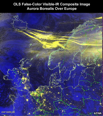
Description:
DMSP OLS nighttime visible and infrared composite image showing an aurora borealis (northern lights) event over Europe.
File Name:
ols_6_8_2.jpg
Credits:
AFWA
Copyright Terms:
COMET Standard Terms
of Use
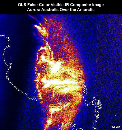
Description:
DMSP OLS nighttime visible and infrared composite image showing an aurora australis (southern lights) over the Antarctic.
File Name:
ols_6_8_3.jpg
Credits:
AFWA
Copyright Terms:
COMET Standard Terms
of Use
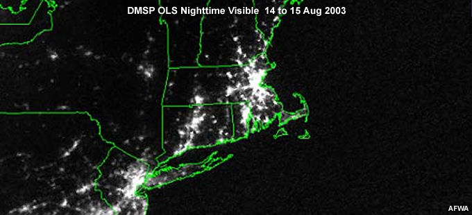
Description:
DMSP OLS nighttime visible image showing cities in the northeastern U.S. during an electrical blackout affecting large portions of the area on 14 to 15 August, 2003.
File Name:
ols_6_9_1.jpg
Credits:
AFWA
Copyright Terms:
COMET Standard Terms
of Use
Description:
DMSP OLS nighttime visible image showing cities in the northeastern U.S. during normal electrical power conditions.
File Name:
ols_6_9_2.jpg
Credits:
AFWA
Copyright Terms:
COMET Standard Terms
of Use
Description:
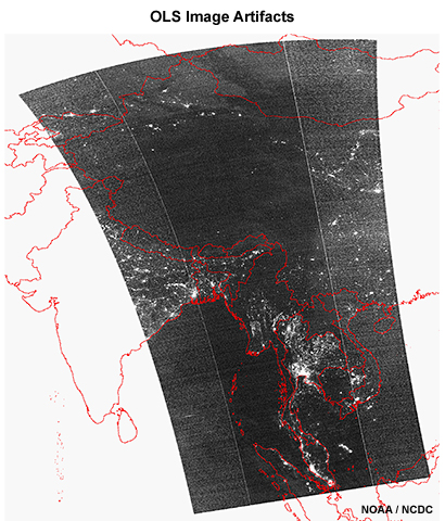
DMSP OLS nighttime visible image showing artifacts, vertical lines, in the image resulting from the processing of observations into imagery.
File Name:
ols_artifacts_6_9_1.jpg
Credits:
NOAA / NCDC
Copyright Terms:
COMET Standard Terms
of Use
Description:
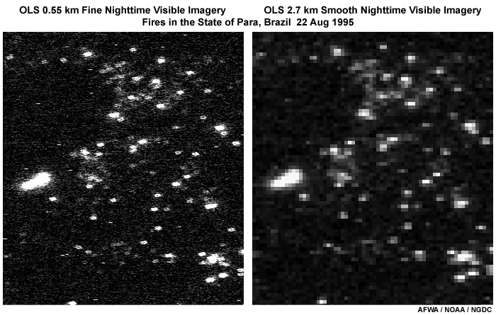
DMSP OLS fine vs. smooth mode nighttime visible images taken of fires over the state of Para in Brazil on August 22, 1995.
File Name:
ols_fine_vs_smooth.jpg
Credits:
AFWA / NOAA / NGDC
Copyright Terms:
COMET Standard Terms
of Use

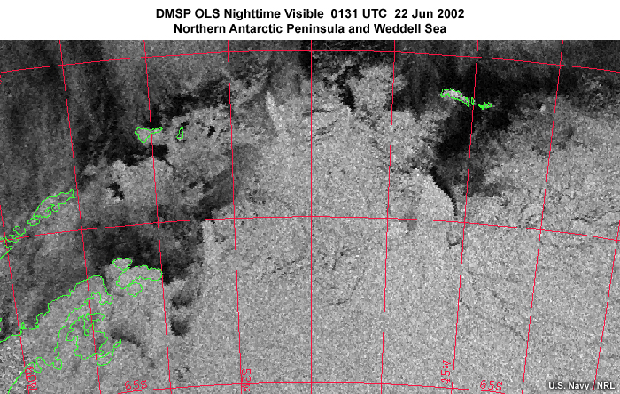
Description:
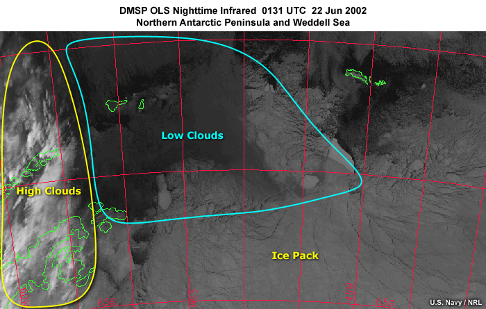
DMSP OLS nighttime fine mode infrared image over the northern most Antarctic Peninsula, islands, and adjacent Weddell Sea showing land, ocean, and polar ice pack at 0131 UTC on June 22, 2002.
File Name:
ols_ir_6_10_1.jpg
Credits:
U.S. Navy / NRL
Copyright Terms:
COMET Standard Terms
of Use
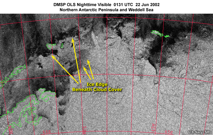
Description:
DMSP OLS nighttime fine mode infrared image over the northern most Antarctic Peninsula, islands, and adjacent Weddell Sea highlighting ice pack, and low and high cloud cover at 0131 UTC on June 22, 2002.
File Name:
ols_ir_6_10_1b.jpg
Credits:
U.S. Navy / NRL
Copyright Terms:
COMET Standard Terms
of Use
Description:
DMSP OLS nighttime visible image taken during new moon conditions.
File Name:
ols_nv_6_13.jpg
Credits:
NOAA / NCDC
Copyright Terms:
COMET Standard Terms
of Use
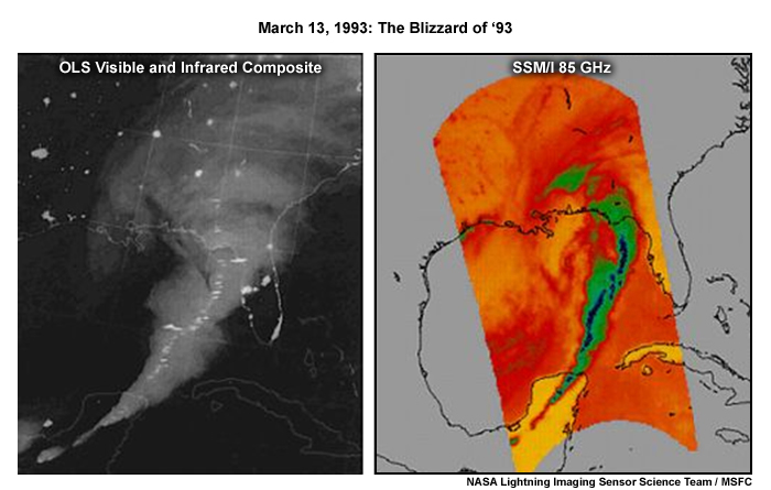
Description:
A DMSP OLS nighttime visible-infrared composite image (left) and SSM/I 85 GHz channel image (right) over the southeastern U.S. showing the blizzard of 1993, and highlighting a squall line with embedded lightning and heavy rainfall at night on March 13, 1993.
File Name:
ols_s6p6a.jpg
Credits:
NASA Lightning Imaging Sensor Science Team / MSFC
Copyright Terms:
COMET Standard Terms
of Use
Description:
DMSP OLS nighttime smooth mode visible image over the northern most Antarctic Peninsula, islands, and adjacent Weddell Sea showing land, ocean, and polar ice pack at 0131 UTC on June 22, 2002.
File Name:
ols_vis_6_10_2.jpg
Credits:
U.S. Navy / NRL
Copyright Terms:
COMET Standard Terms
of Use
Description:
DMSP OLS nighttime smooth mode visible image over the northern most Antarctic Peninsula, islands, and adjacent Weddell Sea highlighting edges of the polar ice pack at 0131 UTC on June 22, 2002.
File Name:
ols_vis_6_10_2b.jpg
Credits:
U.S. Navy / NRL
Copyright Terms:
COMET Standard Terms
of Use
Description:
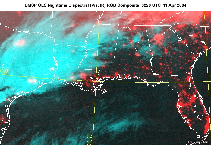
DMSP OLS nighttime bispectral visible and infrared RGB composite image over the southern U.S. highlighting cloud cover (from the infrared channel) and city lights (from the visible channel) at 0220 UTC on April 11, 2004.
File Name:
ols_visir_comp_6_11.jpg
Credits:
U.S. Navy / NRL
Copyright Terms:
COMET Standard Terms
of Use
Description:
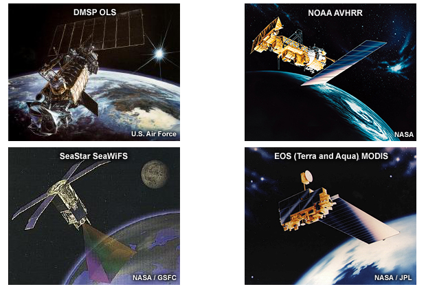
Four illustrations of polar-orbiting satellite imagers that contributed to the development of the VIIRS imager: DMSP OLS, NOAA AVHRR, Seastar SeaWiFS, EOS-Terra and -Aqua MODIS.
File Name:
s1p1sc2.jpg
Credits:
U.S. Air Force, NASA, NASA/GSFC, NASA/JPL
Copyright Terms:
COMET Standard Terms
of Use
Description:
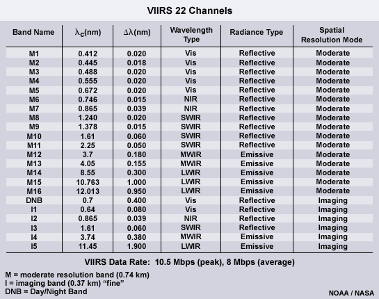
Table summarizing the VIIRS 22 channels and their spectral characteristics.
File Name:
s1p1sc4.gif
Credits:
NOAA / NASA
Copyright Terms:
COMET Standard Terms
of Use

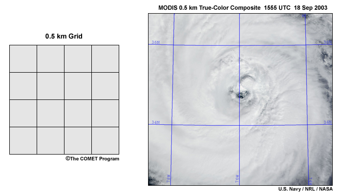
Description:
1 km grid (left) and MODIS 1 km true-color image (right) of Hurricane Isabel at 1555 UTC on September 18, 2003.
File Name:
s2p1_1p.jpg
Credits:
©The COMET Program (left) U.S. Navy / NRL / NASA (right)
Copyright Terms:
COMET Standard Terms
of Use
Description:
0.5 km grid (left) and MODIS 0.5 km true-color image (right) of Hurricane Isabel at 1555 UTC on September 18, 2003
File Name:
s2p1_2p.jpg
Credits:
©The COMET Program (left) U.S. Navy / NRL / NASA (right)
Copyright Terms:
COMET Standard Terms
of Use
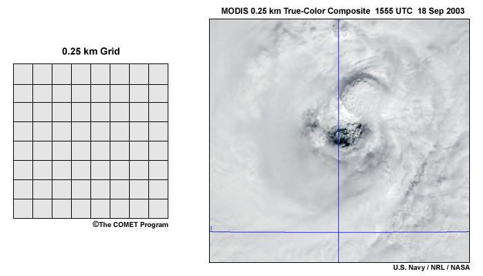
Description:
0.25 km grid (left) and MODIS 0.25 km true-color image (right) of Hurricane Isabel at 1555 UTC on September 18, 2003
File Name:
s2p1_3p.jpg
Credits:
©The COMET Program (left) U.S. Navy / NRL / NASA (right)
Copyright Terms:
COMET Standard Terms
of Use
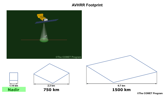
Description:
Illustration of changing AVHRR pixel geometry as the imager scans from nadir view toward the scan edge; nadir pixel view is highlighted.
File Name:
s4p3_1.gif
Credits:
©The COMET Program (both upper right inset and lower left corner)
Copyright Terms:
COMET Standard Terms
of Use

Description:
Illustration of changing AVHRR pixel geometry as the imager scans from nadir view toward the scan edge; pixel at position half-way between nadir and edge of the scan is highlighted.
File Name:
s4p3_2.gif
Credits:
©The COMET Program (both upper right inset and lower left corner)
Copyright Terms:
COMET Standard Terms
of Use
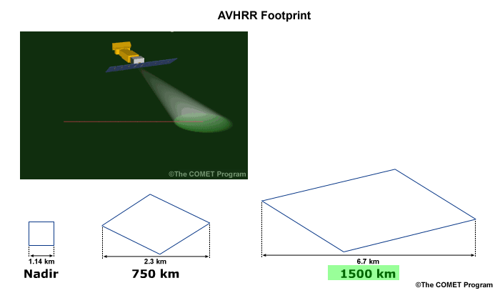
Description:
Illustration of changing AVHRR pixel geometry as the imager scans from nadir view toward scan edge; pixel at position near the edge of the scan is highlighted.
File Name:
s4p3_3.gif
Credits:
©The COMET Program (both upper right inset and lower left corner)
Copyright Terms:
COMET Standard Terms
of Use

Description:
Illustration of changing OLS pixel geometry as the imager scans from nadir toward scan edge.
File Name:
s4p3_4.jpg
Credits:
©The COMET Program
Copyright Terms:
COMET Standard Terms
of Use
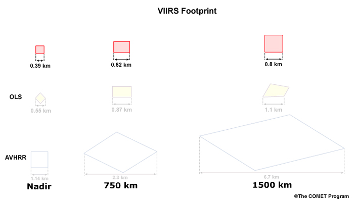
Description:
Illustration of changing VIIRS pixel geometry for the high resolution channels as the imager scans from nadir toward scan edge.
File Name:
s4p3_5.jpg
Credits:
©The COMET Program
Copyright Terms:
COMET Standard Terms
of Use
Description:
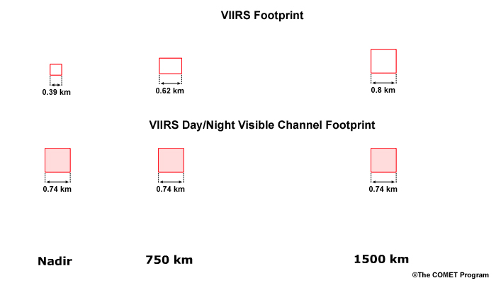
Illustration comparing VIIRS pixel geometry for the high resolution channels as the imager scans from nadir toward scan edge, and the constant pixel geometry for the day/night visible channel.
File Name:
s4p3_6.jpg
Credits:
©The COMET Program
Copyright Terms:
COMET Standard Terms
of Use
Description:
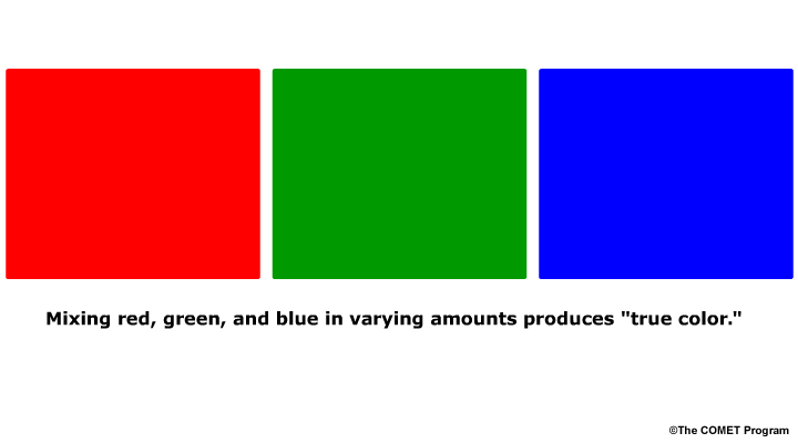
Illustration showing the three primary colors of the RGB color model used for making true color imagery.
File Name:
s5p2_1.gif
Credits:
©The COMET Program
Copyright Terms:
COMET Standard Terms
of Use

Description:
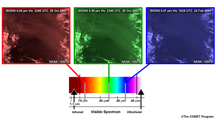
Illustration showing three separate MODIS visible channels, each representing a different portion of the visible spectrum and how each appears in black and white.
File Name:
s5p2_2.jpg
Credits:
©The COMET Program
Copyright Terms:
COMET Standard Terms
of Use
Description:
Illustration showing how each one of three separate MODIS visible channels represents input to the primary colors, red, green, and blue.
File Name:
s5p2_3.jpg
Credits:
©The COMET Program
Copyright Terms:
COMET Standard Terms
of Use
Description:
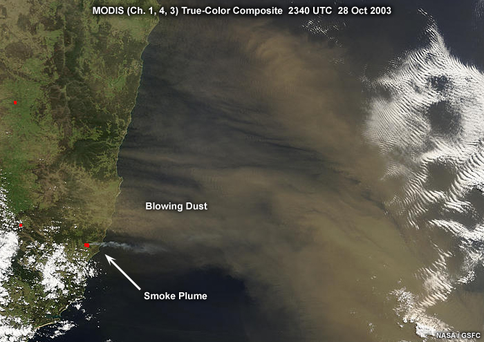
MODIS true-color composite image showing blowing dust and smoke plume along the coast of southeastern Australia, taken at 2340 UTC on October 28, 2003.
File Name:
s5p2_au.jpg
Credits:
NASA / GSFC
Copyright Terms:
COMET Standard Terms
of Use
Description:
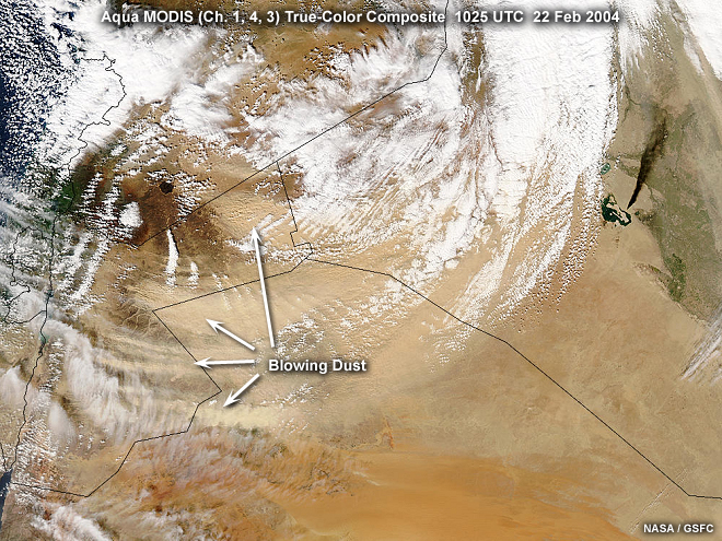
Aqua MODIS true-color composite image showing blowing dust and cloud cover over portions of the Middle East, taken at 1025 UTC on February 22, 2004.
File Name:
s5p2_me.jpg
Credits:
NASA / GSFC
Copyright Terms:
COMET Standard Terms
of Use
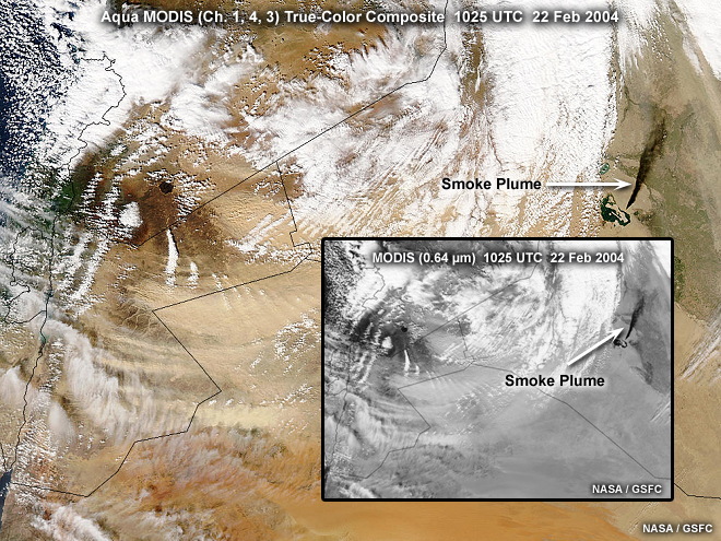
Description:
Aqua MODIS true-color composite image showing a black smoke plume from an oil fire blowing dust and cloud cover over Northern Iraq, taken at 1025 UTC on February 22, 2004.
File Name:
s5p2_oil_smoke_me.jpg
Credits:
NASA / GSFC
Copyright Terms:
COMET Standard Terms
of Use
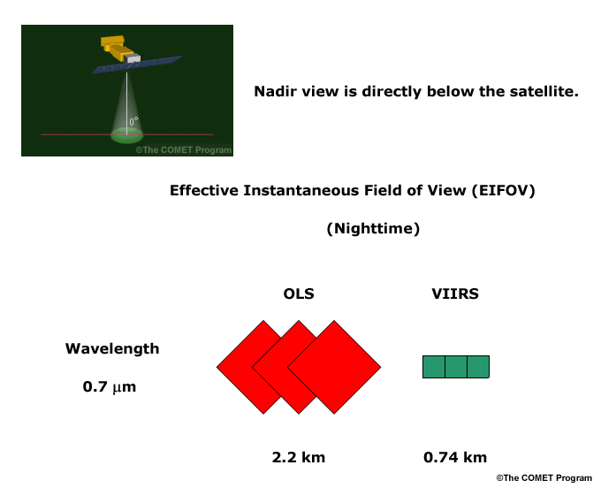
Description:
Illustration comparing the Effective Instantaneous Field of View (EIFOV) for the nighttime visible channels on DMSP OLS and VIIRS.
File Name:
s6p1a.gif
Credits:
©The COMET Program
Copyright Terms:
COMET Standard Terms
of Use
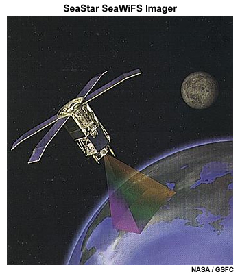
Description:
Illustration of the Seastar polar-orbiting satellite with SeaWiFS imager on board in orbit.
File Name:
seastar_orbit.jpg
Credits:
NASA / GSFC
Copyright Terms:
COMET Standard Terms
of Use

Description:
A SeaWiFS false-color dust enhancement product image over the eastern Atlantic showing a dust plume in advance of an oceanic frontal system, taken at 1324 UTC on February 12, 2002.
File Name:
seawifs_dust_5_12.jpg
Credits:
U.S. Navy / NRL
Copyright Terms:
COMET Standard Terms
of Use
Description:
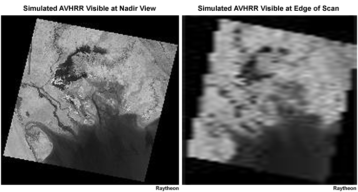
Comparison of simulated AVHRR visible images near nadir vs. edge of scan using Landsat data over the Middle East.
File Name:
sim_avhrr_nadir_vs_edge_4_6.jpg
Credits:
Raytheon (on both images)
Copyright Terms:
COMET Standard Terms
of Use
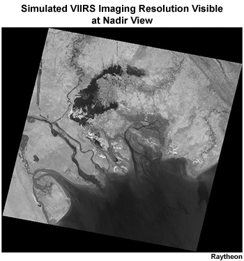
Description:
Simulation of a VIIRS nadir pass for a 0.38 km "imaging" resolution visible image over the Middle East using Landsat data.
File Name:
sim_viirs_imaging_2_2.jpg
Credits:
Raytheon
Copyright Terms:
COMET Standard Terms
of Use
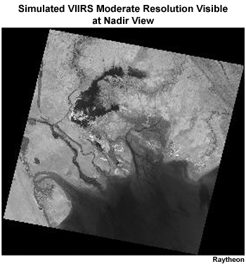
Description:
Simulation of a VIIRS nadir pass for a 0.76 km "moderate" resolution visible image over the Middle East using Landsat data.
File Name:
sim_viirs_mod_2_2.jpg
Credits:
Raytheon
Copyright Terms:
COMET Standard Terms
of Use
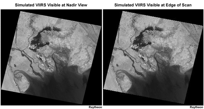
Description:
Comparison of simulated VIIRS visible images near nadir vs. edge of scan using Landsat data over the Middle East.
File Name:
sim_viirs_nadir_vs_edge_4_6.jpg
Credits:
Raytheon (on both images)
Copyright Terms:
COMET Standard Terms
of Use
Description:
Illustration of the EOS-Terra polar-orbiting satellite in orbit.
File Name:
terra_lo_350.jpg
Credits:
NASA / JPL
Copyright Terms:
COMET Standard Terms
of Use
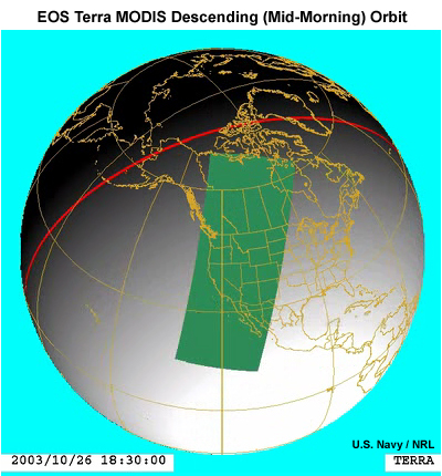
Description:
Illustration showing a descending orbit and ground coverage for the EOS-Terra MODIS imager over the U.S. during late morning local time at 18:30 UTC on October 26, 2003.
File Name:
terra_orbit_1_6.jpg
Credits:
U.S. Navy / NRL
Copyright Terms:
COMET Standard Terms
of Use

Description:
DMSP OLS nighttime visible image over the southern U.S. showing clouds and city lights at night under first quarter moon conditions on the night of March 1, 2004.
File Name:
test_q11_ols_nvis.jpg
Credits:
U.S. Navy / NRL
Copyright Terms:
COMET Standard Terms
of Use

Description:
DMSP OLS nighttime visible image over the southern U.S. showing city lights and lightning at night under new moon conditions at 0220 UTC on April 11, 2004.
File Name:
test_q15_ols_nvis.jpg
Credits:
U.S. Navy / NRL
Copyright Terms:
COMET Standard Terms
of Use
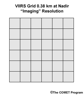
Description:
Illustration of the VIIRS 0.38 km grid for the "imaging" resolution channels at nadir view.
File Name:
viirs_2_2_imaging_res_grid.gif
Credits:
©The COMET Program
Copyright Terms:
COMET Standard Terms
of Use
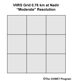
Description:
Illustration of the VIIRS 0.38 km grid for the "moderate" resolution channels at nadir view.
File Name:
viirs_2_2_moderate_res_grid.gif
Credits:
©The COMET Program
Copyright Terms:
COMET Standard Terms
of Use
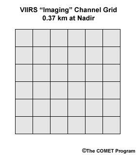
Description:
VIIRS imaging channel grid, 0.37 km at nadir viewing angles.
File Name:
viirs_2_3.gif
Credits:
©The COMET Program
Copyright Terms:
COMET Standard Terms
of Use
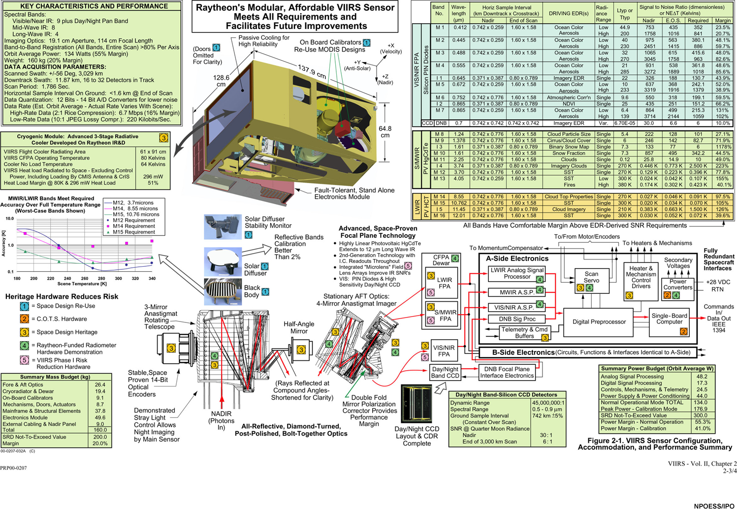
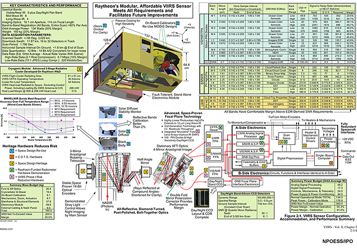
Description:
Raytheon chart and graphic shouwing VIIRS engineering and performance specifications.
File Name:
viirs_foldout.jpg
Credits:
NPOESS / IPO
Copyright Terms:
COMET Standard Terms
of Use
Description:
Raytheon chart and graphic shouwing VIIRS engineering and performance specifications.
File Name:
viirs_foldout_sm.jpg
Credits:
NPOESS / IPO
Copyright Terms:
COMET Standard Terms
of Use
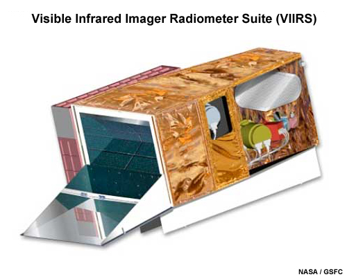
Description:
Artist's rendition of the VIIRS (Visible Infrared Imager Radiometer Suite) imager.
File Name:
viirs_imager.jpg
Credits:
NASA / GSFC
Copyright Terms:
COMET Standard Terms
of Use
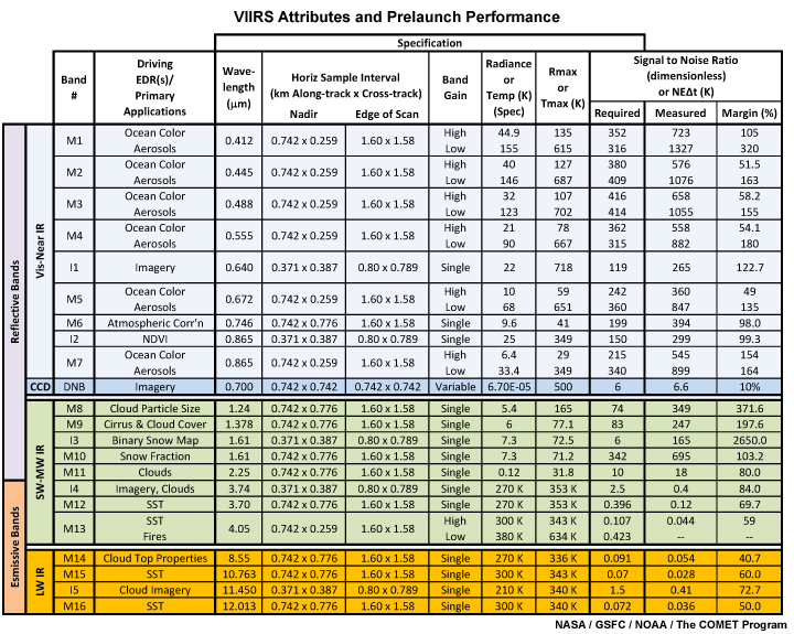
Description:
VIIRS spectral, spatial, and radiometric attributes and driving EDRs (Environmental Data Records) table.
File Name:
viirs_prelaunch_perf_table.jpg
Credits:
NASA / GSFC / NOAA / The COMET Program
Copyright Terms:
COMET Standard Terms
of Use