Media Gallery
Media elements used in this module are protected by a variety of copyright licenses. Please use the "copyright terms" link associated with each item below for more information.
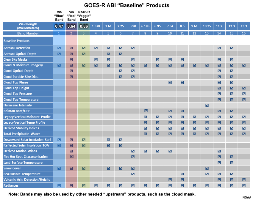
Description:
Table of GOES-R ABI "Baseline" products
File Name:
abi_bands_vs_products_baseline_vis.jpg
Credits:
NOAA
Copyright Terms:
COMET Standard Terms of Use
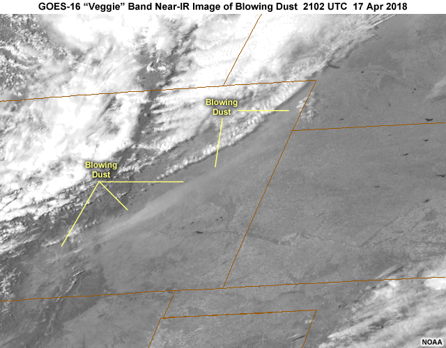
Description:
GOES-16 ABI 0.86 micrometer "veggie" band 3 near-infrared image of blowing dust over over Colorado during mid-afternoon on April 17, 2018
File Name:
abi_dust_nir3_g16.jpg
Credits:
NOAA
Copyright Terms:
COMET Standard Terms of Use
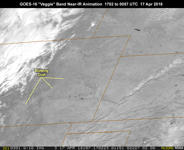
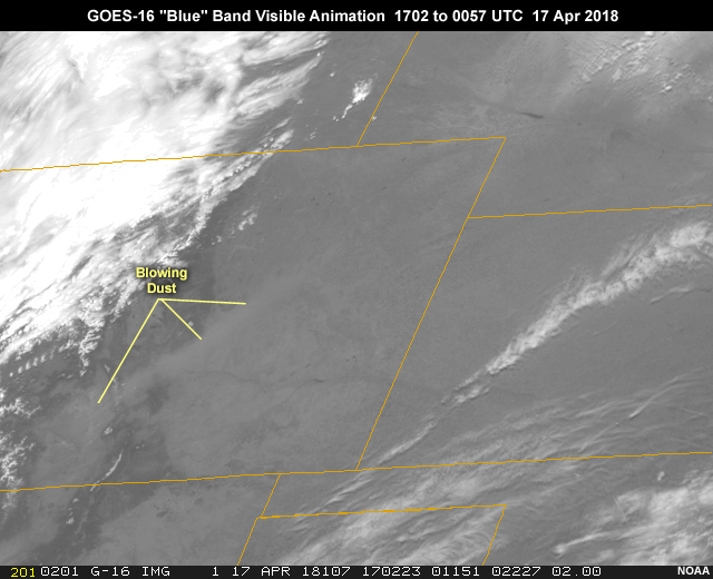
Description:
GOES-16 ABI 0.86 micrometer "veggie" band 3 near-infrared imagery showing blowing dust and smoke in strong southwesterly flow associated with a strong midlatitude cyclone developing in northeastern Colorado during the daylight hours from 1702 to 0057 UTC on April 17, 2018
File Name:
abi_dust_nir3_g16_ani.mp4
Credits:
NOAA
Copyright Terms:
COMET Standard Terms of Use
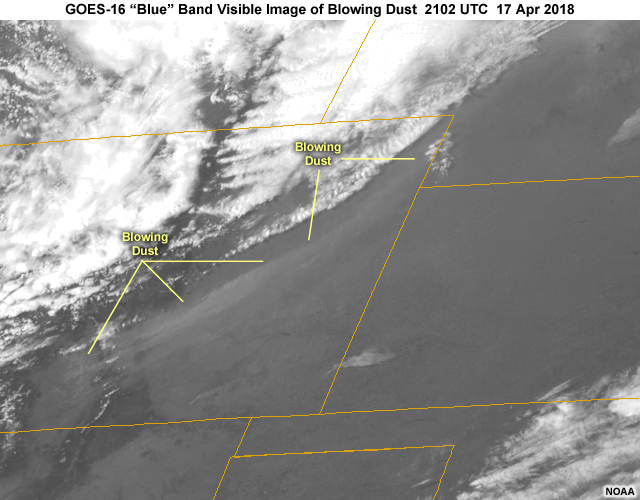
Description:
GOES-16 ABI 0.47 micrometer "blue" band 1 visible image of blowing dust over over Colorado during mid-afternoon on April 17, 2018
File Name:
abi_dust_vis1_g16.jpg
Credits:
NOAA
Copyright Terms:
COMET Standard Terms of Use
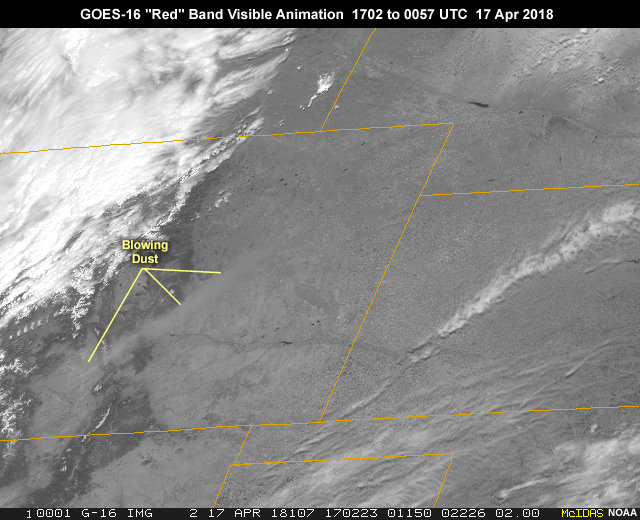
Description:
GOES-16 ABI 0.47 micrometer "blue" band 1 visible imagery showing blowing dust and smoke in strong southwesterly flow associated with a strong midlatitude cyclone developing in northeastern Colorado during the daylight hours from 1702 to 0057 UTC on April 17, 2018
File Name:
abi_dust_vis1_g16_ani.mp4
Credits:
NOAA
Copyright Terms:
COMET Standard Terms of Use
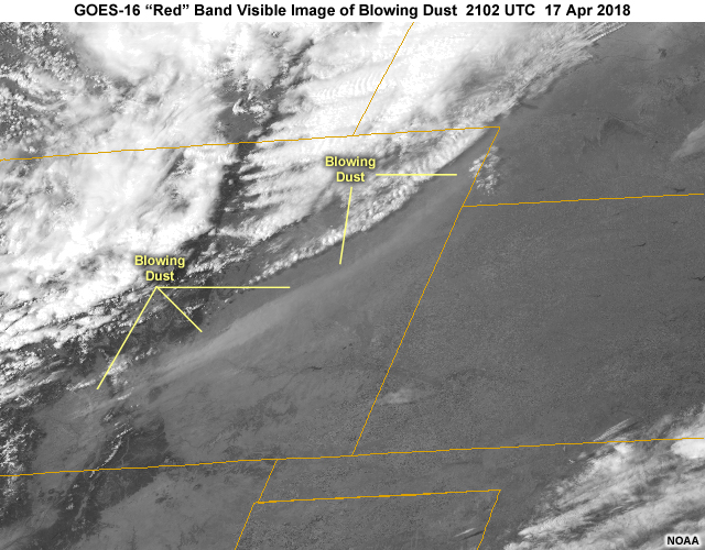
Description:
GOES-16 ABI 0.64 micrometer "red" band 2 visible image of blowing dust over over Colorado during mid-afternoon on April 17, 2018
File Name:
abi_dust_vis2_g16.jpg
Credits:
NOAA
Copyright Terms:
COMET Standard Terms of Use
Description:
GOES-16 ABI 0.64 micrometer "red" band 2 visible imagery showing blowing dust and smoke in strong southwesterly flow associated with a strong midlatitude cyclone developing in northeastern Colorado during the daylight hours from 1702 to 0057 UTC on April 17, 2018
File Name:
abi_dust_vis2_g16_ani.mp4
Credits:
NOAA
Copyright Terms:
COMET Standard Terms of Use
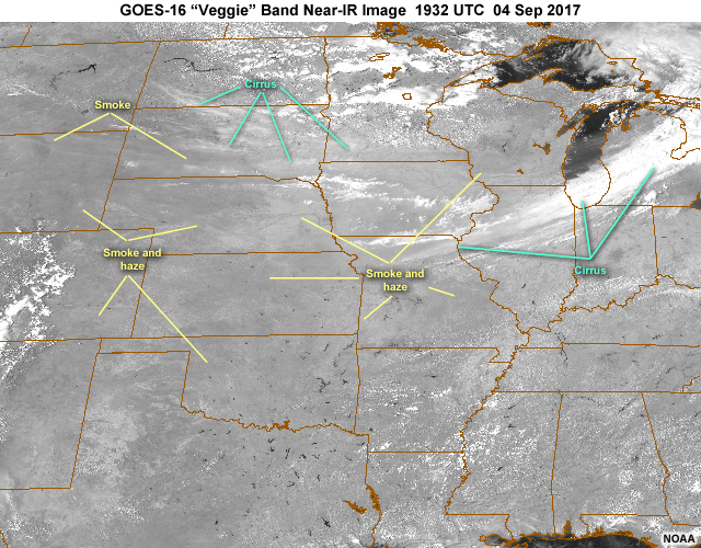
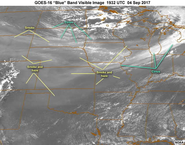
Description:
GOES-16 ABI 0.86 micrometer "veggie" band 3 near-infrared image of smoke and haze from western fires, over the central U.S. during early afternoon on Sep 4, 2017
File Name:
abi_haze_nir3_g16.jpg
Credits:
NOAA
Copyright Terms:
COMET Standard Terms of Use
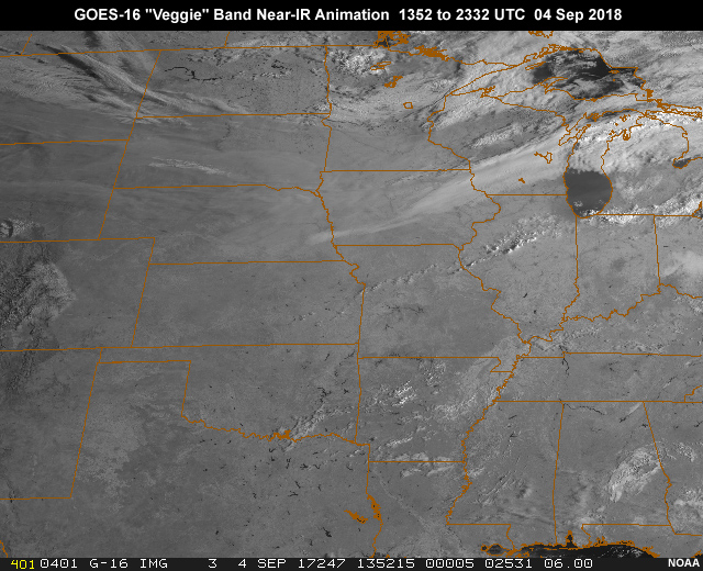
Description:
GOES-16 ABI 0.86 micrometer "veggie" band 3 near-infrared animation showing haze and smoke from western fires, over the central U.S. during daylight hours from 13:52 to 23:32 UTC on Sep 4, 2018
File Name:
abi_haze_nir3_g16_ani.mp4
Credits:
NOAA
Copyright Terms:
COMET Standard Terms of Use
Description:
GOES-16 ABI 0.47 micrometer "blue" band 1 visible image of smoke and haze from western fires, over the central U.S. during early afternoon on Sep 4, 2017
File Name:
abi_haze_vis1_g16.jpg
Credits:
NOAA
Copyright Terms:
COMET Standard Terms of Use
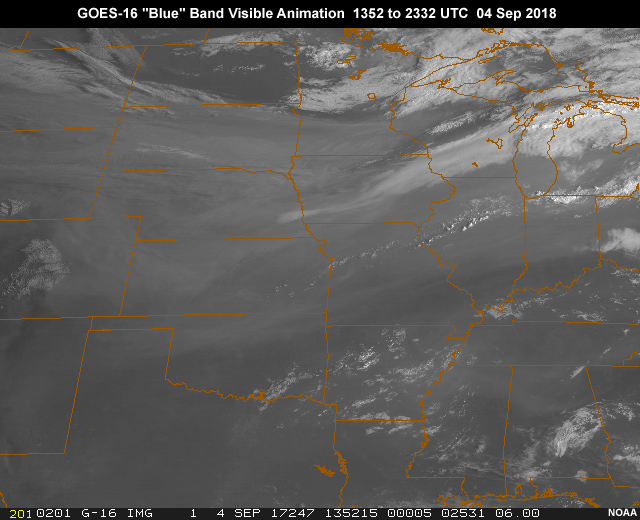
Description:
GOES-16 ABI 0.47 micrometer "blue" band 1 visible animation showing haze and smoke from western fires, over the central U.S. during daylight hours from 13:52 to 23:32 UTC on Sep 4, 2018
File Name:
abi_haze_vis1_g16_ani.mp4
Credits:
NOAA
Copyright Terms:
COMET Standard Terms of Use
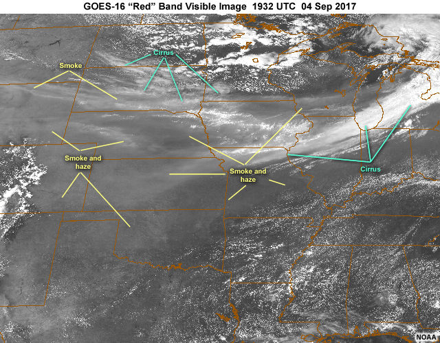
Description:
GOES-16 ABI 0.64 micrometer "red" band 2 visible image of smoke and haze from western fires, over the central U.S. during early afternoon on Sep 4, 2017
File Name:
abi_haze_vis2_g16.jpg
Credits:
NOAA
Copyright Terms:
COMET Standard Terms of Use
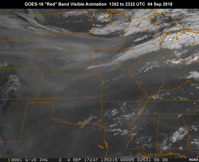
Description:
GOES-16 ABI 0.64 micrometer "red" band 2 visible animation showing haze and smoke from western fires, over the central U.S. during daylight hours from 13:52 to 23:32 UTC on Sep 4, 2018
File Name:
abi_haze_vis2_g16_ani.mp4
Credits:
NOAA
Copyright Terms:
COMET Standard Terms of Use
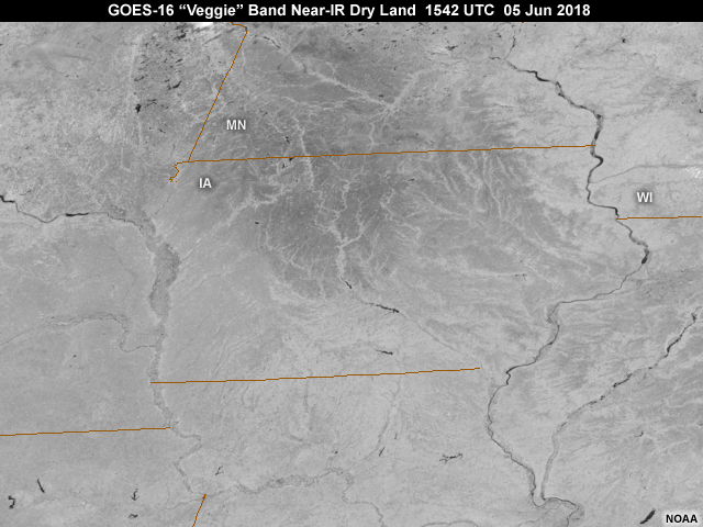
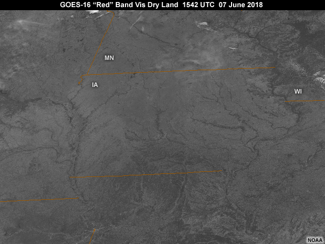
Description:
GOES-16 0.86 micrometer near-IR "veggie" band image showing dry land conditions before heavy rainfall over Iowa and southern Minnesota as seen at 10:42 am local time on June 7, 2018
File Name:
abi_nir3_dry_land_upmw_g16.jpg
Credits:
NOAA
Copyright Terms:
COMET Standard Terms of Use
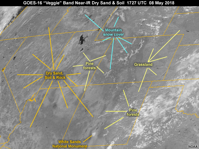
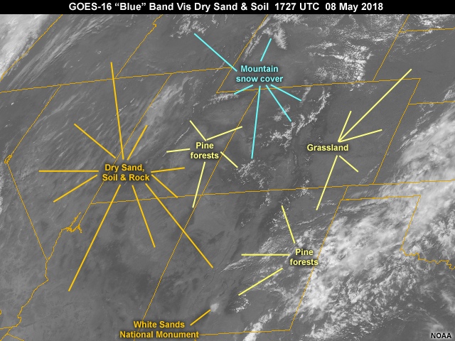
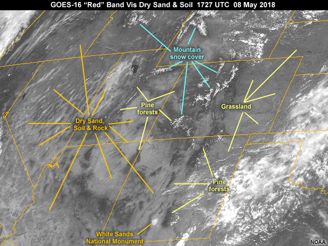
Description:
GOES-16 0.86 micrometer near-infrared image showing dry sand, soil and other land features over the west and southwestern U.S. at 1727 UTC on May 8, 2018
File Name:
abi_nir3_dry_land_wus_g16.jpg
Credits:
NOAA
Copyright Terms:
COMET Standard Terms of Use
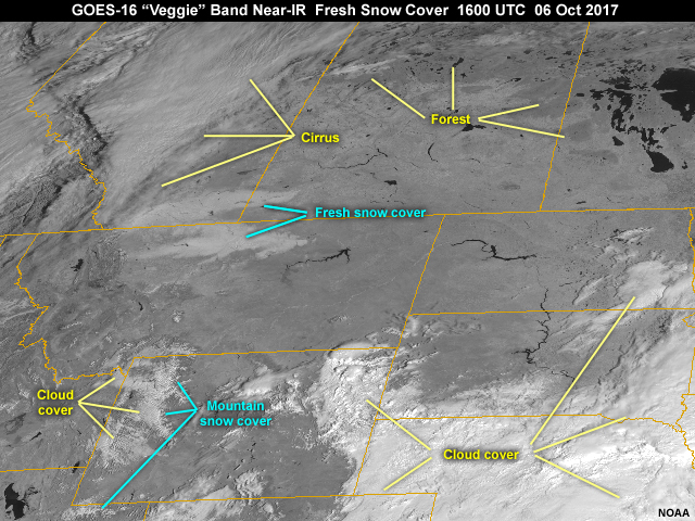
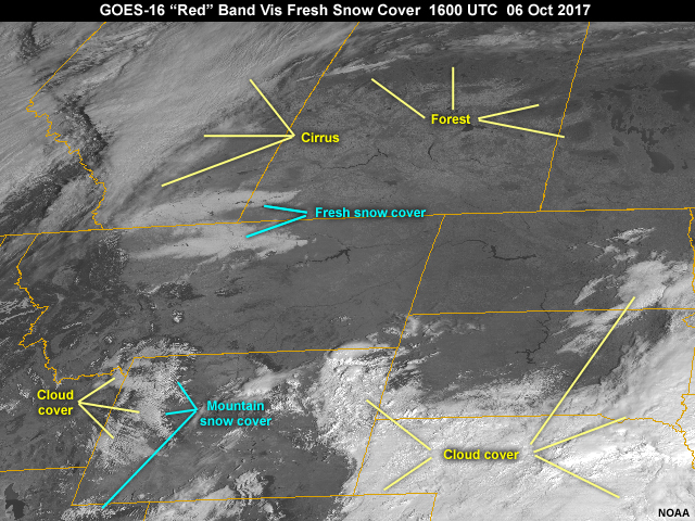
Description:
GOES-16 0.86 micrometer near-infrared image showing fresh snow cover and other land cover types over portions of northern Montana on 6 October, 2017 following an early season winter storm system
File Name:
abi_nir3_fresh_snow_cover_g16.jpg
Credits:
NOAA
Copyright Terms:
COMET Standard Terms of Use
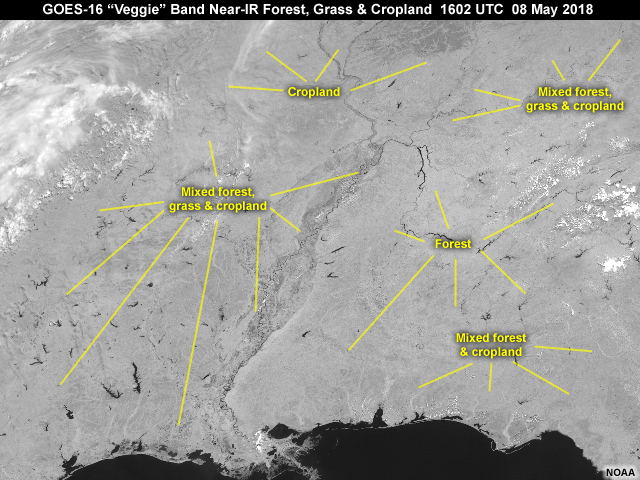
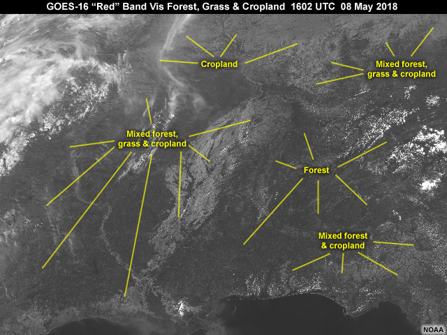
Description:
GOES-16 0.86 micrometer near-infrared image showing forest, grass and cropland over southeastern U.S. at 1602 UTC on May 8, 2018
File Name:
abi_nir3_grass_forest_sus_g16.jpg
Credits:
NOAA
Copyright Terms:
COMET Standard Terms of Use
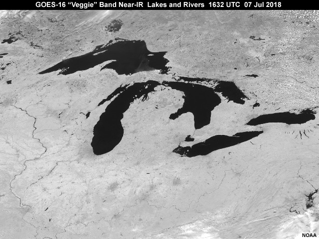
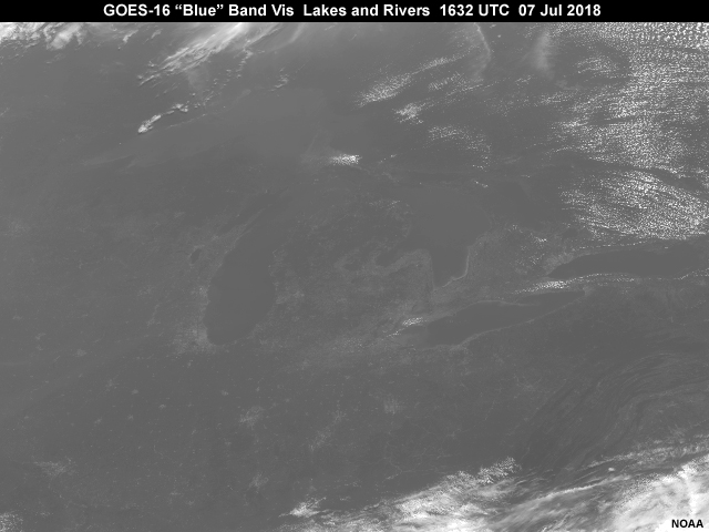
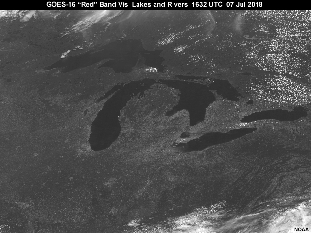
Description:
GOES-16 0.86 micrometer near-infrared image showing the Great Lakes region over northern U.S. during late morning local time on July 7, 2018
File Name:
abi_nir3_lakes_noglint_g16.jpg
Credits:
NOAA
Copyright Terms:
COMET Standard Terms of Use
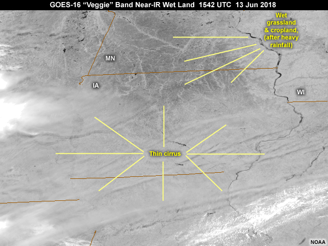
Description:
GOES-16 0.86 micrometer near-IR "veggie" band image showing dry land conditions after heavy rainfall over Iowa and southern Minnesota as seen at 10:42 am local time on June 7, 2018
File Name:
abi_nir3_wet_land_upmw_g16.jpg
Credits:
NOAA
Copyright Terms:
COMET Standard Terms of Use
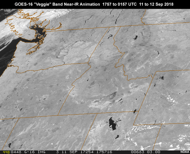
Description:
GOES-16 ABI 0.86 micrometer "veggie" band 3 near-infrared image animation showing smoke from wildfires over Pacific Northwest during daylight hours from 17:57 to 01:57 UTC on Sep 11, 2018
File Name:
abi_smoke_nir3_g16_ani.mp4
Credits:
NOAA
Copyright Terms:
COMET Standard Terms of Use
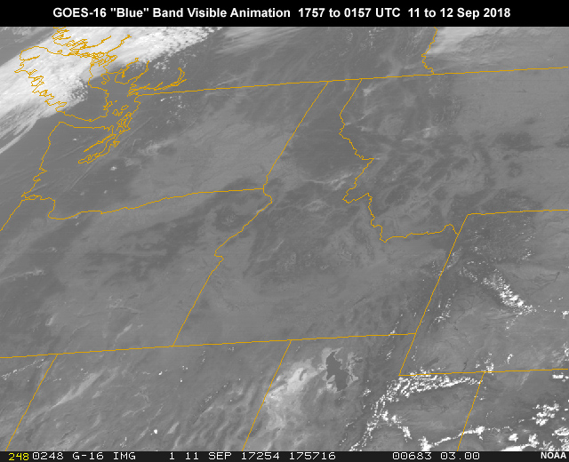
Description:
GOES-16 ABI 0.47 micrometer "blue" band 1 visible image animation showing smoke from wildfires over Pacific Northwest during daylight hours from 17:57 to 01:57 UTC on Sep 11, 2018
File Name:
abi_smoke_vis1_g16_ani.mp4
Credits:
NOAA
Copyright Terms:
COMET Standard Terms of Use
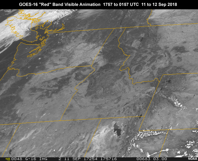
Description:
GOES-16 ABI 0.64 micrometer "red" band 2 visible image animation showing smoke from wildfires over Pacific Northwest during daylight hours from 17:57 to 01:57 UTC on Sep 11, 2018
File Name:
abi_smoke_vis2_g16_ani.mp4
Credits:
NOAA
Copyright Terms:
COMET Standard Terms of Use
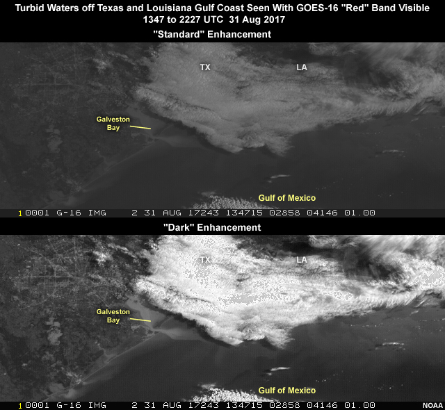
Description:
Turbid water due to river runoff after heavy hurricane Harvey rainfall seen with GOES-16 ABI 0.64 micrometer "red" band imagery over the west Gulf Coast on Aug 31, 2017
File Name:
abi_turbidity_split_g16.mp4
Credits:
NOAA
Copyright Terms:
COMET Standard Terms of Use
Description:
GOES-16 0.47 micrometer visible image showing dry sand, soil and other land features over the west and southwestern U.S. at 1727 UTC on May 8, 2018
File Name:
abi_vis1_dry_land_wus_g16.jpg
Credits:
NOAA
Copyright Terms:
COMET Standard Terms of Use
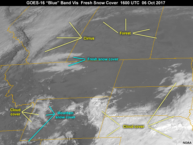
Description:
GOES-16 0.47 micrometer visible image showing fresh snow cover and other land cover types over portions of northern Montana on 6 October, 2017 following an early season winter storm system
File Name:
abi_vis1_fresh_snow_cover_g16.jpg
Credits:
NOAA
Copyright Terms:
COMET Standard Terms of Use
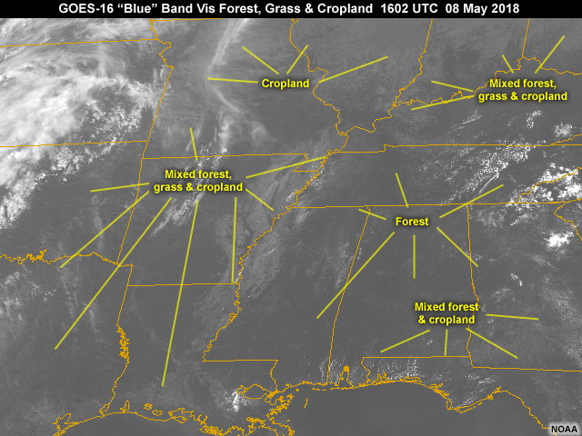
Description:
GOES-16 0.47 micrometer visible image showing forest, grass and cropland over southeastern U.S. at 1602 UTC on May 8, 2018
File Name:
abi_vis1_grass_forest_sus_g16.jpg
Credits:
NOAA
Copyright Terms:
COMET Standard Terms of Use
Description:
GOES-16 0.47 micrometer visible image showing the Great Lakes region over northern U.S. during late morning local time on July 7, 2018
File Name:
abi_vis1_lakes_noglint_g16.jpg
Credits:
NOAA
Copyright Terms:
COMET Standard Terms of Use
Description:
GOES-16 0.64 micrometer visible image showing dry land conditions before heavy rainfall over Iowa and southern Minnesota as seen at 10:42 am local time on June 7, 2018
File Name:
abi_vis2_dry_land_upmw_g16.jpg
Credits:
NOAA
Copyright Terms:
COMET Standard Terms of Use
Description:
GOES-16 0.64 micrometer visible image showing dry sand, soil and other land features over the west and southwestern U.S. at 1727 UTC on May 8, 2018
File Name:
abi_vis2_dry_land_wus_g16.jpg
Credits:
NOAA
Copyright Terms:
COMET Standard Terms of Use
Description:
GOES-16 0.64 micrometer visible image showing fresh snow cover and other land cover types over portions of northern Montana on 6 October, 2017 following an early season winter storm system
File Name:
abi_vis2_fresh_snow_cover_g16.jpg
Credits:
NOAA
Copyright Terms:
COMET Standard Terms of Use
Description:
GOES-16 0.64 micrometer visible image showing forest, grass and cropland over southeastern U.S. at 1602 UTC on May 8, 2018
File Name:
abi_vis2_grass_forest_sus_g16.jpg
Credits:
NOAA
Copyright Terms:
COMET Standard Terms of Use
Description:
GOES-16 0.64 micrometer visible image showing the Great Lakes region over northern U.S. during late morning local time on July 7, 2018
File Name:
abi_vis2_lakes_noglint_g16.jpg
Credits:
NOAA
Copyright Terms:
COMET Standard Terms of Use
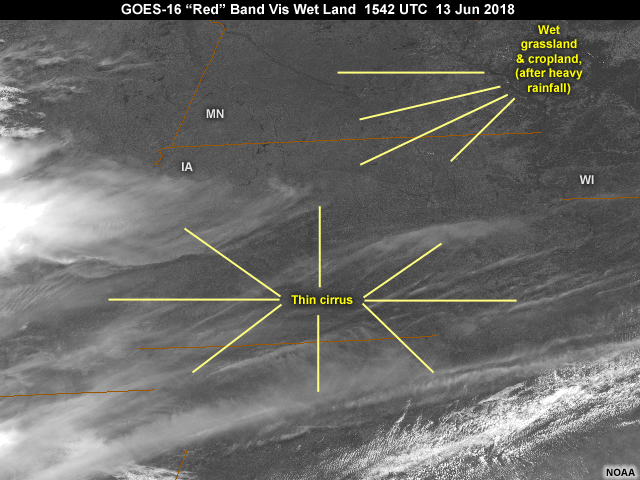
Description:
GOES-16 0.64 micrometer visible image showing wet land conditions following heavy rainfall over portions of northern Iowa and southern Minnesota as seen at 10:42 am local time on June 13, 2018
File Name:
abi_vis2_wet_land_upmw_g16.jpg
Credits:
NOAA
Copyright Terms:
COMET Standard Terms of Use
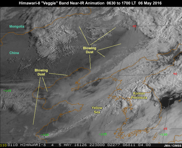
Description:
AHI 0.86 micrometer "veggie" band-4 near-infrared imagery animation showing blowing dust behind a strong midlatitude cyclone and trailing cold front over northeastern China and adjacent ocean waters during daylight hours from 22:30 to 09:00 UTC (6:30 to 17:00 local time) on May 5, 2016
File Name:
ahi_dust_nir4_ani.mp4
Credits:
JMA / CIMSS
Copyright Terms:
COMET Standard Terms of Use
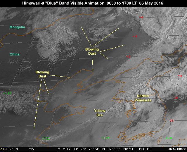
Description:
AHI 0.47 micrometer "blue" band-1 visible imagery showing blowing dust behind a strong midlatitude cyclone and trailing cold front over northeastern China and adjacent ocean waters during daylight hours from 22:30 to 09:00 UTC (6:30 to 17:00 local time) on May 5, 2016
File Name:
ahi_dust_vis1_ani.mp4
Credits:
JMA / CIMSS
Copyright Terms:
COMET Standard Terms of Use
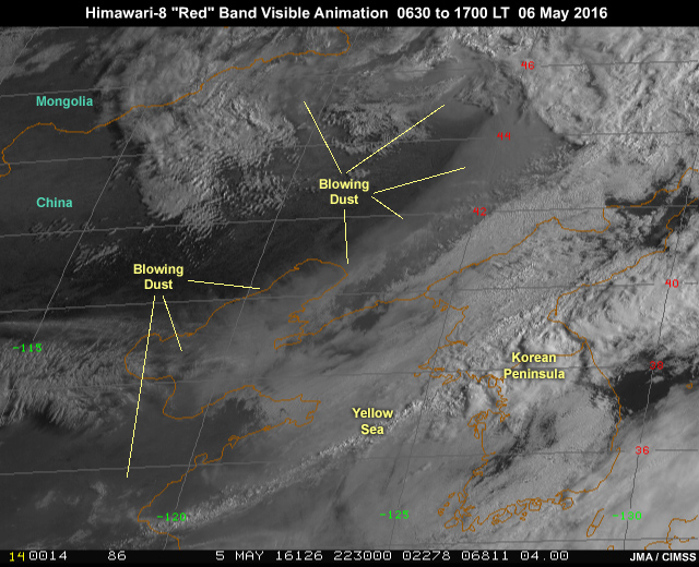
Description:
AHI 0.64 micrometer "blue" band-3 visible imagery showing blowing dust behind a strong midlatitude cyclone and trailing cold front over northeastern China and adjacent ocean waters during daylight hours from 22:30 to 09:00 UTC (6:30 to 17:00 local time) on May 5, 2016
File Name:
ahi_dust_vis3_ani.mp4
Credits:
JMA / CIMSS
Copyright Terms:
COMET Standard Terms of Use
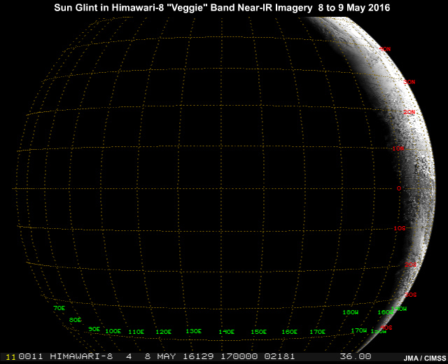
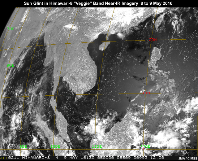
Description:
Sun glint pattern in AHI 0.86 micrometer band-4 near-infrared imagery traveling from east to west across northern hemisphere subtropics as the Earth rotates through one full solar day
File Name:
ahi_glint_nir4_ani.mp4
Credits:
JMA / CIMSS
Copyright Terms:
COMET Standard Terms of Use
Description:
Sun glint pattern in AHI 0.86 micrometer band-4 near-infrared imagery traveling from east to west across South China Sea and Indian Ocean
File Name:
ahi_glint_nir4_zoom_ani.mp4
Credits:
JMA / CIMSS
Copyright Terms:
COMET Standard Terms of Use
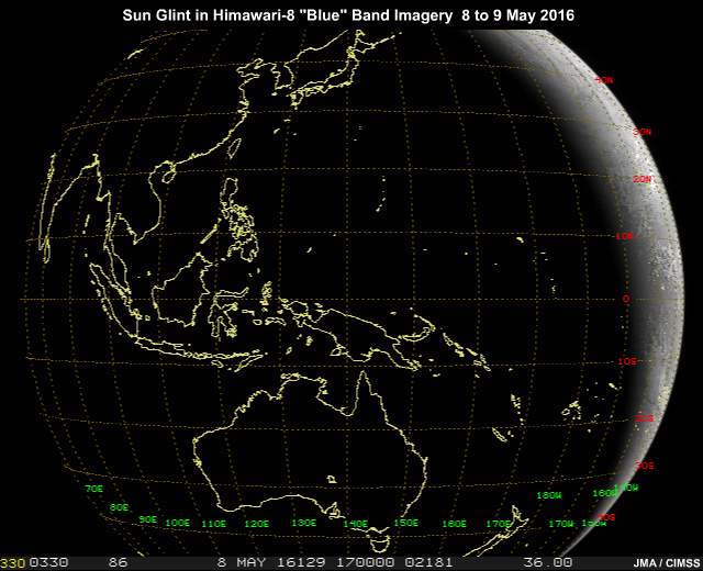
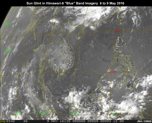
Description:
Sun glint pattern in AHI 0.47 micrometer visible imagery traveling from east to west across northern hemisphere subtropics as the Earth rotates through one full solar day
File Name:
ahi_glint_vis1_ani.mp4
Credits:
JMA / CIMSS
Copyright Terms:
COMET Standard Terms of Use
Description:
Sun glint pattern in AHI 0.47 micrometer visible imagery traveling from east to west across South China Sea and Indian Ocean
File Name:
ahi_glint_vis1_zoom_ani.mp4
Credits:
JMA / CIMSS
Copyright Terms:
COMET Standard Terms of Use
Description:
Sun glint pattern in AHI 0.64 micrometer visible imagery traveling from east to west across northern hemisphere subtropics as the Earth rotates through one full solar day
File Name:
ahi_glint_vis3_ani.mp4
Credits:
JMA / CIMSS
Copyright Terms:
COMET Standard Terms of Use
Description:
Sun glint pattern in AHI 0.64 micrometer visible imagery traveling from east to west across South China Sea and Indian Ocean
File Name:
ahi_glint_vis3_zoom_ani.mp4
Credits:
JMA / CIMSS
Copyright Terms:
COMET Standard Terms of Use
Description:
Sun glint pattern showing internal ocean waves in Himawari-8 AHI 0.64 micrometer visible imagery over the Banda Sea north of Australia during midday on October 29, 2015
File Name:
ahi_glint_waves_vis3_ani.mp4
Credits:
JMA / CIMSS
Copyright Terms:
COMET Standard Terms of Use
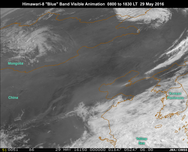
Description:
AHI 0.86 micrometer "veggie" band-4 near-infrared imagery animation showing haze and smog over eastern China throughout daylight hours from 00 to 10:30 UTC (8:00 to 18:30 local time) on May 29, 2016
File Name:
ahi_haze_nir4_ani.mp4
Credits:
JMA / CIMSS
Copyright Terms:
COMET Standard Terms of Use
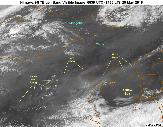
Description:
AHI 0.47 micrometer "blue" band 1 image showing haze and smog over eastern China during early afternoon on May 29, 2016
File Name:
ahi_haze_vis1_0630.jpg
Credits:
JMA / CIMSS
Copyright Terms:
COMET Standard Terms of Use
Description:
AHI 0.47 micrometer "blue" band 1 image animation showing haze and smog over eastern China throughout daylight hours from 00 to 10:30 UTC (8:00 to 18:30 local time) on May 29, 2016
File Name:
ahi_haze_vis1_ani.mp4
Credits:
JMA / CIMSS
Copyright Terms:
COMET Standard Terms of Use
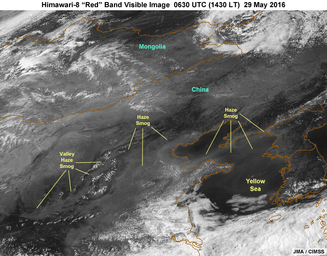
Description:
AHI 0.64 micrometer "red" band 3 image showing haze and smog over eastern China during early afternoon on May 29, 2016
File Name:
ahi_haze_vis3_0630.jpg
Credits:
JMA / CIMSS
Copyright Terms:
COMET Standard Terms of Use
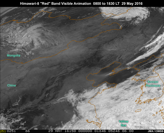
Description:
AHI 0.64 micrometer "blue" band 1 image animation showing haze and smog over eastern China throughout daylight hours from 00 to 10:30 UTC (8:00 to 18:30 local time) on May 29, 2016
File Name:
ahi_haze_vis3_ani.mp4
Credits:
JMA / CIMSS
Copyright Terms:
COMET Standard Terms of Use
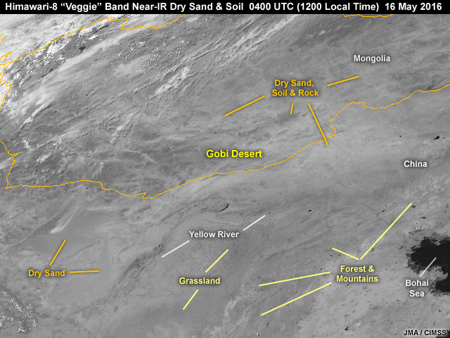
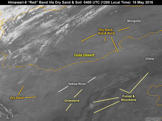
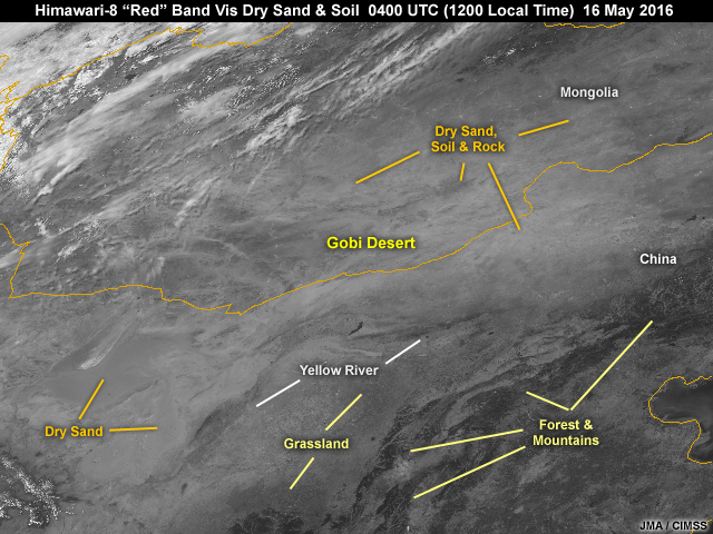
Description:
Himawari-8 0.86 micrometer near-infrared "veggie" band image showing dry sand and soil over southern Mongolia and northern China in Gobi Desert region at noon local time on May 16, 2016
File Name:
ahi_nir4_dry_land_gobi.jpg
Credits:
JMA / CIMSS
Copyright Terms:
COMET Standard Terms of Use
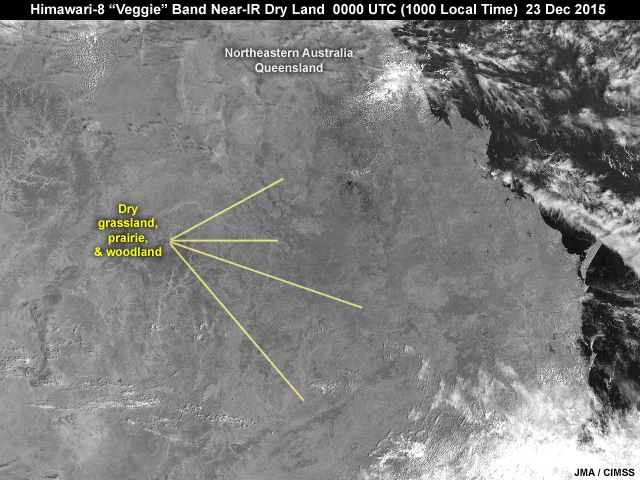
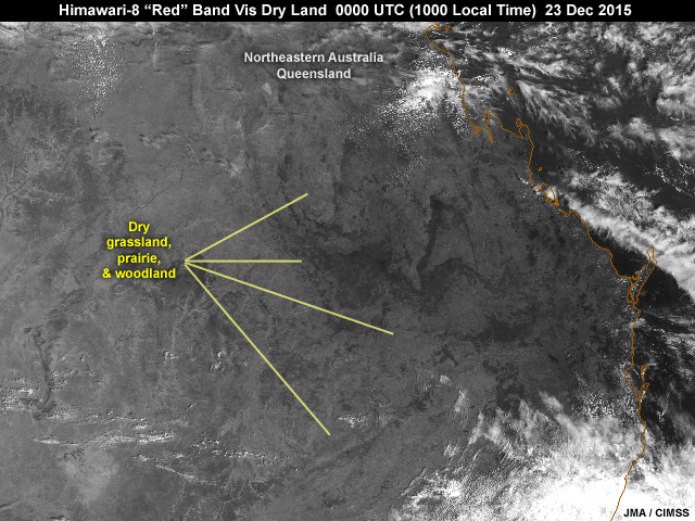
Description:
Himawari-8 0.86 micrometer near-infrared "veggie" band image showing dry land conditions before heavy rainfall over portions of northeastern Australia's Queensland region at 10 am local time on December 23, 2015
File Name:
ahi_nir4_dry_land_neau.jpg
Credits:
JMA / CIMSS
Copyright Terms:
COMET Standard Terms of Use
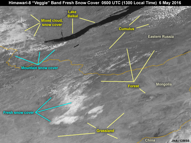
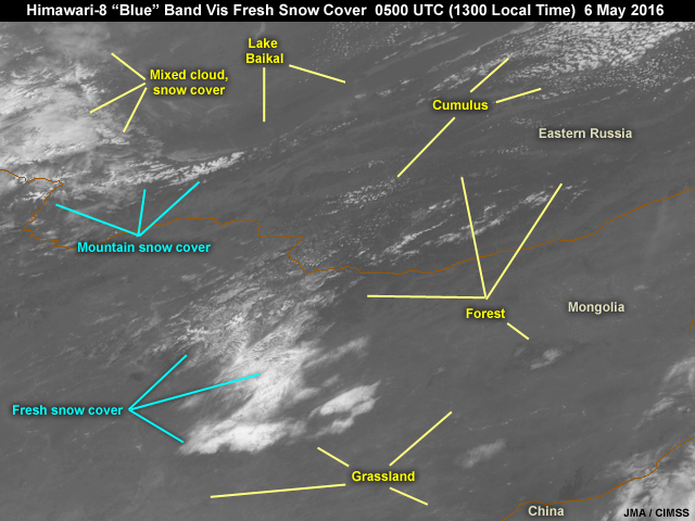
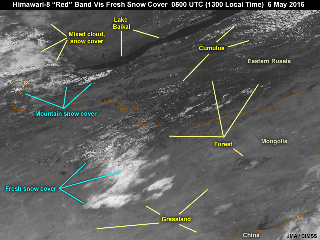
Description:
Himawari-8 0.86 micrometer near-infrared image showing fresh snow cover over portions of northeastern Mongolia following fast moving cyclone from day before on 6 May, 2016
File Name:
ahi_nir4_fresh_snow_cover.jpg
Credits:
JMA / CIMSS
Copyright Terms:
COMET Standard Terms of Use
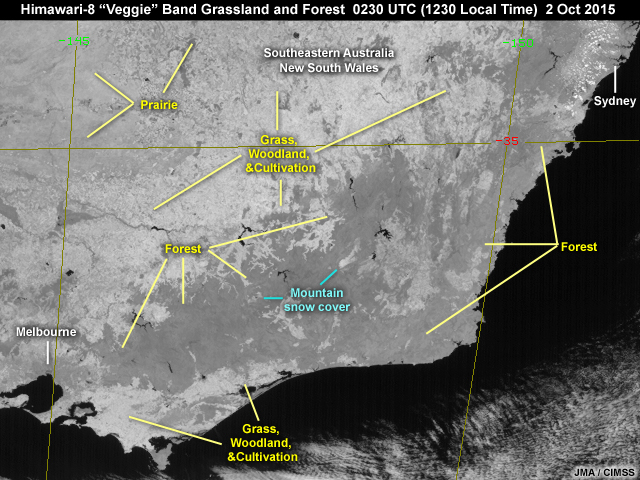
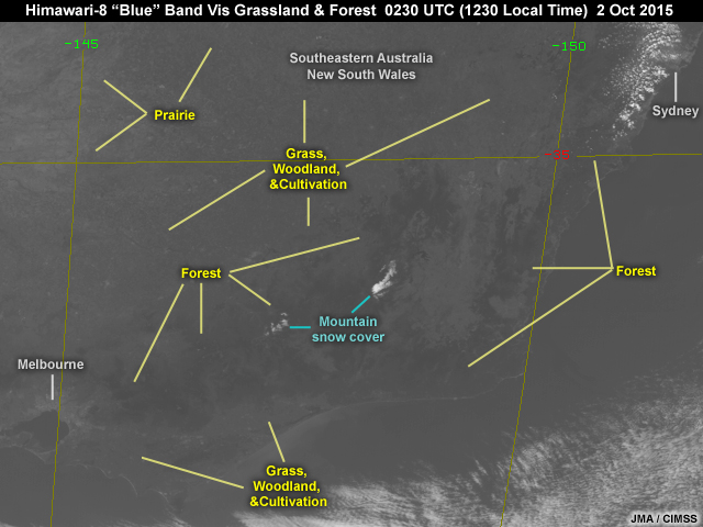
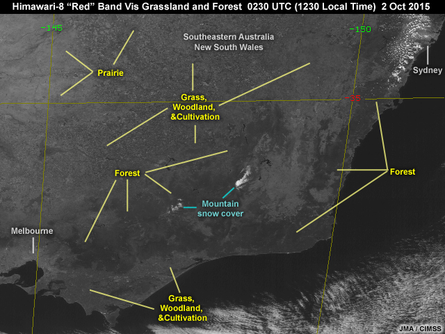
Description:
Himawari-8 0.86 micrometer near-infrared image showing forest, grassland, coastline, and city southeastern Australia, New South Wales, at 12:30 local time on October 2, 2016
File Name:
ahi_nir4_grass_forest_seau.jpg
Credits:
JMA / CIMSS
Copyright Terms:
COMET Standard Terms of Use
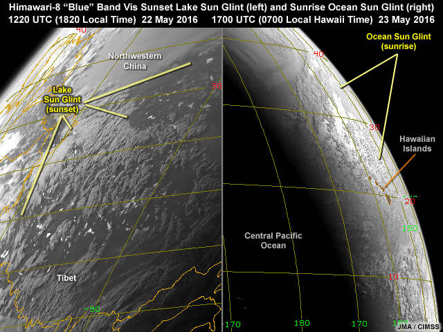
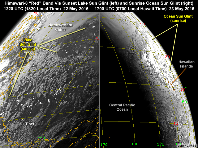
Description:
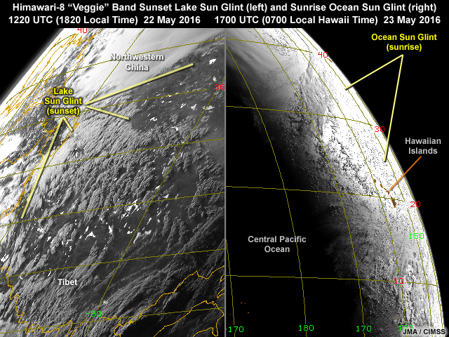
Himawari-8 0.86 micrometer near-infrared image showing sun glint over Central Pacific around Hawaiian Islands at sunrise and on lakes in Tibet at sunset on May 22 and 23, 2016
File Name:
ahi_nir4_lake_ocean_glint.jpg
Credits:
JMA / CIMSS
Copyright Terms:
COMET Standard Terms of Use
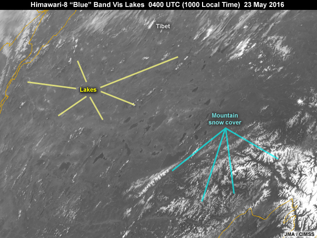
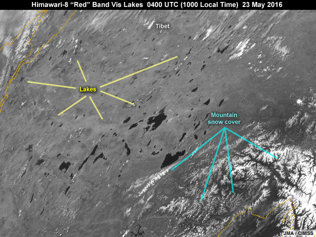
Description:
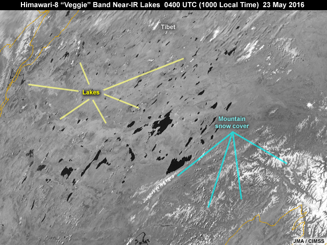
Himawari-8 0.86 micrometer near-infrared image showing lakes in Tibet during mid-morning local time on May 23, 2016
File Name:
ahi_nir4_lakes_noglint.jpg
Credits:
JMA / CIMSS
Copyright Terms:
COMET Standard Terms of Use
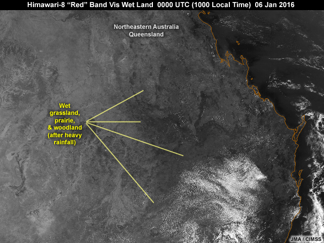
Description:
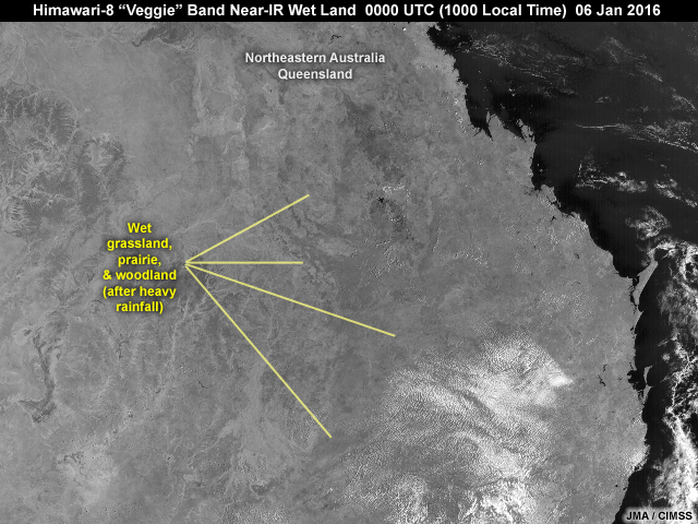
Himawari-8 0.86 micrometer near-infrared "veggie" band image showing wet ground conditions after days of heavy rainfall over portions of northeastern Australia's Queensland region at 10 am local time on January 7, 2016
File Name:
ahi_nir4_wet_land_neau.jpg
Credits:
JMA / CIMSS
Copyright Terms:
COMET Standard Terms of Use
Description:
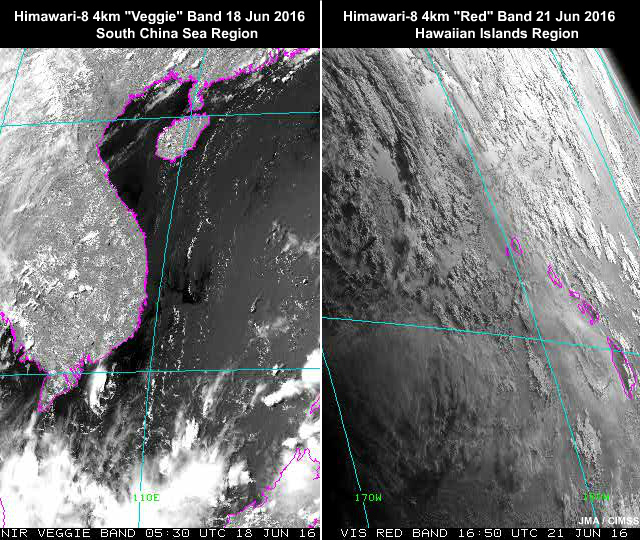
Himawari-8 0.64 and 0.86 micrometer 2-panel image animation showing sun glint over South China Sea region during midday and around and west of Hawaiian Islands at sunrise and on lakes in Tibet at sunset on June 18 and 21, 2016
File Name:
ahi_red_veggie_glint_quiz_ani.mp4
Credits:
JMA / CIMSS
Copyright Terms:
COMET Standard Terms of Use
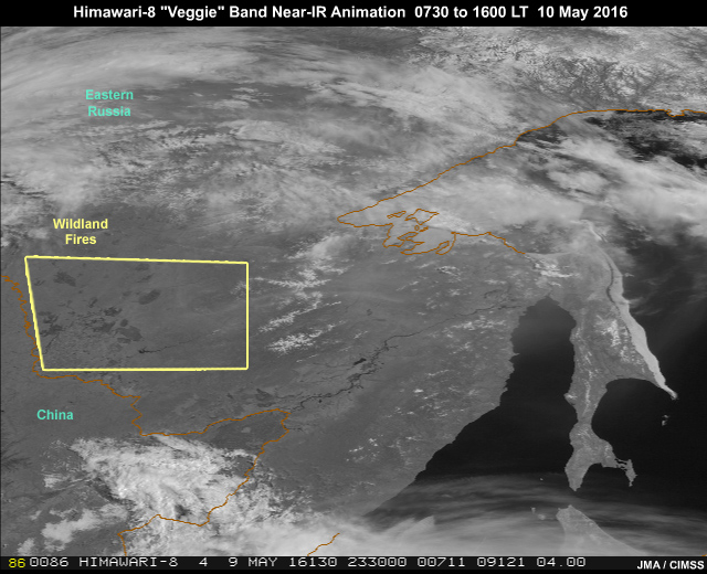
Description:
AHI 0.86 micrometer "veggie" band-4 near-infrared imagery animation showing smoke from wildfires and other land features over eastern Siberia during daylight hours from 23:30 to 08:00 UTC (7:30 to 16:00 local time) on May 10, 2016
File Name:
ahi_smoke_nir4_ani.mp4
Credits:
JMA / CIMSS
Copyright Terms:
COMET Standard Terms of Use
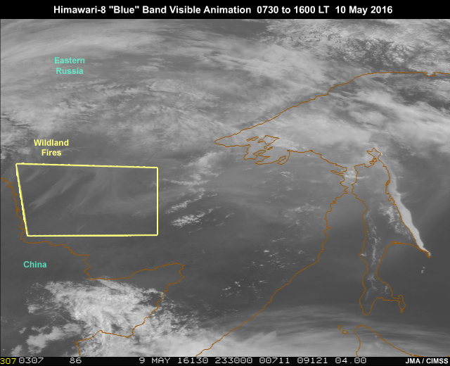
Description:
AHI 0.47 micrometer "blue" band 1 image animation showing smoke from wildfires over eastern Siberia during daylight hours from 23:30 to 08:00 UTC (7:30 to 16:00 local time) on May 10, 2016
File Name:
ahi_smoke_vis1_ani.mp4
Credits:
JMA / CIMSS
Copyright Terms:
COMET Standard Terms of Use
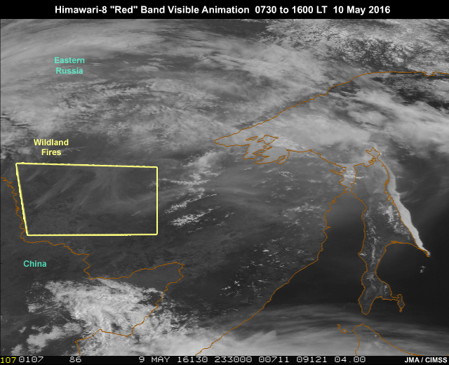
Description:
AHI 0.64 micrometer "red" band 3 image animation showing smoke from wildfires over eastern Siberia during daylight hours from 23:30 to 08:00 UTC (7:30 to 16:00 local time) on May 10, 2016
File Name:
ahi_smoke_vis3_ani.mp4
Credits:
JMA / CIMSS
Copyright Terms:
COMET Standard Terms of Use
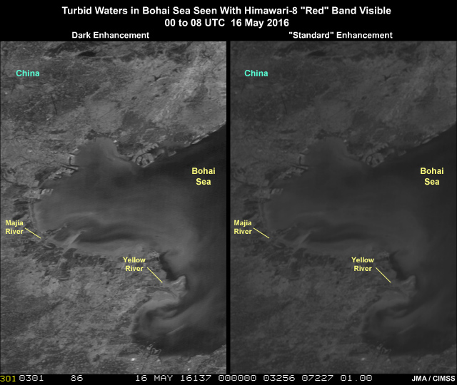
Description:
Turbid water due to river runoff seen with Himawari-8 AHI 0.64 micrometer "red" band imagery in the Bohai Sea off the coast of eastern China on May 16, 2016
File Name:
ahi_turbidity_split.mp4
Credits:
JMA / CIMSS
Copyright Terms:
COMET Standard Terms of Use
Description:
Himawari-8 0.47 micrometer visible image showing dry sand and soil over southern Mongolia and northern China in Gobi Desert region at noon local time on May 16, 2016
File Name:
ahi_vis1_dry_land_gobi.jpg
Credits:
JMA / CIMSS
Copyright Terms:
COMET Standard Terms of Use
Description:
Himawari-8 0.47 micrometer visible image showing fresh snow cover over portions of northeastern Mongolia following fast moving cyclone from day before on 6 May, 2016
File Name:
ahi_vis1_fresh_snow_cover.jpg
Credits:
JMA / CIMSS
Copyright Terms:
COMET Standard Terms of Use
Description:
Himawari-8 0.47 micrometer visible image showing forest, grassland, coastline, and city southeastern Australia, New South Wales, at 12:30 local time on October 2, 2016
File Name:
ahi_vis1_grass_forest_seau.jpg
Credits:
JMA / CIMSS
Copyright Terms:
COMET Standard Terms of Use
Description:
Himawari-8 0.47 micrometer visible images showing sun glint over Central Pacific around Hawaiian Islands at sunrise and on lakes in Tibet at sunset on May 22 and 23, 2016
File Name:
ahi_vis1_lake_ocean_glint.jpg
Credits:
JMA / CIMSS
Copyright Terms:
COMET Standard Terms of Use
Description:
Himawari-8 0.47 micrometer visible image showing lakes in Tibet during mid-morning local time on May 23, 2016
File Name:
ahi_vis1_lakes_noglint.jpg
Credits:
JMA / CIMSS
Copyright Terms:
COMET Standard Terms of Use
Description:
Himawari-8 0.64 micrometer visible image showing dry sand and soil over southern Mongolia and northern China in Gobi Desert region at noon local time on May 16, 2016
File Name:
ahi_vis3_dry_land_gobi.jpg
Credits:
JMA / CIMSS
Copyright Terms:
COMET Standard Terms of Use
Description:
Himawari-8 0.64 micrometer visible image showing dry land conditions before heavy rainfall over portions of northeastern Australia's Queensland region at 10 am local time on December 23, 2015
File Name:
ahi_vis3_dry_land_neau.jpg
Credits:
JMA / CIMSS
Copyright Terms:
COMET Standard Terms of Use
Description:
Himawari-8 0.64 micrometer visible image showing fresh snow cover over portions of northeastern Mongolia following fast moving cyclone from day before on 6 May, 2016
File Name:
ahi_vis3_fresh_snow_cover.jpg
Credits:
JMA / CIMSS
Copyright Terms:
COMET Standard Terms of Use
Description:
Himawari-8 0.64 micrometer visible image showing forest, grassland, coastline, and city southeastern Australia, New South Wales, at 12:30 local time on October 2, 2016
File Name:
ahi_vis3_grass_forest_seau.jpg
Credits:
JMA / CIMSS
Copyright Terms:
COMET Standard Terms of Use
Description:
Himawari-8 0.64 micrometer visible image showing sun glint over Central Pacific around Hawaiian Islands at sunrise and on lakes in Tibet at sunset on May 22 and 23, 2016
File Name:
ahi_vis3_lake_ocean_glint.jpg
Credits:
JMA / CIMSS
Copyright Terms:
COMET Standard Terms of Use
Description:
Himawari-8 0.64 micrometer visible image showing lakes in Tibet during mid-morning local time on May 23, 2016
File Name:
ahi_vis3_lakes_noglint.jpg
Credits:
JMA / CIMSS
Copyright Terms:
COMET Standard Terms of Use
Description:
Himawari-8 0.64 micrometer visible image showing wet ground conditions after days of heavy rainfall over portions of northeastern Australia's Queensland region at 10 am local time on January 7, 2016
File Name:
ahi_vis3_wet_land_neau.jpg
Credits:
JMA / CIMSS
Copyright Terms:
COMET Standard Terms of Use
Description:
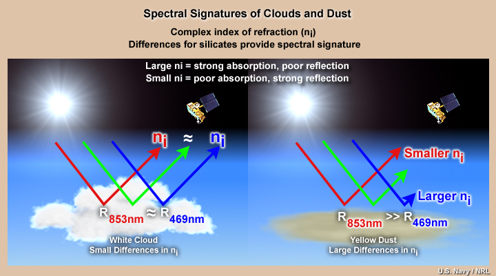
conceptual diagram of reflectance at different color visible wavelengths reflecting off clouds and dust location
File Name:
clouds_dust_spec_sig_vis.jpg
Credits:
U.S. Navy/NRL
Copyright Terms:
COMET Standard Terms of Use
Description:
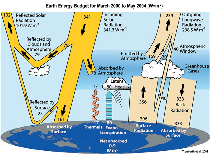
Conceptual diagram showing interactions between incoming solar radiation, Earth's atmosphere and surface
File Name:
earth_energy_budget_incoming.jpg
Credits:
Trenberth et al. 2009
Copyright Terms:
COMET Standard Terms of Use
Description:
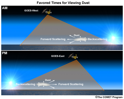
2-panel graphic depicting favored times for viewing dust with GOES West (morning) and GOES-East (afternoon)
File Name:
favored_viewing_times_for_viewingdust_goes.jpg
Credits:
�The COMET Program
Copyright Terms:
COMET Standard Terms of Use
Description:
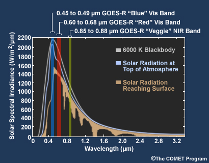
Plot showing GOES R-U ABI visible channel spectral coverage within the solar emitted radiation spectrum
File Name:
incoming_solar_abi_vis_nir3_bands.jpg
Credits:
�The COMET Program
Copyright Terms:
COMET Standard Terms of Use
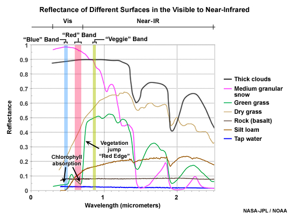
Description:
Reflectance of clouds and different surfaces in the visible to near infrared with GOES-R ABI's two visible bands and near-ir 0.86 micrometer band indicated
File Name:
sfc_snow_cloud_refl_goesr_vis_nir4.jpg
Credits:
NASA-JPL / NOAA
Copyright Terms:
COMET Standard Terms of Use
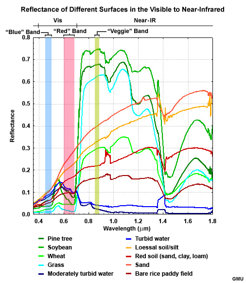
Description:
Reflectance of different surfaces in the visible to near infrared with GOES-R ABI's two visible bands and near-ir 0.86 micrometer band indicated
File Name:
sfc_type_refl_goesr_vis_nir.jpg
Credits:
GMU
Copyright Terms:
COMET Standard Terms of Use
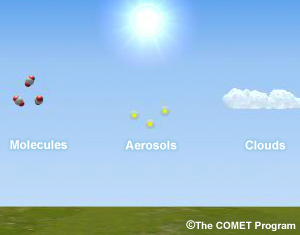
Description:
Animation of incoming solar radiation reflecting off Earth's surface and scattered by atmospheric molecules, aerosols, and clouds
File Name:
sm2cm5_ani.mp4
Credits:
�The COMET Program
Copyright Terms:
COMET Standard Terms of Use
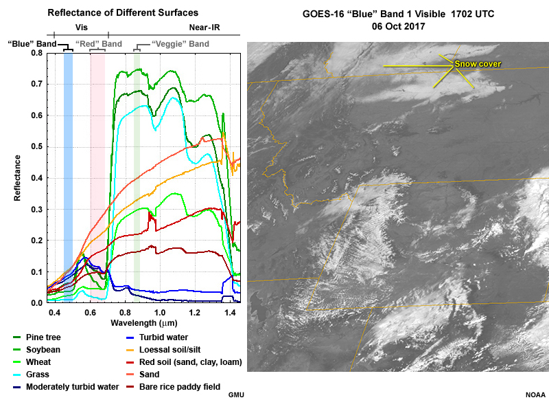
Description:
Left side plot shows visible reflectances and right side a GOES-16 ABI 0.47 micrometer "blue" band image over northern Rocky Mountain region of U.S.
File Name:
vis_refl_abi_band1_g16.jpg
Credits:
GMU NOAA
Copyright Terms:
COMET Standard Terms of Use
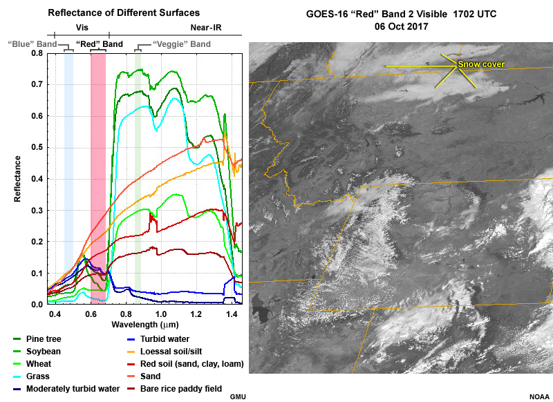
Description:
Left side plot shows visible reflectances and right side a GOES-16 ABI 0.64 micrometer "red" band image over the northern Rocky Mountain region of the U.S.
File Name:
vis_refl_abi_band2_g16.jpg
Credits:
GMU NOAA
Copyright Terms:
COMET Standard Terms of Use
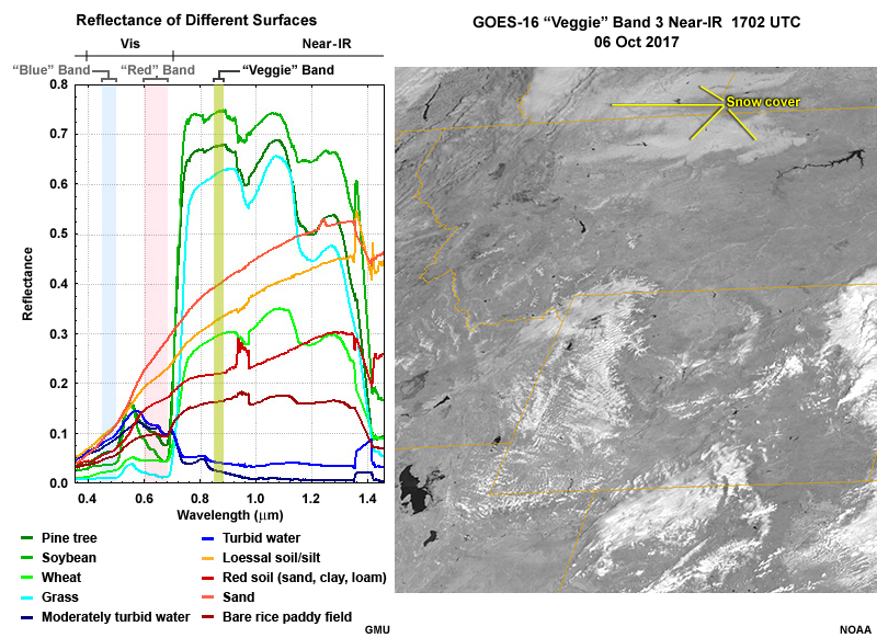
Description:
Left side plot shows visible and near-infrared reflectances and right side a GOES-16 AB 0.86 micrometer vegetation or "veggie" band near-IR image over the northern Rocky Mountain region of the U.S.
File Name:
vis_refl_abi_band3_g16.jpg
Credits:
GMU NOAA
Copyright Terms:
COMET Standard Terms of Use
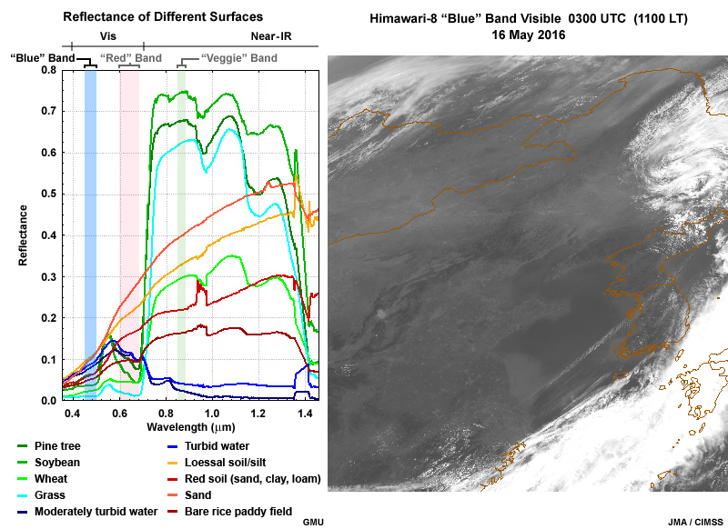
Description:
Right side plot shows visible reflectances and left side a Himawari-8 0.47 micrometer "blue" band image over eastern China and adjacent Yellow Sea and East China Sea regions.
File Name:
vis_refl_ahi_band1.jpg
Credits:
GMU JMA/CIMSS
Copyright Terms:
COMET Standard Terms of Use
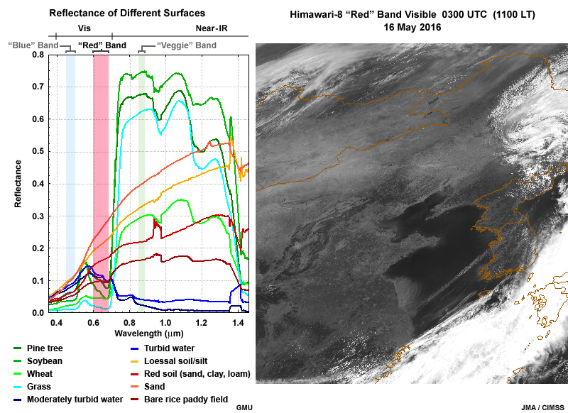
Description:
Right side plot shows visible reflectances and left side a Himawari-8 0.64 micrometer "red" band image over eastern China and adjacent Yellow Sea and East China Sea regions.
File Name:
vis_refl_ahi_band3.jpg
Credits:
GMU JMA/CIMSS
Copyright Terms:
COMET Standard Terms of Use
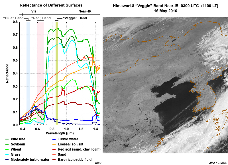
Description:
Left side plot shows visible and near-infrared reflectances and right side a Himawari-8 0.86 micrometer vegetation or "veggie" band image over eastern China and adjacent Yellow Sea and East China Sea regions.
File Name:
vis_refl_ahi_band4.jpg
Credits:
GMU JMA/CIMSS
Copyright Terms:
COMET Standard Terms of Use