Media Gallery
Media elements used in this module are protected by a variety of copyright licenses. Please use the "copyright terms" link associated with each item below for more information.
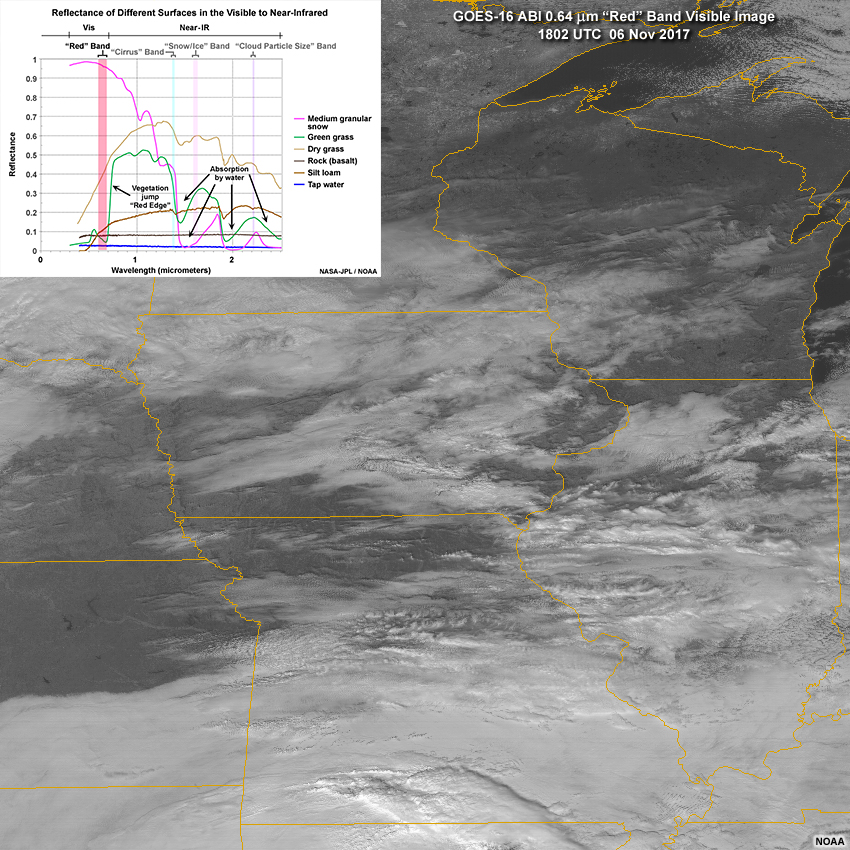
Description:
GOES-16 ABI 0.64 micrometer "red" band visible image showing a variety cloud and surface types on November 6, 2017 with near-IR reflectance spectra overlay
File Name:
abi_b2_red_band_refl_plot_g16.jpg
Credits:
NOAA
Copyright Terms:
COMET Standard Terms of Use
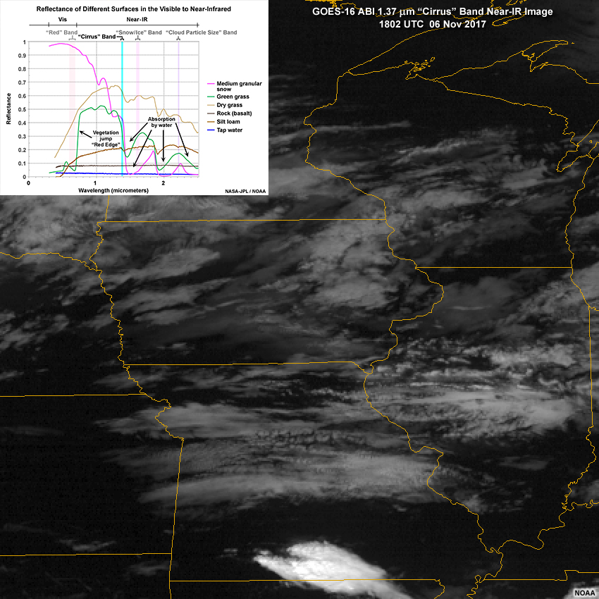
Description:
GOES-16 ABI 1.37 micrometer "cirrus" band near-infrared image showing a variety cloud and surface types on November 6, 2017 with near-IR reflectance spectra overlay
File Name:
abi_b4_cirrus_band_refl_plot_g16.jpg
Credits:
NOAA
Copyright Terms:
COMET Standard Terms of Use
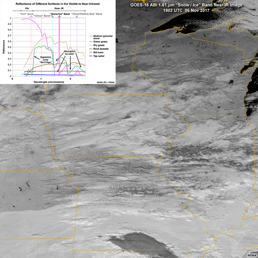
Description:
GOES-16 ABI 1.61 micrometer "snow/ice" band near-infrared image showing a variety cloud and surface types on November 6, 2017 with near-IR reflectance spectra overlay
File Name:
abi_b5_snowice_band_refl_plot_g16.jpg
Credits:
NOAA
Copyright Terms:
COMET Standard Terms of Use
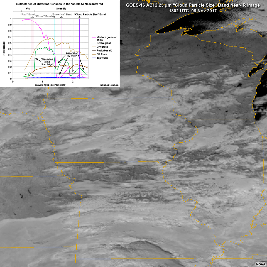
Description:
GOES-16 ABI 2.25 micrometer "cloud particle size" band near-infrared image showing a variety cloud and surface types on November 6, 2017 with near-IR reflectance spectra overlay
File Name:
abi_b6_cldpartsize_band_refl_plot_g16.jpg
Credits:
NOAA
Copyright Terms:
COMET Standard Terms of Use
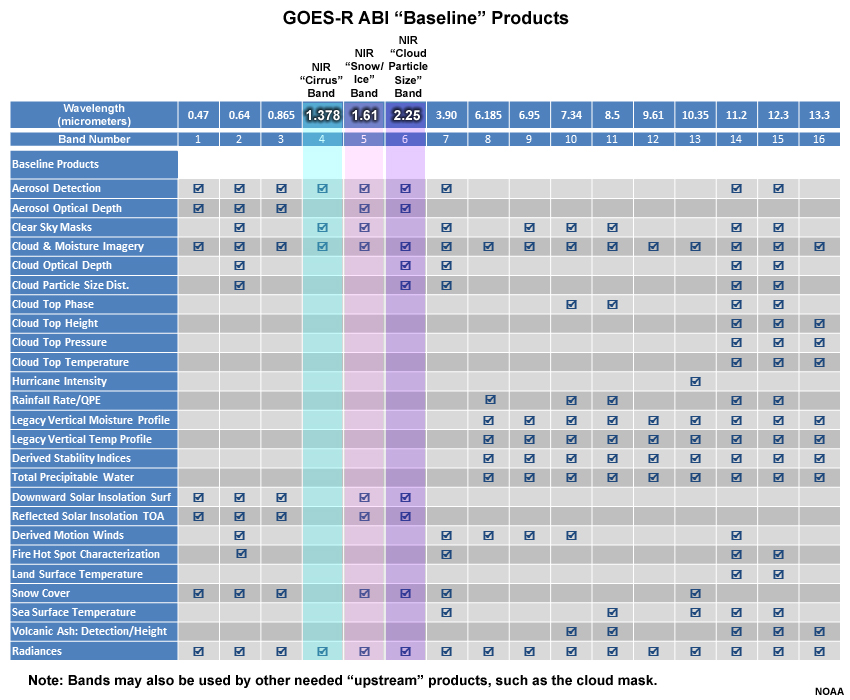
Description:
Table of GOES-R ABI "Baseline" products
File Name:
abi_bands_vs_products_baseline_nir.jpg
Credits:
NOAA
Copyright Terms:
COMET Standard Terms of Use
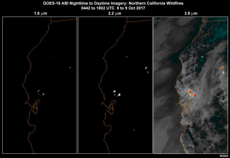
Description:
GOES-16 ABI 1.6, 2.2 and 3.9 micrometer 3-panel animation showing hot spots for several large northern California wildfires on October 8 to 9, 2017
File Name:
abi_fire_nir_swir_g16_ani.mp4
Credits:
NOAA
Copyright Terms:
COMET Standard Terms of Use
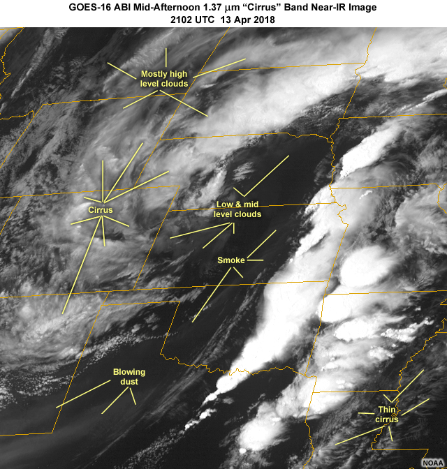
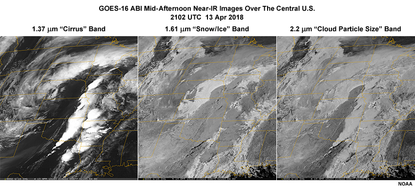
Description:
GOES-16 ABI 1.37 micrometer "cirrus" band image showing a springtime cyclone, trailing cold front, blowing dust and smoke over the central U.S. at 21:02 UTC on April 13, 2018
File Name:
abi_nir_13apr18_1.jpg
Credits:
NOAA
Copyright Terms:
COMET Standard Terms of Use
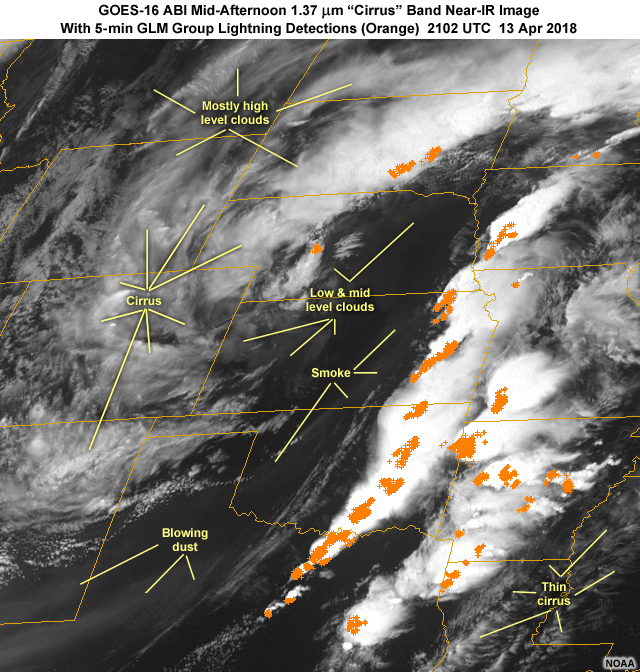
Description:
GOES-16 ABI 1.37 micrometer "cirrus" band image with 5-minute GLM Group lightning detections showing a springtime cyclone, trailing cold front, blowing dust and smoke over the central U.S. at 21:02 UTC on April 13, 2018
File Name:
abi_nir_13apr18_2.jpg
Credits:
NOAA
Copyright Terms:
COMET Standard Terms of Use
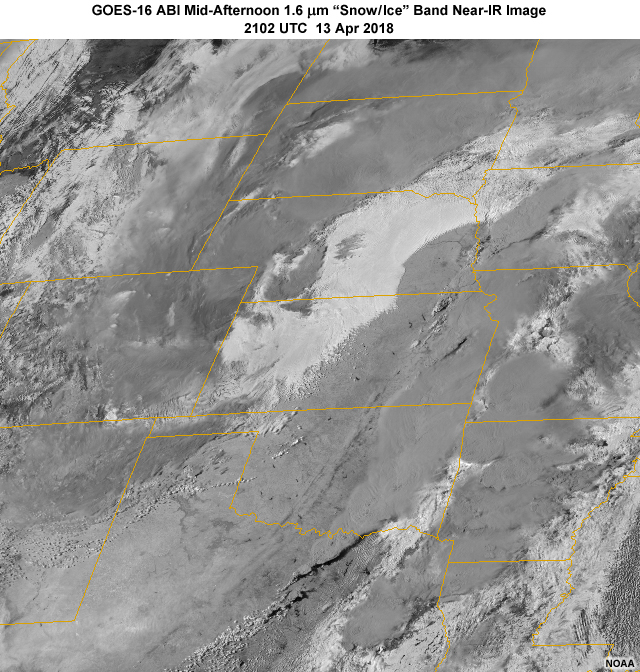
Description:
GOES-16 ABI 1.6 micrometer "snow/ice" band image showing a springtime cyclone, trailing cold front, blowing dust and smoke over the central U.S. at 21:02 UTC on April 13, 2018
File Name:
abi_nir_13apr18_3.jpg
Credits:
NOAA
Copyright Terms:
COMET Standard Terms of Use
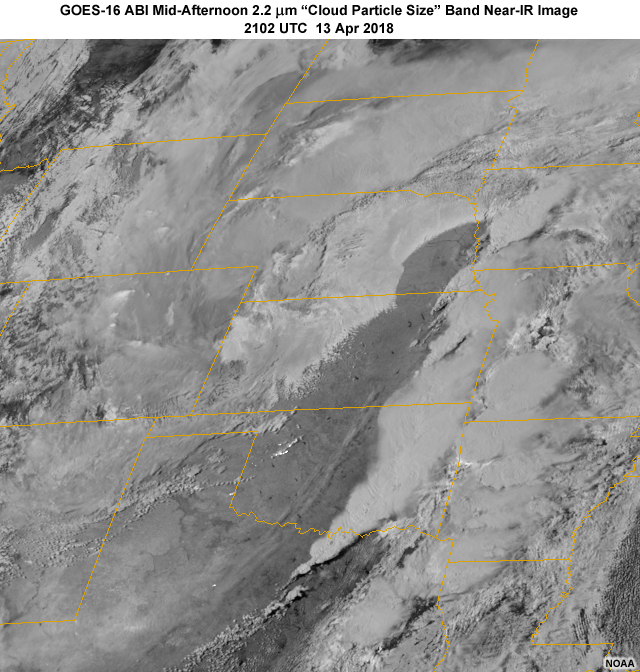
Description:
GOES-16 ABI 2.2 micrometer "cloud particle size" band image showing a springtime cyclone, trailing cold front, blowing dust and smoke over the central U.S. at 21:02 UTC on April 13, 2018
File Name:
abi_nir_13apr18_4.jpg
Credits:
NOAA
Copyright Terms:
COMET Standard Terms of Use
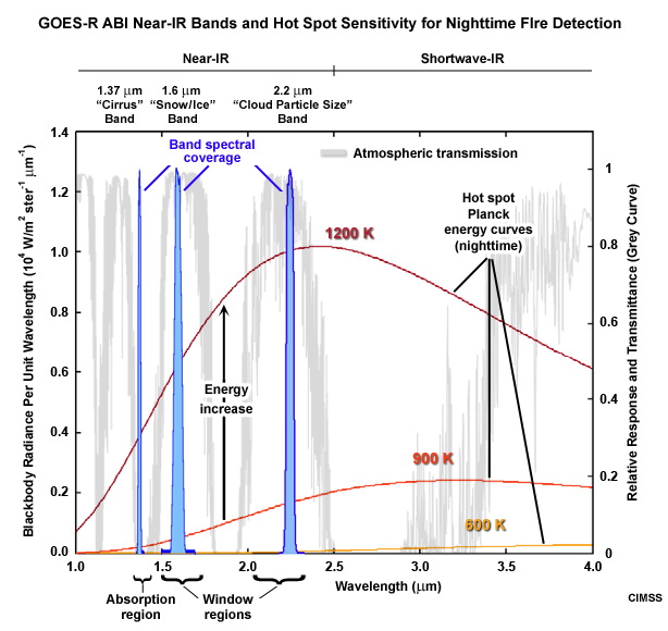
Description:
Plot showing Planck temperature curves for three different hot spot temperatures and the relative sensitivity of GOES-R ABI's 1.6 and 2.2 micrometer near-IR bands.
File Name:
abi_nir_hotspot_detection.jpg
Credits:
CIMSS
Copyright Terms:
COMET Standard Terms of Use
Description:
Three images taken by GOES-16 ABI imager at 1.37, 1.6, and 2.2 micrometers in the near-infrared showing
a passing cyclone, trailing cold front, and blowing dust over southern High Plains region at 20:35 UTC on April 13, 2018
File Name:
abi_nir456_3panel_cldtops_g16.jpg
Credits:
NOAA
Copyright Terms:
COMET Standard Terms of Use
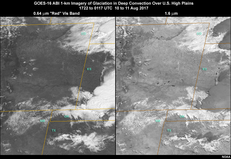
Description:
GOES-16 ABI red band visible and 1.6 micrometer snow/ice band two-panel animation showing glaciation in thunderstorm cloud tops over central and southern high plains region of U.S. on 10 August, 2017
File Name:
abi_nir5_glaciation_g16_ani.mp4
Credits:
NOAA
Copyright Terms:
COMET Standard Terms of Use
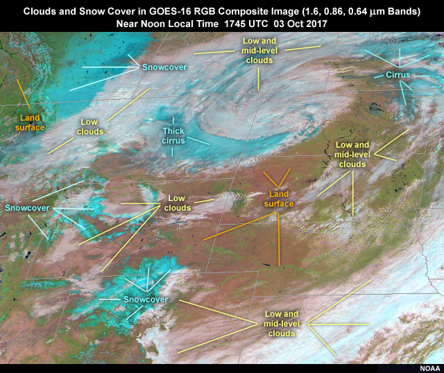
Description:
GOES-16 ABI 1.6, 0.86, 0.64 micrometer band RGB composite image over northern high plains region of U.S. showing a low pressure storm system, clouds, land, and snow cover on October 3, 2017
File Name:
abi_snow_clouds_bands532_rgb_g16.jpg
Credits:
NOAA
Copyright Terms:
COMET Standard Terms of Use
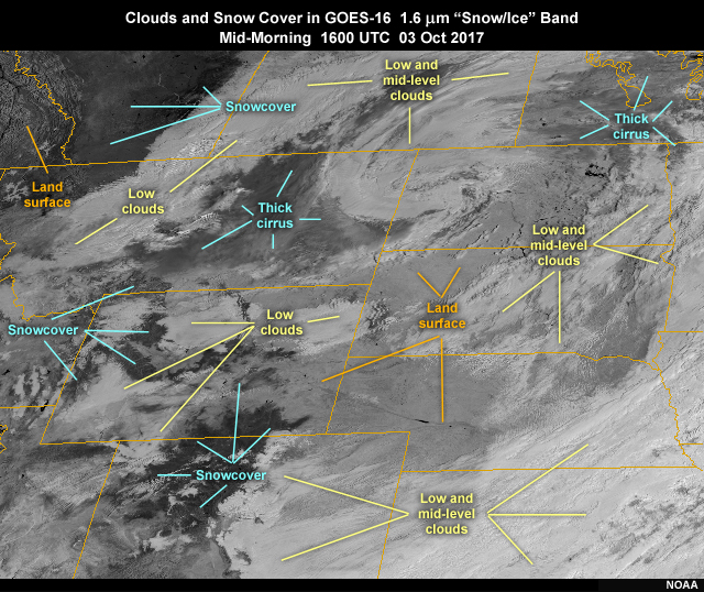
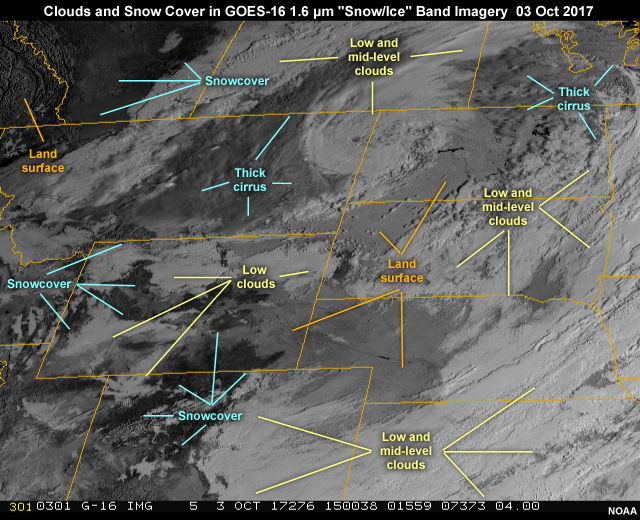
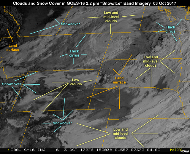
Description:
GOES-16 AHI 1.6 micrometer "snow/ice" band 5 near-infrared image over northern high plains region of U.S. showing a low pressure storm system, clouds, land, and snow cover on October 3, 2017
File Name:
abi_snow_clouds_nir5_annotated_g16.jpg
Credits:
NOAA
Copyright Terms:
COMET Standard Terms of Use
Description:
GOES-16 ABI 1.6 micrometer band-5 near-infrared 15-min animation over northern high plains region of U.S. showing a low pressure storm system, clouds, land, and snow cover on October 3, 2017
File Name:
abi_snow_clouds_nir5_g16_ani.mp4
Credits:
NOAA
Copyright Terms:
COMET Standard Terms of Use
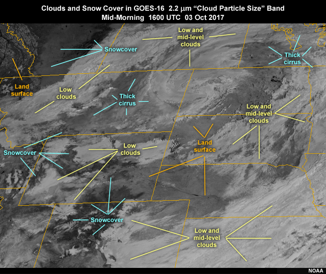
Description:
GOES-16 AHI 2.2 micrometer "cloud particle size" band 6 near-infrared image over northern high plains region of U.S. showing a low pressure storm system, clouds, land, and snow cover on October 3, 2017
File Name:
abi_snow_clouds_nir6_annotated_g16.jpg
Credits:
NOAA
Copyright Terms:
COMET Standard Terms of Use
Description:
GOES-16 ABI 2.2 micrometer band-6 near-infrared 15-min animation over northern high plains region of U.S. showing a low pressure storm system, clouds, land, and snow cover on October 3, 2017
File Name:
abi_snow_clouds_nir6_g16_ani.mp4
Credits:
NOAA
Copyright Terms:
COMET Standard Terms of Use
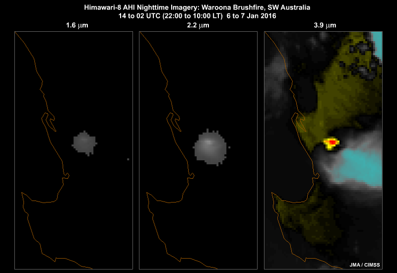
Description:
Himawari-8 AHI 1.6, 2.3 and 3.9 micrometer 3-panel animation showing hot spots for a wildland fire burning in southwest Australia on January 6 to 7, 2016
File Name:
ahi_fire_nir_swir_ani.mp4
Credits:
JMA / CIMSS
Copyright Terms:
COMET Standard Terms of Use
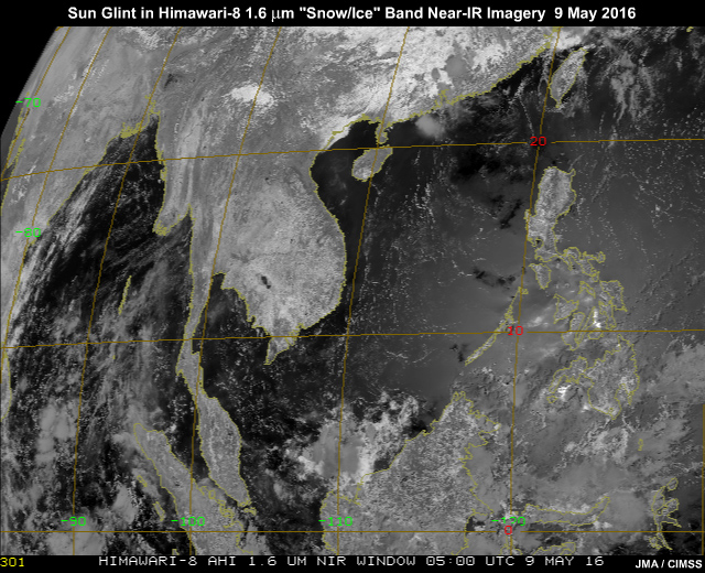
Description:
Sun glint pattern in AHI 1.6 micrometer band-6 near-infrared imagery traveling from east to west across South China Sea and Indian Ocean
File Name:
ahi_glint_nir5_zoom_ani.mp4
Credits:
JMA / CIMSS
Copyright Terms:
COMET Standard Terms of Use
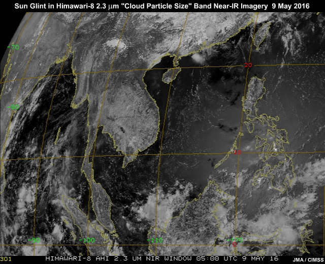
Description:
Sun glint pattern in AHI 2.3 micrometer band-6 near-infrared imagery traveling from east to west across South China Sea and Indian Ocean
File Name:
ahi_glint_nir6_zoom_ani.mp4
Credits:
JMA / CIMSS
Copyright Terms:
COMET Standard Terms of Use
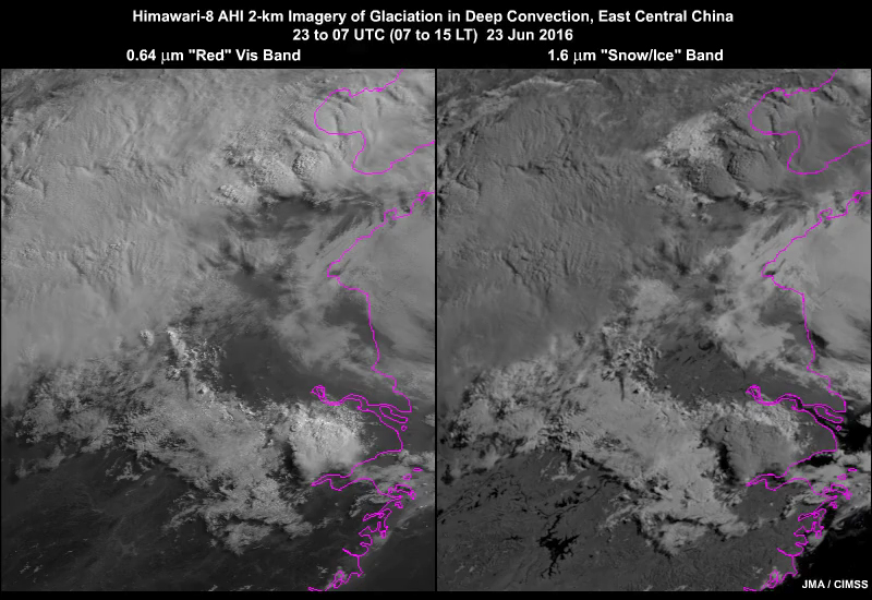
Description:
Himawari-8 AHI red band visible and 1.6 micrometer snow/ice band 2-panel animation showing glaciation in thunderstorm clouds tops during a tornado event in eastern China on 23 June, 2016
File Name:
ahi_nir5_glaciation_ani.mp4
Credits:
JMA / CIMSS
Copyright Terms:
COMET Standard Terms of Use
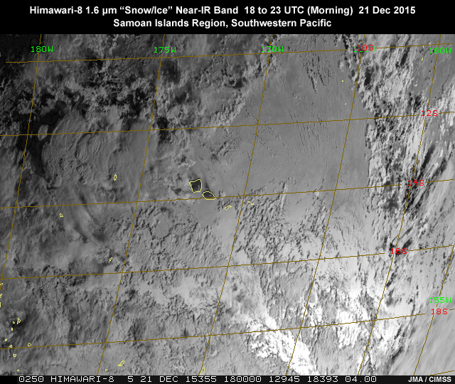
Description:
Sun glint pattern in AHI 1.6 micrometer band 5 near-infrared imagery traveling from east to west across the South Pacific, American Samoa region on December 21, 2015
File Name:
ahi_nir5_glint_21dec15_ani.mp4
Credits:
JMA / CIMSS
Copyright Terms:
COMET Standard Terms of Use
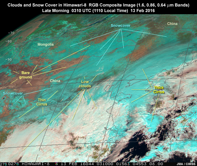
Description:
Himawari-8 AHI 1.6, 0.86, 0.64 micrometer band RGB composite image over East Asia region showing clouds, land, and snow cover on February 13, 2016
File Name:
ahi_snow_clouds_bands543_rgb.jpg
Credits:
JMA / CIMSS
Copyright Terms:
COMET Standard Terms of Use
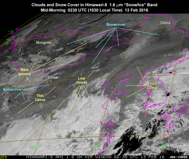
Description:
Himawari-8 AHI 1.6 micrometer band-5 near-IR animation over East Asia region showing clouds, land, and snow cover on February 13, 2016
File Name:
ahi_snow_clouds_nir5_ani.mp4
Credits:
JMA / CIMSS
Copyright Terms:
COMET Standard Terms of Use
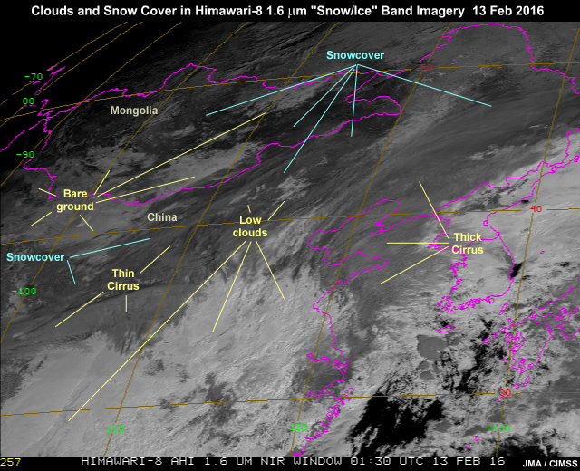
Description:
Himawari-8 AHI 1.6 micrometer "snow/ice" band-5 near-IR image over East Asia region showing clouds, land, and snow cover on February 13, 2016
File Name:
ahi_snow_clouds_nir5_annotated.jpg
Credits:
JMA / CIMSS
Copyright Terms:
COMET Standard Terms of Use
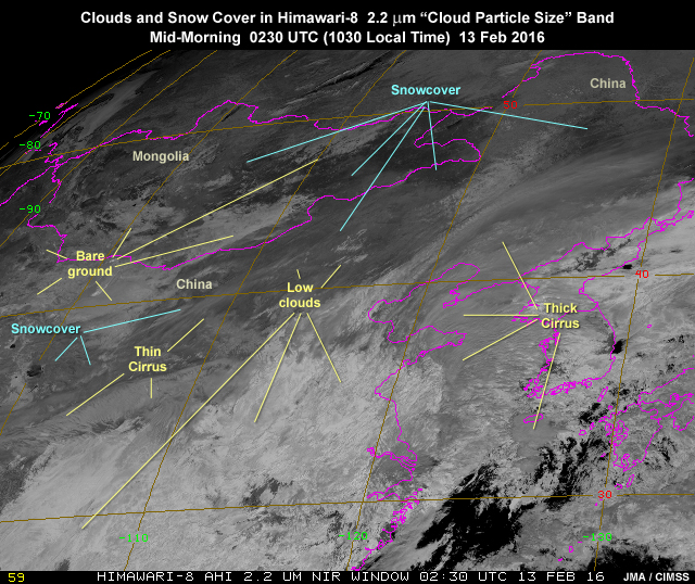
Description:
Himawari-8 AHI 2.3 micrometer band-6 near-IR animation over East Asia region showing clouds, land, and snow cover on February 13, 2016
File Name:
ahi_snow_clouds_nir6_ani.mp4
Credits:
JMA / CIMSS
Copyright Terms:
COMET Standard Terms of Use
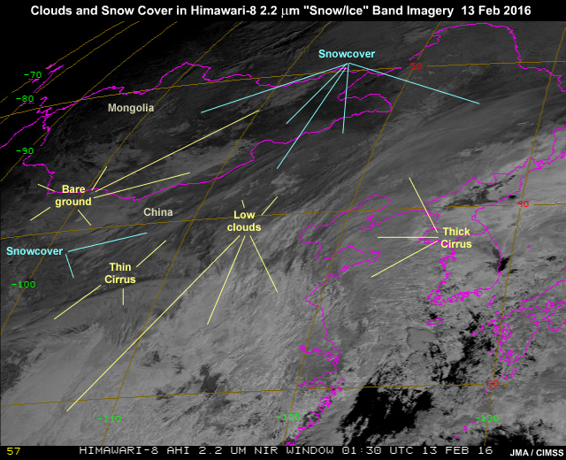
Description:
Himawari-8 AHI 2.3 micrometer "cloud particle size" band-5 near-IR image over East Asia region showing clouds, land, and snow cover on February 13, 2016
File Name:
ahi_snow_clouds_nir6_annotated.jpg
Credits:
JMA / CIMSS
Copyright Terms:
COMET Standard Terms of Use
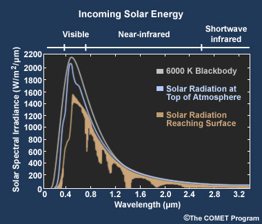
Description:
Plot showing GOES R-U ABI visible and near-infrared channel spectral coverage within the solar emitted radiation spectrum
File Name:
incoming_solar_abi_nir456_bands.jpg
Credits:
�The COMET Program
Copyright Terms:
COMET Standard Terms of Use
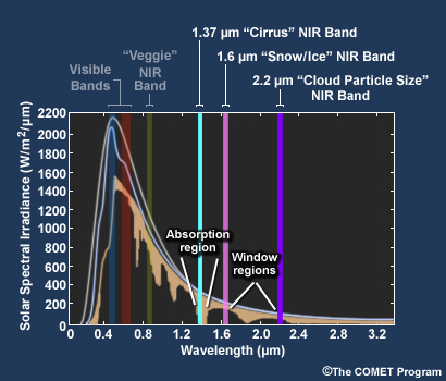
Description:
Plot showing the incoming solar radiation spectrum in the visible and near-infrared and highlighting absorption regions in the near-infrared
File Name:
incoming_solar_abi_vis_nir_abs_spectrum.jpg
Credits:
�The COMET Program
Copyright Terms:
COMET Standard Terms of Use
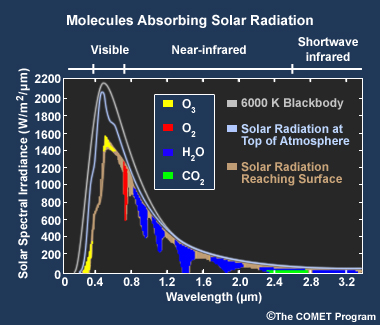
Description:
Plot showing the incoming solar radiation spectrum in the visible and near-infrared
File Name:
incoming_solar_abi_vis_nir_spectrum.jpg
Credits:
�The COMET Program
Copyright Terms:
COMET Standard Terms of Use
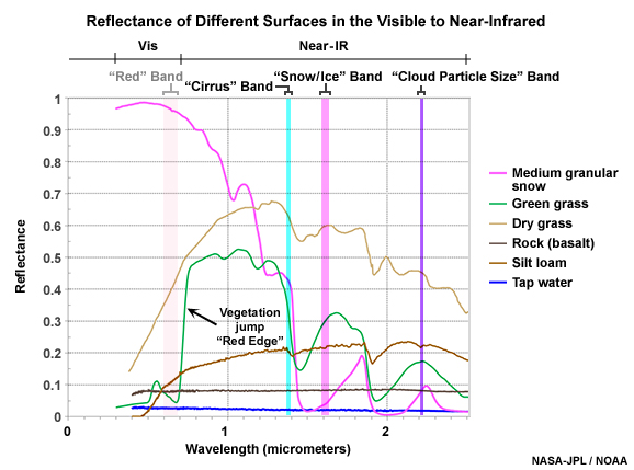
Description:
Reflectance of different surfaces in the near infrared with GOES-R ABI's three near-ir 1.37, 1.6, and 2.2 micrometer bands indicated
File Name:
sfc_snow_cloud_refl_goesr_vis_nir456.jpg
Credits:
NASA-JPL / NOAA
Copyright Terms:
COMET Standard Terms of Use
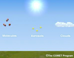
Description:
Animation of incoming solar radiation reflecting off Earth's surface and scattered by atmospheric molecules, aerosols, and clouds
File Name:
sm2cm5_ani.mp4
Credits:
�The COMET Program
Copyright Terms:
COMET Standard Terms of Use
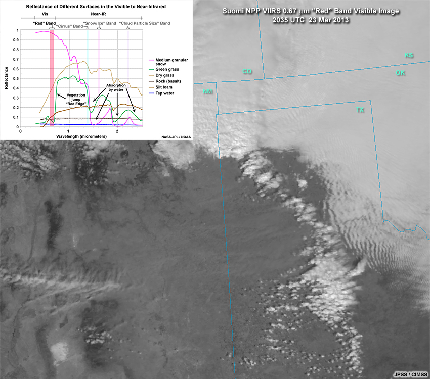
Description:
Suomi NPP VIIRS 0.67 micrometer "red" band image showing a passing cyclone, trailing cold front, and blowing dust over southern High Plains region at 20:35 UTC on March 23, 2013 with near-IR spectra plot overlay
File Name:
viirs_m05_red_band_refl_plot.jpg
Credits:
JPSS / CIMSS
Copyright Terms:
COMET Standard Terms of Use
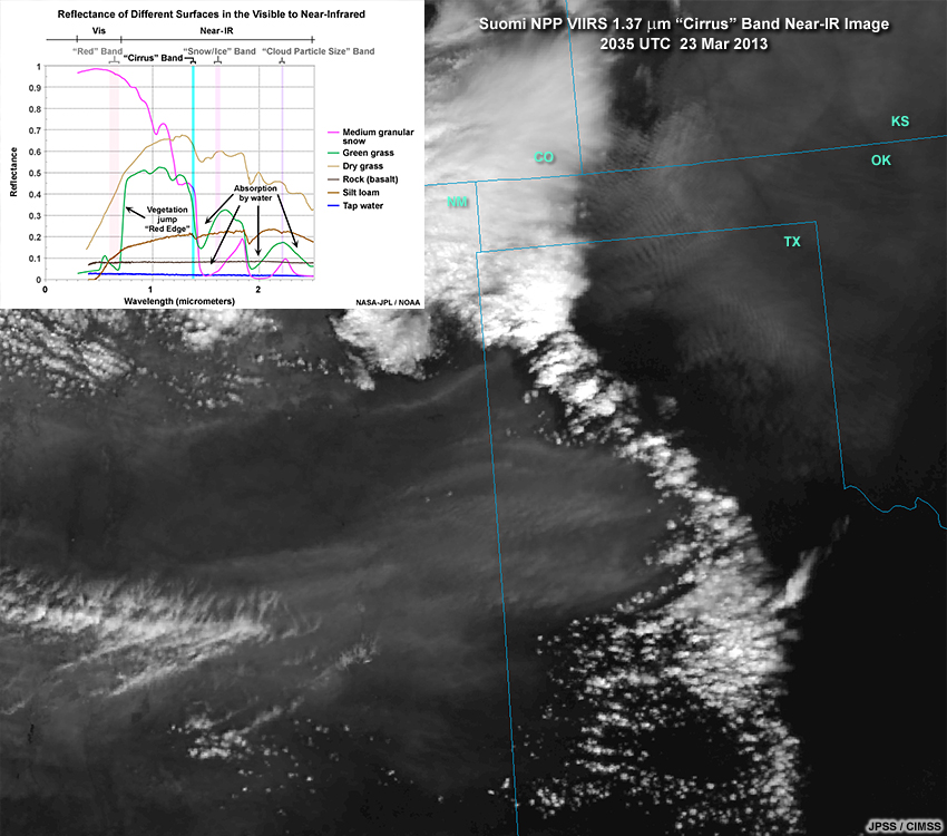
Description:
Suomi NPP VIIRS 1.37 micrometer "cirrus" band image showing a passing cyclone, trailing cold front, and blowing dust over southern High Plains region at 20:35 UTC on March 23, 2013 with near-IR spectra plot overlay
File Name:
viirs_m09_cirrus_band_refl_plot.jpg
Credits:
JPSS / CIMSS
Copyright Terms:
COMET Standard Terms of Use
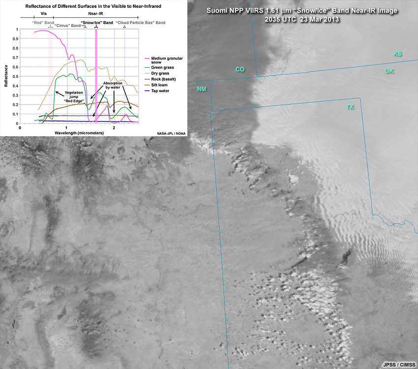
Description:
Suomi NPP VIIRS 1.61 micrometer "snow/ice" band image showing a passing cyclone, trailing cold front, and blowing dust over southern High Plains region at 20:35 UTC on March 23, 2013 with near-IR spectra plot overlay
File Name:
viirs_m10_snowice_band_refl_plot.jpg
Credits:
JPSS / CIMSS
Copyright Terms:
COMET Standard Terms of Use
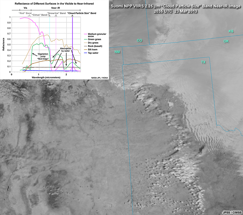
Description:
Suomi NPP VIIRS 1.61 micrometer "snow/ice" band image showing a passing cyclone, trailing cold front, and blowing dust over southern High Plains region at 20:35 UTC on March 23, 2013 with near-IR spectra plot overlay
File Name:
viirs_m11_cldpartsize_band_refl_plot.jpg
Credits:
JPSS / CIMSS
Copyright Terms:
COMET Standard Terms of Use
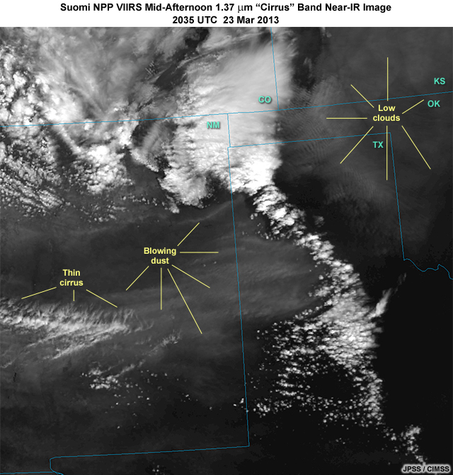
Description:
Suomi NPP VIIRS 1.37 micrometer "cirrus" band image showing a passing cyclone, trailing cold front, and blowing dust over U.S. southern High Plains region at 20:35 UTC on March 23, 2013
File Name:
viirs_nir_23mar13_1.jpg
Credits:
JPSS / CIMSS
Copyright Terms:
COMET Standard Terms of Use
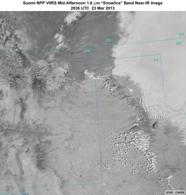
Description:
Suomi NPP VIIRS 1.6 micrometer "snow/ice" band image showing a passing cyclone, trailing cold front, and blowing dust over U.S. southern High Plains region at 20:35 UTC on March 23, 2013
File Name:
viirs_nir_23mar13_2.jpg
Credits:
JPSS / CIMSS
Copyright Terms:
COMET Standard Terms of Use
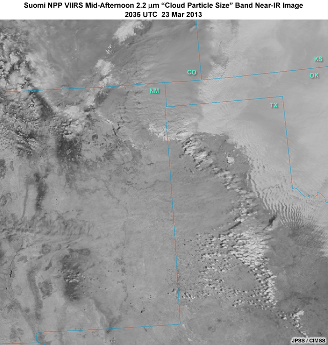
Description:
Suomi NPP VIIRS 2.2 micrometer "cloud particle size" band image showing a passing cyclone, trailing cold front, and blowing dust over U.S. southern High Plains region at 20:35 UTC on March 23, 2013
File Name:
viirs_nir_23mar13_3.jpg
Credits:
JPSS / CIMSS
Copyright Terms:
COMET Standard Terms of Use
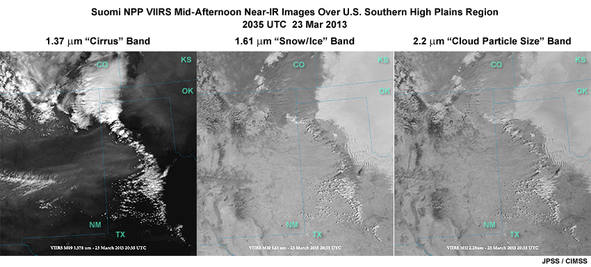
Description:
Three images taken by Suomi NPP VIIRS imager at 1.37, 1.6, and 2.2 micrometers in the near-infrared showing a passing cyclone, trailing cold front, and blowing dust over southern High Plains region at 20:35 UTC on March 23, 2013
File Name:
viirs_nir456_3panel_cldtops.jpg
Credits:
JPSS / CIMSS
Copyright Terms:
COMET Standard Terms of Use