Media Gallery
Media elements used in this module are protected by a variety of copyright licenses. Please use the "copyright terms" link associated with each item below for more information.
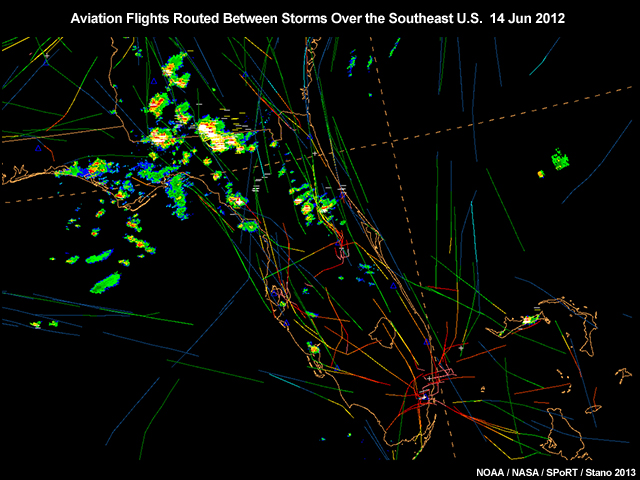
Description:
A plot of aircraft tracks over the Southeast U.S. showing the use of lightning detection data in aviation routing for June 14, 2012.
File Name:
air_traffic_routing_between_storms.jpg
Credits:
NOAA/NASA/SPoRT/Stano 2013
Copyright Terms:
COMET Standard Terms of Use
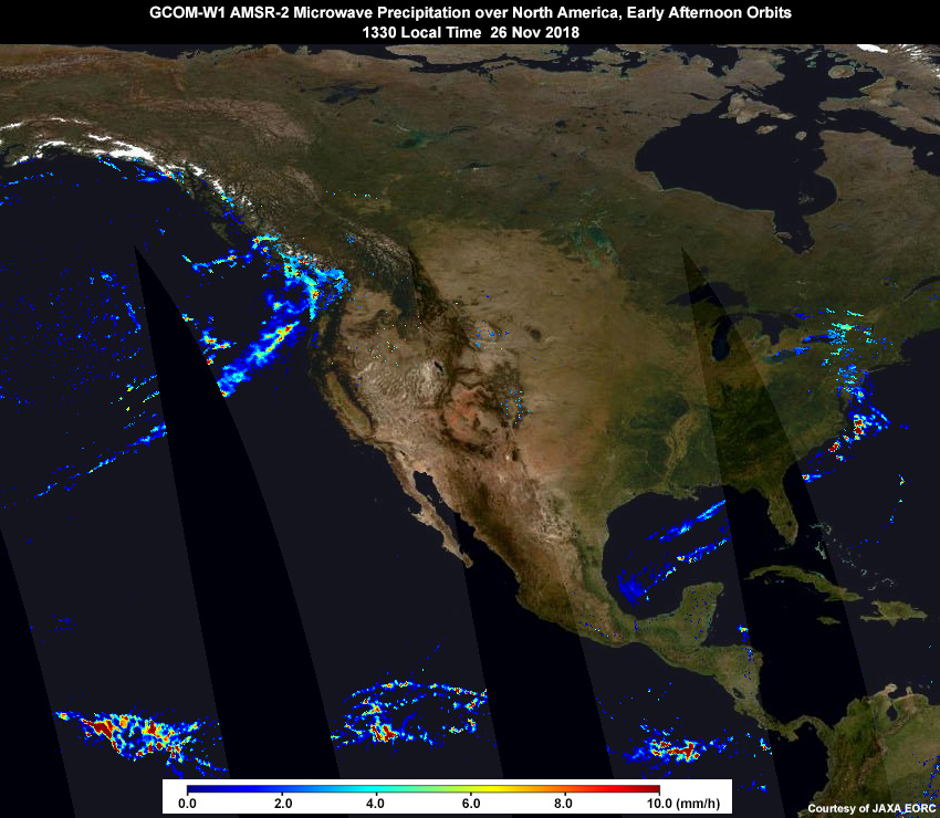
Description:
GCOM-2 AMSR-2 microwave precipitation rate composite of early afternoon (local time) ascending orbits over North America on November 26, 2018
File Name:
amsr2_precip_asc_26nov18.jpg
Credits:
Courtesy of JAXA EORC
Copyright Terms:
COMET Standard Terms of Use
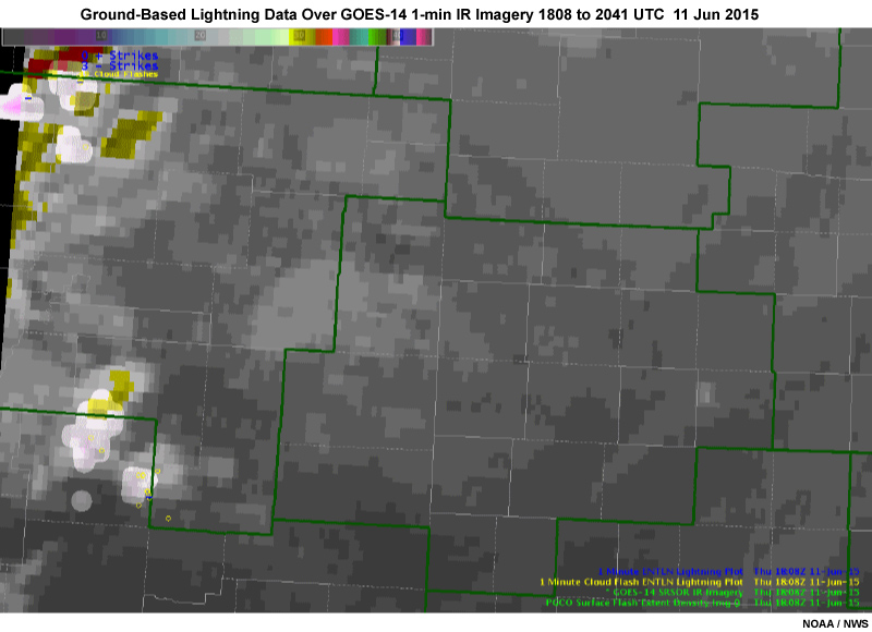
Description:
GOES-14 1-minute rapid scan IR imagery with ground-based lightning information overlaid over central Plains on June 11, 2015.
File Name:
g14_1min_ir_ltg_ani.mp4
Credits:
NOAA / NWS
Copyright Terms:
COMET Standard Terms of Use
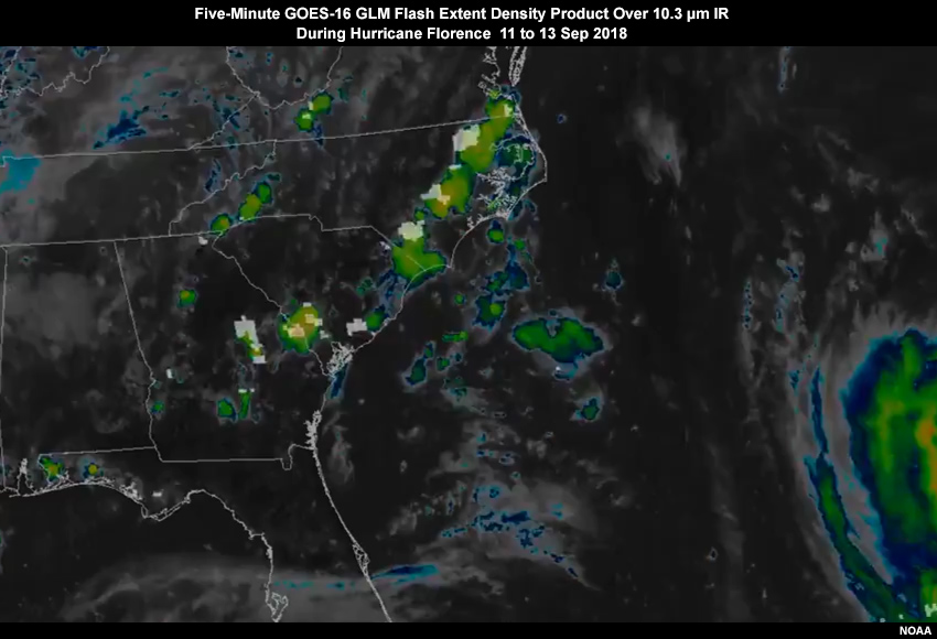
Description:
Five-minute animation of GOES-16 GLM lightning Flash Extent Density product over 10.3 micrometer IR imagery as hurricane Florence approaches the U.S. East Coast from 11 to 13 September, 2018
File Name:
g16_glm_hurr_florence_sep18_ani.mp4
Credits:
NOAA
Copyright Terms:
COMET Standard Terms of Use
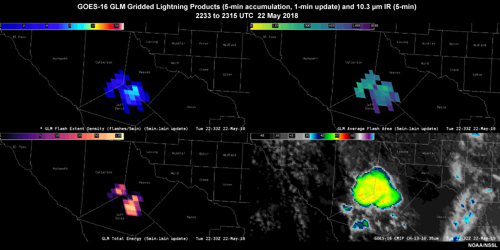
Description:
GOES-16 1-minute rapid scan IR imagery with ground-based lightning information overlaid over central Plains on June 11, 2015.
File Name:
g16_ltg_ir_22may18_ani.mp4
Credits:
NOAA/NSSL
Copyright Terms:
COMET Standard Terms of Use
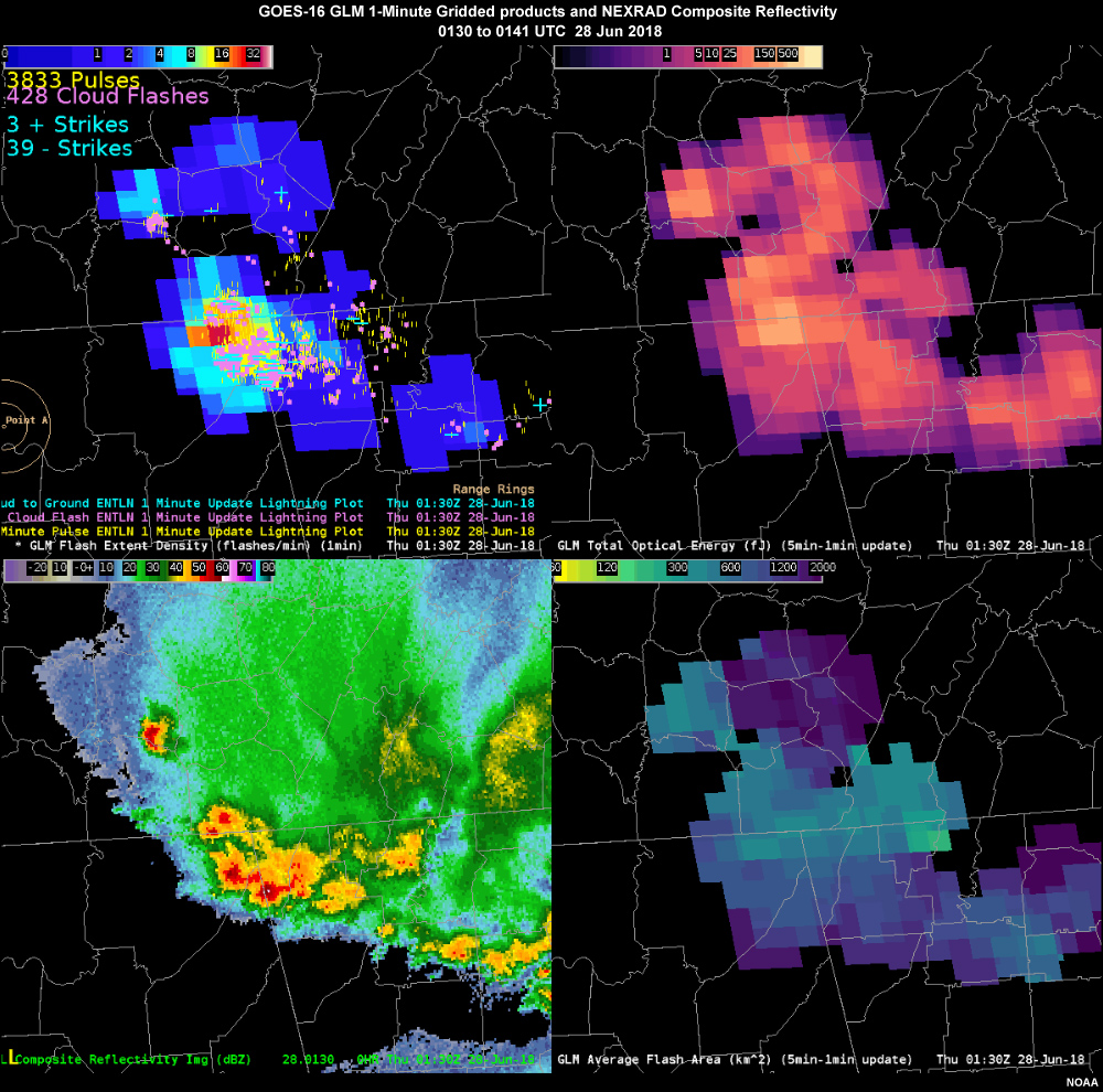
Description:
Animation of GOES-16 GLM flash extent density, total optical energy, and average flash area gridded products and composite reflectivity showing a large thunderstorm complex over the southeast U.S. on June 28, 2018
File Name:
glm_anvil_ltg_28jun18_g16_ani.mp4
Credits:
NOAA
Copyright Terms:
COMET Standard Terms of Use
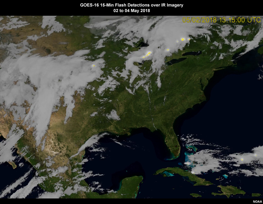
Description:
Animation of 15-minute GOES-16 GLM lightning Flash Extent Density product over IR imagery over CONUS from May 2 to 4, 2018
File Name:
glm_conus_02may18_g16_ani.mp4
Credits:
NOAA
Copyright Terms:
COMET Standard Terms of Use
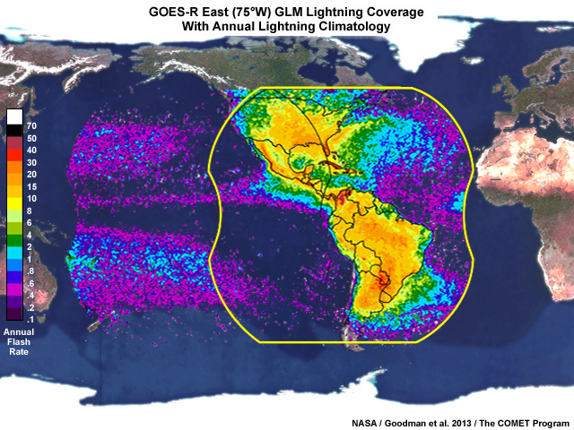
Description:
Geostationary Lightning Mapper overage from a GOES-East satellite position at 75 degrees west longitude
File Name:
glm_coverage_goes_east.jpg
Credits:
NASA / Goodman et al. 2013 / The COMET Program
Copyright Terms:
COMET Standard Terms of Use
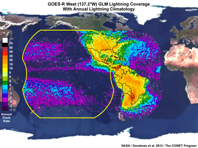
Description:
Geostationary Lightning Mapper overage from a GOES-West position at 137 degrees west longitude
File Name:
glm_coverage_goes_west.jpg
Credits:
NASA / Goodman et al. 2013 / The COMET Program
Copyright Terms:
COMET Standard Terms of Use
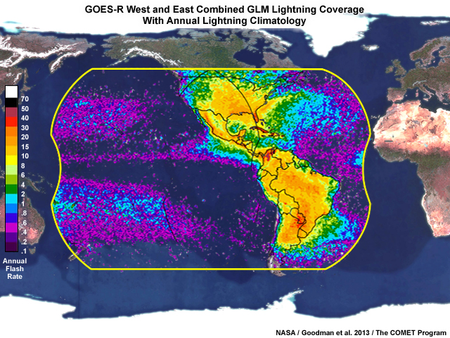
Description:
Geostationary Lightning Mapper combined coverage from GOES-West and GOES-East satellite locations
File Name:
glm_coverage_goes_west_east_combined.jpg
Credits:
NASA / Goodman et al. 2013 / The COMET Program
Copyright Terms:
COMET Standard Terms of Use
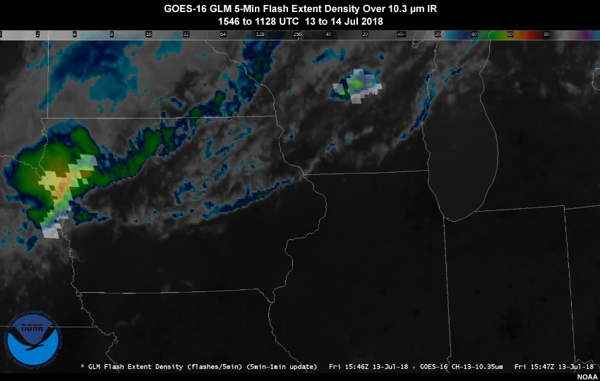
Description:
Animation of the GOES-16 GLM 5-minute (1-min update) lightning Flash Extent Density product over 10.3 micrometer IR imagery showing daytime convection developing over portions of the Upper Midwest on July 13, 2018
File Name:
glm_fed_ir_13jul18_g16_ani.mp4
Credits:
NOAA
Copyright Terms:
COMET Standard Terms of Use
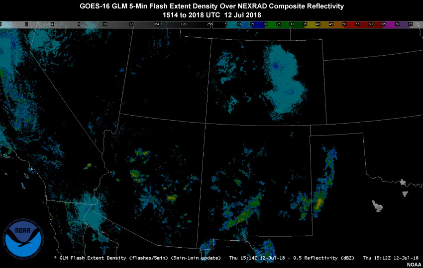
Description:
Animation of the GOES-16 GLM 5-min (with 1-minute update) Flash Extent Density product over NEXRAD composite reflectivity showing daytime convection over the southweat U.S. on 12 July, 2018
File Name:
glm_fed_radar_12jul18_g16_ani.mp4
Credits:
NOAA
Copyright Terms:
COMET Standard Terms of Use
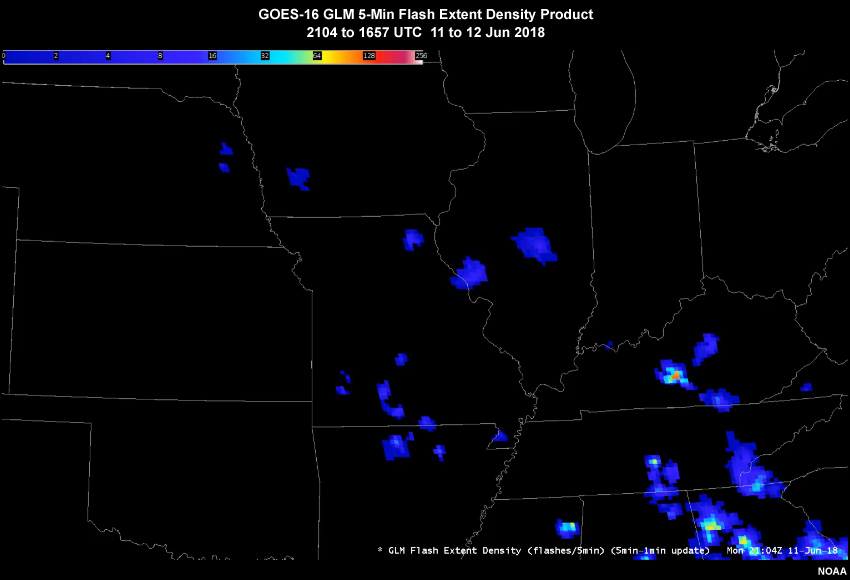
Description:
Animation of the GOES-16 GLM 5-min (1-min update) lightning Flash Extent Density product showing daytime convection over the central U.S. on June 11 and 12, 2018
File Name:
glm_fedonly_11jun18_g16_ani.mp4
Credits:
NOAA
Copyright Terms:
COMET Standard Terms of Use
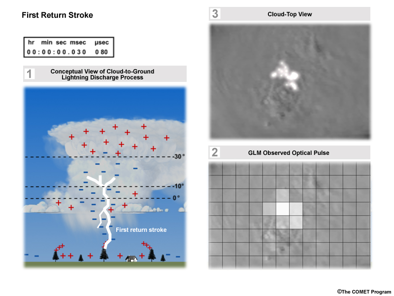
Description:
3-panel representation of a cloud-to-ground lightning strike, optical pulses from above the cloud top generated by that strike, and a simulated GLM detection of the cloud top optical pulses at 8-km resolution.
File Name:
glm_grid1.jpg
Credits:
©The COMET Program
Copyright Terms:
COMET Standard Terms of Use

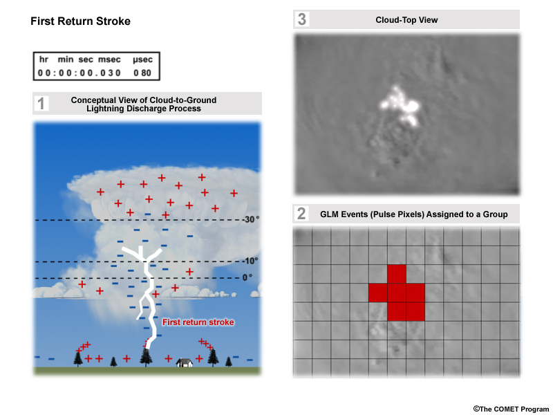
Description:
3-panel representation of a cloud-to-ground lightning strike, optical pulses from above the cloud top generated by that strike, and a simulated GLM detection of the cloud top optical pulses at 8-km resolution.
File Name:
glm_grid2.jpg
Credits:
©The COMET Program
Copyright Terms:
COMET Standard Terms of Use
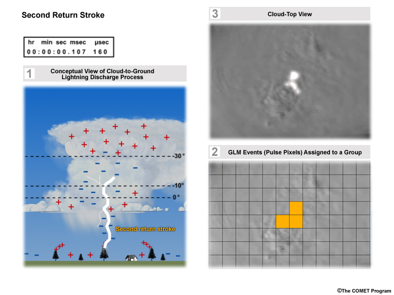
Description:
3-panel representation of a cloud-to-ground lightning strike, optical pulses from above the cloud top generated by that strike, and a simulated GLM detection of the cloud top optical pulses at 8-km resolution showing pulses aggregated into one group.
File Name:
glm_grid3.jpg
Credits:
©The COMET Program
Copyright Terms:
COMET Standard Terms of Use
Description:
3-panel representation of a cloud-to-ground lightning strike, optical pulses from above the cloud top generated by that strike, and a simulated GLM detection of the cloud top optical pulses at 8-km resolution showing pulses aggregated into one group.
File Name:
glm_grid4.jpg
Credits:
©The COMET Program
Copyright Terms:
COMET Standard Terms of Use
Description:
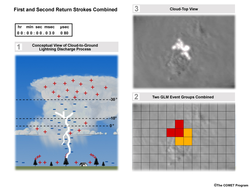
3-panel representation of a cloud-to-ground lightning strike, optical pulses from above the cloud top generated by that strike, and a simulated GLM detection of the cloud top optical pulses at 8-km resolution showing two pulse (event) groups from two return strokes (during one lightning strike) assigned to one group.
File Name:
glm_grid5.jpg
Credits:
©The COMET Program
Copyright Terms:
COMET Standard Terms of Use
Description:
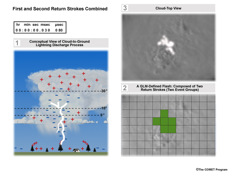
3-panel representation of a cloud-to-ground lightning strike, optical pulses from above the cloud top generated by that strike, and a simulated GLM detection of the cloud top optical pulses at 8-km resolution showing two pulse (event) groups from two return strokes (during one lightning strike) assigned to one group.
File Name:
glm_grid6.jpg
Credits:
©The COMET Program
Copyright Terms:
COMET Standard Terms of Use
Description:
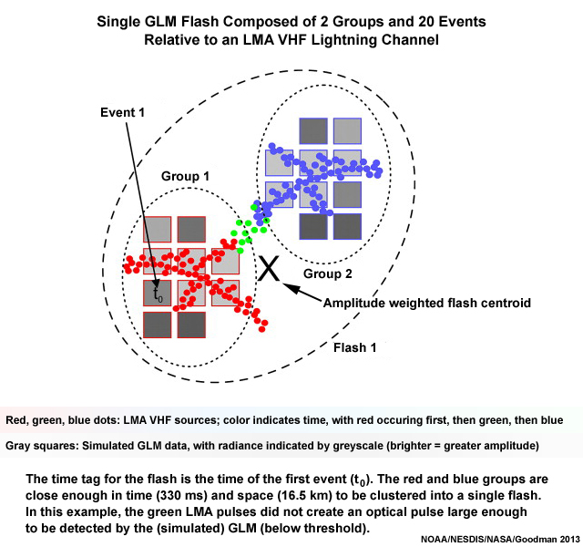
Illustration of a single GLM flash composed of 2 groups and 20 events relative to a LMA VHF lightning channel
File Name:
GLM_single_flash_depiction_Goodman_2013.jpg
Credits:
NOAA/NESDIS/NASA/Goodman et al. 2013
Copyright Terms:
COMET Standard Terms of Use
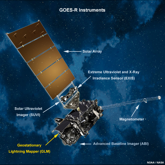
Description:
Picture of GOES-R and its instruments in space
File Name:
goes_r_instruments.jpg
Credits:
NOAA/NASA
Copyright Terms:
COMET Standard Terms of Use
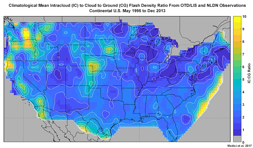
Description:
Plot showing intracloud vs. cloud to ground lightning activity over the U.S. from combined polar-orbiting OTD and LIS 18.5-year flash density observations taken from May 1995 to December 2013
File Name:
ic_to_cg_ltg_ratio_us_2017.jpg
Credits:
Medici et al. 2017
Copyright Terms:
COMET Standard Terms of Use
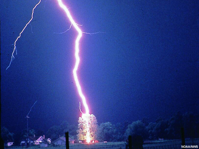
Description:
Photo of nighttime cloud-to-ground lightning strike hitting a tree.
File Name:
lightning_hits_tree_NWS_ERH.jpg
Credits:
NOAA/NWS
Copyright Terms:
Creative Commons Attribution-Noncommercial-Share Alike 2.0 Generic
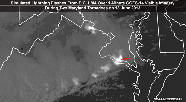
Description:
Animation showing simulated GLM lightning flashes from ground-based Washington, D.C. LMA (Lightning Mapping Array) data over GOES-14 1-minute imagery during two tornadoes in Maryland on 13 June 2013.
File Name:
LightningTornado_short_ani_13jun2013.mp4
Credits:
NOAA/NESDIS/STAR
Copyright Terms:
COMET Standard Terms of Use
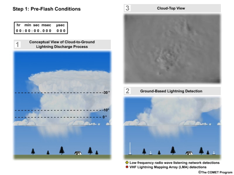
Description:
A three-panel animation showing the evolution of an average thunderstorm cloud-to-ground lightning strike with one panel showing a conceptual model, a second panel showing lightning as observed by both UHF and VHF radio detection systems, and a third panel showing optical pulses from above the cloud top.
File Name:
ltg_ani_narrated.mp4
Credits:
©The COMET Program
Copyright Terms:
COMET Standard Terms of Use
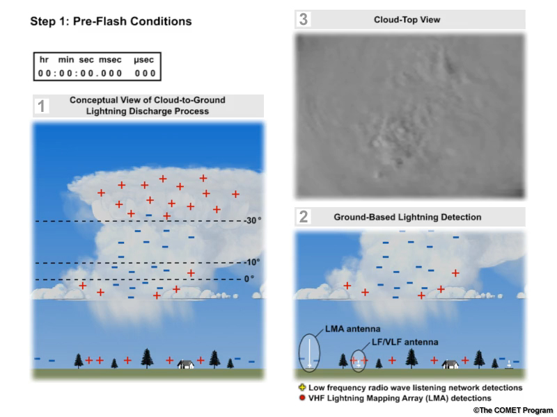
Description:
The first frame in a three-panel animation showing the evolution of an average thunderstorm cloud-to-ground lightning strike with one panel showing a conceptual model, a second panel showing lightning as observed by both VHF and LF/VLF radio detection systems, and a third panel showing optical pulses from above the cloud top.
File Name:
ltg_ani_still.jpg
Credits:
©The COMET Program
Copyright Terms:
COMET Standard Terms of Use
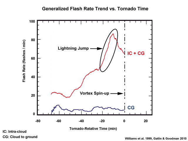
Description:
Plot showing the generalized flash rate trend vs. tornado time
File Name:
ltg_jump_annotated.jpg
Credits:
Williams et al. 1999, Gatlin and Goodman 2010
Copyright Terms:
COMET Standard Terms of Use
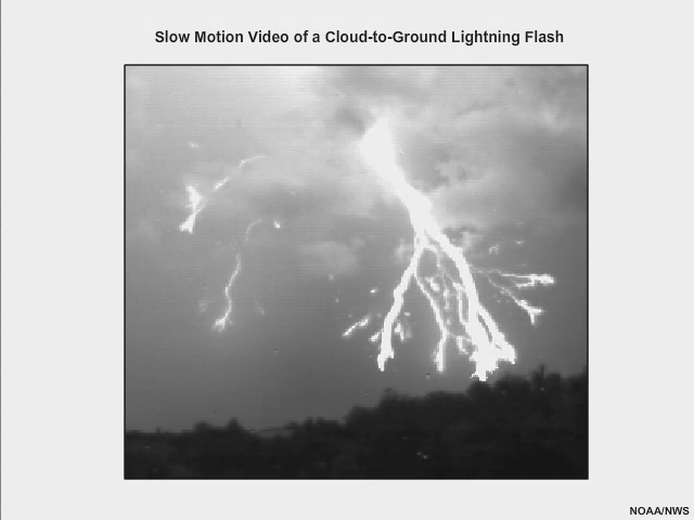
Description:
High speed video (shown in slow motion) showing the life cycle of a cloud-to-ground lightning flash with a single return stroke filmed at 4000 frames per second.
File Name:
ltg_stepped_leader_return_stroke.mp4
Credits:
NOAA/NWS
Copyright Terms:
COMET Standard Terms of Use
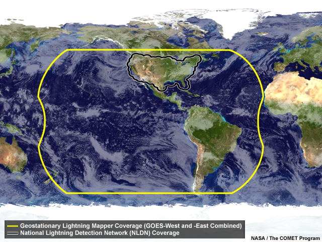
Description:
United States National Lightning Detection Network coverage on the globe with satellite image of thunderstorms and other clouds.
File Name:
nldn_glm_coverage.jpg
Credits:
NASA / The COMET Program
Copyright Terms:
COMET Standard Terms of Use
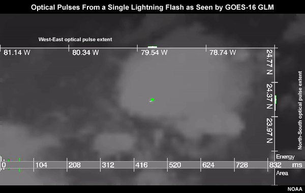
Description:
Animation showing the energy and area evolution of optical pulses from a single lightning flash as detected by the GOES-16 GLM
File Name:
sample_glmflash_g16_ani.mp4
Credits:
NOAA
Copyright Terms:
COMET Standard Terms of Use
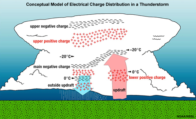
Description:
Conceptual model showing the electrical charge distribution inside deep convection (thunderstorms), developed by NSSL and university scientists.
File Name:
tstm_lightning_structure.jpg
Credits:
NOAA/NSSL
Copyright Terms:
COMET Standard Terms of Use

Description:
Animation of GOES-16 GLM Fire Radiative Power product over 0.64 µm visible imagery showing fires breaking out over Washington state on August 11 to 12, 2018
File Name:
wa_fires_and_vis_g16_ani.mp4
Credits:
NOAA
Copyright Terms:
COMET Standard Terms of Use
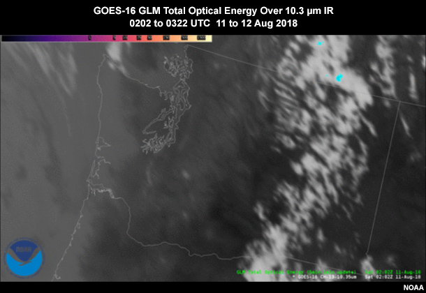
Description:
Animation of GOES-16 GLM Total Optical Energy (5-minute) over 10.3 micrometer IR imagery showing lightning activity over Washington state on August 11 to 12, 2018
File Name:
wa_glm_and_ir_g16_ani.mp4
Credits:
NOAA
Copyright Terms:
COMET Standard Terms of Use