Media elements used in this module are protected by a variety of copyright licenses. Please use the "copyright terms" link associated with each item below for more information.
Description:
UnRestricted Mesoscale Analysis of the area around Big Sur, CA.
File Name:
bigsur_analysis.jpg
Credits:
NOAA/NWS/MTR
Copyright Terms:
COMET Standard Terms of Use
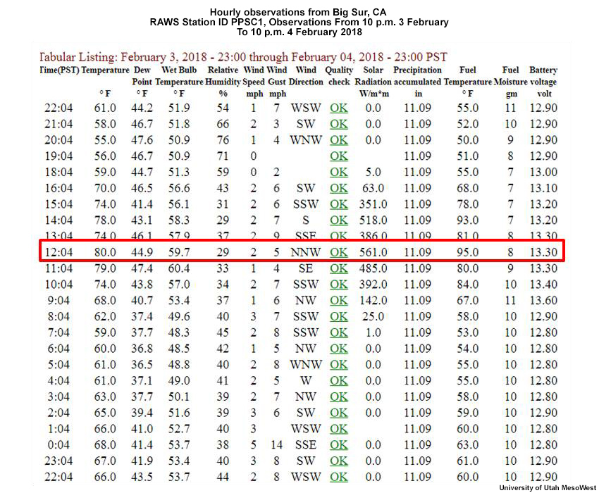
Description:
MesoWest observations from Big Sur, CA for 3 February 2018, 22:04 p.m. to 4 February 2018, 22:04 p.m. Pacific Standard Time.
File Name:
BigSur_data_020418.jpg
Credits:
University of Utah MesoWest
Copyright Terms:
COMET Standard Terms of Use
Description:
Observations from the area around Big Sur, CA.
File Name:
bigsur_observations.jpg
Credits:
NOAA/NWS/MTR
Copyright Terms:
COMET Standard Terms of Use
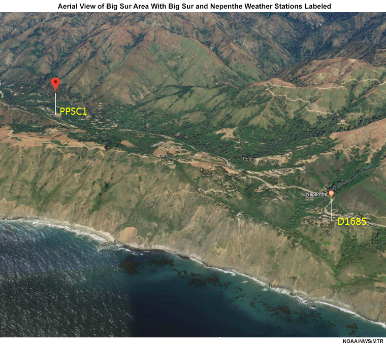
Description:
Aerial view of Big Sur area with Big Sur and Nepenthe weather stations labeled.
File Name:
BigSur_unresolvedterrain_marinelyr_tmpbias.jpg
Credits:
NOAA/NWS/MTR
Copyright Terms:
COMET Standard Terms of Use
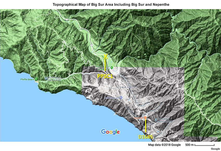
Description:
Topographic map of Big Sur area with Big Sur and Nepenthe weather stations labeled.
File Name:
BigSurTopo.jpg
Credits:
Google
Copyright Terms:
COMET Standard Terms of Use
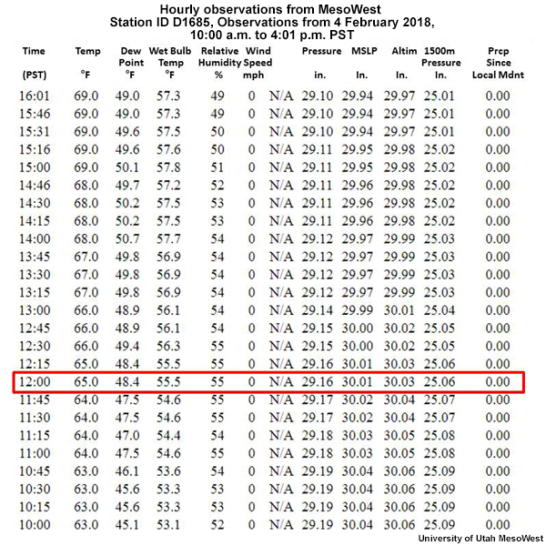
Description:
Hourly observations from MesoWest ID D1685, Big Sur, CA for 4 February 2018, 10:00 a.m. to 4:01 p.m.
File Name:
D1685_data_020418.jpg
Credits:
University of Utah MesoWest
Copyright Terms:
COMET Standard Terms of Use
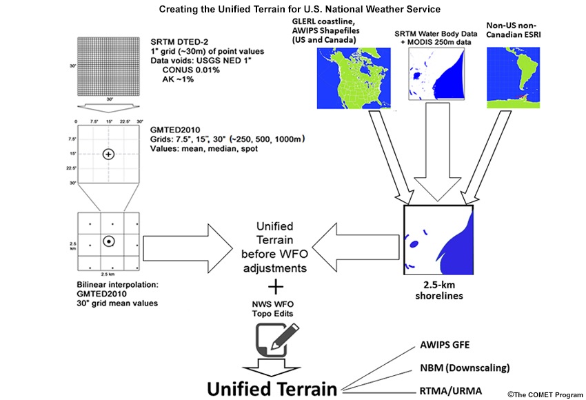
Description:
Developing Unified Terrain Flow Chart
File Name:
flowchart_UT.jpg
Credits:
©The COMET Program
Copyright Terms:
COMET Standard Terms of Use
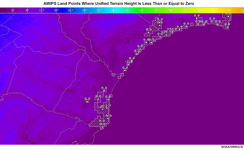
Description:
Land-designated points in AWIPS where unified terrain height is zero or less
File Name:
GMTED_level_0_where_land_is_SC.jpg
Credits:
NOAA/NWS/ILM
Copyright Terms:
COMET Standard Terms of Use
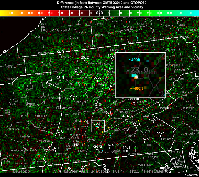
Description:
Difference in elevation between Global Multi-resolution Terrain Elevation Data 2010 and Global Topography in feet in the State College PA County Warning Area Vicinity.
File Name:
GMTEDminusGTOPO_500ft_CentPA.jpg
Credits:
NOAA/NWS
Copyright Terms:
COMET Standard Terms of Use
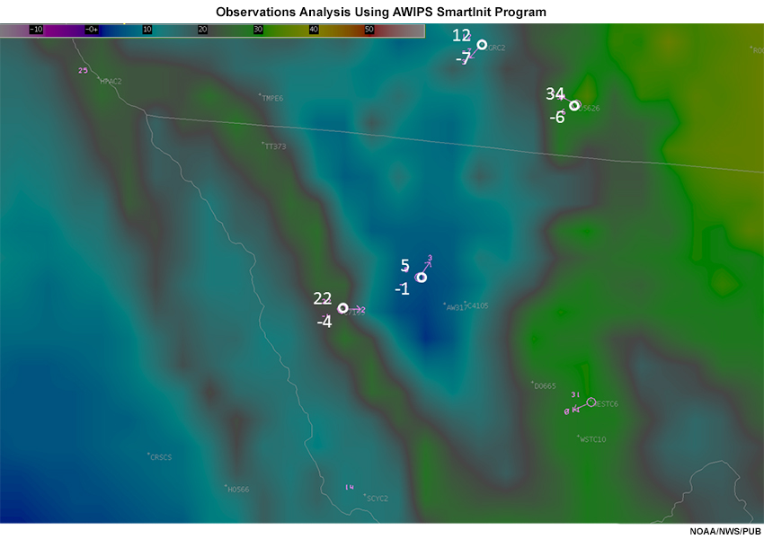
Description:
Observations Analysis Using AWIPS SmartInit Program
File Name:
Obscoldpoolerror_NM.jpg
Credits:
NOAA/NWS/PUB
Copyright Terms:
COMET Standard Terms of Use
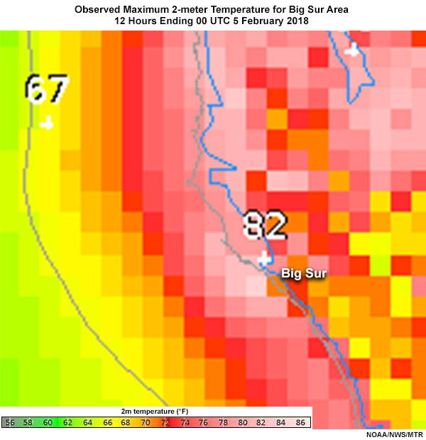
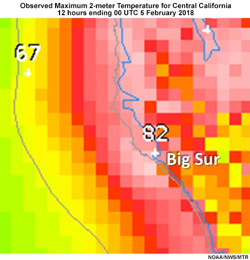
Description:
Observed maximum 2-meter temperature for central California, 12 hours ending 00 UTC 5 February 2018
File Name:
ObsSmInit_Tmax4Feb2018_BigSur.jpg
Credits:
NOAA/NWS/MTR
Copyright Terms:
COMET Standard Terms of Use
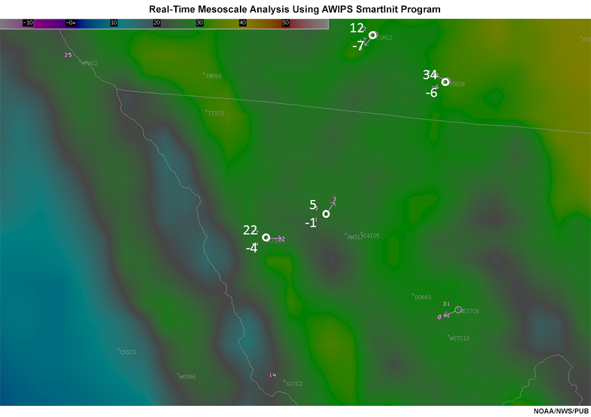
Description:
Real-Time Mesoscale Analysis Using AWIPS SmartInit Program
File Name:
RTMAcoldpoolerror_NM.jpg
Credits:
NOAA/NWS/PUB
Copyright Terms:
COMET Standard Terms of Use
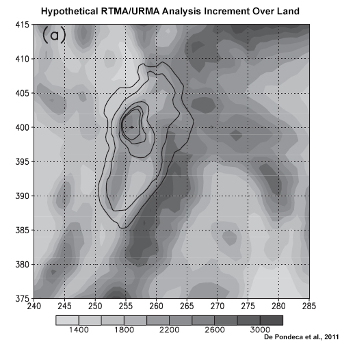
Description:
Hypothetical Real-Time Mesoscale Analysis Spread of Analysis Increments Over Land
File Name:
T2m_errorcov.jpg
Credits:
De Pondeca et al., 2011
Copyright Terms:
COMET Standard Terms of Use
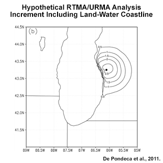
Description:
Hypothetical Real-Time Mesoscale Analysis Spread of Analysis Increments at a Land-Water Coastline
File Name:
T2m_errorcov_land-water.jpg
Credits:
De Pondeca et al., 2011
Copyright Terms:
COMET Standard Terms of Use
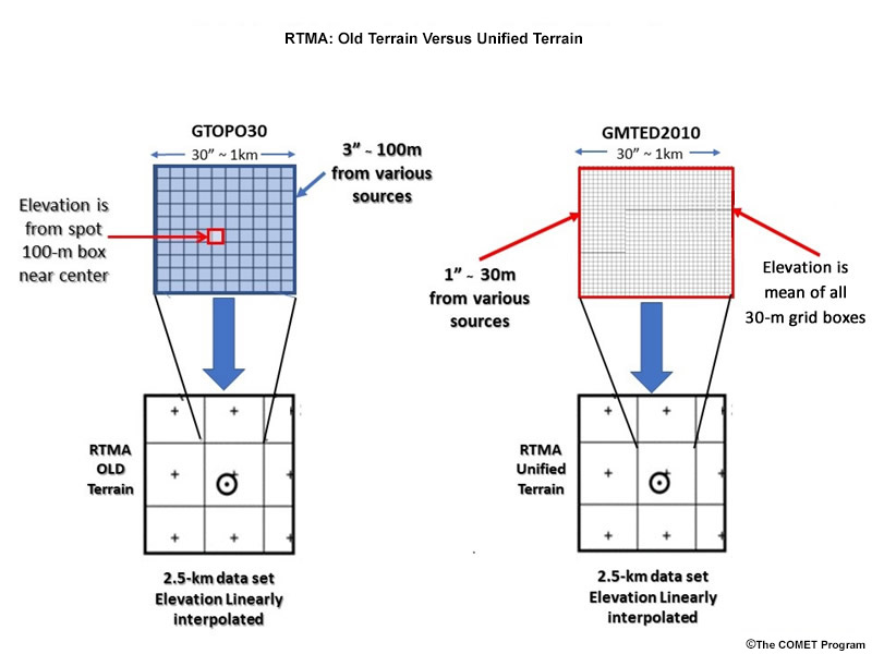
Description:
A schematic of two methods of interpolating high resolution terrain data sets to other coarser grids
File Name:
terrain2.jpg
Credits:
©The COMET Program
Copyright Terms:
COMET Standard Terms of Use
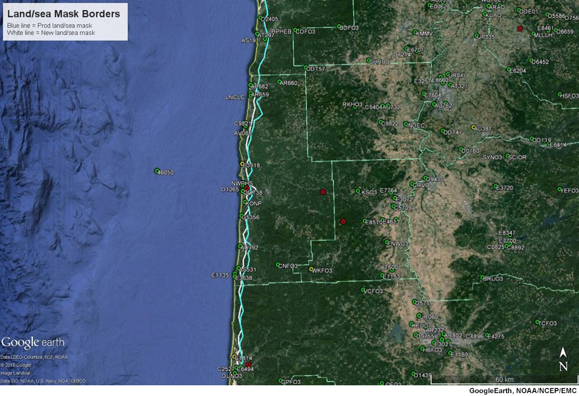
Description:
URMA old versus new land-sea mask or coastline, central Oregon coast.
File Name:
URMA_old_v_new_coastline.jpg
Credits:
GoogleEarth, NOAA/NCEP/EMC
Copyright Terms:
COMET Standard Terms of Use
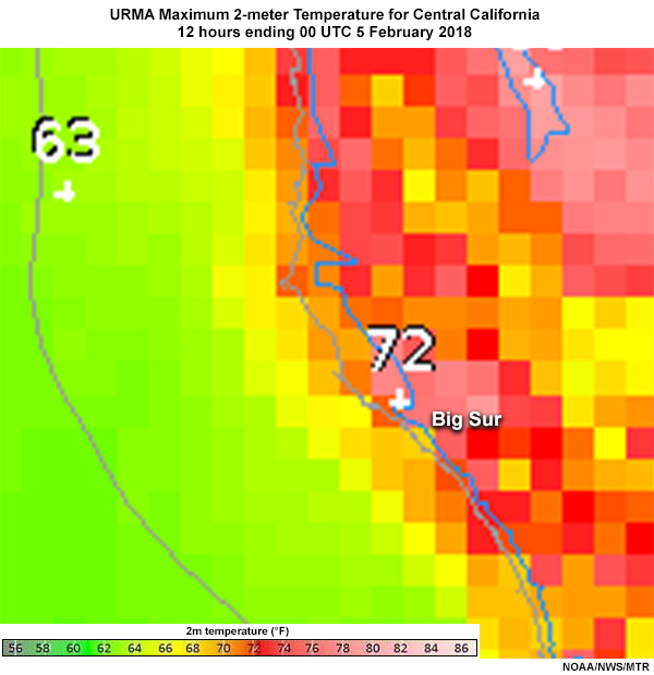
Description:
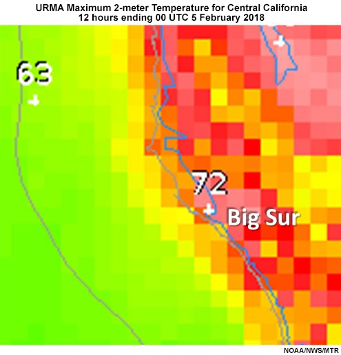
Unrestricted mesoscale analysis maximum 2-meter temperature for Big Sur CA area for 12 hours ending 00 UTC 5 February 2018
File Name:
URMA_Tmax4Feb2018_BigSur.jpg
Credits:
NOAA/NWS/MTR
Copyright Terms:
COMET Standard Terms of Use
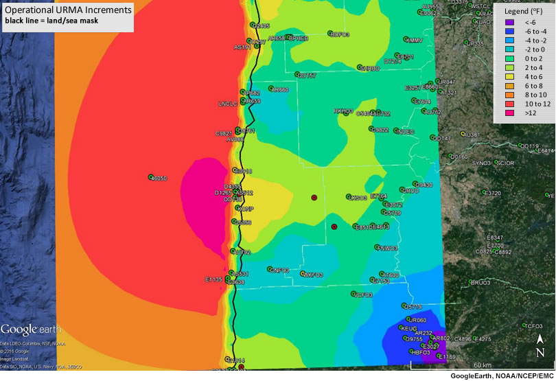
Description:
URMA analysis increment before shoreline correction, central Oregon coast.
File Name:
URMAOper_incr_ORcoast.jpg
Credits:
GoogleEarth, NOAA/NCEP/EMC
Copyright Terms:
COMET Standard Terms of Use
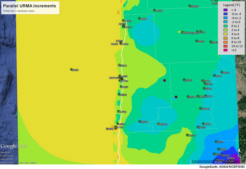
Description:
URMA analysis increment after shoreline correction, central Oregon coast.
File Name:
URMAPara_incr_ORcoast.jpg
Credits:
GoogleEarth, NOAA/NCEP/EMC
Copyright Terms:
COMET Standard Terms of Use
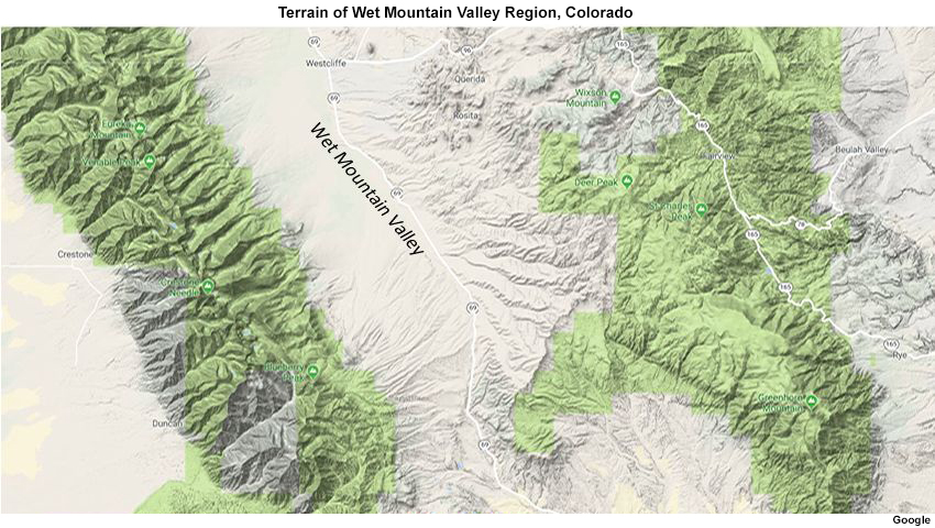
Description:
Terrain in and surrounding Wet Mountain Valley, Colorado, showing area is conducive to cold air pooling.
File Name:
wetmtnvalley_terrain.jpg
Credits:
Google
Copyright Terms:
COMET Standard Terms of Use