|
The new chart covers the “northern latitudes” of North
America, in other words, Alaska, Canada and the northern part of
the U.S. lower 48. The basic field on the chart, in a lavender colour,
is the area where EPV < 0 somewhere in the 700-500 mb layer,
based on the GEM regional forecast model. Progs are produced for
6-hour intervals from 00 hr to 48 hr. The 700-500 mb layer was chosen
since forecast experience, at least over western Canada, suggests
that the bulk of the CSI will occur at levels above the height of
the terrain where the geostrophic approximation applies. However,
a second set of charts, for the layer 850-700 mb, is also produced
to account for the possibility of CSI at lower levels, particularly
over areas where the terrain is lower than in the West.
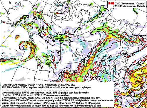 According
to Moore and Lambert (1993), “the release of CSI requires a
near-saturated environment with a lifting mechanism.” As a
result, the CMC EPV charts include, in pale blue, regions where
the model forecasts EPV < 0 and upward vertical motion. A third
colour, pale green, defines those regions where the first two criteria
are satisfied, and RH > 80% (the instability is conditional on
adequate humidity). These fields are presented in an attempt to
define where CSI has the possibility of being released. According
to Moore and Lambert (1993), “the release of CSI requires a
near-saturated environment with a lifting mechanism.” As a
result, the CMC EPV charts include, in pale blue, regions where
the model forecasts EPV < 0 and upward vertical motion. A third
colour, pale green, defines those regions where the first two criteria
are satisfied, and RH > 80% (the instability is conditional on
adequate humidity). These fields are presented in an attempt to
define where CSI has the possibility of being released.
As discussed in the background section of this document, regions
where EPV < 0 can contain areas of ordinary conditional instability
(possibly leading to vertical convection), as well as areas of CSI.
Where the two types of instability coexist, the ordinary conditional
instability and vertical convection will predominate. The CMC EPV
charts present, in yellow, areas where EPV < 0 and where the
GEM regional model has produced convective (as opposed to stratiform)
precipitation in the three hours leading up to the forecast time
(except for the 00 hr prog, in which the three hours following that
initial time are used). The yellow region is therefore a first attempt
to define areas of vertical conditional instability, where CSI will
not be the primary precipitation mechanism. The forecaster must,
of course, be aware of possible problems in the model’s forecast
of convection and compensate as necessary.
Western Canadian meteorologists who have some experience with CSI
suggested two further fields for the CMC chart: areas where the
EPV < 0 layer is thicker than 50 mb (outlined with a black contour)
and those where the EPV < 0 layer is thicker than 100 mb (outlined
with a red contour). These layers attempt to define where CSI may
exist in over sufficiently thick layers to produce precipitation.
All these fields are briefly described in the chart labels. The
charts are produced at the end of the GEM regional run, and should
be available at roughly 1530Z (day) and 0330Z (night). The charts
are considered experimental, and execute in a personal account at
CMC. They are not part of the GEM regional run, and are not supported
operationally, so they may be missing at times, though recent experience
suggests they will almost always be available.
< background
| top | go to charts > |