Media elements used in this module are protected by a variety of copyright licenses. Please use the "copyright terms" link associated with each item below for more information.
Description:
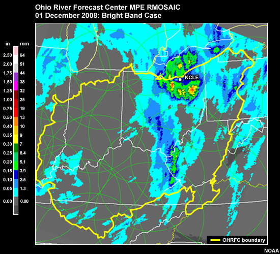
Radar precip mosaic with bright band at the OHRFC on 1 Dec 2008.
File Name:
01dec08_OHRFC-BB.jpg
Credits:
NOAA
Copyright Terms:
COMET Standard Terms of Use
Description:
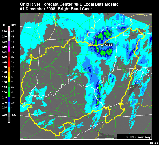
Radar precip mosaic with bright band at the OHRFC on 1 Dec 2008.
File Name:
01dec08_OHRFC-BB_LBmosaic.jpg
Credits:
NOAA
Copyright Terms:
COMET Standard Terms of Use
Description:
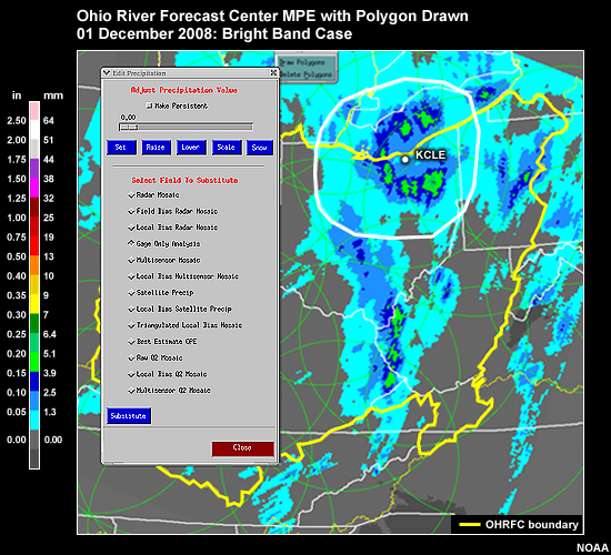
Radar precip mosaic with bright band. Polygon has been drawn to replace the bright band with gauge only field. OHRFC on 1 Dec 2008.
File Name:
01dec08_OHRFC-BB_Polygon.jpg
Credits:
NOAA
Copyright Terms:
COMET Standard Terms of Use
Description:
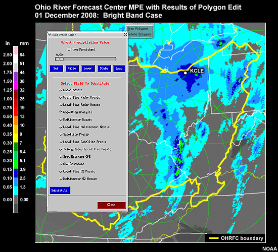
Radar precip mosaic with bright band. Polygon has been drawn and the area within the polygon that includes the bright band was replaced with gauge only field. OHRFC on 1 Dec 2008.
File Name:
01dec08_OHRFC-BB_Polygon-Gauge.jpg
Credits:
NOAA
Copyright Terms:
COMET Standard Terms of Use
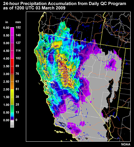
Description:
24-hour observed precipitation from the Daily QC program at the CNRFC: 1200 UTC 03 March 2009
File Name:
03Mar09_DailyQC-QPE_CNRFC.jpg
Credits:
NOAA
Copyright Terms:
COMET Standard Terms of Use
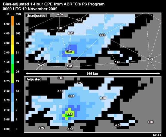
Description:
Bias-adjusted 1-Hour QPE from ABRFC?s P3 Program, 0000 UTC 10 November 2009
File Name:
10nov09_00_p3tin.jpg
Credits:
NOAA
Copyright Terms:
COMET Standard Terms of Use
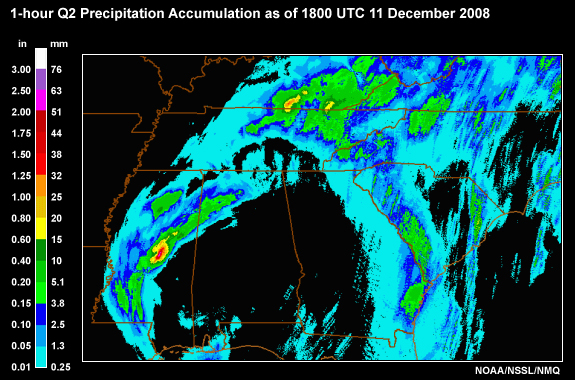
Description:
Radar-derived accumulation from NSSL's NMQ program for the 1-hour period ending at 1800 UTC 11 Dec 2008.
File Name:
11dec08_18z_1hQ2_modified.jpg
Credits:
NOAA/NSSL/NMQ
Copyright Terms:
COMET Standard Terms of Use
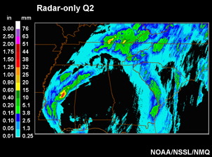
Description:
Radar-derived accumulation from NSSL's NMQ program for the 1-hour period ending at 1800 UTC 11 Dec 2008.
File Name:
11dec08_18z_1hQ2_small.jpg
Credits:
NOAA/NSSL/NMQ
Copyright Terms:
COMET Standard Terms of Use
Description:
National radar-derived accumulation from Q2 for the 24-hour period ending at 1200 UTC 12 Dec 2008.
File Name:
12dec08_12z_24hQ2_modified.jpg
Credits:
NOAA/NSSL/NMQ
Copyright Terms:
COMET Standard Terms of Use
Description:
National radar-derived accumulation from NSSL's NMQ program for the 24-hour period ending at 1200 UTC 12 Dec 2008.
File Name:
12dec08_12z_24hQ2_small.jpg
Credits:
NOAA/NSSL/NMQ
Copyright Terms:
COMET Standard Terms of Use
Description:
Radar-based 1-hour Accumulation with 1-hr Gauge Reports, Color Coded for QC
File Name:
13aug09_00z_lmosaic-gaugeQC.jpg
Credits:
NOAA
Copyright Terms:
COMET Standard Terms of Use
Description:
24-hour quantitative precipitation estimation from MPE at the OHRFC: 13 July 2008 1200 UTC
File Name:
13jul08_MPE_OHRFC.jpg
Credits:
NOAA
Copyright Terms:
COMET Standard Terms of Use
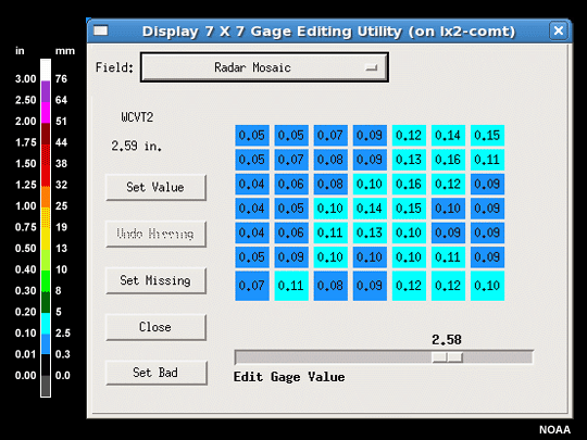
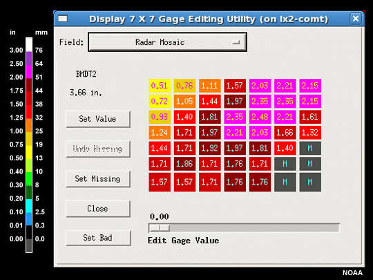
Description:
MPEs Display 7X7 for a Bad Gauge Report
File Name:
13mar09_18_7X7Rmos_badgage.gif
Credits:
NOAA
Copyright Terms:
COMET Standard Terms of Use
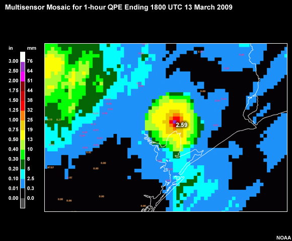
Description:
Multisensor Mosaic for 1-hour QPE Ending 1800 UTC 13 March 2009
File Name:
13mar09_18_MultiSens-Gage_Zoom.jpg
Credits:
NOAA
Copyright Terms:
COMET Standard Terms of Use
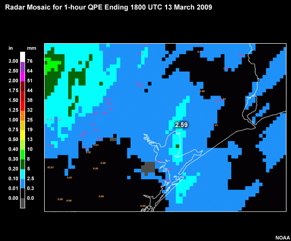
Description:
Radar Mosaic for 1-hour QPE Ending 1800 UTC 13 March 2009
File Name:
13mar09_18_RMos-Gage_Zoom.jpg
Credits:
NOAA
Copyright Terms:
COMET Standard Terms of Use
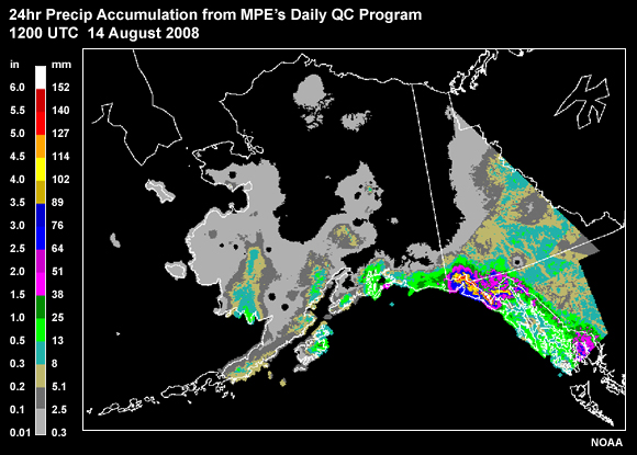
Description:
24hr Precip Accumulation from Daily QC Program 1200 UTC 14 August 2008
File Name:
14aug08_14z_dailyqcAPRFC.jpg
Credits:
NOAA
Copyright Terms:
COMET Standard Terms of Use
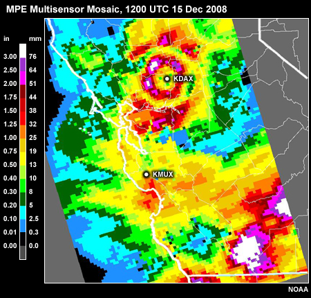
Description:
MPE Multisensor Mosaic, 1200 UTC 15 Dec 2008
File Name:
15dec08_12z_MTR_bestestimate.jpg
Credits:
NOAA
Copyright Terms:
COMET Standard Terms of Use
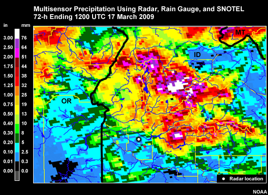
Description:
County map in the Boise, ID WFO area with 72-h radar-derived precip (KCBX) from MPE's Multisensor Precipitation Field using SNOTEL sites.
File Name:
15mar09_BOI_MPE.jpg
Credits:
NOAA
Copyright Terms:
COMET Standard Terms of Use
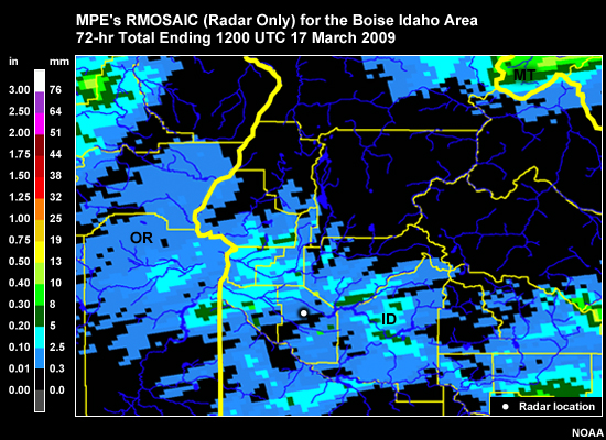
Description:
County map in the Boise, ID WFO area with 72-h radar-derived precip from the KCBX (Boise) radar.
File Name:
15mar09_BOI_radar.jpg
Credits:
NOAA
Copyright Terms:
COMET Standard Terms of Use
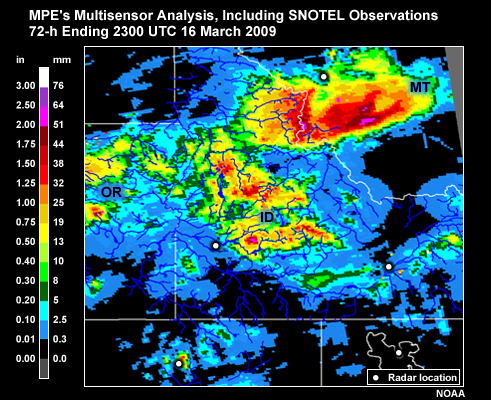
Description:
Idaho-region map with 72-h radar-derived precip ending 2300 UTC 16 March 2009 from MPE's multisensor analysis.
File Name:
16mar09_ID_multisensor.jpg
Credits:
NOAA
Copyright Terms:
COMET Standard Terms of Use
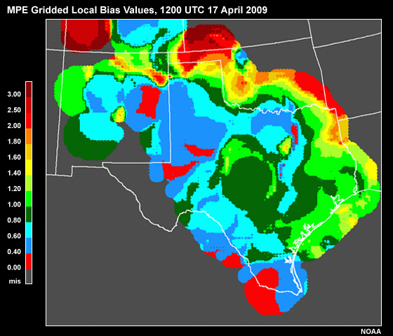
Description:
MPE Gridded Local Bias Values, 1200 UTC 17 April 2009
File Name:
17apr09_12z_localbias.jpg
Credits:
NOAA
Copyright Terms:
COMET Standard Terms of Use
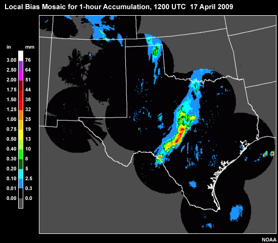
Description:
Local Bias Mosaic for 1-hour Accumulation
File Name:
17apr09_12z_localbiasradar.jpg
Credits:
NOAA
Copyright Terms:
COMET Standard Terms of Use
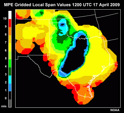
Description:
MPE Gridded Local Span Values, 1200 UTC 17 April 2009
File Name:
17apr09_12z_localspan.jpg
Credits:
NOAA
Copyright Terms:
COMET Standard Terms of Use
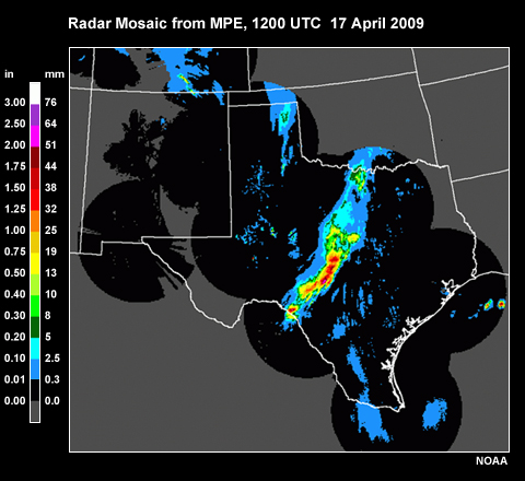
Description:
Radar Mosaic from MPE, 1200 UTC 17 April 2009
File Name:
17apr09_12z_rmosaic.jpg
Credits:
NOAA
Copyright Terms:
COMET Standard Terms of Use
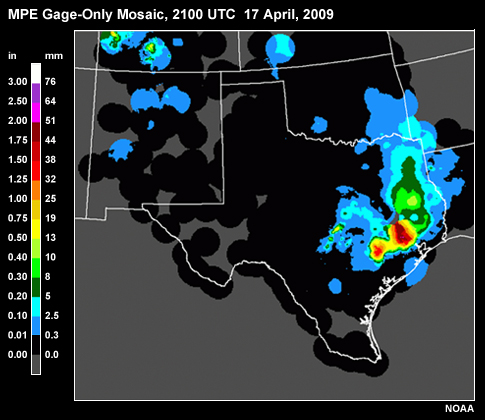
Description:
Gauge Only from MPE, 2100 UTC 17 April, 2009
File Name:
17apr09_21z_gaugeonly.jpg
Credits:
NOAA
Copyright Terms:
COMET Standard Terms of Use
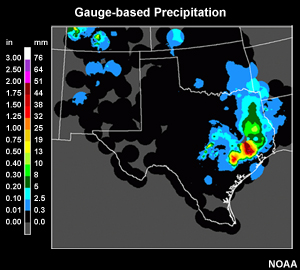
Description:
Gauge-only precip data sample 2100 UTC 17 April 2009 WGRFC
File Name:
17apr09_21z_gaugeonly_small.jpg
Credits:
NOAA
Copyright Terms:
COMET Standard Terms of Use
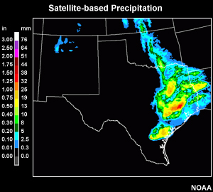
Description:
Satellite-only precip data sample 2100 UTC 17 April 2009 WGRFC
File Name:
17apr09_21z_satelliteonly_small.jpg
Credits:
NOAA
Copyright Terms:
COMET Standard Terms of Use
Description:
Display 7x7 Gauge Editing Utility Showing Radar Mosaic
File Name:
18apr09_20z_7X7RMosaic.gif
Credits:
NOAA
Copyright Terms:
COMET Standard Terms of Use
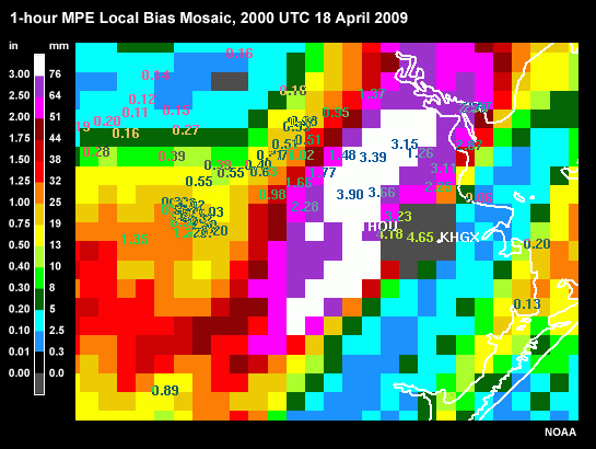
Description:
1-hour MPE Local Bias Mosaic, 2000 UTC 18 April 2009
File Name:
18apr09_20z_LBMosaic.jpg
Credits:
NOAA
Copyright Terms:
COMET Standard Terms of Use
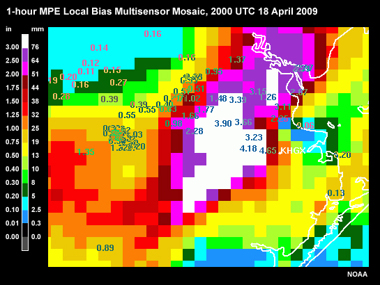
Description:
1-hour MPE Local Bias Multisensor Mosaic, 2000 UTC 18 April 2009
File Name:
18apr09_20z_LBMultiSensor.jpg
Credits:
NOAA
Copyright Terms:
COMET Standard Terms of Use
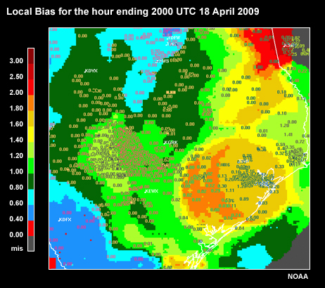
Description:
Local Bias for the hour ending 2000 UTC 18 April 2009
File Name:
18apr09_20z_localbias.jpg
Credits:
NOAA
Copyright Terms:
COMET Standard Terms of Use
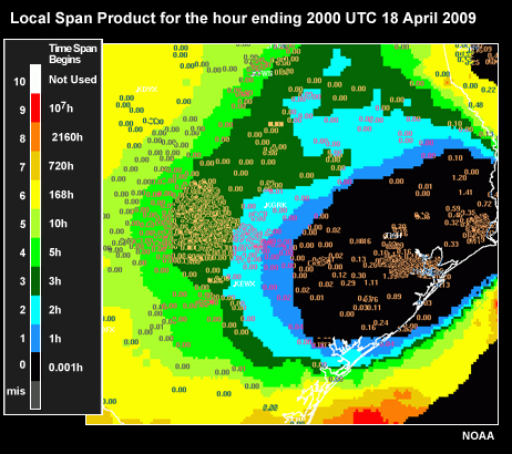
Description:
Local Span Product for the hour ending 2000 UTC 18 April 2009
File Name:
18apr09_20z_LocalSpan.jpg
Credits:
NOAA
Copyright Terms:
COMET Standard Terms of Use
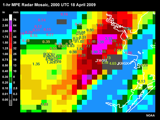
Description:
1-hour MPE Radar Mosaic, 2000 UTC 18 April 2009
File Name:
18apr09_20z_RMosaic.jpg
Credits:
NOAA
Copyright Terms:
COMET Standard Terms of Use
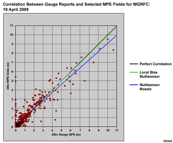
Description:
Correlation Between Gauge Reports and Selected MPE Fields for WGRFC: 19 April 2009
File Name:
19apr09_24h_scatterplot.gif
Credits:
NOAA
Copyright Terms:
COMET Standard Terms of Use
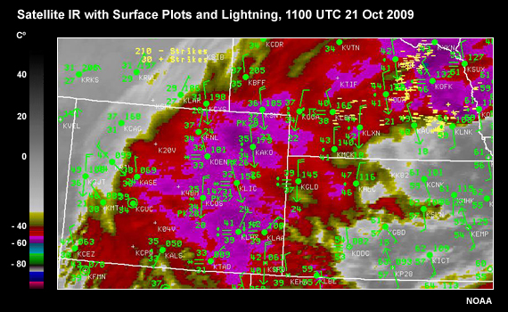
Description:
Surface IR from 21 Oct 2009 1100 UTC showing ares of snow, rain and lightning.
File Name:
21oct09_11z_sfc-ir.jpg
Credits:
NOAA
Copyright Terms:
COMET Standard Terms of Use
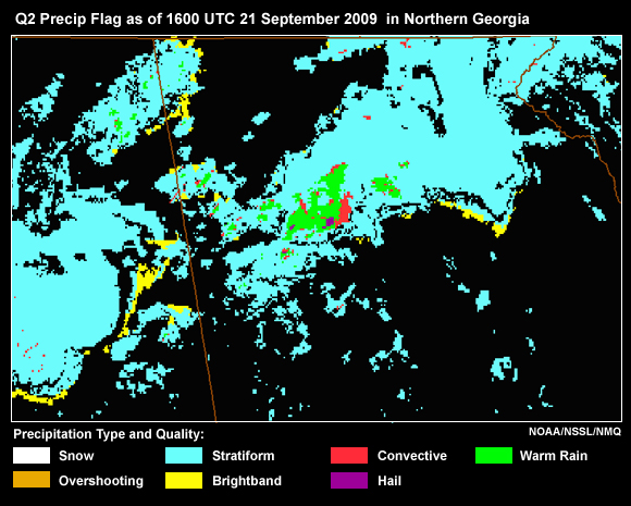
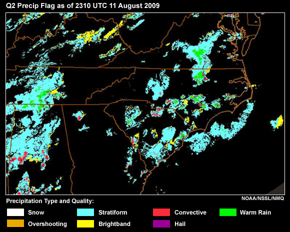
Description:
Q2 Precipitation Flag as of 1600 UTC 21 September 2009 in Northern Georgia
File Name:
21sep09_21z_precipflag.jpg
Credits:
NOAA/NSSL/NMQ
Copyright Terms:
COMET Standard Terms of Use
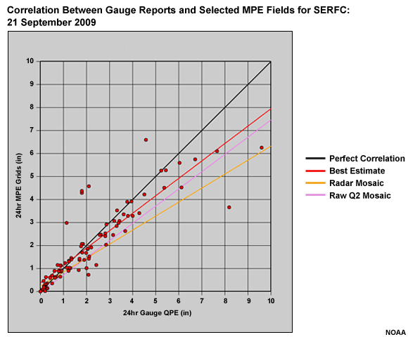
Description:
Correlation Between Gauge Reports and Selected MPE Fields for SERFC: 19-22 September 2009
File Name:
21sep09_24h_scatterplot.gif
Credits:
NOAA
Copyright Terms:
COMET Standard Terms of Use
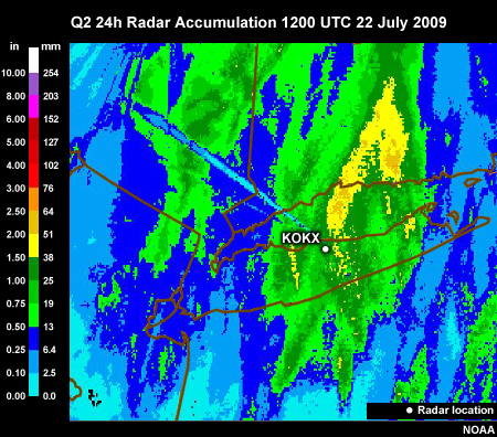
Description:
Q2 24-h Radar Precip from KOKX radar as of 1200 UTC 22 July 2009 showing beam blockage.
File Name:
22jul09_12z_Q2-24h.jpg
Credits:
NOAA
Copyright Terms:
COMET Standard Terms of Use
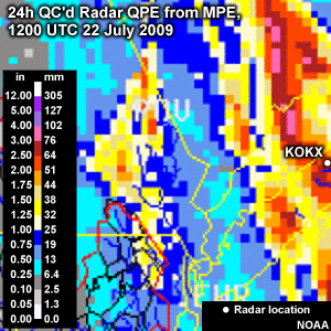
Description:
MPE QC'd 24-h Radar Precip zoomed to southeastern NY for the period ending 1200 UTC 22 July 2009. Beam blockage has been corrected.
File Name:
22jul09_12z_QCd24h_MPE-QPE_zoom.jpg
Credits:
NOAA
Copyright Terms:
COMET Standard Terms of Use
Description:
MPE 24-h Radar Precip from KOKX radar as of 1200 UTC 22 July 2009 showing corrected beam blockage.
File Name:
22jul09_12z_QCd24h_MPE-QPE_zoom.jpg
Credits:
NOAA
Copyright Terms:
COMET Standard Terms of Use
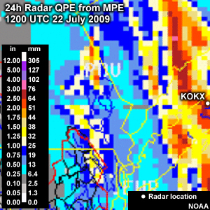
Description:
MPE 24-h Radar Precip zoomed to southeastern NY for the period ending 1200 UTC 22 July 2009. Beam blockage can be seen.
File Name:
22jul09_12z24h_MPE-QPE_zoom.jpg
Credits:
NOAA
Copyright Terms:
COMET Standard Terms of Use
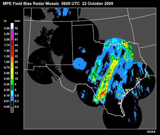
Description:
MPE Field Bias Radar Mosaic, 22 October 2009, 0600 UTC
File Name:
22oct09_06z_FBmosaic.jpg
Credits:
NOAA
Copyright Terms:
COMET Standard Terms of Use
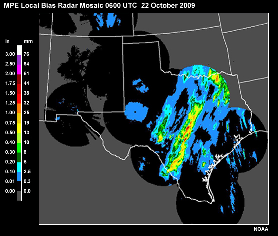
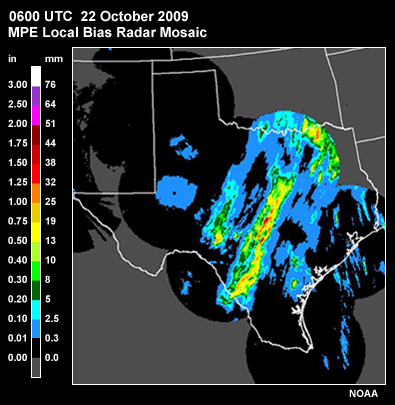
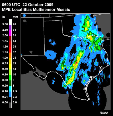
Description:
MPE Local Bias Radar Mosaic, 22 October 2009, 0600 UTC
File Name:
22oct09_06z_LBmosaic.jpg
Credits:
NOAA
Copyright Terms:
COMET Standard Terms of Use
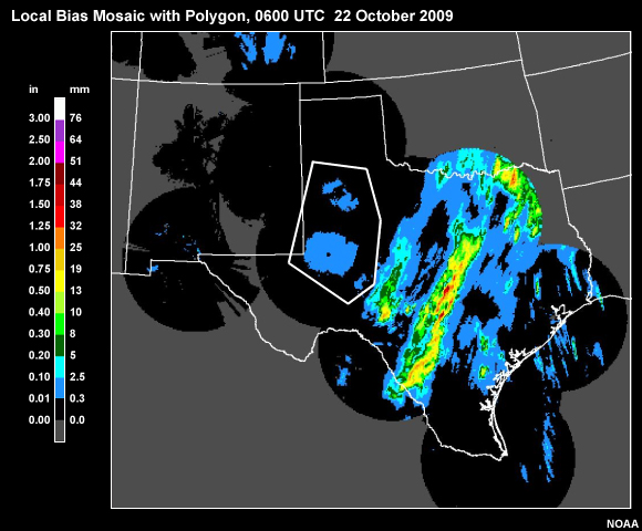
Description:
Local Bias Mosaic with Polygon
File Name:
22oct09_06z_LBmosaic-poly1.jpg
Credits:
NOAA
Copyright Terms:
COMET Standard Terms of Use
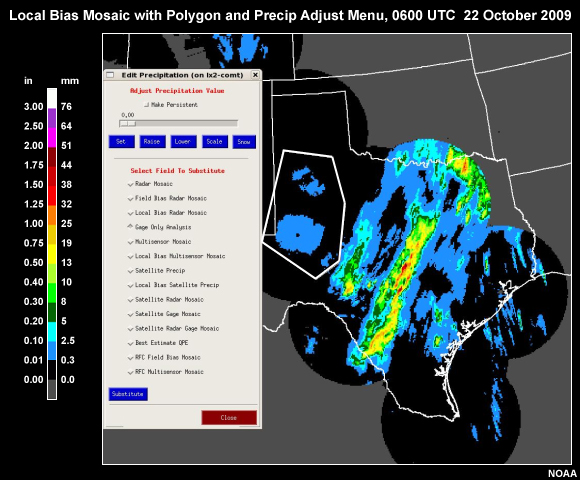
Description:
Local Bias Mosaic with Polygon with menu
File Name:
22oct09_06z_LBmosaic-poly2.jpg
Credits:
NOAA
Copyright Terms:
COMET Standard Terms of Use
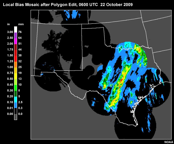
Description:
Local Bias Mosaic after Polygon Edit
File Name:
22oct09_06z_LBmosaic-poly3.jpg
Credits:
NOAA
Copyright Terms:
COMET Standard Terms of Use
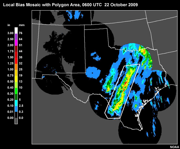
Description:
Local Bias Mosaic with Polygon Area
File Name:
22oct09_06z_LBmosaic-poly4.jpg
Credits:
NOAA
Copyright Terms:
COMET Standard Terms of Use
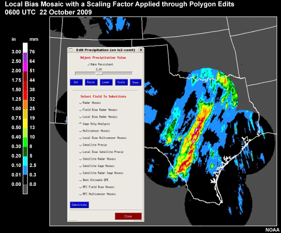
Description:
Local Bias Mosaic after Polygon Edit for Scaling
File Name:
22oct09_06z_LBmosaic-poly5.jpg
Credits:
NOAA
Copyright Terms:
COMET Standard Terms of Use
Description:
MPE Local Bias Radar Mosaic, 22 October 2009, 0600 UTC
File Name:
22oct09_06z_LBMosaicSmall.jpg
Credits:
NOAA
Copyright Terms:
COMET Standard Terms of Use
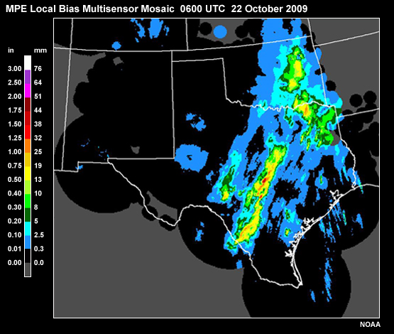
Description:
MPE Local Bias Multisensor Mosaic, 22 October 2009, 0600 UTC
File Name:
22oct09_06z_LBmultisensor.jpg
Credits:
NOAA
Copyright Terms:
COMET Standard Terms of Use
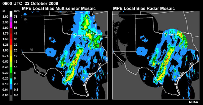
Description:
MPE Local Bias Radar Mosaic and MPE Local Bias Multisensor Mosaic , 22 October 2009, 0600 UTC
File Name:
22oct09_06z_LBmultisensor_LBmosaic.jpg
Credits:
NOAA
Copyright Terms:
COMET Standard Terms of Use
Description:
MPE Local Bias Multisensor Mosaic, 22 October 2009, 0600 UTC
File Name:
22oct09_06z_LBmultisensorSmall.jpg
Credits:
NOAA
Copyright Terms:
COMET Standard Terms of Use
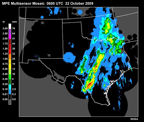
Description:
MPE Multisensor Mosaic, 22 October 2009, 0600 UTC
File Name:
22oct09_06z_multisensor.jpg
Credits:
NOAA
Copyright Terms:
COMET Standard Terms of Use
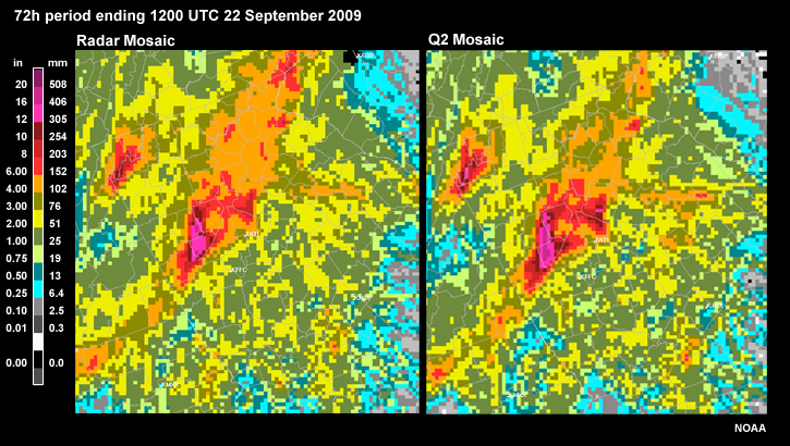
Description:
Radar Mosaic and Q2 Mosaic for the 72h period ending 1200 UTC 22 September 2009
File Name:
22sep09_12z_72h_RmosaicwithQ2raw.jpg
Credits:
NOAA
Copyright Terms:
COMET Standard Terms of Use
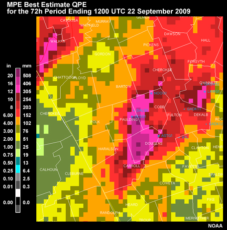
Description:
MPE Best Estimate QPE for the 72h period ending 1200 UTC 22 September 2009
File Name:
22sep09_12z_72h_XMRG-bestest.jpg
Credits:
NOAA
Copyright Terms:
COMET Standard Terms of Use
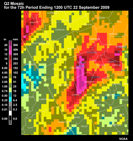
Description:
Q2 Mosaic for the 72h period ending 1200 UTC 22 September 2009
File Name:
22sep09_12z_72h_XMRG-Q2.jpg
Credits:
NOAA
Copyright Terms:
COMET Standard Terms of Use
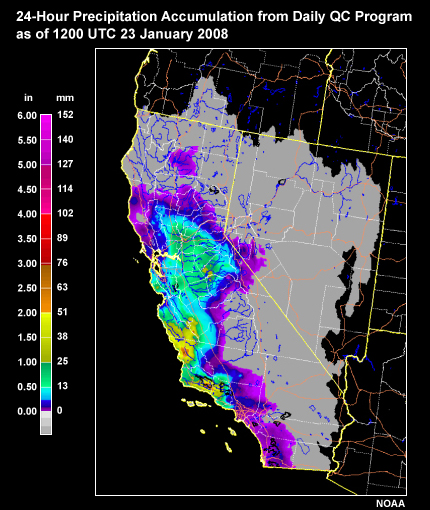
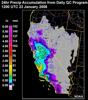
Description:
24-hour observed precipitation from the Daily QC program at the CNRFC: 23 January 1200 UTC
File Name:
23jan08_DailyQC-QPE_CNRFC.jpg
Credits:
NOAA
Copyright Terms:
COMET Standard Terms of Use
Description:
24-hour observed precipitation from the Daily QC program at the CNRFC: 23 January 1200 UTC
File Name:
23jan08_DailyQC-QPE_CNRFC_small.jpg
Credits:
NOAA
Copyright Terms:
COMET Standard Terms of Use
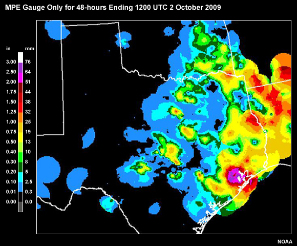
Description:
MPE Gauge Only for 48-hours Ending 1200 UTC 2 October 2009
File Name:
2oct09_12z-48h_gaugeonly.jpg
Credits:
NOAA
Copyright Terms:
COMET Standard Terms of Use
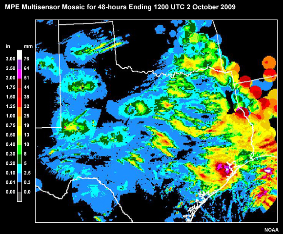
Description:
MPE Multisensor Mosaic for 48-hours Ending 1200 UTC 2 October 2009
File Name:
2oct09_12z-48h_multisensor.jpg
Credits:
NOAA
Copyright Terms:
COMET Standard Terms of Use
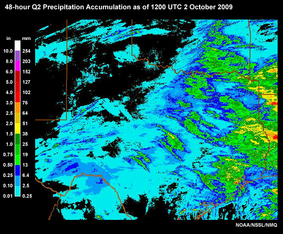
Description:
Q2 QPE Mosaic for 48-hours Ending 1200 UTC 2 October 2009
File Name:
2oct09_12z-48h_Q2.jpg
Credits:
NOAA/NSSL/NMQ
Copyright Terms:
COMET Standard Terms of Use
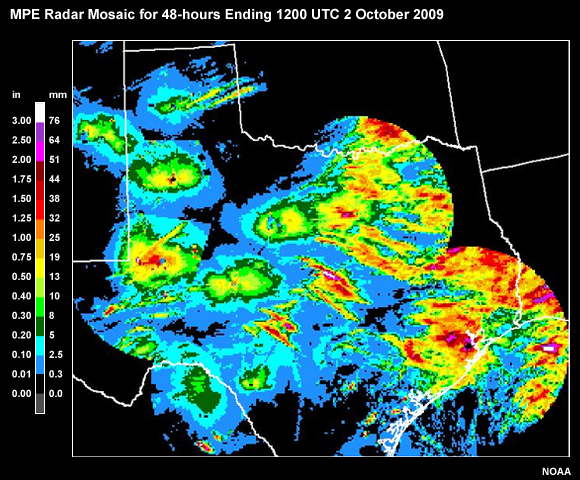
Description:
MPE Radar Mosaic for 48-hours Ending 1200 UTC 2 October 2009
File Name:
2oct09_12z-48h_rmosaic.jpg
Credits:
NOAA
Copyright Terms:
COMET Standard Terms of Use
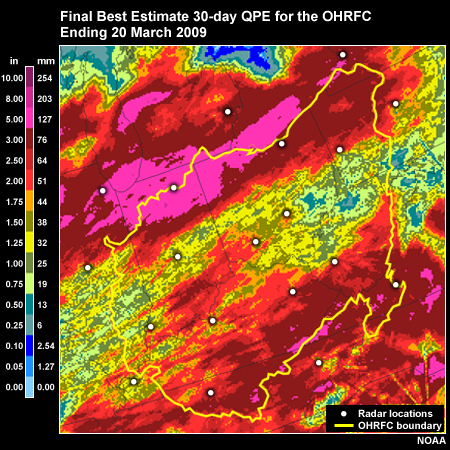
Description:
Final Best Estimate QPE for 30-day Period for the OHRFC Ending 20 March 2009
File Name:
30day_finalQPE.jpg
Credits:
NOAA
Copyright Terms:
COMET Standard Terms of Use
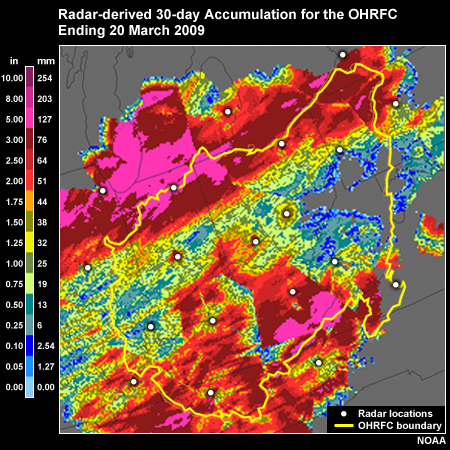
Description:
Unadjusted radar-derived QPE for the 30-day period ending 20 March 2009 for the OHRFC.
File Name:
30day_radarQPE.jpg
Credits:
NOAA
Copyright Terms:
COMET Standard Terms of Use
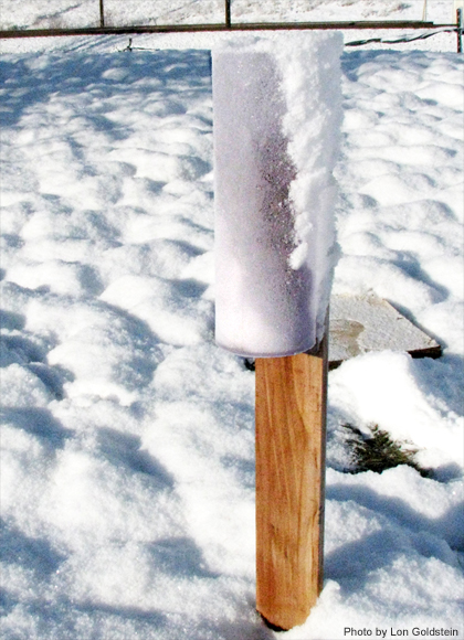
Description:
Blown snow in gauge.
File Name:
BlownSnowinGauge10-02-2009.jpg
Credits:
Photo by Lon Goldstein
Copyright Terms:
COMET Standard Terms of Use
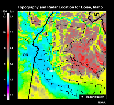
Description:
County map in the Boise, ID WFO area with radar (KCBX) location.
File Name:
BOI_topo.jpg
Credits:
NOAA
Copyright Terms:
COMET Standard Terms of Use
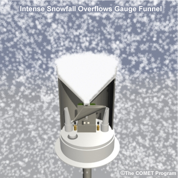
Description:
Intense Snowfall Overflows Gauge Funnel
File Name:
frozenprecip_gaugeoverflow.jpg
Credits:
The COMET Program
Copyright Terms:
COMET Standard Terms of Use
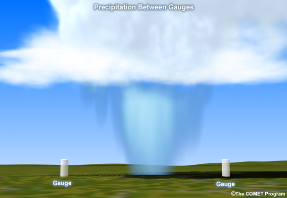
Description:
Illustration of precipitation missing gauges.
File Name:
gauge_estimates.jpg
Credits:
The COMET Program
Copyright Terms:
COMET Standard Terms of Use
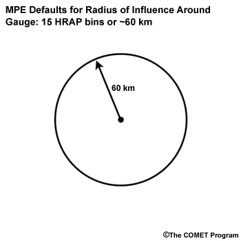
Description:
Circle showing radar location in center of circle with arrow along radius from center point to circle perimeter labeled 60 km
File Name:
gauge_radius.jpg
Credits:
The COMET Program
Copyright Terms:
COMET Standard Terms of Use
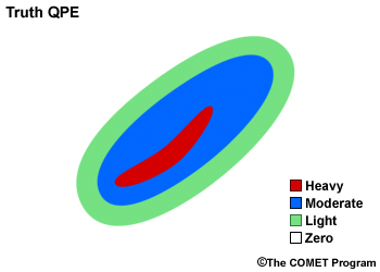
Description:
Illustration of effect of blocked sector on radar QPE.
File Name:
gauge-adj-radar_1.jpg
Credits:
The COMET Program
Copyright Terms:
COMET Standard Terms of Use
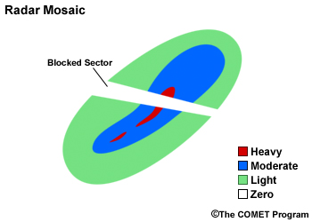
Description:
Illustration of effect of blocked sector on radar QPE: Radar QPE
File Name:
gauge-adj-radar_3.jpg
Credits:
The COMET Program
Copyright Terms:
COMET Standard Terms of Use
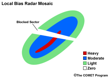
Description:
Illustration of effect of blocked sector on radar QPE.
File Name:
gauge-adj-radar_5.jpg
Credits:
The COMET Program
Copyright Terms:
COMET Standard Terms of Use
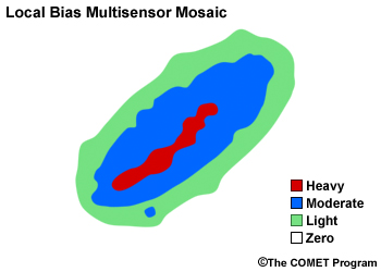
Description:
Illustration of effect of blocked sector on radar QPE: Multisensor QPE: Merged Radar and Gauge
File Name:
gauge-adj-radar_6.jpg
Credits:
The COMET Program
Copyright Terms:
COMET Standard Terms of Use
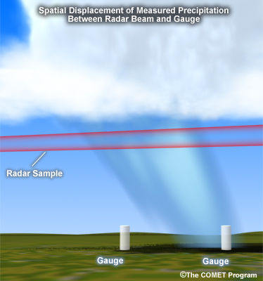
Description:
Illustration of spatial displacement of measured precipitation between radar and gauge.
File Name:
gauge-radar-spatial-displacement.jpg
Credits:
The COMET Program
Copyright Terms:
COMET Standard Terms of Use
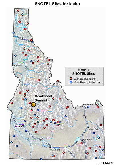
Description:
SNOTEL stations in Idaho with Deadwood Summit highlighted
File Name:
Idaho_SNOTEL_locs.jpg
Credits:
USDA NRCS
Copyright Terms:
COMET Standard Terms of Use
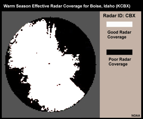
Description:
Warm season radar coverage for the Boise, ID (KCBX) radar.
File Name:
KCBX_RadCov_Summer.jpg
Credits:
NOAA
Copyright Terms:
COMET Standard Terms of Use
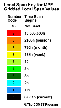
Description:
Local Span Key for MPE Gridded Local Span Values
File Name:
local_span_key.gif
Credits:
The COMET Program
Copyright Terms:
COMET Standard Terms of Use
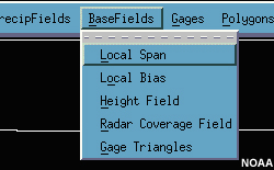
Description:
MPE BaseFields menu
File Name:
mpe_basefieldsmenu.jpg
Credits:
NOAA
Copyright Terms:
COMET Standard Terms of Use
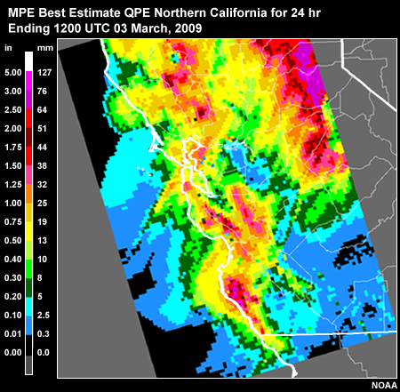
Description:
MPE Best Estimate QPE Northern California for 24 hr ending 1200 UTC 03 March, 2009
File Name:
MPE_best_estimate_12-12z02-03Mar09.jpg
Credits:
NOAA
Copyright Terms:
COMET Standard Terms of Use
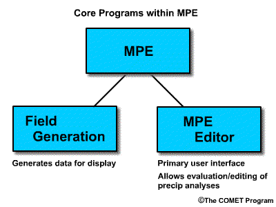
Description:
Diagram showing core programs of MPE
File Name:
mpe_coreprograms.gif
Credits:
The COMET Program
Copyright Terms:
COMET Standard Terms of Use
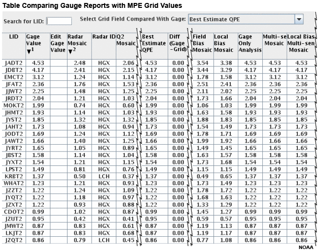
Description:
Gauge table allowing a forecaster to interrogate a specific gauge value and compare it with other precipitation estimates.
File Name:
MPE_GageTable22Z_18-April_2009.gif
Credits:
NOAA
Copyright Terms:
COMET Standard Terms of Use
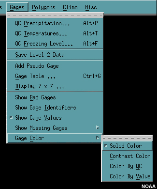
Description:
MPE Gages menu with colors sub menu
File Name:
mpe_gauges_color_menu.jpg
Credits:
NOAA
Copyright Terms:
COMET Standard Terms of Use
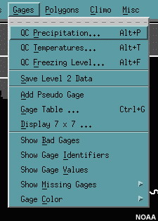
Description:
MPE Gages menu
File Name:
mpe_gaugesmenu.jpg
Credits:
NOAA
Copyright Terms:
COMET Standard Terms of Use
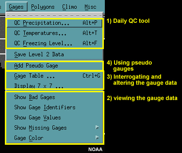
Description:
MPE Gages menu labelled.
File Name:
mpe_gaugesmenu_labelled.jpg
Credits:
NOAA
Copyright Terms:
COMET Standard Terms of Use
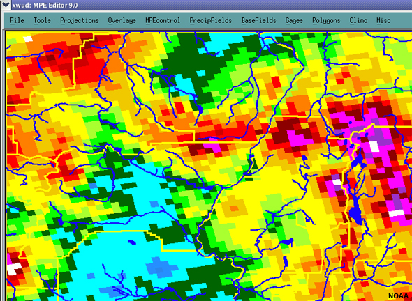
Description:
Main menus of MPE program
File Name:
MPE_MainGUI.jpg
Credits:
NOAA
Copyright Terms:
COMET Standard Terms of Use
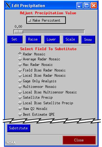
Description:
Menu to adjust precipitation values in MPE.
File Name:
mpe_polygons-editprecipmenu.jpg
Credits:
NOAA
Copyright Terms:
COMET Standard Terms of Use
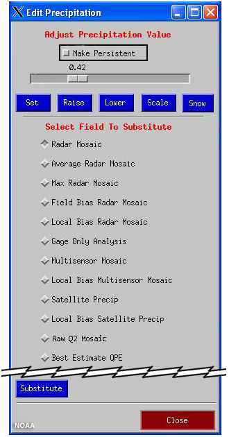
Description:
Menu to adjust precipitation values in MPE with
File Name:
mpe_polygons-editprecipmenu-set42.jpg
Credits:
NOAA
Copyright Terms:
COMET Standard Terms of Use
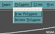
Description:
MPE Polygons menu
File Name:
mpe_polygonsmenu.jpg
Credits:
NOAA
Copyright Terms:
COMET Standard Terms of Use
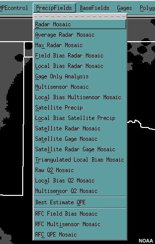
Description:
MPE PrecipFields menu
File Name:
mpe_precipfieldsmenu.jpg
Credits:
NOAA
Copyright Terms:
COMET Standard Terms of Use
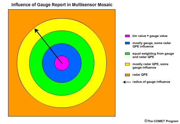
Description:
Influence of Gauge Report in Multisensor Mosaic
File Name:
multisensor_gaugeradius.jpg
Credits:
The COMET Program
Copyright Terms:
COMET Standard Terms of Use
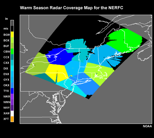
Description:
Warm Season Radar Coverage Map for the NERFC
File Name:
NERFC_radcov_map.jpg
Credits:
NOAA
Copyright Terms:
COMET Standard Terms of Use
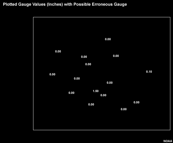
Description:
Gauge field with questionable non-zero gauge.
File Name:
non-zero_gauge_radar1.jpg
Credits:
NOAA
Copyright Terms:
COMET Standard Terms of Use
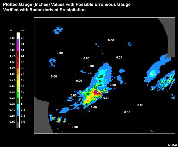
Description:
Gauge field with questionable non-zero gauge verified with radar-derived precipitation.
File Name:
non-zero_gauge_radar2.jpg
Credits:
NOAA
Copyright Terms:
COMET Standard Terms of Use
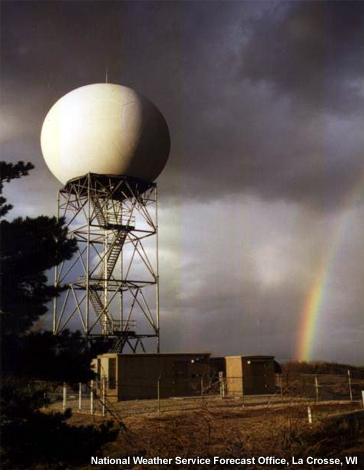
Description:
Radar dome at the National Weather Service Forecast Office in La Crosse, WI.
File Name:
norman_radar_dome.jpg
Credits:
National Weather Service Forecast Office, La Crosse, WI
Copyright Terms:
COMET Standard Terms of Use
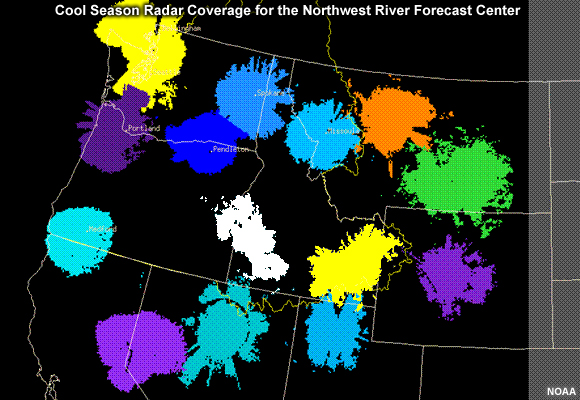
Description:
Cool season effective radar coverage based on radar climatology for the Northwest River Forecast Center area.
File Name:
NWRFC_CoolSeason_RadCov.jpg
Credits:
NOAA
Copyright Terms:
COMET Standard Terms of Use
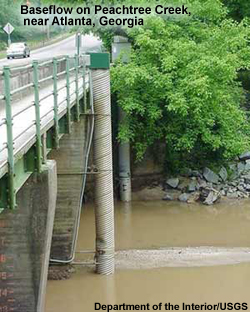
Description:
Baseflow on Peachtree Creek, near Atlanta, Georgia
File Name:
peachtree_creek_baseflow.jpg
Credits:
Department of the Interior/USGS
Copyright Terms:
COMET Standard Terms of Use
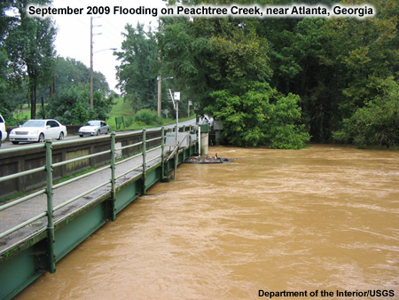
Description:
September 2009 Flooding on Peachtree Creek, near Atlanta, Georgia
File Name:
peachtree_creek_sept09_bridge.jpg
Credits:
Department of the Interior/USGS
Copyright Terms:
COMET Standard Terms of Use
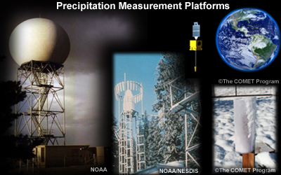
Description:
Collage of precipitation measurement platforms: radar, gauge, and satellite.
File Name:
precip_msrmnt_collage-small.jpg
Credits:
NOAA/NESDIS/The COMET Program
Copyright Terms:
COMET Standard Terms of Use
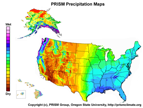
Description:
PRISM precipitation maps for CONUS, Alaska, and Hawaii
File Name:
PRISM_UScollage_addbar.jpg
Credits:
Copyright (c), PRISM Group, Oregon State University, http://prismclimate.org
Copyright Terms:
COMET Standard Terms of Use
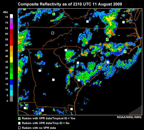
Description:
Composite Reflectivity as of 2310 UTC 11 August 2009
File Name:
Q2_CREF-radar_11aug09_2310z.jpg
Credits:
NOAA/NSSL/NMQ
Copyright Terms:
COMET Standard Terms of Use
Description:
Q2 Precipitation Flag as of 2310 UTC 11 August 2009
File Name:
Q2_PrecipFlag_11aug09_2310z.jpg
Credits:
NOAA/NSSL/NMQ
Copyright Terms:
COMET Standard Terms of Use
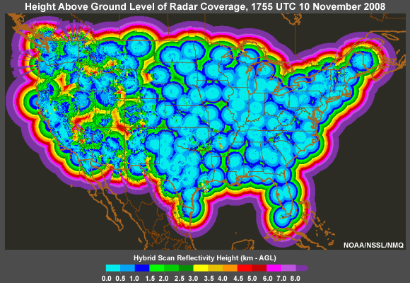
Description:
Height above ground level (AGL) of radar coverage within the CONUS as shown by the NOAA/NSSL/NMQ website.
File Name:
Rad-height_coverage_Q2.jpg
Credits:
NOAA/NSSL/NMQ
Copyright Terms:
COMET Standard Terms of Use
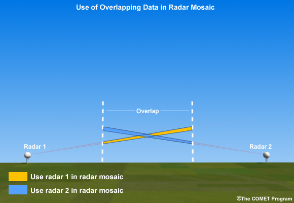
Description:
Use of Overlapping Data in Radar Mosiac
File Name:
radarmosaic_overlap.jpg
Credits:
The COMET Program
Copyright Terms:
COMET Standard Terms of Use
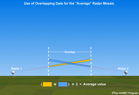
Description:
Use of Overlapping Data for the "Average" Radar Mosiac
File Name:
radarmosaic_overlap_avg.jpg
Credits:
The COMET Program
Copyright Terms:
COMET Standard Terms of Use
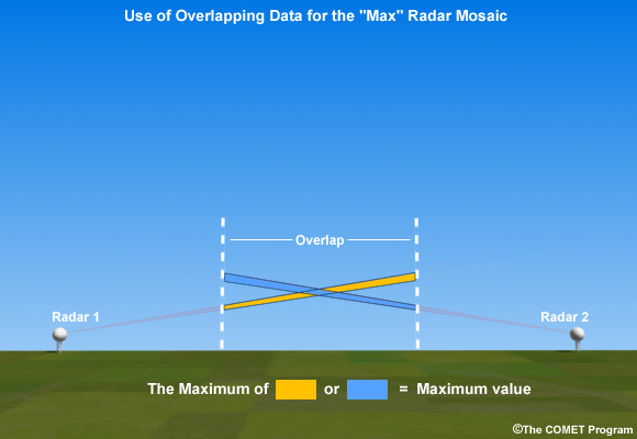
Description:
Use of Overlapping Data for the "Max" Radar Mosiac
File Name:
radarmosaic_overlap_max.jpg
Credits:
The COMET Program
Copyright Terms:
COMET Standard Terms of Use
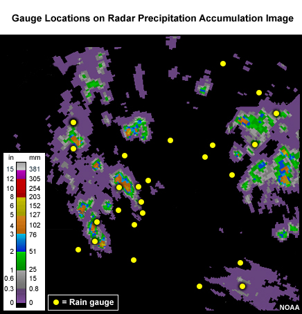
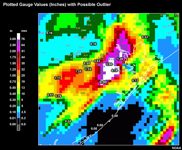
Description:
Gauge locations on a radar precip image
File Name:
radarrain_withgauge.jpg
Credits:
NOAA
Copyright Terms:
COMET Standard Terms of Use
Description:
SNOTEL Station at Oxford Spring, Idaho
File Name:
SNOTEL_OXFORD-SPRING.jpg
Credits:
USDA NRCS
Copyright Terms:
COMET Standard Terms of Use
Description:
SNOTEL Station at Oxford Spring, Idaho
File Name:
SNOTEL_OXFORD-SPRING_small.jpg
Credits:
USDA NRCS
Copyright Terms:
COMET Standard Terms of Use
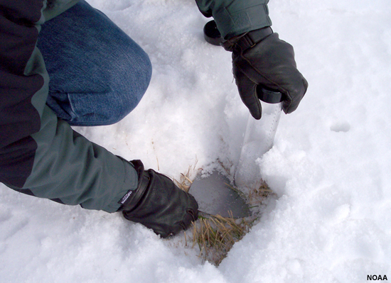
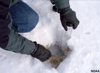
Description:
Taking a snow core sample.
File Name:
snow_core_sampling.jpg
Credits:
NOAA
Copyright Terms:
COMET Standard Terms of Use
Description:
Taking a snow core sample.
File Name:
snow_core_sampling_small.jpg
Credits:
NOAA
Copyright Terms:
COMET Standard Terms of Use
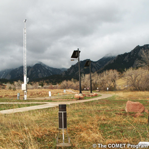
Description:
Rain gauge and location in Boulder, CO with foothills in background.
File Name:
Stratus1_12apr09_sm.jpg
Credits:
The COMET Program
Copyright Terms:
COMET Standard Terms of Use
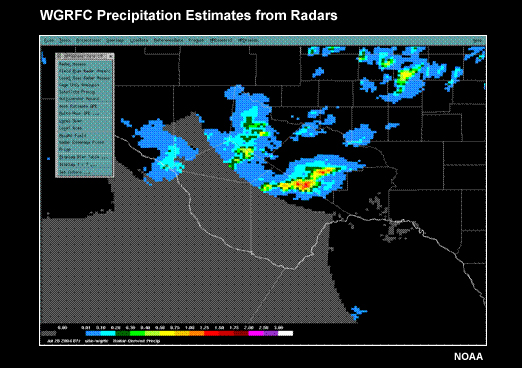
Description:
Precipitation Estimates in the West Gulf RFCAarea from Radar.
File Name:
WGRFC_MPE_example_1.jpg
Credits:
NOAA
Copyright Terms:
COMET Standard Terms of Use

Description:
Precipitation Estimates in the West Gulf RFC Area From Radar, Satellite, Gauges and Multisensor.
File Name:
WGRFC_MPE_example_1-4all.jpg
Credits:
NOAA
Copyright Terms:
COMET Standard Terms of Use
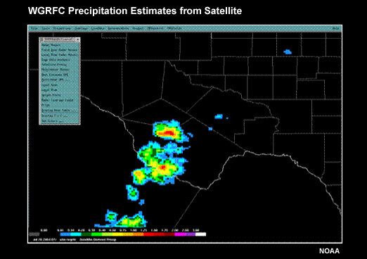
Description:
Precipitation Estimates in the West Gulf RFC Area from Satellite
File Name:
WGRFC_MPE_example_2.jpg
Credits:
NOAA
Copyright Terms:
COMET Standard Terms of Use
Description:
Precipitation Estimates in the West Gulf RFC Area From Gauges
File Name:
WGRFC_MPE_example_3.jpg
Credits:
NOAA
Copyright Terms:
COMET Standard Terms of Use
Description:
Precipitation Estimates in the West Gulf RFC Area From Gauges
File Name:
WGRFC_MPE_example_3-2.jpg
Credits:
NOAA
Copyright Terms:
COMET Standard Terms of Use
Description:
Precipitation Estimates in the West Gulf RFC Area for Radar, Satellite, and Gauges Combined.
File Name:
WGRFC_MPE_example_4.jpg
Credits:
NOAA
Copyright Terms:
COMET Standard Terms of Use
Description:
Gauge field with questionable zero gauge.
File Name:
zero_gauge_radar1.jpg
Credits:
NOAA
Copyright Terms:
COMET Standard Terms of Use
Description:
Gauge field with questionable zero gauge, now showing radar field overlay.
File Name:
zero_gauge_radar2.jpg
Credits:
NOAA
Copyright Terms:
COMET Standard Terms of Use