Table of Contents
- Introduction
- Interview the Experts
- Talk to a Meteorologist
- Why are AMDAR data needed?
- What is the quality of AMDAR data?
- What are the benefits of AMDAR data to Numerical Weather Prediction?
- How can AMDAR data be used in forecasting?
- How can the data be used for climate applications?
- Can AMDAR data help verify forecast products?
- What benefits do AMDAR water vapour data offer?
- Test your knowledge
- Talk to an Airline Representative
- Talk to an AMDAR Systems Manager
- Next Steps
- Survey
Introduction
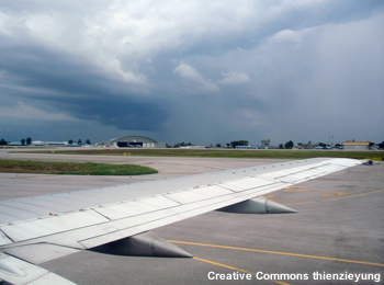
You are a director of a meteorological service on a site visit to a regional office. You are conversing with Akriti Venk, the regional manager, when you hear an urgent knock on the door. Sonia, one of the local forecasters, walks in quickly and says, Sorry to interrupt, but we have a problem. An air traffic manager called and told me that a transcontinental passenger jet has encountered stronger headwinds than anticipated at 32,000 feet. He is concerned that they will run out of fuel over the ocean and not reach their airport. He needs help now but none of our tools allows me to see the wind speeds at flight altitudes to find more favourable conditions. Can we do anything to help?
A colleague in another weather service told me that they have just obtained access to aircraft weather data through a program called AMDAR. The aircraft data provide information about wind speed and other conditions at flight altitudes. Ill call him right away and see if he can help. May I use your phone, Akriti?
Go right ahead.
You dial your colleagues number. Hi, Francisco. We have an urgent problem with an aircraft running low on fuel because of headwinds. Could you take a look at your current AMDAR data and tell us which altitudes or areas might have more favourable winds?
Right away," says Francisco. "Where is the plane currently?
They are over the Atlantic Ocean about 240 km northeast of Nassau in The Bahamas. Their altitude is 32,000 feet, heading due west en route to Miami, you reply.
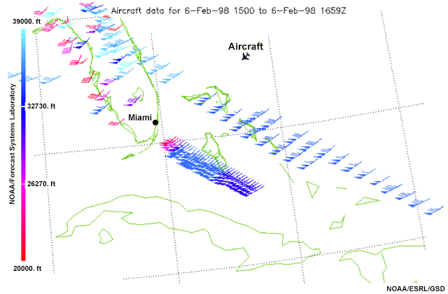
All right. Let me pull it up. Hmm... OK, here are some flight paths with data indicating that between 18,000 and 20,000 feet the winds are much weaker. I suggest that if they can, the traffic managers should get the plane to a lower altitude. There is also an area of lower wind speeds about 100 km to the south of their current position. says Francisco.
Thanks, Francisco! Turning to Sonia you say: "Sonia, tell the manager that winds are favourable between 18,000 and 20,000 feet and about 100 km south of their current location."
Ill contact them right away, says Sonia, who disappears quickly.
Thirty minutes later Sonia returns. She looks relieved. I just heard from the traffic manager that the plane is on track for final approach. The new altitude had lower headwind speeds and the aircraft is making better time. She pauses and then says, These data could be really useful for us, too. What would it take for our weather service to be able to get access to AMDAR?
I dont know, Sonia, but the information available through AMDAR might have just prevented a serious incident...who really knows what would have happened? Even in the best situation, the flight may have had to detour to a different airport, and not all island airports are equipped for very large planes. And that wouldn't even take into account the cost of getting several hundred passengers from an alternate airport to Miami.
As Sonia leaves the room, Akriti reflects on the situation. We were fortunate that you were here today. The data were really useful," she says. "I know that AMDAR stands for Aircraft Meteorological Data Relay and it is a World Meteorological Organization, or WMO, program. Various aircraft collect and record observations including air temperature, wind speed and direction, and vertical profiles of the atmosphere with precise location and timing information and the airlines share these data with meteorological services. But I am not sure how it is set up. How much would the program cost to implement? I am not really sure that our airlines would share the costs of such a program; they would need to know more about what's involved and the benefits. Also, what are the communication requirements for transmitting and receiving the data from the instruments?
You are right. We have a lot to learn. The program is a collaboration between meteorological services and commercial airlines. I have heard that participating aircraft currently report over 600,000 daily observations, though there are many areas around the world where AMDAR coverage remains sparse. But given that AMDAR is capable of producing so many observations per day, I suspect the data must have quite a significant impact on the global and national computer models that we use for aviation forecasting—that would be reason enough for airlines to provide their data. I need to look into the benefits and requirements more closely.
Now that youve decided to learn more about AMDAR and how to implement it, you prepare specific questions to ask a meteorologist, an aviation representative, and an AMDAR systems manager. As you start your research, you might also look at this document on Aircraft-based Observations Statistics to learn more about how AMDAR is being used globally: WMO Aircraft-based Observations Data Statistics
Interview the Experts
You are ready to begin your inquiries about AMDAR. From this page you can choose to hear from a meteorologist, an airline representative, and an AMDAR systems manager. These experts will provide information about the benefits of AMDAR for weather forecasting, as well as for aircraft safety, flight operations and planning, and airport operations.
When you have finished learning about AMDAR from one of the experts, youll complete a set of review questions and then choose who would you like to visit next.
Who would you like to interview first?
Talk to a Meteorologist

Francisco Ferreira
You talk with Francisco Ferreira, who provided the data to help your forecaster with the potential crisis in the earlier scenario. The meteorological service who employs him has been using AMDAR data since 1999. Mr. Ferreira is also familiar with how meteorologists in other regions are using the data and has invited some of his forecast colleagues to provide information about the advantages of AMDAR.
Please select a question you would like to ask.
- Why are AMDAR data needed?
- What is the quality of AMDAR data? How does it compare to radiosondes?
- What are the benefits of AMDAR data to Numerical Weather Prediction?
- How can AMDAR data be used in forecasting?
- How can the data be used for climate applications?
- Can AMDAR data help verify forecast products?
- What benefits do AMDAR water vapour data offer?
Talk to a Meteorologist » Why are AMDAR data needed?
Many meteorological services have very limited radiosonde programs. Even in the U.S. and Europe, there are several major airports with no radiosondes within 200 km. Aircraft-based observations provide important upper air data that would not otherwise be available.
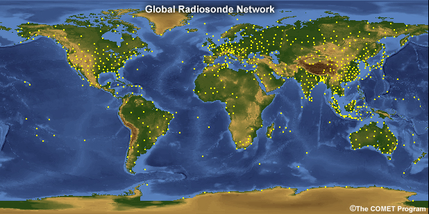
Global radiosonde locations.
In areas where AMDAR data are available, meteorologists and airlines can access vertical profiles of temperature and winds with 100-meter vertical resolution in the lower troposphere up to 700 hPa. Depending on the AMDAR participating airlines schedules, some airports have the capability of providing multiple profiles per hour.
AMDAR can measure or derive the following meteorological parameters with very accurate time, pressure altitude, and latitude and longitude coordinates:
- Air temperature (static air temperature)
- Wind speed and direction
- Pressure altitude (barometric pressure)
- Turbulence (Eddy Dissipation Rate or Derived Equivalent Vertical Gust, if the algorithm is installed)
- Water vapour (if sensor is installed)
Additional non-meteorological parameters that can be reported, measured or derived include:
- Icing indication including accreting or not accreting (pending)
- Departure and destination airport
- Aircraft roll angle
- Flight identifier
While in flight, an AMDAR-equipped aircraft reports the real-time meteorological variables above every 3-10 minutes. This animation illustrates how frequently AMDAR instruments transmit data during the various stages of flight.
AMDAR is a WMO program that facilitates the fully automated collection and transmission of weather observations from commercial aircraft. (WMO Integrated Global Observing System, WIGOS, Tech Report No. 2014-02, p.4) The program is a collaboration between National and Regional AMDAR programs and commercial airlines and is a critical part of WMO Global Observing System (GOS). GOS supports numerical weather prediction, public weather services, disaster warning and recovery, climate and meteorological research, and aeronautical meteorology.
AMDAR provides over 600,000 observations daily, from over 3,000 aircraft. The following graphic shows a small percentage of the available observations for a single day:
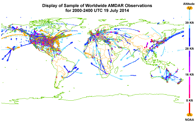
Still, many areas of the world have little or no AMDAR coverage. The more countries and airlines adopt AMDAR, the more beneficial the WMO Global Observation network will become.
An airline meteorologist provides his perspective about the importance of AMDAR data:

Rick Curtis, Southwest Airlines
Show/Hide Transcript
Why is this important? Ive got to go back to the analogy that it's the difference between a snapshot and a movie. A snapshot will give you what the state is at that second. A movie allows you to watch the changes over time and AMDAR provides us that ability--to be able to watch how the atmosphere changes over time. Until that was available you know we could do that from a radar, we could do it from a satellite, we can do it from ground observations but we certainly couldn't do it as far as profiles of the atmosphere.
Here are some thoughts about AMDARs role in traditionally data-sparse regions:

Dr. Olli Marius Turpeinen, Aviation Consultant
Show/Hide Transcript
The AMDAR data is needed and useful because there are so many areas over the world where it is impossible actually to have the traditional upper-air observations. We think simply about the fact that the vast majority of the Earth's surface is covered by oceans and we do not have that many island states. One of the few ways of getting observations over that area are aircraft observations. Therefore in my view, AMDAR's most important role is over the data sparse areas and in particular over oceans.
Show/Hide Transcript
The second thing I would like to comment on is the role of AMDAR data as far as the international civil aviation is concerned; and, in particular what the international convention says. If you go to the convention, there are only references made to so called operational meteorological data, which is a type of information required for flight planning and for undertaking the flight. ADMAR data is not part of that data type. AMDAR data is considered basic meteorological data, similar to synoptic observations or upper-air observations.
A forecaster from a national meteorological service offers this perspective about AMDAR:

Nicolas Major, Meteorological Service of Canada
Show/Hide Transcript
AMDAR data really helps us with the vertical profile of temperature and wind at various locations where we do not have data. There's so many places with sounding data and but they are only at fixed times. So, the advantage of AMDAR data is you can get this type of data on a much more frequent basis and at places where you normally don't get sounding data.
Talk to a Meteorologist » What is the quality of AMDAR data?
Specifically, how do AMDAR data compare to radiosondes? How does the cost compare to the cost of radiosondes?
AMDAR data costs analyzed over a four- to five-year period averages just ~US$15/profile (WMO, 2014). The radiosonde cost is ~US$300/profile. Ideally, the two systems should be regarded as complementary in the context of establishing, maintaining, and optimising a national observing system. In the case of National Meteorological and Hydrologic Services (NMHSs) struggling to find the capital to develop or maintain a sufficient radiosonde program, it can be seen that the AMDAR program does offer an extremely cost-effective means of maintaining or improving upper air coverage.
In some situations, the AMDAR data collected can be of higher quality than observations from radiosondes. Here is an example comparing AMDAR profiles (in magenta and orange) with a radiosonde profile (in black) for a similar time. Notice that the radiosonde sounding puts the height of the boundary layer at 2 km, while both AMDAR soundings report a 1.5-km boundary layer height.
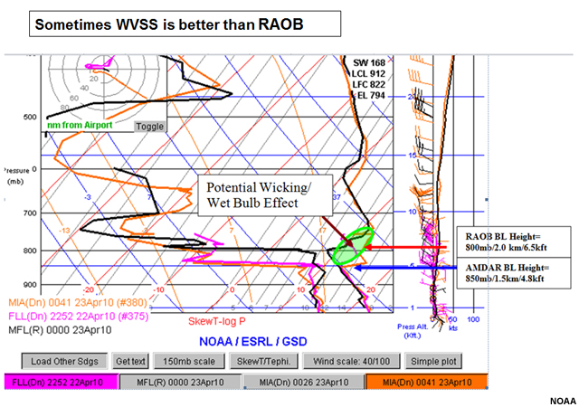
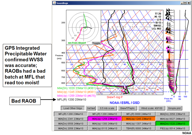
In the case for 23 March 2010 shown below, the radiosonde observation (in black) is too moist. The AMDAR sounding values (shown by the magenta, orange, and green profiles) were confirmed by GPS Integrated Precipitable Water estimates.
AMDAR data meets WMO measurement quality requirements for temperature reporting within +/- 1.0 °C; wind vectors within +/- 2-3 m/s; and pressure altitude within +/- 4 hPa.
Here are some comments on AMDAR data quality from a national meteorological service forecaster:

Rich Mamrosh, U.S. National Weather Service
Show/Hide Transcript
The quality of AMDAR is quite good. There has been extensive testing of AMDAR data, and the different elements of AMDAR such as TAMDAR and WVSS2. The first comparisons were done maybe 15 or 20 years ago and they were comparisons of temperature and wind data to nearby radiosondes. At the time, it was deduced that the temperature and wind data were equivalent to radiosondes, if not better. Recent comparisons have been done at Louisville at the United Parcel Service headquarters. There we've actually had mobile radiosonde units launching radiosondes every 30 minutes and comparing them to data from departing planes. This more recent data shows that the temperature and the wind data are superior to radiosondes. And the WVSS2 data - the water vapour data - is probably even better than radiosondes but we really don't have any way of knowing because there are different kinds of sensors.
Listen as another forecaster shares his perspective on data quality:
Nicolas Major, Meteorological Service of Canada
Show/Hide Transcript
The output is pretty similar so its very good for meteorologists. We are very comfortable using AMDAR data because its almost exactly on the same format as the one we would use to view the sounding data. So, that is very comfortable to use. Of course you dont get all the information as you would normally get in a regular sounding, but you get the critical information: temperature, dewpoint, and wind.
Talk to a Meteorologist » What are the benefits of AMDAR data to Numerical Weather Prediction?
More importantly, would adding AMDAR data for our region improve model forecasts and, as a result, improve forecast services for aviation?
AMDAR provides critical data for parameterizing numerical weather prediction (NWP) models. Data denial experiments (running numerical models excluding the AMDAR data) indicate that AMDAR observations:
- had their largest impact during the first day of the forecasts, reducing 12-hour temperature forecast error in the upper troposphere by 15-20%
- improved forecasts, most significantly in the upper troposphere (at 200 and 300 hPa near major flight levels, with notable improvements also observed at 500 hPa)
- had substantial influence on temperature forecasts during the first 24 hours
- had a significant positive impact on forecasts out to 48 hours
Meteorological services for airlines rely heavily on accurate model forecasts of wind and temperature for periods of a few hours out to one to two days. It is clear that AMDAR data are of very great benefit to airlines and their flight operations.
Here is a meteorologist's view of AMDAR's forecast improvement potential:
Rich Mamrosh, U.S. National Weather Service
Show/Hide Transcript
Over the past, say 10 years or whatnot, Ive seen the RAP model, which used to be called the RUC or the Rapid Update Cycle. Its quality has improved quite a bit. Not all of it is as a result of the addition of AMDAR data but a lot of it is; because the model runs every hour it is able to ingest the AMDAR soundings that are arriving every couple of minutes, especially at the big hubs. So, Ive seen the model improve substantially over the years. The other models, the synoptic scale models, such as the NAM and the GFS, the AMDAR data has only more recently been ingested into those models. Their improvement is a little bit more difficult to tell because they run every six hours and the data are coming in every 10 or 15 minutes. Its a little bit more difficult to tell what sort of improvements that they make.
An airline meteorologist offers more thoughts on using AMDAR data in forecasts:
Rick Curtis, Southwest Airlines
Show/Hide Transcript
AMDAR data into the weather models certainly provide a tremendous value because the data is more real time. It is updated continuously; we don't have to wait for 12 Z and 0 Z balloon soundings to get input. So it's constantly improving things by giving a more realistic view of what's going on in the atmosphere. There've been multiple studies that show that the models tremendously suffer without it. So as far as numerical weather prediction, AMDAR data has become essential.
Here is what a national meteorological service forecaster says about comparing AMDAR data and numerical weather prediction output:
Nicolas Major, Meteorological Service of Canada
Show/Hide Transcript
When AMDAR data comes at comparable times with NWP, we'd like to compare how close they are, and determine if it's a mismatch or not. Sometimes it's really hard to be sure about the real values of the data you are comparing because it is not exactly the same time. But it gives a good idea, a rough idea for comparison.
Talk to a Meteorologist » What are the benefits of AMDAR data for Numerical Weather Prediction? » Example: Improving Numerical Weather Prediction Forecasts
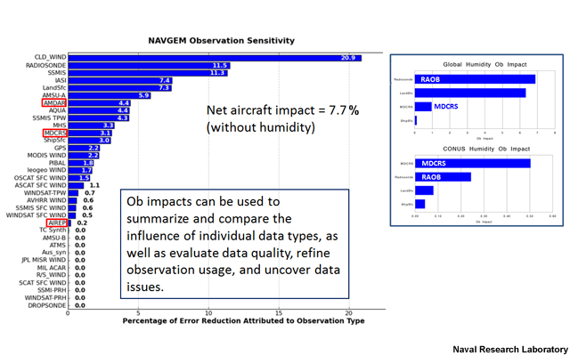
AMDAR data can improve numerical weather prediction forecasts by providing high resolution (in both space and time) meteorological data for parameterizing initial conditions in models. Using various algorithms for comparison, modelers are able to assess the influence of individual data types. In this comparison for NAVGEM, the combined effects of AMDAR, MDCRS, and AIREP aircraft observations reduced the model errors by 7.7%.
In data-withholding studies within the U.S. (e.g., Benjamin et. al.), AMDAR reduced forecast errors in wind, relative humidity, and temperature by up to 20 percent, especially for 6 to 9 hour forecasts. Aircraft data had the largest impact of any data source (radiosonde, surface, GPS-Met, and AMVs) on forecast improvement. The skill of regional forecast models is strongly dependent on high-quality hourly observations. In countries with active AMDAR participation, aircraft observations are the single most important data sources for 1 to 12 hour forecasts. Forecast accuracy improves further with additional aircraft data.
Missing AMDAR data matter also. The 2010 volcanic eruption of Eyjafjallajokull in Iceland resulted in the cancellation of many flights across the Atlantic Ocean and Europe. With the loss of AMDAR data, European Local Area Models suffered dramatic loss of forecast skill due to this lack of data.
Talk to a Meteorologist » How can AMDAR data be used in forecasting?
Forecasters around the world report that AMDAR observations are very useful for several aviation applications, including updating short-term forecasts during rapidly evolving events; identifying areas of turbulence; refining 2000-ft wind forecasts in the TAFs; and determining freezing levels during various events. Forecasters also use AMDAR data to determine the depths of inversions and the strength of winds likely to reach the surface when fog is anticipated.
In 2009 KLM Royal Dutch Airlines and the Royal Netherlands Meteorological Institute carried out a year-long study of the benefits from using AMDAR at Amsterdam-Schipol Airport. In one example, the forecasters reported that the data helped them improve on a model forecast that called for an ice storm to affect the airport. The model had predicted a deep, cold layer near the airport while the AMDAR data indicated that temperatures stayed warmer. The data led the meteorologists to refine the forecast for snow, rather than ice, and improved the accuracy of the timing of transition from rain to snow.
In convective storms, tropical weather systems, and other events where conditions change rapidly, AMDAR has helped forecasters refine the timing of forecasts for weather impacts to aviation operations. These include frontal passages and associated wind shifts at the airport, and the potential extent of wind fields for tropical cyclones. AMDAR has also provided forecasters with better information for estimating the depth of the inversion boundary layer in fog events.
Our expert meteorologists offer these perspectives on using AMDAR data in forecasting:
Rich Mamrosh, U.S. National Weather Service
Show/Hide Transcript
The National Weather Service forecasters, and other forecasters, too, have found a great deal of applications for AMDAR. Some of the most striking ones, around 20 years ago, were for precipitation type of winter storms. In the past, all you really had were surface observations and then radiosondes spaced very far apart at every 12 hours. Now we've got soundings that are coming from aircraft maybe every several minutes at hub airports and you can tell how the temperature structure is changing say 1,000, 2,000, or 3,000 feet above ground. That's the determining factor as to whether you get a snow storm or a rain storm or a sleet storm. Other applications we use quite often are for determining convective initiation and dissipation of storms. In the summertime, a lot of times we know the atmosphere is suitable for convection but you need either trigger or you need to reach a certain temperature in order to trigger convection. So, you can look at the AMDAR soundings and see how a capping inversion is dissipating or whether a layer is moistening or not. You can often determine whether convection will form down to maybe 30 minutes or an hour. Other applications are in fire weather because if you've got water vapour data, you can use that for the different fire weather indices. Aviation forecasters use it for ceiling and visibility forecasts. It can be used for determining layers of icing and also for either convective wind shear or also clear air turbulence. And it's also used quite a bit in Marine forecasting where you can tell whether a layer is stable or unstable over a water surface and then you can determine how much wind will mix down and how it will affect the resulting wave.
Rick Curtis, Southwest Airlines
Show/Hide Transcript
We use the data from the airplanes in many ways. It can be anywhere from helping us to continually monitor the stability of the atmosphere, to looking at the amount of moisture in individual layers of the atmosphere. We can even look at the temperature profile of the atmosphere to determine precipitation type, especially during winter weather. So we use this data in some form or fashion on a daily basis all year round. So again it impossible to overstate the quality of this data being reported to you in near real time in between the balloon soundings and its use with operational planning.
Here are some thoughts on how AMDAR data can help with forecasting low-level wind shear or precipitation transitions:
Nicolas Major, Meteorological Service of Canada
Show/Hide Transcript
AMDAR is used in, in several occasions and specifically trying to identify situations where low-level wind shear can occur. So, this type of report will show various winds according to height. It will give us the information as to where the wind shear is occurring or if there is a wind shear. We also like to use that kind of data in situations where there is a transition in precipitation, especially in the winter where you get that overrunning warm layer of air in the atmosphere that will create some freezing rain. So, you want to be able to time exactly when the freezing rain is going to be in a region or over an airport. AMDAR data will help you identify where the warmer layer of air is relative to the NWP model.
Listen to this viewpoint about AMDAR's benefits:
Dr. Olli Marius Turpeinen, Aviation Consultant
Show/Hide Transcript
As we discussed previously, some of that data is similar in nature to the data from radiosondes. If you use AMDAR data like upper-air data, it is fed into numerical weather prediction models and has, in my view, a very similar role as the conventional upper-air state.
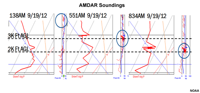
Talk to a Meteorologist » How can AMDAR data be used in forecasting? » Example: Anchorage Wind Shear Case
On 19 September 2012, meteorologists at the Alaska Aviation Weather Unit used AMDAR to monitor the lowering of strong southeast winds aloft, affecting operations at Anchorage International Airport. The lowering winds created over 60 kts of wind shear in the lowest 2000 feet.
The winds aloft increased in speed and lowered from 4500 feet at 1:30 a.m. to 3000 feet at 5:51 a.m. By 8:34 a.m., the strong winds had lowered to 2200 feet and directional shear was also apparent. AMDAR was particularly important in this event because radiosonde data didnt provide sufficient temporal resolution to monitor the rapid onset and evolution of the low-level wind shear.
Talk to a Meteorologist » How can AMDAR data be used in forecasting? » Example: San Diego Ceilings/Visibility Case
In another example, meteorologists in San Diego, California, USA, used AMDAR data for their fog forecasts for six airports in their area. The locations of the airports are shown in the map below.
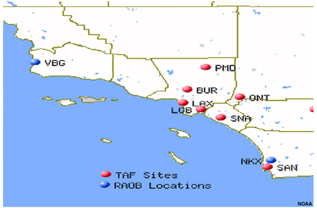
Here is the 2324 UTC TAF issued for the Ontario (ONT) airport:
TAF
ONT
KONT 302327Z 010024 26015KT 5SM HZ SCT250
FM0400 25005KT 5SM HZ SKC
FM0600 VRB03KT 5SM BR SKC
FM1300 VRB03KT 2SM BR HZ SKC
FM1900 26009KT 4SM HZ SKC FM2200 26015KT P6SM SKC=
The TAF suggests that visibilities will drop as low as two miles overnight though skies will remain clear. The key question is whether the inversion will be deep enough to extend over the hills and reach the inland valley where the Ontario airport is located.
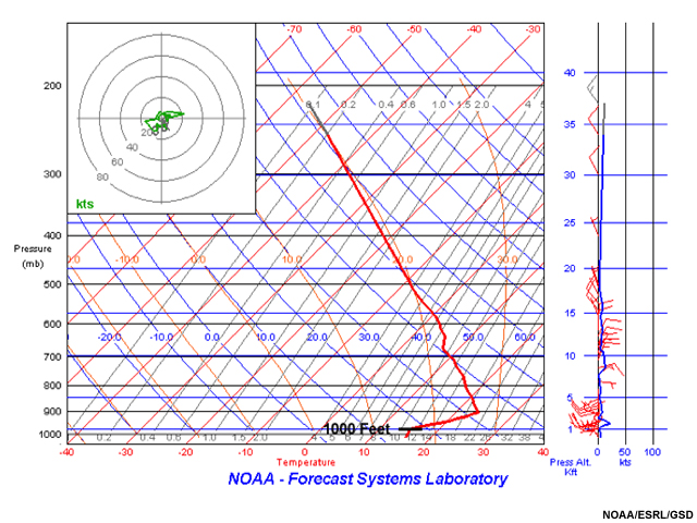
0232 UTC
0201 UTC
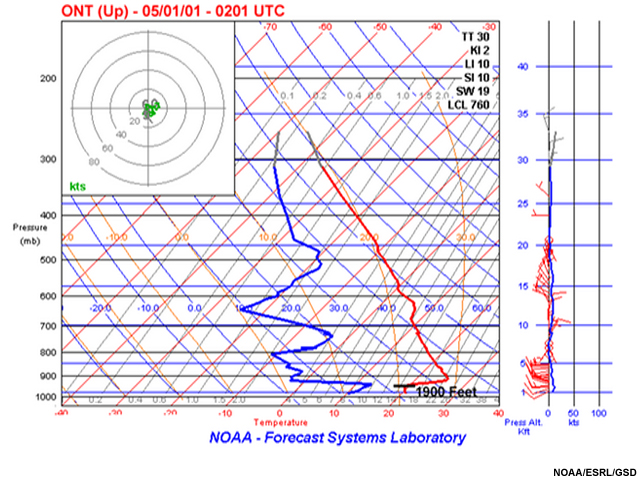
Review the May 1, 0232 UTC AMDAR sounding from Long Beach (LGB), California and 0201 UTC sounding from Ontario (ONT), California. Note that in the 0232 UTC AMDAR sounding from Long Beach (LGB), California, the inversion height is near 1000 ft, and in the 0201 UTC AMDAR sounding from Ontario (ONT), California, the height of the inversion is near 1900 ft.
The height of the terrain in the Ontario, California, area is approximately 1500 feet. Given this value, does the information from the AMDAR soundings suggest that forecasters should update or change the ceilings and visibility values for the Ontario (ONT) airport?
The correct answer is a.
Updating the forecast to account for reduced visibilities is the correct choice. The AMDAR soundings suggest that moist marine air has already reached the inland valley of the Ontario airport and the inversion will lead to lowered ceilings and reduced visibilities in the airport vicinity. Forecasters at the U.S. National Weather Service in San Diego issued a 06 UTC TAF for IFR conditions with ceilings as low as 500 ft and visibilities around one mile. This information is extremely important to aviation operations as very low ceilings and visibilities can restrict traffic arriving at and departing the airport. In this situation, the AMDAR data provided timely information to help forecasters make the appropriate updates to the TAF.
Talk to a Meteorologist » How can AMDAR data be used in forecasting? » Example: Effect of AMDAR in Dispersion Modeling
AMDAR data can also support local incident response applications. The following example illustrates the benefits of including AMDAR observations in the HYSPLIT dispersion model. This model was run to simulate the dispersion of a pollutant over the city of Miami, Florida, USA. The model was first run using the 12 km North American Mesoscale Forecast System (NAM) predictions; it was run again with temperature, dewpoint, and wind information from AMDAR sensors on aircraft in the area.
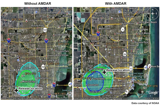
Look at the two images for the first two hours of the forecast. Note that in each image the release location (indicated by the black symbol) of the hazardous material is the same. The maps themselves have slightly different boundaries. Based on the model projections, select the statement below that best describes the expected dispersion.
The correct answer is c.
The model run without AMDAR data projected that the pollutant would disperse to the northeast, over a populated region of the Miami area; the run with AMDAR data suggested the dispersion would be to the southwest. Had this been an actual event and the run without AMDAR data was used, forecasters and emergency managers might have warned the population northeast of the source while the pollutant would have been more likely to disperse to the southwest, over less-populated areas. In this case, the HYSPLIT run with only NAM input could not accurately account for the weak sea breeze that reached the area. The inclusion of AMDAR data allowed the weak sea breeze to be correctly simulated in the dispersion forecast.
Talk to a Meteorologist » How can AMDAR data be used in forecasting? »
Aircraft sounding data illustrating low-level winds. Without the AMDAR data, the very weak sea breeze affecting Miami in the late afternoon was omitted from the model, leading to very different output from the HYSPLIT model in the first two hours.
Talk to a Meteorologist » How can the data be used for climate applications?
As of 2014, over 3,000 aircraft report AMDAR data during their flights. The high quality data are being archived for use in weather [re]analysis. In addition, these data are very useful for climate research. One of the reasons for AMDAR's usefulness in climate applications is the data's high resolution, which provides climatologists the opportunity to analyze the thermal structure of the atmosphere, particularly its longitudinal variation on global scales. Most importantly, AMDAR offers a significant data set for monitoring the effects of climate change, first because it provides high quality in-situ measurements of critical climate variables and second, because it provides high resolution global coverage of them.
Water vapour has distinct radiative properties. Its concentrations can be measured by AMDAR. These measurements are particularly relevant for climate applications, as variations in water vapour in the 9-12 km altitude range (the nominal flight levels of most commercial airlines) can have a significant effect on outgoing infrared radiation, and therefore on climate. Because of their high quality, aircraft-based observations have the potential to be more widely used as a source of climate data, particularly if the water vapour measurements become more global in deployment.
Another climate related issue is the production of cirrus-like contrails by aircraft. Contrail production is caused by a combination of (low) temperatures and (super)saturation. Cirrus clouds block radiation; if the outgoing energy is trapped in Earth's atmosphere it contributes to global warming. Water vapour and temperature data can be used to get an indication of potential contrail conditions. When certain criteria are met for contrail production, the aircraft could directed to another altitude, where production is less favoured. Note that this capability is not yet an operational service but has potential as a beneficial future application.
Talk to a Meteorologist » Can AMDAR data help verify forecast products?
Frequent AMDAR observations are used in verifying NWP forecasts and updating short-term forecasts. A year-long study of the benefits of using AMDAR data at Amsterdam-Schipol Airport reported that AMDAR data was successfully used to determine the presence or absence of cold air layers predicted by a short-term forecast model.
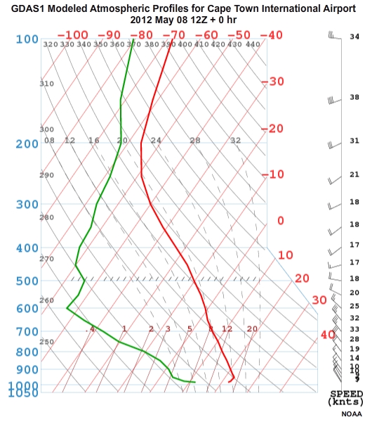
Consider this case from Cape Town, South Africa. The GDAS1 model profile for 12 UTC suggested there could be an inversion favouring fog formation in the Cape Town Bowl. Looking at the AMDAR data, it became clearer to forecasters that conditions would support fog development overnight, with dense fog persisting until around sunrise.
Model
AMDAR
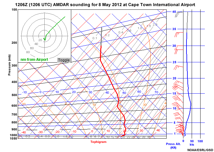
Available AMDAR data confirmed the development and overnight strengthening of the inversion and provided forecasters with necessary information to better estimate fog start and end times. Knowledge of these timeframes helps airlines be more proactive in planning for reduced visibility conditions that affect flight operations.
Hear what these meteorologists say about using AMDAR to verify forecast products:
Rich Mamrosh, U.S. National Weather Service
Show/Hide Transcript
Its probably more typically used to verify model forecasts. For example, say you're looking at the NAM three-hour forecast of an 850 mb temperature because youre concerned about precipitation type. You can overlay that three-hour temperature forecast at 850 with AMDAR temperature data from that same level and determine whether the model is performing well or not. As far as verifying forecasts, we often use it to verify forecasts of low-level wind shear at airports. For example, if we put in a terminal forecast that low-level wind shear will begin, say at Kennedy Airport in New York at 0600Z and there will be wind shear at 1,200 feet, we can look at arriving or departing aircraft at that time and then see if low-level wind shear is actually present or not. So, we can actually verify aviation forecasts of low-level windshear and icing with the AMDAR data.
Rick Curtis, Southwest Airlines
Show/Hide Transcript
We use AMDAR data quite a bit not only for verification purposes but also for our forecast confidence purposes. When we produce a forecast, once it's out there you can't reel it back. But before you send it out there, you obviously want to use every tool at your disposal to validate and improve your confidence in your forecast. So what we do is, once a forecast is issued, we're continually monitoring surface and atmospheric data to make sure that those forecasts come to play out the way that they were intended to play out. If for some reason they're not similar to the AMDAR data, it allows us to more quickly ascertain that the forecast needs to be updated. The forecast needs to be changed because of this real time state-of-the-atmosphere information that we didn't have access to before. It's just another tool, it's another set of data that is used to continually verify the quality of the forecast. It's okay to change the forecast -- the hard thing is to change it as soon as it needs to be changed.
Talk to a Meteorologist » What benefits do AMDAR water vapour data offer?
Water is one of the most important contributors to the energy budget and balance of the atmosphere. It plays a role in the transfer of energy from solar to thermal and kinetic energy and affects the temperature of the atmosphere. Despite their importance, accurate measurements of water vapour at high time or space resolution are not always available. Dr. Peter Steinle from the Bureau of Meteorology, Australia indicated: In comparison with temperature and wind data, moisture observations suffer from poor data coverage, there is minimal related data, and the modeling of moist processes is widely acknowledged as much weaker in numerical models than general temperature and wind fields (WMO, WIGOS Technical Report 2014-1, p. 18).
In locations where AMDAR water vapour data are available, incorporating the atmospheric distribution of water vapour measured at frequent intervals into numerical weather prediction models can improve the forecast accuracy. Water vapour data from cruising altitudes can improve the accuracy of global NWP models over AMDAR-equipped regions.
Water vapour measurements allow AMDAR to be a "complete" upper air observing system by providing the same parameter set as radiosondes. Higher horizontal and temporal resolution measurements of water vapour have been shown to have a significant positive impact on the accuracy of numerical weather prediction forecasts. This is particularly true for weather events in which water vapour is key, including fog, convection and thunderstorm development, precipitation, and icing conditions. Because these are the same weather phenomena that tend to impact the airlines and lead to increased costs, it is in the airlines interests to help meteorological services improve forecasts for these events.
Here are some perspectives about the benefits of the water vapour sensor:
Rich Mamrosh, U.S. National Weather Service
Show/Hide Transcript
The water vapour data that are a big boon to AMDAR because that's probably the one really big missing piece of the puzzle when you're trying to determine not only whether it'll rain or not but whether you'll have heavy rain or whether you'll have rain or snow or whatnot. Often in the summertime you've got broad areas of the country that are conditionally unstable and where thunderstorms could form or, or maybe not. And a lot of times they are relatively narrow like rivers of moisture in the atmosphere at different levels. And, if you knew where they were located, you'd be better able to forecast where convection would develop. But, the very coarse nature of the radiosonde network has never really afforded us that ability to know where these narrow rivers of moisture are located. As we get more and more aircraft that have water vapour sensors, we're going to have an increased ability to forecast where convection will develop and where it won't and the model performance will also improve.
Rick Curtis, Southwest Airlines
Show/Hide Transcript
Water vapour is the missing element to help fill in. We've had the temperature and wind available to us for years and now that we have a greater coverage of water vapour airplanes flying around it really helps a lot because it provides that full sounding with complete wind, temperature, and humidity information. So, it really makes this program complete. Southwest is up to 87 aircraft flying with water vapour sensors now. We're on board to install another 20 aboard our aircraft here in the next few months and UPS has it on 25 up there now. I know that there's plans from the weather service to increase the coverage even more. So it really completes the picture because it allows you to see the various moisture profiles in the atmosphere that before you were only getting from the balloon soundings. Now with water vapour you're able to get that not only more frequently but certainly at high resolution and very quick reporting times especially around major airports of significant airline activity.
Listen as an airline meteorologist discusses the advantages of water vapour data for fog forecasting, storms forecasting, and winter weather:

Randy Baker, UPS Airlines
Show/Hide Transcript
There are a number of aircraft safety benefits from AMDAR data. Some airlines report turbulence, but we don't. All airlines report temperature and winds and then in addition we report water vapour data. And this water vapour data is very good. We initially got into this because fog forecasting is a big issue for us as a cargo airline. We operate into a number of airports right around sunrise, right when fog is the most likely to occur. And so we recognized early on that water vapour data would be very valuable to produce better fog forecasts. And so that's something we've concentrated on. But water vapour data is also valuable for forecasting thunderstorms. We'll take a look at our aircraft data to calculate what the convective temperature is to see what sort of convective inhibition may be present. Severe weather potential, that sort of thing. And then in winter time, this water vapour data is valuable in forecasting winter precipitation types such as snow, ice pellets, freezing rain. And then another general area that I've seen on forecast discussions, frontal wind shears show up well in AMDAR data, when there's a strong warm front for instance and you get the strong low-level jet that's causing low altitude wind shears. So those are some of the safety benefits of AMDAR data.
Here is another perspective on the importance of humidity data:
Dr. Olli Marius Turpeinen, Aviation Consultant
Show/Hide Transcript
I think that this is an important point because there are certain parameters for aviation that are very important - icing and the development of convection in particular. Of course, you need to have humidity data for the numerical weather prediction models to correctly forecast these phenomena. I think that in the early days of AMDAR, one of the drawbacks was the fact that there was no humidity data. So, I think that in order to be in the same league as the traditional radiosondes it is important to have that data. It's important in particular for aviation, that humidity is included as one of those parameters that are being updated through AMDAR.
Talk to a Meteorologist » Test your knowledge
Check what you have learned after your meeting by answering these questions.
Question 1
Based on what you learned from your research so far, what are some of the reasons to consider implementing AMDAR in your area? Select all that apply.
The correct answers are b, c, d.
The AMDAR program provides a cost-effective way to gather observations over the long term. Over busy airports, forecasters will have access to observations as often as equipped planes take off or land. The in-flight upper air observations are also another benefit of implementing the AMDAR program. While access to AMDAR data will provide additional information to forecasters, it does not guarantee that forecasters will be able to quickly derive improved forecasts based solely on these data.
Question 2
Which of the following statements are attributes of data produced by the AMDAR program? Select True or False.
The correct answers are shown above. AMDAR data have a low cost (around $15) per profile compared with the $300 per profile for radiosonde data. AMDAR data are reported to within +/- 1.0 °C for temperature measurements, wind vectors within +/- 2-3 m/s; and pressure altitude within +/- 4 hPa, well within WMO requirements. Malfunctions of the AMDAR sensors are rare and observable via deterioration of data quality. They are quickly repaired as part of regular aircraft maintenance.
Question 3
What would be the most noticeable impact of adding AMDAR data to NWP? Select the best answer.
The correct answer is b.
The most noticeable impact of adding AMDAR data to numerical weather prediction is improved temperature forecasts in the upper troposphere. The observed error reduction is between 15 and 20%. The addition of AMDAR data hasnt been shown to substantially improve precipitation, surface temperature, or five-day upper troposphere wind speed/direction forecasts in all cases.
Question 4
The 24-hour numerical weather prediction forecasts for which weather phenomena benefit substantially from the use of AMDAR data? Select all that apply.
The correct answers are a, b, c.
Answers a, b, and c are correct. Wind direction and speed near the surface, potential for freezing precipitation and areas of turbulence are all forecasts that benefit greatly from the use of AMDAR data. Smaller improvements in rain forecasts are possible based on atmospheric stability data and water vapour data provided by AMDAR.
Question 5
What are the meteorological benefits of placing water vapour sensors on aircraft? Select True or False.
The correct answers are shown above. The use of water vapour sensors on aircraft will assist us in better understanding the energy transfer and balance of the atmosphere as well as improve NWP forecasts over regions with AMDAR data. Water vapour data would provide useful climatological record for examining changes resulting from greenhouse gases. Water vapour is not a major contributor in the modeling of winds near the surface.
Talk to an Airline Representative

Lorretta Rossi
After researching the adoption of AMDAR by airlines, you find that as of December 2014, several airlines were actively participating in sharing their aircraft-based observations. For a full list of AMDAR participating airlines, see: WMO List of AMDAR Participating Airlines
You are meeting Lorretta Rossi from one of the airlines. You are curious to learn more about how AMDAR is helping them in operations. Ms. Rossi has also asked some of her colleagues to share their perspectives about using AMDAR.
Which question would you like to ask?
Talk to an Airline Representative » What safety benefits can be gained from AMDAR data?
The main safety benefit of AMDAR comes via improved forecasts and more accurate information about the timing and location of potential severe weather. More accurate forecasts give flight dispatchers more confidence in the onset, intensity and duration of any weather issues. This information can feed directly into their flight planning, so that air traffic managers, aircraft, and crews can be prepared for any possible weather and can receive flight routing information to help them safely and efficiently complete their flights.
Airlines can receive prompt feedback about the quality of the data coming from aircraft sensors. In one instance, a meteorological service noticed a temperature sensor giving faulty readings and notified the airline. The airline staff quickly corrected the problem. This feedback helps airlines keep their sensors in top-operating shape. They can proactively deal with potential issues that could lead to instrument or relay failures and ensure there are no disruptions to receiving timely data.
Listen to these thoughts on the benefits of AMDAR data for airline safety:
Rick Curtis, Southwest Airlines
Show/Hide Transcript
Safety is largely governed by regulation obviously, and any carrier wants to have the most safety practices in place. That being said, AMDAR data is another tool that we use in addition to radar, in addition to SIGMETs, in addition to all the other aviation products at our disposal in being able to plan the route of flight for that aircraft in the most safe and the most efficient way possible. So as far as how AMDAR itself would aid to that, it's tough to say that 'because you have this then you know you're going to be safer.' However, it is safe to say that the AMDAR data is being as important as it is because it's the only source of pretty near real-time upper air information. If we need to make adjustments to our current thinking AMDAR gives us the ability to do that much quicker than with what we would have had available without it.
Here is another perspective:
Dr. Olli Marius Turpeinen, Aviation Consultant
Show/Hide Transcript
What about the safety benefits for aviation? It is very important, again, that we put the AMDAR data in perspective. It is a very important component of the basic data. If we did not have basic data, we couldn't possibly undertake any aircraft operations. And AMDAR data has the particular character that you get information from areas where you would not get any data otherwise. So, I would personally rather emphasize the positive impact of AMDAR data on the efficiency of flights. In other words, that the aircraft are able to select the optimum routes and that saves fuel. So, I think that is the most important. Of course, you can also say that the forecasts of some of the hazardous phenomena has improved through the use of AMDAR data in the numerical weather prediction models. So you can say that in that respect, yes there can be an indirect safety benefits for aviation.
Talk to an Airline Representative » What safety benefits can be gained from AMDAR data? »
Talk to an Airline Representative » How can AMDAR improve flight operations?
AMDAR data offers specific advantages for improving flight operations during a variety of weather events. Here are some examples:
- AMDAR provides crucial information about fog forecasting. The main airports get timely information about the onset and break-up of fog, and forecasters are able to make better estimates of the depth of the fog layer.
- AMDAR data aid winter de-ice forecasts. For example, if planes dont need pre-icing treatment, there can be significant cost savings.
- Getting more accurate estimates of precipitation type (rain, freezing rain, ice), frost, thunderstorm potential, and turbulence helps airlines prepare appropriately and minimize the impact of those events.
- The same improvements are true for wind forecasts. Forecasters find that AMDAR data improves the model initialization which translates to better model forecasts and more streamlined airline and air traffic management operations.
- One of the largest safety benefits comes from improved identification of low-level wind shear environments at airports: changes for runway assignments can be anticipated if there are better forecasts of the wind change time window, allowing the airport to plan and instigate operational changes.
There are also several potential improvements to aircraft performance that could result from the use of water vapour sensors. Inputting water vapour data to engine management systems could improve the fuel efficiency of the engines (WMO, 2014) and could also result in improving the prediction of possible icing conditions and judicious use of de-icing equipment.
UPS meteorologists used AMDAR data to determine which coastal airport to divert their aircraft to as fog formed over their original destination. Using AMDAR data, the meteorologists determined the depth of the marine layer and were able to pass along information to allow their pilots to safely land at an alternate airport.
Listen as an airline meteorologist discusses the advantages of AMDAR data for flight planning:
Randy Baker, UPS Airlines
Show/Hide Transcript
AMDAR data really helps improve flight operations, mainly for flight planning. Especially when you consider that the 0600Z and 1800Z global forecast runs really are only possible with the AMDAR data since there are very few balloon soundings at those times. So that provides much better winds for our flight planning process. And when you have more accurate wind forecasts, that means you have more accurate fuel burns and more accurate times from departure to destination. Another situation that occasionally arises, is for a flight to report stronger than forecast headwinds and there, they have higher fuel burns than they anticipated. They're getting to the point where if the wind doesn't change they may have to land short to take on fuel. And so in those situations we'll take a look at the wind reports from other aircraft in the vicinity and try to figure out what altitude would be a better altitude for them to decrease those headwinds. So there have been several situations where this has occurred and we are able to give the flight a different altitude and they were able to continue on to destination as planned.
Here is more about AMDARs role in flight planning and strategic operations:
Rick Curtis, Southwest Airlines
Show/Hide Transcript
In many ways, in day-to-day operations you can use AMDAR data to supplement your flight planning in terms of routing and fuel planning, in terms of avoiding the weather as much as possible. Also it can be used on a strategic basis. For example, if you're going to have mixed winter precipitation issues in a southern city, being able to monitor the state of the atmosphere in terms of temperature profile to determine what type of precip it's going to be is important. The huge difference in de-icing capabilities, in runway clearing capabilities in southern cities--those kinds of things associated with different types of precipitation types will assist in planning. So if we know that there's going to be a freezing rain event versus a sleet event versus a rain event versus a snow event, and can determine that ahead of time at an individual location. (Particularly a southern city where they have less resources to work with as far as de-icing equipment, de-icing inventory, runway clearing equipment, that sort of thing.) We can use that information to help us manage how many airplanes we're going to be sending into those places. Do we need to throttle our arrivals, do we need to cancel, do we need to take other proactive type measures around operations for that airport for that day. The data comes into play in so many ways. In short, on an operational level it's useful from fuel and routing information. On a strategic level, knowing what your operational abilities are going to be in a given place in a given time because of tremendous volume of aircraft that are going to be flowing in and out of an airport, any help that you can get up front to make those decisions is going to help you do a better job at the end of the day.
Here are more thoughts about AMDAR's role increasing efficiency in flight operations:
Dr. Olli Marius Turpeinen, Aviation Consultant
Show/Hide Transcript
I mentioned before, that AMDAR data are like any basic data - soundings, satellite data, and so forth. Their most important role is in efficiency. And so, for flight operations, you can have the more direct routes, or better routes as far as the weather is concerned, optimum wind and temperature conditions. And, certainly if you have more data that is being used in the numerical weather prediction, that produces the aeronautical forecasts, certainly you will have improved efficiency and reduced costs and so forth. So, very important indeed.
Talk to an Airline Representative » What operational cost savings can be realized using AMDAR?
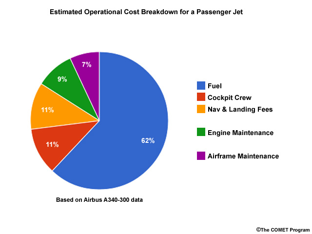
South African Airways (SAA) completed a cost savings analysis based on participating in AMDAR and found that the returns far outweigh the costs of participating. They estimated $2-3 million/year in fuel savings from improved flight planning based on the availability of more current weather data. These savings add up quickly because fuel costs account for over 60% of an airlines operating cost.
Participation in AMDAR gives airlines the capability of finding more efficient flight paths, which translates to time savings as well. According to the SAA analysis, if the increased frequency of weather data allows them to save just 1 minute per sector, then over a year, they can save 221 hours of flight time. Reducing flight hours also translates to savings on maintenance and engine/airframe costs.
For specific weather events, the savings garnered through AMDAR participation may vary. For instance, AMDAR data can help airlines determine when/if de-icing is needed. UPS estimates that a single improved frost forecast saved their airline several thousand U.S. dollars in de-icing costs (Baker, 2014).
Upper-level wind data can also be used to locate fuel-saving flight levels. In this example, taking advantage of the winds can make it a quick flight from Oklahoma City, Oklahoma (OKC) to Buffalo, New York, (BUF).

An airline meteorologist discusses operational cost savings, including a single-night frost forecast example that saved the airline $15,000:
Randy Baker, UPS Airlines
Show/Hide Transcript
Operational cost savings from AMDAR - it's difficult to quantify them because you have to quantify avoidable weather delays as opposed to just normal everyday weather delays. And one way to think of this, you have to have a good forecast to start with but you also have to understand the operational impact. If you don't understand the operational impact, there's no way that you can really make an effective decision. But, even when understanding the operational impact is present, that still has to be communicated effectively to decision-makers so that they make the right operational changes to reduce the impact and cost. You also have to look at the cost of doing nothing versus the cost of taking action. So, it is a very difficult thing to quantify that. However, I do have one example. One night, we had low stratus behind a midlatitude storm system that had moved past our airport in Louisville. And, we were under the low stratus but expecting to clear out because the edge of the clouds were clearing from the northwest and not that far away from Louisville. And, for us, frost is a big deal. It costs us approximately $30,000 dollars to pretreat the entire fleet for about 100 departures in the early morning hours for frost. So, this particular night we were expecting it to clear so we had a forecast out for frost. However, one of the first aircraft that landed that night around midnight, was a water vapour aircraft. And, we noticed that the winds in the cloud layer had switched from the northwest to out of the south, which told us that the cloud bed was not going to clear us. It stopped advancing to the south and was actually turning around heading back north. So, based on that, we were able to call over to the de-icers to tell them to call off the pretreating for frost. And so, you know, we probably saved about half of that $30,000. We probably saved about $15,000 by canceling the pretreating for frost that night for our departures.
Listen to another discussion of cost savings in both strategic and tactical planning environments:
Rick Curtis, Southwest Airlines
Show/Hide Transcript
The largest cost savings would be in the strategic decision making, so whether or not we can operate any particular airport for a particular day, what hours can we operate based on winter weather or based on strong thunderstorms moving through that airport. All those things are huge in terms of operational dollars in a strategic environment. On a day-to-day tactical environment, it's probably not as great except for the fact the data is fed into the models that go into the flight planning system. So once it's in the flight planning system you're obviously going to get better wind and temperature forecasts that are used in flight planning. So that's really the benefit there but I would have to say that in my mind the stronger benefit is just the operational gain that we get from a strategic planning initiative if you will, by being able to take proactive action where it's needed.
Here is an additional viewpoint on operational cost savings:
Dr. Olli Marius Turpeinen, Aviation Consultant
Show/Hide Transcript
That's exactly what I previously mentioned, that because of your improved forecasts and better optimized routes, you will need to carry less fuel so you will have cost savings and not only because your route is optimum but also you do not need as much reserved fuel on board. So, altogether, yes it's an efficiency issue and at the end of the day, it can lead to cost savings.
Talk to an Airline Representative » How does improved weather forecast skill affect airline operations?
When forecasters use AMDAR data, accurate and specific forecasts for severe weather can help airlines be prepared so that unplanned and costly deviations can be avoided. Knowing the timing and location of turbulence can help in determining safer flight routes. Improved weather information, particularly concerning the onset and duration of an event, will help airports and traffic managers be able to anticipate traffic flows and take appropriate steps to prepare the airport and alleviate flight delays.
An airline meteorologist explains AMDAR data benefits for air traffic management:
Randy Baker, UPS Airlines
Show/Hide Transcript
AMDAR supports air traffic management, in the winter time especially by providing better winter forecasts for the major hub airports. That's where airlines really have to concentrate. For us, Philadelphia, Rockford, Louisville, those are the main hubs in the northeast. Dallas to a lesser extent but when they have a major ice storm, it really impacts operations and so we have to forecast those things accurately. So, winter storms are big in the wintertime. In summertime, thunderstorms are the big operational impact producers. And one thing we have noticed, the models are getting better with thunderstorms. We've noticed the HRRR, the high resolution rapid refresh model, is starting to do a fairly decent job at forecasting thunderstorms going out to the first 6 to 12 hours. And that's a direct benefit of having AMDAR data feeding a model that updates every hour.
Additional benefits can be realized through installing water vapour sensors. Having high temporal resolution moisture profiles will help forecasters better predict air hazards like fog, snow, freezing rain, thunderstorms, or in-flight icing.
Here are some thoughts about improved forecast skill:
Randy Baker, UPS Airlines
Show/Hide Transcript
Improved weather forecast skill - I am going to separate that into two separate areas. Number one, if you have better data feeding the models, in other words better initialization, you should have better forecasts. And so that's direct forecast skill in the model and that affects everything. It affects the terminal forecast at a location. It affects forecast intensity of the storm, whether it's a snowstorm or thunderstorm line, that sort of thing. So, with that hopefully you get better timing and you make better decisions. The second part of it, going back to my previous description of the whole process of making operational decisions, when you have a good forecast you still have to understand the operational impact and then communicate that risk effectively to the decision-makers so that they make the right decision. If you don't make the right decision, you can actually increase the cost rather than decrease the cost.
Listen to another viewpoint about forecast skill:
Rick Curtis, Southwest Airlines
Show/Hide Transcript
Improved skill is something that is always sought. It's very difficult to do. It's very difficult to quantify. Sometimes with weather forecasts it's hard to see the individual gains because of the variability on a day-to-day basis of the quality of forecasts because weather prediction is not an exact science. So you have good days and you have bad days, if you will, in predicting weather. And overall I think everybody realizes that the overall quality of the forecasts are improving and they improve a lot due to tools like AMDAR data getting put into the models and tools like AMDAR data being used operationally especially by the National Weather Service in their TAFs. But again AMDAR is still just another tool into the whole mix of products and tools that everybody uses to put together the forecast. So in short AMDAR is certainly an important tool but it's really hard to put a dollar value. To say that because you have AMDAR data, you're going to get this much benefit from forecasts on the back end just by having that one input. Unfortunately that's what everybody wants--to be able to justify the AMDAR data more and more. We know it's a benefit and we know it certainly helps things out. It's just very, very hard to quantify that because really you're not entering a new datatype into the equation, what you're doing is you're providing an existing data type but you're providing it much more often and in much higher temporal resolution than what you had before. So really all you can do to quantify that is just compare the models without it and the models with it and then compare whether or not the results are the same or are they different--how much better or how much worse if you will would that be.
Rick continues with an example from his Southwest Airlines experience:
Show/Hide Transcript
We can come up with an example from yesterday. Yesterday, we had the ability to continually monitor the atmosphere in both Chicago and Denver with the thunderstorms that were predicted to roll through those two stations of ours. After Chicago had their first round of storms we were able to continually look at AMDAR data and see that the atmosphere had stabilized from the earlier storms and basically what was happening was the next set of storms that were ready to move toward Chicago were running into that stable atmosphere and weakening as they approached. So we were able to keep going and keep sending aircraft in there and not have to meter anything because we could handle a full load of aircraft with a rain event versus with a thunderstorm event. With thunderstorms we would have much less throughput because of a range of things: ATC delays to ramp delays with the lightning concerns to what have you-- a lot of different things occur during thunderstorm operations that do not occur doing simple rain type operations. So yesterday we were able to really gain value out of those near real-time monitoring of the atmosphere near Chicago. In Denver yesterday it was a little bit different of a situation. We went from a thunderstorm day to basically a severe weather thunderstorm threat and over the course of the day we watched the atmosphere in Denver get progressively more unstable and reach some critical values in terms of indicating severe weather may be a greater threat than what we originally thought in the morning.
Here are some additional comments about how AMDAR benefits flight operations and planning:
Dr. Olli Marius Turpeinen, Aviation Consultant
Show/Hide Transcript
Generally speaking, I would say that we are talking probably about three quarters maybe even more, comes from efficiency. In other words, you get the improved forecast, improved flight planning, better routes, optimized conditions. But, of course, you can avoid hazardous weather phenomena so there's certainly a safety issue. But I think that for the vast majority of operations, the improvement can be realized in terms of efficiency and fuel savings.
Talk to an Airline Representative » What are the benefits of AMDAR in-situ turbulence data?
Some AMDAR-participating airlines are equipped with algorithms to compute eddy dissipation rate (here termed EDR, defined as the cube root of eddy dissipation rate, having units m2/3 s-1) from available onboard flight parameters. EDR is a "stateoftheatmosphere" turbulence metric and has been adopted as the ICAO standard for aviation turbulence. Without EDR data, the best truth measurements of turbulence in the atmosphere come from pilot reports (PIREPs), which may be displaced in location and time from the actual turbulence event, and which involve some degree of pilot subjectivity.
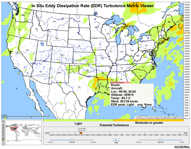
Data viewer showing three hours of EDR in situ turbulence reports (small colored squares - smooth air shown as blue, light turbulence as green, moderate or greater turbulence as orange) and the NCAR Graphical Turbulence Guidance's forecasted areas of turbulence (light turbulence areas shown as green, moderate or greater turbulence as orange).
EDR data can provide guidance for operational planning, helping airlines to identify areas of turbulence and coordinate with Air Traffic Control to utilize smoother flight levels, particularly for trailing aircraft. As of 2014, about 50 Boeing 757 aircraft from United Airlines in the U.S. are equipped with software to downlink in-flight EDR reports at oneminute intervals. To improve timeliness, data quality, and reduce communication costs, an improved algorithm has been developed that downlinks turbulence encounter information immediately if the EDR is above a certain threshold and provides routine reporting at less frequent intervals. As of 2014, this improved algorithm had been implemented on Delta Air Lines Boeing 737700/800s (over 80 aircraft) and 767-300/400s (over 80 aircraft) and also on more than 160 Southwest Airlines Boeing 737-700/800 aircraft.
Talk to an Airline Representative » Test your knowledge
Check what you learned after your meeting by answering the following questions.
Question 1
What is the most important way in which AMDAR data can improve the safety of aviation operations? Select the best answer.
The correct answer is a.
The most important way in which AMDAR data can improve the safety of flight operations is through more accurate forecasts about the location, onset, and duration of severe weather. There is no indication that AMDAR only improves early morning forecasts for heavy snow, nor has it been associated with an increased number of fair weather forecasts. Climatological data can provide a basis for understanding weather in an area but do not specifically relate to the safety of aviation operations.
Question 2
How can the use of AMDAR data improve overall flight operations? Select the best answer.
The correct answer is d.
More accurate forecasts would enable dispatchers, traffic managers, and airport operators to make better decisions on how to manage the incoming and outgoing traffic in the area. AMDAR data will not improve the four- to five-week forecasts that would be required for the flying public to make informed decisions about which day to fly. Shutting down airports and directing traffic through a single area would result in more complicated flight operations.
Question 3
In what ways can the use of AMDAR data in weather forecasting enable aviation operators to save money? Select all that apply.
The correct answers are a and b.
More accurate freezing precipitation forecasts would enable airlines to schedule de-icing crews only when they are needed. Similarly, more accurate airport forecasts would allow flight dispatchers to plan for the necessary amount of fuel and not add fuel for possible alternate airports. While it might be beneficial for airlines to schedule flights on good-weather days and align the air traffic with predominant winds, the demands of the public for regular flights would prevent these things from becoming a reality.
Talk to an AMDAR Systems Manager

Steve Mohalovich
You are meeting with Steve Mohalovich, an AMDAR systems manager, who has helped several meteorological services and airlines implement AMDAR. Mr. Mohalovich has contacted one of his international colleagues to share his perspectives as well.
Which question would you like to ask him?
Talk to an AMDAR systems manager » What on-board systems are required for AMDAR?
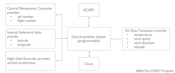
The AMDAR system uses avionics sensors already installed on the aircraft but adds the AMDAR software module to the appropriate aircraft avionics. The software module enables data collection and initial quality control at frequencies appropriate for meteorological applications. The Aircraft Data Computers process and format the data from the onboard sensors, and transmit it using standard communications systems. This keeps the modifications to aircraft systems and avionics to a minimum.
Essentially, the key take-away points are:
- The AMDAR communications currently rely on standard protocols defined for the Aircraft Communications Addressing and Reporting System (ACARS).
- WMO defines the meteorological requirements within its AMDAR Onboard Software Functional Requirements Specification (AOSFRS). The Meteorological Report within the AEEC ARINC 620 specification provides the downlink and uplink formats for configuration of the AMDAR software and transmission of the data.
- The AMDAR software is certified for the avionics and deployed by the airline's maintenance staff or contractors.
AMDAR system schematic.
The gathered observations can be transmitted to a National Hydrological and Meteorological Service (NHMS) in near real-time, although some companies choose to transmit the data once the aircraft has landed. The NHMS processes the data and ensures there are no errors (when there are errors, they report these to the airline). The NHMS also makes the data available globally so that other forecast services get the advantage of using the data to improve forecasts for the wider aviation community and the public.
A basic AMDAR system does not require airlines to install additional sensors. If airlines choose to supplement their data collection with a water vapour sensor, this sensor is low weight and has low cost.
The AMDAR Onboard Software (AOS) is designed to perform the following functions:
- Interface and accept input data from a variety of aircraft avionics equipment;
- Perform basic quality checks on the input data;
- Perform calculations upon the input data to derive required meteorological variables;
- At set intervals, process collected data into standard output messages for transmission to ground stations;
- Accept and process inputs, allowing users to alter the AOS behavior. (WMO AMDAR Observing System resource page)
Because the onboard software requires complex, data-intensive computations, the AMDAR system works better in modern, large commercial aircraft having the proper avionics, data computers, and communication systems. For more detailed information on the meteorological standards for the onboard software, view this page: AMDAR System Standards
Here is a description of how AMDAR software integrates into aircraft systems:

Stewart Taylor, U.K. Met Office
Show/Hide Transcript
The beauty of the AMDAR system is that we utilize existing aircraft infrastructure. This allows the gathering of information in the basic AMDAR message. This message contains information on the aircraft identifier, the time and position, the height, the wind direction and speed, and temperature data using the existing on-board sensors, the computers, and of course the airlink communication system. So, following on from their assessment on data coverage that will have been provided by the identified airline, we send out a questionnaire and this is completed by the contacts within the airline, the avionics, and/or engineering teams. The questionnaire asks some questions with relevance to airline fleets, which aircraft type and series, the onboard avionics. This determines whether the avionics can support the AMDAR software. And, most importantly, if the airline has an aircraft comms addressing and reporting system, ACARS capability. If the fleet is capable of supporting AMDAR, the on-board software is then developed and implemented by the airline. This software interfaces with the avionics and then derives the meteorological variables and, at set intervals, will process the data into aviation-specified messages to the ground stations. It should be noted that the AMDAR software has no impact on the operation of the aircraft and is certified for integration into the non-critical part of the avionics, for example, the airline's aircraft condition monitoring system, the ACMS. If the airline is willing to consider the addition of additional meteorological variables, for example humidity, then this will involve the installation of a new sensor on your aircraft.
Talk to an AMDAR systems manager » What ground systems are required for AMDAR?
As with other voice and data communications required for airline and aircraft operations, AMDAR relies on aircraft-to-ground and ground-to-ground communication systems. Aircraft-to-ground communications in modern aircraft is achieved through VHF radio or satellite communications networks, often provided by the two major data service providers—ARINC and SITA. However, in some countries, such communications systems might be publicly owned and operated. While data can be sent via VHF or satellite networks, some airlines will use only VHF for in-flight data delivery to save on communications costs. In general, the network of European National Meteorological Services (EUMETNET) has measured that 90% of EUMETNET-AMDAR (E-AMDAR) reports are delivered within 30 minutes.
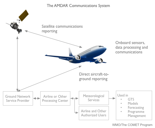
There are multiple ways to set up the ground-based communication network. Ground-to-ground communications can be accomplished through communications companies or the airline. If the data transmission is done through the companies, it usually involves the set up of both hardware and software and possibly a communications link with the company. Occasionally, it could be done through internet transfer protocols like TCP/IPC or FTP.
If the data are transferred between the airline and the meteorological service, the internet-based communication solutions work well. When using internet communications, it is important to consider the reliability of the network and timeliness for delivery.
The main contributor to ongoing costs for the AMDAR program is communications, with air-to-ground communications being the most expensive. The costs are variable and depend on the data delivery arrangement. Generally, AMDAR operators have been able to arrange communication solutions based on low-cost tariffs through the data service providers. Because the AMDAR program is beneficial to both Meteorological Services and the aviation industry, most programs have been established and are maintained based on a cost and resource-sharing arrangement.
Learn more about the communications configurations and data management: The AMDAR Observing System
Listen to more details about AMDAR's communications networks:
Stewart Taylor, U.K. Met Office
Show/Hide Transcript
In addition to the aircraft ground communication via the ACAR system, using VHF, HF, or satellite media, AMDAR's system requires a ground-based comms network. The two main methods of setting up this communication network, enabling the AMDAR data to reach the National Meteorological and Hydrological Services, (the met services). Firstly, the data can be sent directly from the aircraft to the airline ground reception system and then routed to the met service. In experience, some airlines do insist on this. A method of transferring the data to the met service would then need to be agreed and implemented between the airline and the met service. This could involve the setup of both hardware and software applications and the data being routed using an Internet transfer protocol like TCP Over IP (TCP/IP), or FTP. The second method is the airline can agree for the AMDAR data to be addressed directly to the met service with a parallel feed to the airline. This can be achieved through the airline's data service provider, the DSP, for example Rockwell-Collins or SITA, and involve the met service establish a network address and connection with the DSP. In both cases, the data received by the met service would be a Type-B ACARS message format. In experience within European projects, with fourteen airlines that are involved with the E-AMDAR program, it is a mix of both of these methods as some of the airlines route their data directly to the Rockwell-Collins met server in Annapolis and two or three of the airlines within Europe send it direct to the met service for processing. One of the other things to consider is the robustness of any network that's set up and also the data delivery time on this. So the met service is then responsible to develop this ground-based processing system, to receive and decode these Type-B messages. This system will also provide a rudimentary data quality check before reformatting it into bulletins for operational use and exchange on what we call the WMO global telecommunication system, (the GTS). Of note is the ownership of the AMDAR data stays with the airline, unless otherwise agreed. We set up our data license agreement between the met service and the airlines to cover this. The other aspect for consideration within the ground-based infrastructure is ongoing costs for the AMDAR communications. Air-to-ground communication costs are variable and depend on the data delivery arrangement with each airline and their data service provider. These costs will need to be agreed between the airline and the respective national met service.
Talk to an AMDAR systems manager » What additional technical or instrument requirements are necessary for implementing AMDAR?
After several evolutions, a sensor for measuring water vapour content is now available for installation on aircraft. The new sensor weighs only 4.75 kg. The water vapour sensor uses 28 VDC power and can be placed under the forward door on either side of the aircraft.
The installation process has been refined and is estimated to take 40 - 50 hours during a C or D maintenance check. The external air sampler has a low profile and low drag coefficient so it will not impact aircraft operations. Also, it is designed to minimize the icing risk and does not need to be heated.
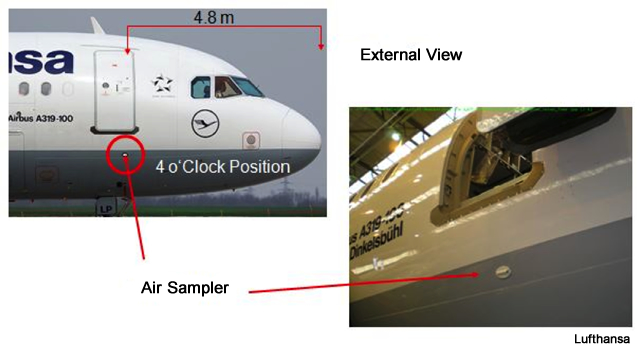
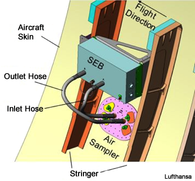
The deployment of a water vapour sensor can happen at the discretion of the airline and does not require routine maintenance. Some units have functioned without maintenance for four years and the primary unit can be swapped out in a few hours. If the sensor malfunctions, it will not affect the operation of the aircraft.
Watch this video from Southwest Airlines about their AMDAR participation, including the deployment of water vapour sensors on their aircraft.
Here is information about installing specific sensors:
Stewart Taylor, U.K. Met Office
Show/Hide Transcript
In addition to the basic AMDAR variables that we've mentioned, the wind and temperature information, there's currently an option to install a humidity sensor on the aircraft. The latest version of this water vapour sensing system, known as the WVSS2 version 3, is the sensor deemed by the AMDAR community as viable, as operational and compatible with the AMDAR program. The installation of this humidity sensor does require some additional work from the airline. All that would be required is a supplemental-type certificate, (STC). This grants the approval for an alteration to the aircraft as a major change in the aircraft type design. There'll also be the purchase of the sensor and the associated hardware and then obviously the installation on the aircraft. Recent studies are showing that the maintenance of the sensor once installed is anything between two and four years so very little maintenance is needed by the airline once the sensor is installed. I won't go into great detail on the WVSS as this is discussed in more detail elsewhere in the module. In addition to humidity, recent developments within the field of turbulence forecasting have seen the addition of what we call a turbulence reporting module on some airlines. The algorithms for this turbulence are based on Eddy dissipation rate, (EDR), and are currently being evaluated in the US. I know within Europe that Air France, who are a Delta-partner airline, are also looking at installing this EDR within Europe. Aviation icing is another variable being investigated by the AMDAR community. Further information on the topic of icing reporting can be found on the WMO AMDAR webpages and further information from the AMDAR people themselves.
Talk to an AMDAR Systems Manager » Test your knowledge
Check what you have learned from your meeting by answering these questions.
Question 1
Which of the following statements correctly describes the requirements for AMDAR instrument implementation on aircraft? Select the best answer.
The correct answer is b.
The AMDAR system is an integration of existing aircraft sensors with an additional software module to carry out computing operations. The system does not replace existing sensors or computing modules on the aircraft.
Question 2
Which type of aircraft is best suited for installation of the AMDAR system? Select the best answer.
The correct answer is d.
Newer large commercial jets are most suitable for AMDAR installation because of the high computational and communication requirements of the system. Older or smaller aircraft may not have the computational power required for data processing but some older aircraft can be retrofitted to set up appropriate computational/communications systems.
Question 3
Match the data type to the communication method most appropriate for its delivery.
See your answers above. In general, data gathered while ascending and cruising is transmitted via VHF air-to-ground networks. If satellite communications or ACARS are not used during flights, larger archives of data can be transmitted once the aircraft has landed via ground-to-ground networks.
Question 4
Which of the following statements correctly describes the installation and maintenance requirements for installing a water vapour sensor? Select the best answer.
The correct answer is d.
The sensor is placed under the forward door on either side. It requires around 50 hrs of work for installation during C or D maintenance checks and does not need regular maintenance. The sensor weighs 4.75 kg, and uses 28 VDC power.
Next Steps
If you decide that youd like to pursue the establishment of the AMDAR program in your country, it is useful to begin by assessing your countrys requirements for upper air data. In general, you can start by reviewing the current implementation of the national composite upper air observing system (radiosondes, radar wind profilers, polar orbiting or geostationary satellites, etc.) and determine whether there are any gaps, or efficiencies to be gained by using AMDAR.
- If you are a member of a meteorological service or an observing system manager, you should find out more from the WMO website or from the WMO Regional Association.
- If you are a forecaster within a NHMS, you should contact your observing systems management team and ask them to find out more about AMDAR (see above).
- If you are a member of an airline, you should contact your national meteorological service or the WMO.
The WMO coordinates the operation of the AMDAR system at the international level through a collaboration between national Members via its Technical Commissions and Regional Association. It facilitates training and technical workshops which support the development of new programs. AMDAR is a component system of the WMO Global Observing System that provides the observational data required for operation of the WMO World Weather Watch Programme and other WMO programs. The WMO also:
- provides and shares global data (including aircraft-based observations) through WMO Members on the WMO Global Telecommunications System. This ensures that the national and international requirements for observational data that support meteorological forecasting applications are met.
- maintains the standards and regulations (e.g. functional requirements for AMDAR onboard software, requirements for data processing, data quality control, format of data for dissemination of data on the GTS, etc) for operation of the AMDAR observing system by its Members.
- facilitates the interaction with other relevant international aviation bodies such as ICAO, IATA and the AEEC.
- coordinates promotional and outreach activities (e.g. such as the development of this COMET lesson).
As part of your evaluation process, it is a good idea to consult with other national meteorological services as increased participation augments the observational coverage for several countries. Collaborations could lead to a possible cost sharing arrangement for developing the infrastructure.
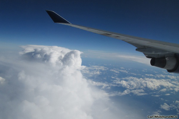
Next, it is important to determine the airlines capabilities and areas of coverage. Some questions to consider are:
- Which types of aircraft does the airline operate and over which routes does each aircraft type tend to fly?
- Of these types, which fly domestic routes and which fly internationally?
- What is the age of the aircraft? The more modern the aircraft, the more likely it will be able to accommodate an AMDAR software application. Note however that it will eventually be necessary to determine exactly which avionics the aircraft has and whether or not it will support an AMDAR software application.
- Of prime importance is whether the airline and aircraft have ACARS (communications) capability, which enables the near-real-time automated reporting functionality required for AMDAR program operation.
- Which airports does each airline and aircraft fleet service routinely?
- Based on the airline flight schedules, how many vertical profiles per day at each airport are likely to be obtained through equipping the different aircraft types?
- Is the airline well established, stable and likely to continue operation well into the future?
The Airlines AMDAR Compatible Systems Survey (available from the linked page) may be a useful resource as you begin your assessment.
As part of the process, you may wish to develop several contacts within the airline. They could serve as a way to begin future discussions about implementing AMDAR and ultimately, may be critical in obtaining management buy-in to the program.
If you determine that your country's or regions upper air observations would be augmented by implementing AMDAR and that airline companies are interested and have the capabilities of adapting their aircraft, then you begin the negotiations. You will need to build a strong case for how and why the airlines will benefit from the AMDAR program. Feel free to use any of the materials in this online lesson as you prepare.
For more information about implementing the AMDAR program in your region, review the WMO Integrated Global Observing System Technical Report No. 2014-02.
Here is some advice for people wanting to take the next steps in implementing AMDAR:
Dr. Olli Marius Turpeinen, Aviation Consultant
Show/Hide Transcript
The important point is that you will have to discuss it with each individual airline. I mentioned to you earlier on that the data is not required as far as aviation is concerned. In other words, you cannot force an airline to provide you with this data. However, I think that it is quite clear that if you discuss the benefits, indirect benefits for airlines, you can perhaps come up with a fairly reasonable conditions for obtaining this data from an airline. But I think that there is no single approach, you really have to play it by ear and to see how certain airlines respond. Unfortunately, some will never ever provide this data and with others you will be more successful. So I think it needs to be approached with patience, negotiations, and convincing.
If you'd like to talk to someone about AMDAR, please fill out this information form on the WMO website.