Introduction
You are a director of a meteorological service on a site visit to a regional office. You are conversing with Akriti Venk, the regional manager, when you hear an urgent knock on the door. Sonia, one of the local forecasters, walks in quickly and says, “Sorry to interrupt, but we have a problem. An air traffic manager called and told me that a transcontinental passenger jet has encountered stronger headwinds than anticipated at 32,000 feet. He is concerned that they will run out of fuel over the ocean and not reach their airport. He needs help now but none of our tools allows me to see the wind speeds at flight altitudes to find more favourable conditions. Can we do anything to help?”
“A colleague in another weather service told me that they have just obtained access to aircraft weather data through a program called AMDAR. The aircraft data provide information about wind speed and other conditions at flight altitudes. I’ll call him right away and see if he can help. May I use your phone, Akriti?”
“Go right ahead.”
You dial your colleague’s number. “Hi, Francisco. We have an urgent problem with an aircraft running low on fuel because of headwinds. Could you take a look at your current AMDAR data and tell us which altitudes or areas might have more favourable winds?”
“Right away," says Francisco. "Where is the plane currently?”
“They are over the Atlantic Ocean about 240 km northeast of Nassau in The Bahamas. Their altitude is 32,000 feet, heading due west en route to Miami,” you reply.
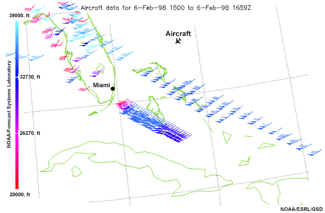
“All right. Let me pull it up. Hmm... OK, here are some flight paths with data indicating that between 18,000 and 20,000 feet the winds are much weaker. I suggest that if they can, the traffic managers should get the plane to a lower altitude. There is also an area of lower wind speeds about 100 km to the south of their current position.” says Francisco.
“Thanks, Francisco!” Turning to Sonia you say: "Sonia, tell the manager that winds are favourable between 18,000 and 20,000 feet and about 100 km south of their current location."
“I’ll contact them right away,” says Sonia, who disappears quickly.
Thirty minutes later Sonia returns. She looks relieved. “I just heard from the traffic manager that the plane is on track for final approach. The new altitude had lower headwind speeds and the aircraft is making better time.” She pauses and then says, “These data could be really useful for us, too. What would it take for our weather service to be able to get access to AMDAR?”
“I don’t know, Sonia, but the information available through AMDAR might have just prevented a serious incident...who really knows what would have happened? Even in the best situation, the flight may have had to detour to a different airport, and not all island airports are equipped for very large planes. And that wouldn't even take into account the cost of getting several hundred passengers from an alternate airport to Miami.”
As Sonia leaves the room, Akriti reflects on the situation. “We were fortunate that you were here today. The data were really useful," she says. "I know that AMDAR stands for Aircraft Meteorological Data Relay and it is a World Meteorological Organization, or WMO, program. Various aircraft collect and record observations including air temperature, wind speed and direction, and vertical profiles of the atmosphere with precise location and timing information and the airlines share these data with meteorological services. But I am not sure how it is set up. How much would the program cost to implement? I am not really sure that our airlines would share the costs of such a program; they would need to know more about what's involved and the benefits. Also, what are the communication requirements for transmitting and receiving the data from the instruments?”
“You are right. We have a lot to learn. The program is a collaboration between meteorological services and commercial airlines. I have heard that participating aircraft currently report over 600,000 daily observations, though there are many areas around the world where AMDAR coverage remains sparse. But given that AMDAR is capable of producing so many observations per day, I suspect the data must have quite a significant impact on the global and national computer models that we use for aviation forecasting—that would be reason enough for airlines to provide their data. I need to look into the benefits and requirements more closely.”
Now that you’ve decided to learn more about AMDAR and how to implement it, you prepare specific questions to ask a meteorologist, an aviation representative, and an AMDAR systems manager. As you start your research, you might also look at this document on Aircraft-based Observations Statistics to learn more about how AMDAR is being used globally: WMO Aircraft-based Observations Data Statistics