Introduction
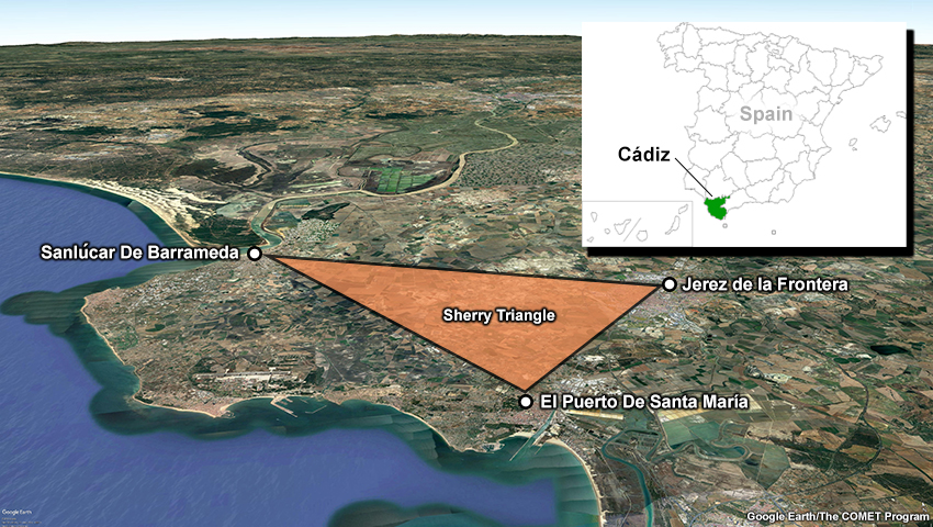
The Sherry Triangle, an area in the province of Cádiz in southwestern Spain that is known for its sherry wine production.
Spain is one of the world’s largest wine producers; grapes are an important commodity of the country’s agriculture industry.
Imagine you are a solar engineer consulting with a farmer about their vineyard in the Sherry Triangle, an area in southwestern Spain known for its sherry wine production. Due to the increased demand for sherry, farmers growing white grapes in the city of Jerez de la Frontera are interested in installing solar electric panels to help reduce electric costs for powering farm operations. You were sent to assess the value of installing solar panels in the area.
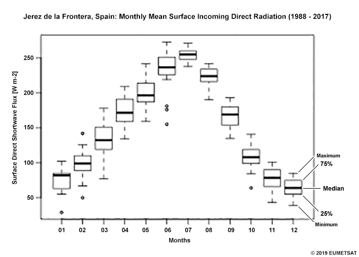
You understand how much land is needed to accommodate a sufficient number of solar panels to power the entire vineyard. However, the quantity of land needed is greater than the amount of land available on this particular farmer’s vineyard. In order to leverage what is available in the smaller plot of land, you must determine whether there is adequate solar radiation to power the solar panels during the grape growing season from June through September. You have analyzed a 30-year climate data record (CDR) from EUMETSAT's Satellite Application Facility on Climate Monitoring (CM SAF) of surface incoming direct radiation for the city.
Review the data plot and answer the questions in the carousel below. Click the arrows on the right and left side of the panel to navigate through the questions.
Question 1 of 3
You know that solar panels are most efficient when the monthly mean surface incoming direct radiation is at least 150 W/m2. What months have at least 50% of their observations recording 150 W/m2? Choose all that apply.
The correct answers are d, e, f, g, h, i.
Please continue to the next question.
Please make a selection.
Question 2 of 3
Would you inform the farmer that the vineyard is a good location to install the solar panels and support the grape growing season? Choose the best answer.
The correct answer is a.
From April through September, the monthly mean observations exceed the 150 W/m2 threshold. Therefore, the climatology record shows that the average surface incoming direct radiation exceeds the farmer’s critical threshold during the grape growing season (June-September). From this analysis, you conclude that installing solar panels in the vineyards around the city of Jerez de la Frontera will be efficient. The high mean values of incoming direct radiation will yield great energy from the solar electric panels and help reduce the cost for farmers managing their vineyards.
Please make a selection.
Question 3 of 3
Can you use the climatology data to reassure the farmer that there will be a particular amount of incoming radiation? Choose the best answer.
The correct answer is b.
The data you used in your solar panel assessment was from a satellite-derived thematic climate data record (TCDR). A TCDR contains information concerning geophysical variables that are specific to diverse fields of study. In this case, the TCDR provided you with three decades of historical observations in which you were able to extract an estimation of the direct solar radiation you could expect in any particular month. Note that this is not a guarantee that you will “harvest” that amount of incoming radiation. You stress that the farmer might need additional power sources because the size of his plot and the variability of solar radiation year to year.
You could also use these data to extract information on what is the best and worst-case scenario for incoming radiation based on what was observed in the past. Such information can help you better plan your solar panel installations by estimating the potential need for additional energy sources during a less sunny year.
Please make a selection.
What other information can we learn from a CDR? Before we answer this question, let’s explore the various CDRs available and how we can obtain one from the CM SAF.