Media elements used in this module are protected by a variety of copyright licenses. Please use the "copyright terms" link associated with each item below for more information.
Description:
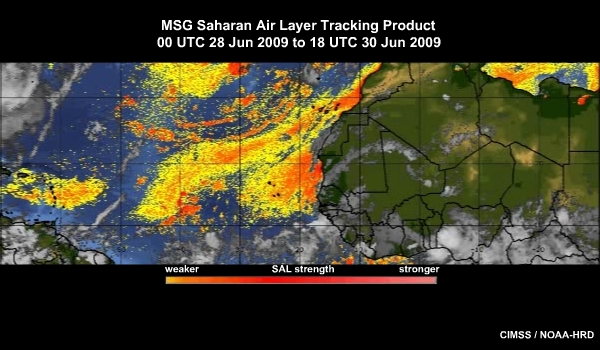
SAL Tracking Product showing the Saharan air layer moving across the Atlantic Ocean from 28 to 30 June 2009
File Name:
090630_met9_sal_anim.mp4
Credits:
CIMSS / NOAA-HRD
Copyright Terms:
COMET Standard Terms of Use
Description:
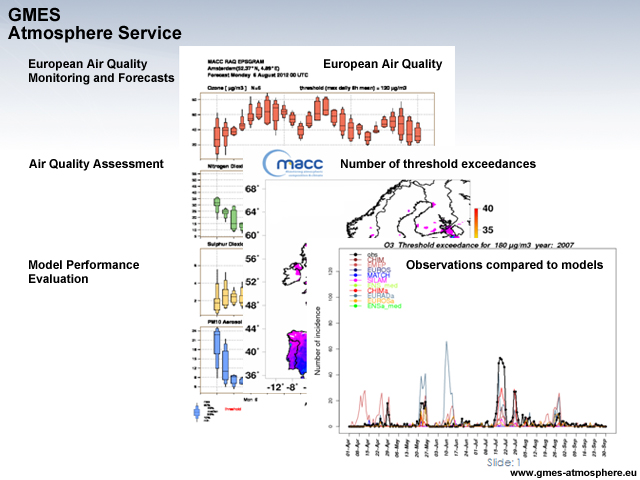
Graphic depicting various air quality components of the European Earth monitoring programme GMES (Global Monitoring for Environment and Security)
File Name:
100_MACC_reg_aq.jpg
Credits:
www.gmes-atmosphere.eu
Copyright Terms:
COMET Standard Terms of Use
Description:
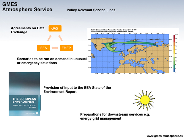
Graphic depicting policy relevant services lines of the European Earth monitoring programme, GMES (Global Monitoring for Environment and Security)
File Name:
101_MACC_Policy.jpg
Credits:
www.gmes-atmosphere.eu
Copyright Terms:
COMET Standard Terms of Use
Description:
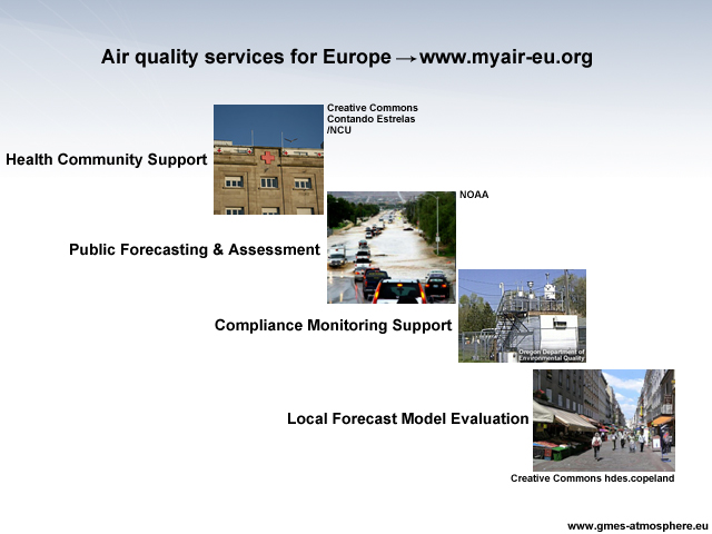
Graphic depicting Myair air quality services for Europe
File Name:
102_pasadoble.jpg
Credits:
© The COMET Program
Copyright Terms:
COMET Standard Terms of Use
Description:
Logo celebrating the 25th year of the Montreal Protocol
File Name:
25_years_Ozone_logo.jpg
Credits:
Ozone Secretariat, UNEP / NCU
Copyright Terms:
COMET Standard Terms of Use
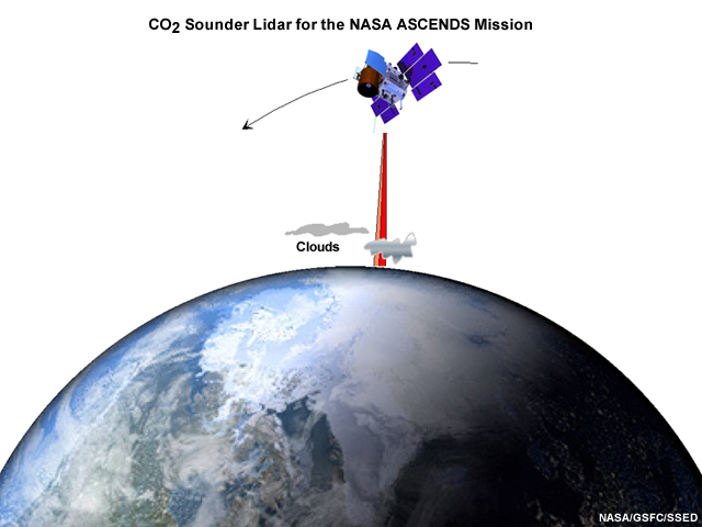
Description:
Space measurement concept for the CO2 sounder lidar for the NASA ASCENDS mission
File Name:
54a_ASCENDS_CO2_Lidar.jpg
Credits:
NASA/GSFC/SSED
Copyright Terms:
COMET Standard Terms of Use
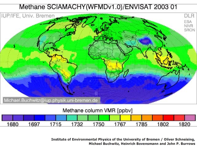
Description:
Methane data from SCIAMACHY on ENVISAT
File Name:
59_scia_ch4_ani_buchwitz.mp4
Credits:
Institute of Environmental Physics of the University of Bremen / Oliver Schneising, Michael Buchwitz, Heinrich Bovensmann and John P. Burrows
Copyright Terms:
COMET Standard Terms of Use
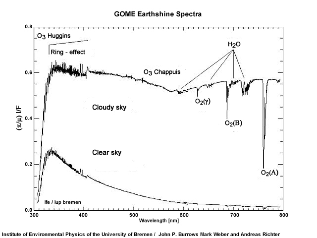
Description:
Spectrum showing the Chappuis bands
File Name:
66_Chappuis_Bremen_Spectrum.jpg
Credits:
Institute of Environmental Physics of the University of Bremen / John P. Burrows Mark Weber and Andreas Richter
Copyright Terms:
COMET Standard Terms of Use
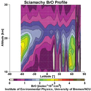
Description:
Sciamachy BRO Data for 06-May-2005
File Name:
69b_SCIAMACHY_Profile_Data_BrO.jpg
Credits:
Institute of Environmental Physics, University of Bremen/NCU
Copyright Terms:
COMET Standard Terms of Use
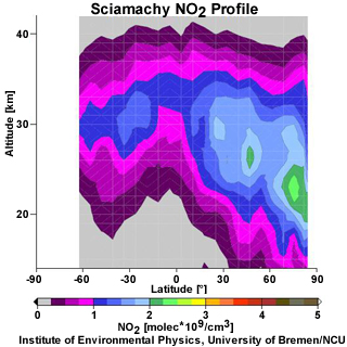
Description:
Sciamachy NO2 Data for 06-May-2005
File Name:
69b_SCIAMACHY_Profile_Data_NO2.jpg
Credits:
Institute of Environmental Physics, University of Bremen/NCU
Copyright Terms:
COMET Standard Terms of Use
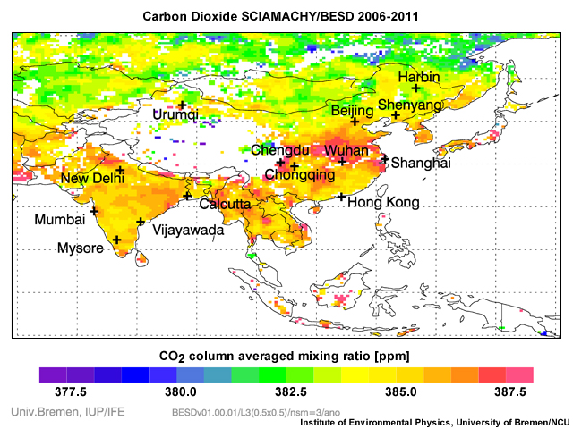
Description:
Sciamachy carbon dioxide data 2006-2011
File Name:
69c_SCIAMACHY_CO2.jpg
Credits:
Institute of Environmental Physics, University of Bremen/NCU
Copyright Terms:
COMET Standard Terms of Use

Description:
Latitudinal PAN distribution, averaged zonally and over 10 days between 4 October and 1 December, 2003
File Name:
69d_MIPAS_PAN.jpg
Credits:
N. Glatthor et al. (2007)
Copyright Terms:
COMET Standard Terms of Use
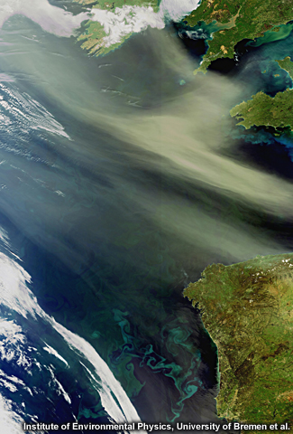
Description:
Envisat captures dust and sand from the Algerian Sahara Desert, located in northern Africa, blowing west across the Atlantic Ocean. Plankton blooms are visible as blue and green swirls.
File Name:
69e_MERIS_Dust_and_Phytoplankton.jpg
Credits:
Institute of Environmental Physics, University of Bremen et al.
Copyright Terms:
COMET Standard Terms of Use
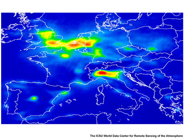
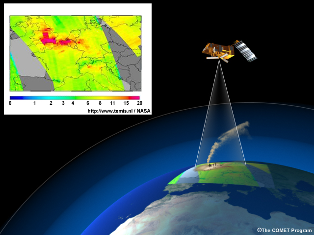
Description:
Total amount of nitrogen dioxide (NO2) in the atmosphere above Europe derived from one year of data from the GOME-2 instrument on Metop-A (March 2007 - February 2008).
File Name:
70a_GOME-2_Tropospheric_NO2_2007.jpg
Credits:
The ICSU World Data Center for Remote Sensing of the Atmosphere
Copyright Terms:
COMET Standard Terms of Use
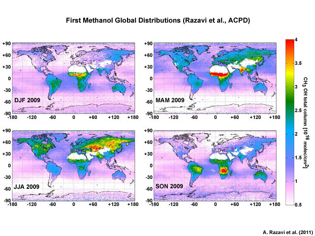
Description:
Seasonal distributions of methanol total columns for the year 2009. The white areas correspond to a filter for sandy scenes where emissivity is uncertain
File Name:
70b_IASI_Methanol.jpg
Credits:
A. Razavi et al. (2011)
Copyright Terms:
COMET Standard Terms of Use
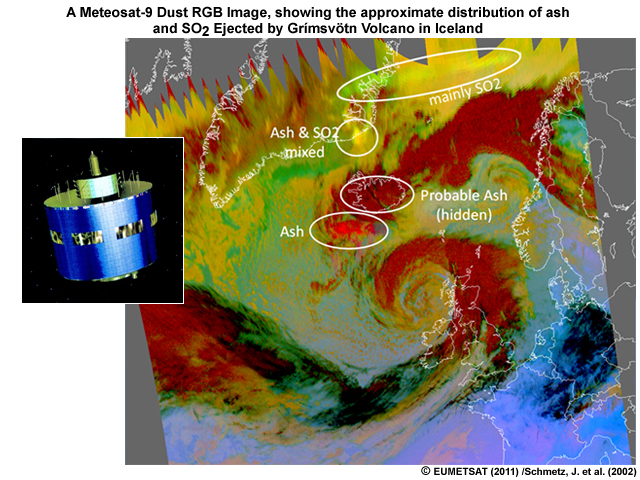
Description:
MSG space craft with a A Meteosat-9 Dust RGB image, showing the approximate distribution of ash and SO2 ejected by Grímsvötn volcano in Iceland
File Name:
71_MSG.jpg
Credits:
© EUMETSAT (2011) /Schmetz, J. et al. (2002)
Copyright Terms:
COMET Standard Terms of Use
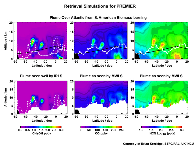
Description:
Retrieval simulations for PREMIER
File Name:
72c_PREMIER_Retrieval_Simulations.jpg
Credits:
Courtesy of Brian Kerridge, STFC/RAL, UK/ NCU
Copyright Terms:
COMET Standard Terms of Use

Description:
Sentinel-4 east-west scan for continuous monitoring above Europe and northern Africa
File Name:
74a_Sentinel_4.jpg
Credits:
© Astrium 2012
Copyright Terms:
COMET Standard Terms of Use
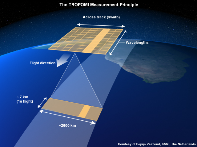
Description:
Conceptual graphic of the TROPOMI measurement principle
File Name:
75b_tropomi.jpg
Credits:
Courtesy of Pepijn Veefkind, KNMI, The Netherlands
Copyright Terms:
COMET Standard Terms of Use
Description:
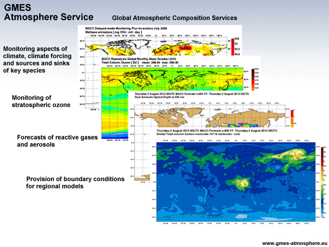
Graphic depicting various atmospheric composition services of the European Earth monitoring programme GMES (Global Monitoring for Environment and Security)
File Name:
99_MACC_global_atm_comp.jpg
Credits:
www.gmes-atmosphere.eu
Copyright Terms:
COMET Standard Terms of Use
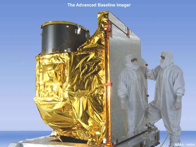
Description:
The Advanced Baseline Imager that will be on the GOES-R satellite
File Name:
ABI_complete.jpg
Credits:
NOAA / NASA
Copyright Terms:
COMET Standard Terms of Use
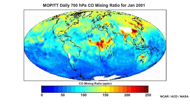
Description:
Satellite data of CO concentrations (March 2000- May 2001)
File Name:
acd_mopitt_2000.mp4
Credits:
NCAR / ACD / NASA
Copyright Terms:
COMET Standard Terms of Use
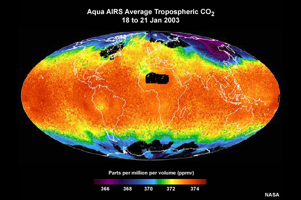
Description:
Tropospheric average carbon dioxide concentrations as retrieved from EOS Aqua AIRS sounder data from 18 to 21 January, 2003
File Name:
airs_co2.jpg
Credits:
NASA
Copyright Terms:
COMET Standard Terms of Use
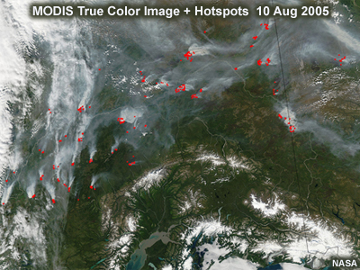
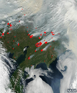
Description:
Fires, smoke, and burn scars in Alaska and Yukon Territory, true color image, Aqua MODIS, 10 August 2005
File Name:
Alaska_true_color_hotspots.jpg
Credits:
NASA
Copyright Terms:
COMET Standard Terms of Use
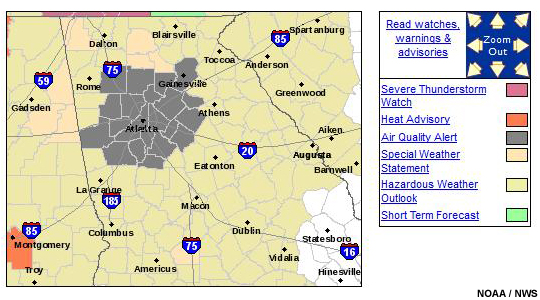
Description:
A graphical forecast for part of Georgia showing areas under an air quality alert
File Name:
aq_alert.jpg
Credits:
NOAA / NWS
Copyright Terms:
COMET Standard Terms of Use
Description:
Graphical air quality forecasts for dust, smoke, and ozone for the entire U.S.
File Name:
aq_fcsts_0001.htm
Credits:
NOAA / NWS
Copyright Terms:
COMET Standard Terms of Use
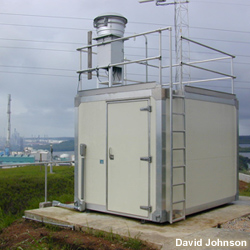
Description:
Air quality monitoring station
File Name:
aq_station.jpg
Credits:
David Johnson
Copyright Terms:
COMET Standard Terms of Use
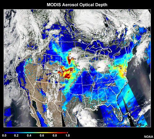
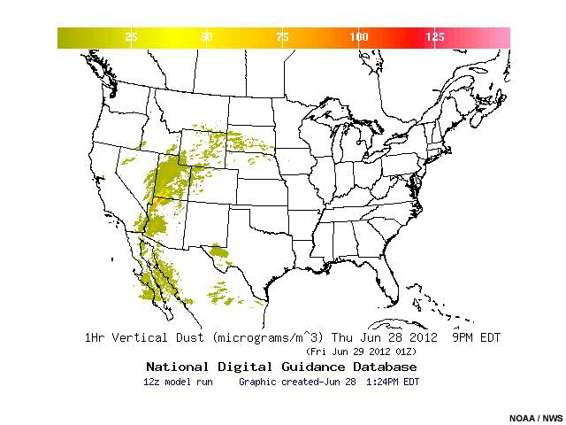
Description:
MODIS Aerosol Optical Depth
File Name:
Aqua_MOD_RGB_AOD_CONUS_29jun2012.jpg
Credits:
NOAA
Copyright Terms:
COMET Standard Terms of Use
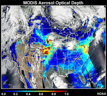
Description:
MODIS Aerosol Optical Depth
File Name:
Aqua_MOD_RGB_AOD_CONUS_29jun2012_sm.jpg
Credits:
NOAA
Copyright Terms:
COMET Standard Terms of Use
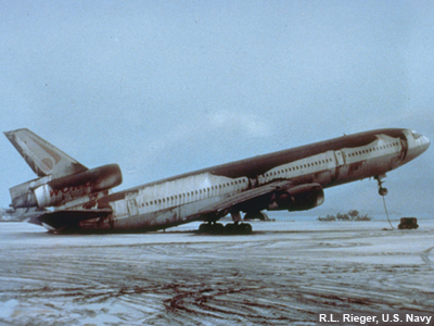
Description:
Ashfall on a commercial airplane in the Phillipines after the eruption of Mt. Pinatubo. So much ash is on the airplane that the tail has tipped to ground.
File Name:
Ashfall_Airplane.jpg
Credits:
R.L. Rieger, U.S. Navy
Copyright Terms:
COMET Standard Terms of Use
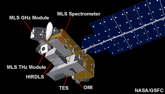
Description:
Artist's drawing of Aura's four instruments, HIRDLS, MLS, OMI, and TES, which contain advanced technologies that have been developed for use on environmental satellites.
File Name:
aura_spacecraft_sm.jpg
Credits:
NASA/GSFC
Copyright Terms:
COMET Standard Terms of Use

Description:
Conceptual diagram of Rayleigh and Mie scattering
File Name:
backscatter.jpg
Credits:
© The COMET Program
Copyright Terms:
COMET Standard Terms of Use
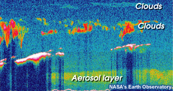
Description:
Example of data from CALIPSO lidar showing clouds and an aerosol layer in a curtain-like image
File Name:
CALIPSO_curtain.jpg
Credits:
NASA’s Earth Observatory
Copyright Terms:
COMET Standard Terms of Use
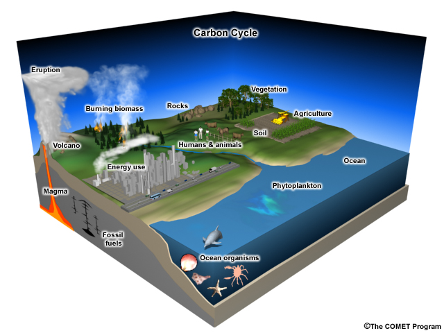
Description:
Pieces of the carbon cycle
File Name:
carboncycle.jpg
Credits:
© The COMET Program
Copyright Terms:
COMET Standard Terms of Use
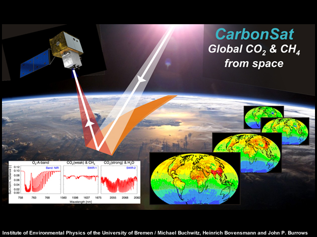
Description:
CarbonSat--the Carbon Monitoring Satellite
File Name:
carbonsat_w.jpg
Credits:
Institute of Environmental Physics of the University of Bremen / Michael Buchwitz, Heinrich Bovensmann and John P. Burrows
Copyright Terms:
COMET Standard Terms of Use
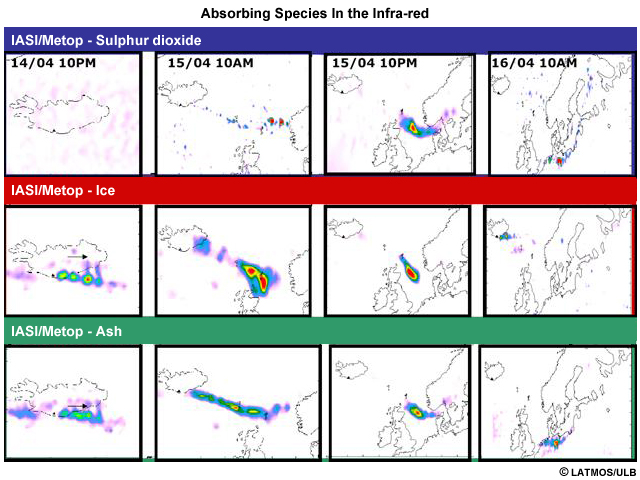
Description:
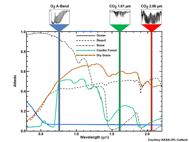
Absorbing species in the infra-red
File Name:
clerbaux_ash_ice_so2.jpg
Credits:
© LATMOS/ULB
Copyright Terms:
COMET Standard Terms of Use
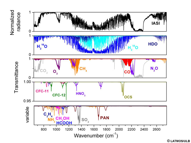
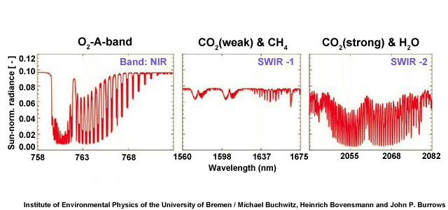
Description:
Top panel: radiance atmospheric spectrum (in normalized units) recorded by IASI/MetOp. Middle panels: radiative transfer transmittance simulations to identify the main absorbing gases (middle panels) and the weaker absorbers (lower panel, with a variable scale).
File Name:
clerbaux_IASI_Spectrum.jpg
Credits:
© LATMOS/ULB
Copyright Terms:
COMET Standard Terms of Use
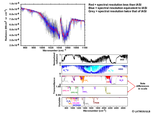
Description:
Spectral resolution and sampling.
File Name:
clerbaux_spec_res.jpg
Credits:
© LATMOS/ULB
Copyright Terms:
COMET Standard Terms of Use
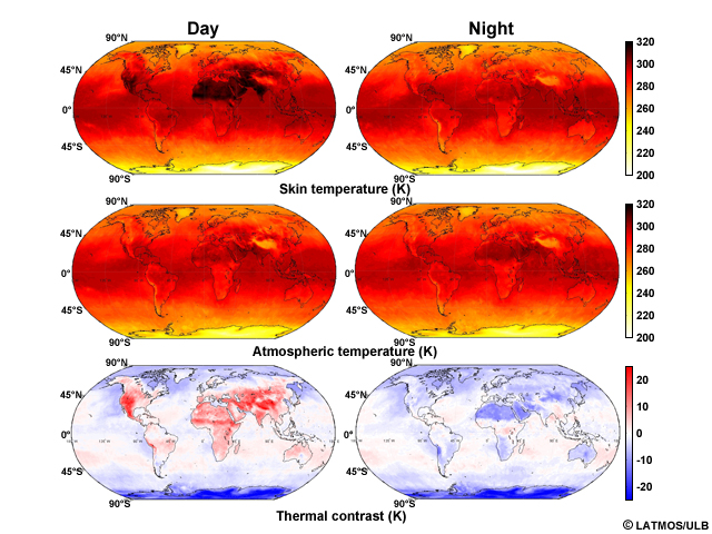
Description:
Example of thermal contrast data. Left side--daytime satellite data. Right side--nighttime satellite data. Top row is surface temperature. The middle plots are temperature above the surface--1st atmospheric layer. The two lower plots are the difference between the surface temperature and atmospheric temperature.
File Name:
clerbaux_thermal_contrast.jpg
Credits:
© LATMOS/ULB
Copyright Terms:
COMET Standard Terms of Use

Description:
Trace gas distributions for some atmospheric products from the IASI mission
File Name:
Clerbaux_Various_TIR_Species.jpg
Credits:
© LATMOS/ULB
Copyright Terms:
COMET Standard Terms of Use
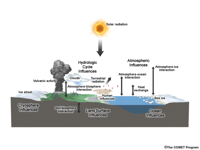
Description:
Conceptual graphic showing many of the influences on climate
File Name:
climate_influences.jpg
Credits:
© The COMET Program
Copyright Terms:
COMET Standard Terms of Use
Description:
Graph showing the trend of mid-tropospheric carbon dioxide from 2003 to 2010 as taken by the AIRS instrument
File Name:
co2_from_airs.mp4
Credits:
NOAA
Copyright Terms:
COMET Standard Terms of Use
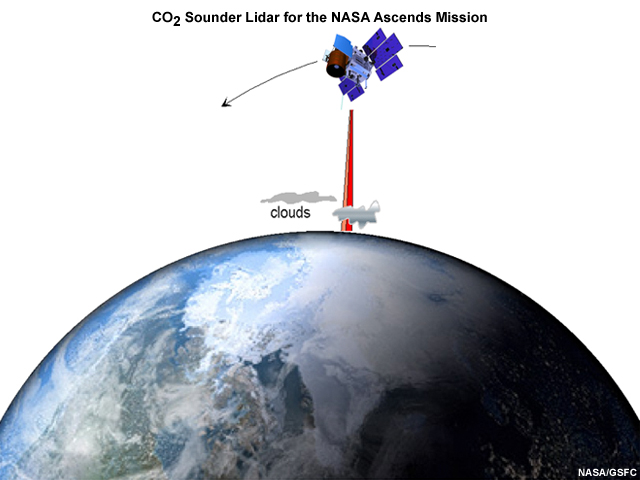
Description:
The NASA Goddard CO2 Sounder lidar is a candidate for NASA's ASCENDS Earth Science Mission, which will use a lidar to measure the mixing ratio of atmospheric CO2 from orbit. The ASCENDS mission is scheduled to launch in 2019.
File Name:
co2sounderASCENDS.jpg
Credits:
NASA/GSFC
Copyright Terms:
COMET Standard Terms of Use

Description:
Photo of a coal-fired power plant.
File Name:
coalplant.jpg
Credits:
USGS
Copyright Terms:
COMET Standard Terms of Use
Description:
Diagram explaining what XCO2 is
File Name:
crisp_landsurface.jpg
Credits:
Courtesy NASA/JPL-Caltech
Copyright Terms:
COMET Standard Terms of Use
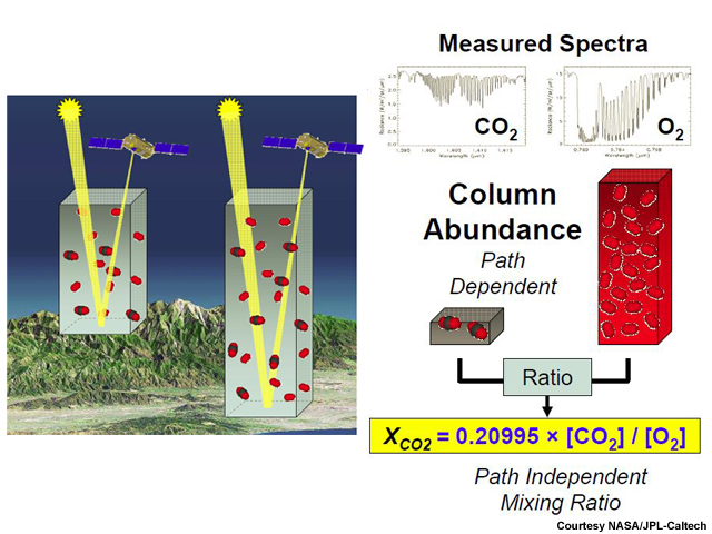
Description:
Diagram explaining what XCO2 is
File Name:
crisp_whatisXCO2.jpg
Credits:
Courtesy NASA/JPL-Caltech
Copyright Terms:
COMET Standard Terms of Use
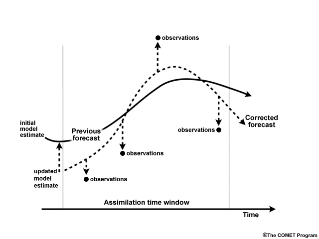
Description:
Graphic depicting data assimilation methodology
File Name:
data_assim.jpg
Credits:
© The COMET Program
Copyright Terms:
COMET Standard Terms of Use
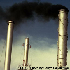
Description:
Smoke from an oil refinery
File Name:
DI00419.jpg
Credits:
© UCAR, Photo by Carlye Calvin / NCU
Copyright Terms:
COMET Standard Terms of Use
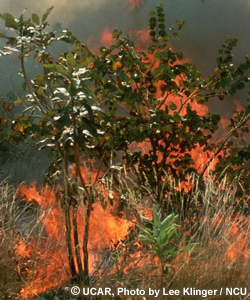
Description:
Grassland and bushes on fire
File Name:
DI00779.jpg
Credits:
© UCAR, Photo by Lee Klinger / NCU
Copyright Terms:
COMET Standard Terms of Use
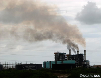
Description:
Industrial power plant
File Name:
DI01197.jpg
Credits:
© UCAR / NCU
Copyright Terms:
COMET Standard Terms of Use
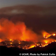
Description:
Wildfire
File Name:
DI02241.jpg
Credits:
© UCAR, Photo by Patrick Cullis
Copyright Terms:
COMET Standard Terms of Use
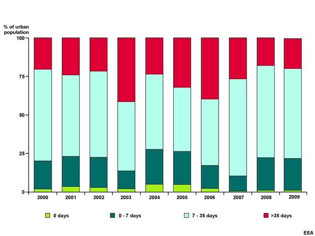
Description:
Percentage of urban populations in areas with PM10 concentration exceeding daily limit value
File Name:
eea_pm10.jpg
Credits:
EEA
Copyright Terms:
COMET Standard Terms of Use
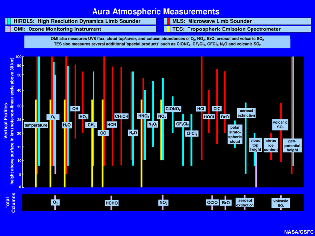
Description:
Graphic that summarizes the atmospheric parameters measured by HIRDLS, MLS, OMI, and TES. The altitude range where these parameters are measured are shown as the vertical scale. In several cases the measurements overlap which provides independent perspectives and cross calibration of the measurements.
File Name:
eos_aura_chemchart.jpg
Credits:
NASA/GSFC
Copyright Terms:
COMET Standard Terms of Use
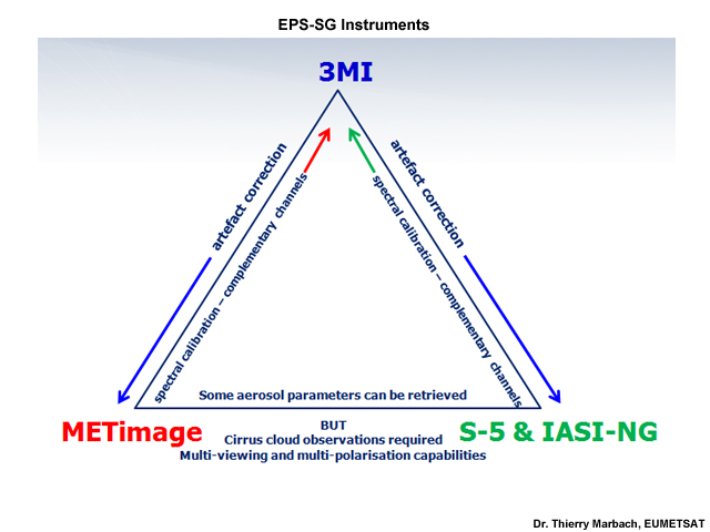
Description:
The EPS Second Generation (EPS-SG) Instruments
File Name:
EPS_SG_Instruments.jpg
Credits:
Dr. Thierry Marbach, EUMETSAT
Copyright Terms:
COMET Standard Terms of Use
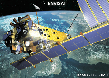
Description:
ESA's ten-instrument Envisat environmental satellite
File Name:
ESA_Envisat.jpg
Credits:
EADS Astrium / NCU
Copyright Terms:
COMET Standard Terms of Use
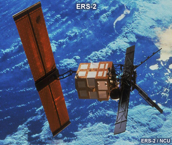
Description:
ERS-2 satellite used to study Earth's land, oceans, atmosphere and polar ice and monitor natural disasters such as earthquakes and floods.
File Name:
ESA_ERS2.jpg
Credits:
ERS-2 / NCU
Copyright Terms:
COMET Standard Terms of Use
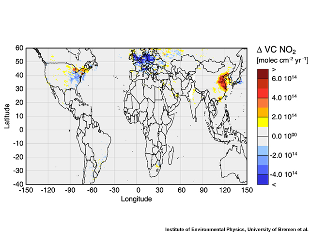
Description:
Average annual changes in tropospheric nitrogen dioxide, as observed by GOME from 1996 to 2002.
File Name:
esa_gome_no2.jpg
Credits:
Institute of Environmental Physics, University of Bremen et al.
Copyright Terms:
COMET Standard Terms of Use
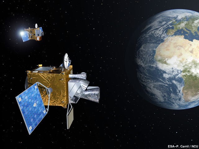
Description:
Meteosat Third Generation (MTG) Imaging and Sounding satellites.
File Name:
esa_mtg.jpg
Credits:
ESA–P. Carril / NCU
Copyright Terms:
COMET Standard Terms of Use
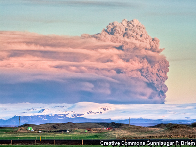
Description:
Dark-grey ash plume rises high above Iceland in this early morning photo of Eyjafjalljokull' s eruption.
File Name:
eyjafjallajokull01.jpg
Credits:
Creative Commons Gunnlaugur P. Briem
Copyright Terms:
Creative Commons Attribution-ShareAlike 2.0
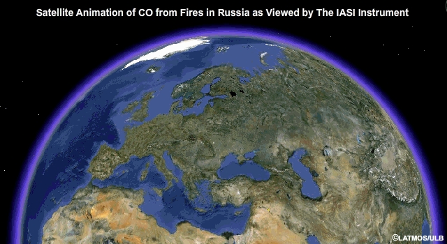
Description:
Satellite animation of carbon monoxide emitted from fires in Russia as viewed by the IASI instrument
File Name:
feux_russie_iasi_juin2012.mp4
Credits:
© LATMOS/ULB
Copyright Terms:
COMET Standard Terms of Use
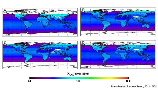
Description:
Distribution of the XCO2 retrieval errors for single soundings in glint mode for January (A), April (B), July (C) and October (D)
File Name:
fig16_mdpi.jpg
Credits:
Boesch et al, Remote Sens., 2011 / NCU
Copyright Terms:
COMET Standard Terms of Use
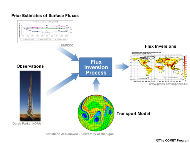
Description:
Diagram showing the elements that go into the flux inversion process (prior estimates of surface fluxes, observations, and transport model)
File Name:
flux_inversion.jpg
Credits:
© The COMET Program
Copyright Terms:
COMET Standard Terms of Use
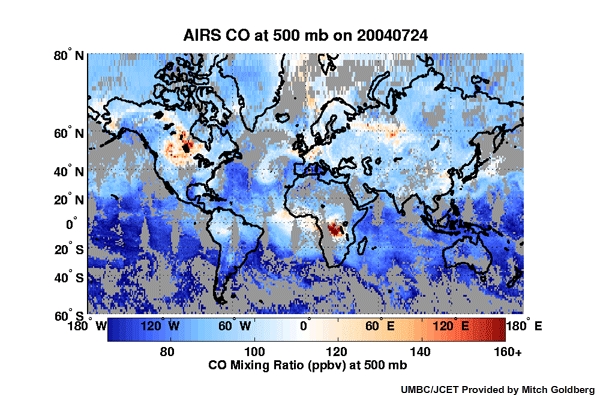
Description:
Animation showing global carbon monoxide measurements at 500 mb from the AIRS instrument from 3 to 24 July 2004
File Name:
fm_July04COfromAIRS-600x419.mp4
Credits:
UMBC/JCET Provided by Mitch Goldberg
Copyright Terms:
COMET Standard Terms of Use
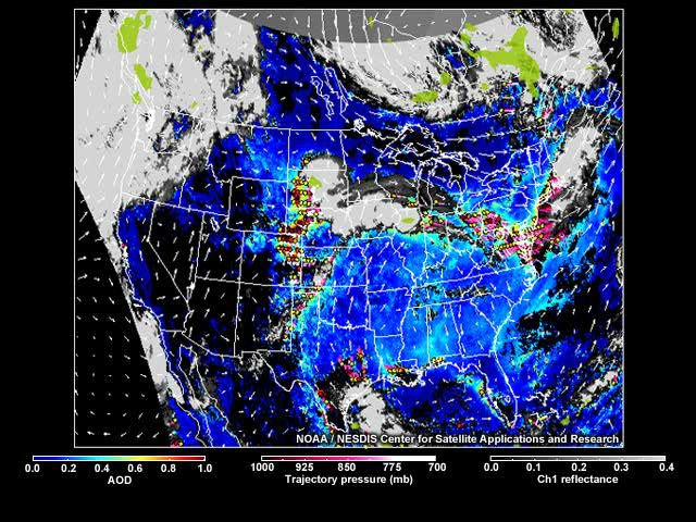
Description:
A 48-hour forecast of aerosol optical depth and trajectories based on blending satellite and ground-based measurements, meteorological observations, and computer modelling
File Name:
gasp_geast_traj_fcst_20120629_ani.mp4
Credits:
NOAA / NESDIS Center for Satellite Applications and Research
Copyright Terms:
COMET Standard Terms of Use

Description:
Geostationary Lightning Mapper coverage overlaid on the globe
File Name:
glm_coverage.jpg
Credits:
NASA / The COMET Program
Copyright Terms:
COMET Standard Terms of Use
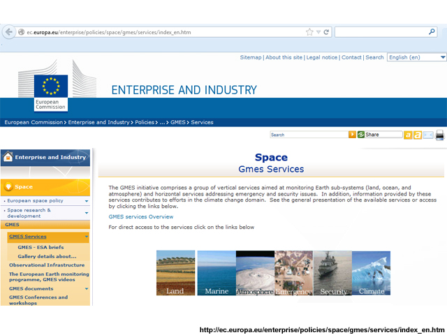
Description:
Screen grab of the GMES Services website at http://ec.europa.eu/enterprise/policies/space/gmes/services/index_en.htm
File Name:
gmes_website.jpg
Credits:
http://ec.europa.eu/enterprise/policies/space/gmes/services/index_en.htm
Copyright Terms:
COMET Standard Terms of Use
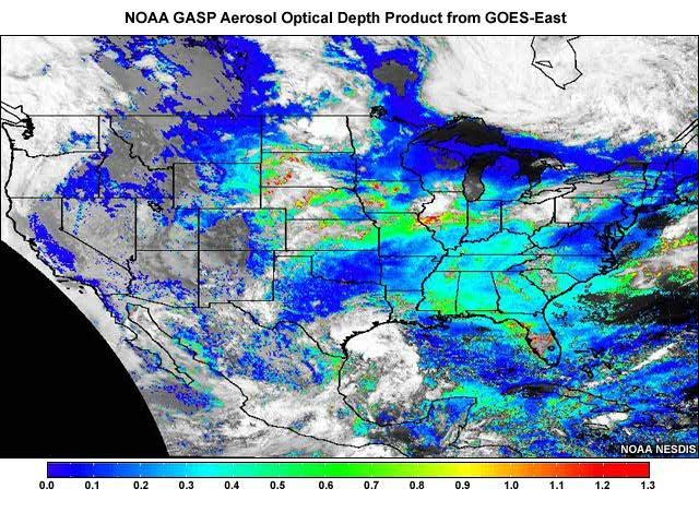
Description:
NOAA GASP aerosol optical depth product from GOES-East
File Name:
goes_aod_ani.mp4
Credits:
NOAA NESDIS
Copyright Terms:
COMET Standard Terms of Use
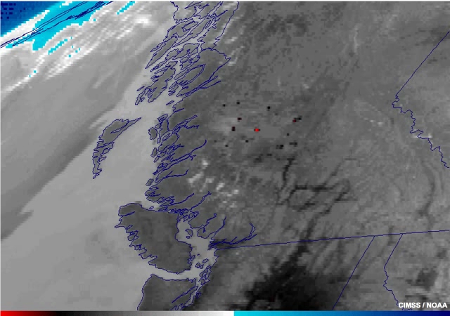
Description:
GOES-15 animation of wildfires and associated hot spots in western Canada (14 Aug 2010)
File Name:
goes_fires_2010.mp4
Credits:
CIMSS / NOAA
Copyright Terms:
COMET Standard Terms of Use
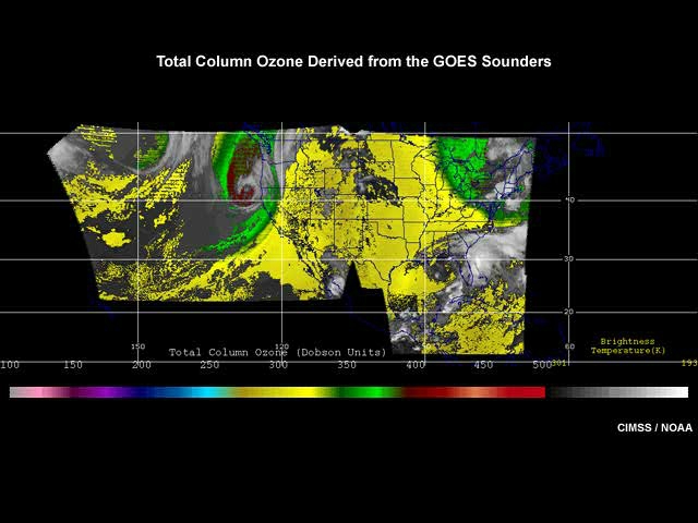
Description:
Animation of total column ozone derived from the GOES sounders
File Name:
goes_ozone.mp4
Credits:
CIMSS / NOAA
Copyright Terms:
COMET Standard Terms of Use

Description:
Artist's drawing of the GOES-R satellite
File Name:
goesr_day_earth.jpg
Credits:
NOAA / NASA
Copyright Terms:
COMET Standard Terms of Use
Description:
Artist's drawing of the GOES-R satellite
File Name:
goesr_day_earth_sm.jpg
Credits:
NOAA / NASA
Copyright Terms:
COMET Standard Terms of Use
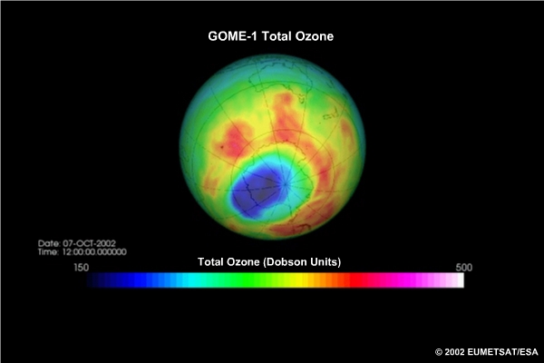
Description:
Animation showing total ozone in Dobson units as measured by the GOME-1 instrument from 18 Sep to 11 Oct 2002
File Name:
gomeozone_ani.mp4
Credits:
©2002 EUMETSAT/ESA
Copyright Terms:
COMET Standard Terms of Use
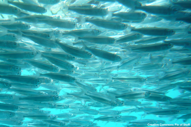
Description:
Image of a shoal of fish near the Great Barrier Reef, off the coast of Australia.
File Name:
Great_Barrier_Reef_Shoal.jpg
Credits:
Creative Commons Pix of Stuff
Copyright Terms:
Creative Commons Attribution 2.0 Generic

Description:
Melting ice sheet, Greenland
File Name:
greenland2.jpg
Credits:
Ian Joughin, PSC/APL/UW
Copyright Terms:
COMET Standard Terms of Use
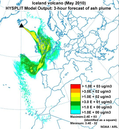
Description:
NOAA Air Resources Laboratory HYSPLIT model 3-hour forecast of the ash plume path from the eruption of Iceland's Eyjafjallajökull volcano in early May 2010
File Name:
hysplit_volc.jpg
Credits:
NOAA / ARL
Copyright Terms:
COMET Standard Terms of Use

Description:
NOAA Air Resources Laboratory HYSPLIT model 3-hour forecast of the ash plume path from the eruption of Iceland's Eyjafjallajökull volcano in early May 2010
File Name:
hysplit_volc_sm.jpg
Credits:
NOAA / ARL
Copyright Terms:
COMET Standard Terms of Use
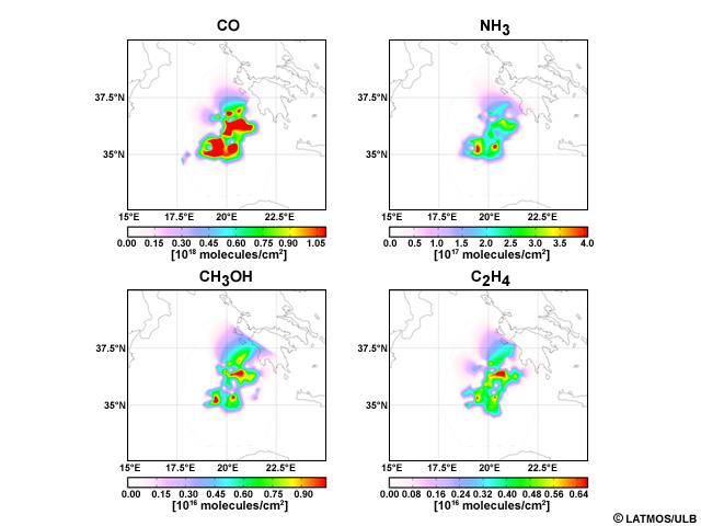
Description:
IASI image from Greek fires
File Name:
IASI_Greek_Fires_Coheur_Latmos_ULB.jpg
Credits:
© LATMOS/ULB
Copyright Terms:
COMET Standard Terms of Use
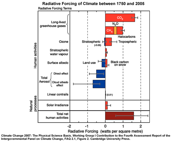
Description:
IPCC Fourth Assessment Report graphic summarizing the principal components of the radiative forcing of climate change
File Name:
ipcc_faq_2_1_fig_2_l.jpg
Credits:
Climate Change 2007: The Physical Science Basis. Working Group I Contribution to the Fourth Assessment Report of the Intergovernmental Panel on Climate Change, FAQ 2.1, Figure 2. Cambridge University Press.
Copyright Terms:
COMET Standard Terms of Use
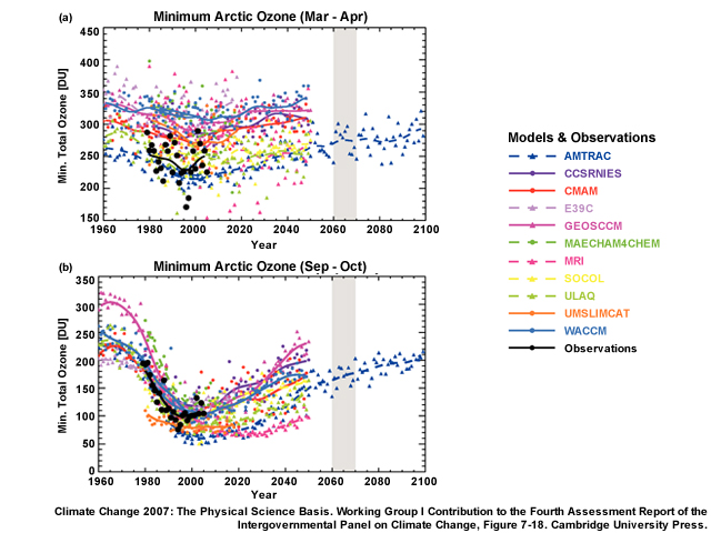
Description:
IPCC Fourth Assessment Report graphics showing minimum Arctic and Antarctic total column ozone measurements and projections from 1960-2100
File Name:
ipcc_fig7_18.jpg
Credits:
Climate Change 2007: The Physical Science Basis. Working Group I Contribution to the Fourth Assessment Report of the Intergovernmental Panel on Climate Change, Figure 7-18. Cambridge University Press.
Copyright Terms:
COMET Standard Terms of Use
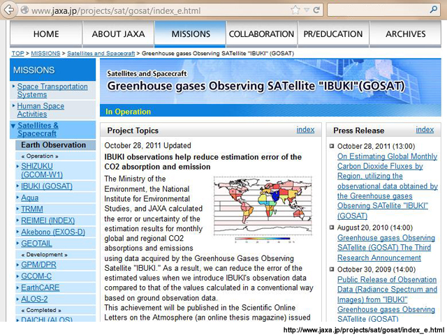
Description:
The Greenhouse Gases Observing Satellite "IBUKI" (GOSAT) is the world's first satellite to observe global greenhouse gases from space.
File Name:
jaxa_ibuki.jpg
Credits:
http://www.jaxa.jp/projects/sat/gosat/index_e.html
Copyright Terms:
COMET Standard Terms of Use
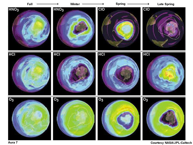
Description:
Seasonal variations in the chemistry of the ozone hole revealed by Aura MLS
File Name:
jpl_aura.jpg
Credits:
Courtesy NASA/JPL-Caltech
Copyright Terms:
COMET Standard Terms of Use
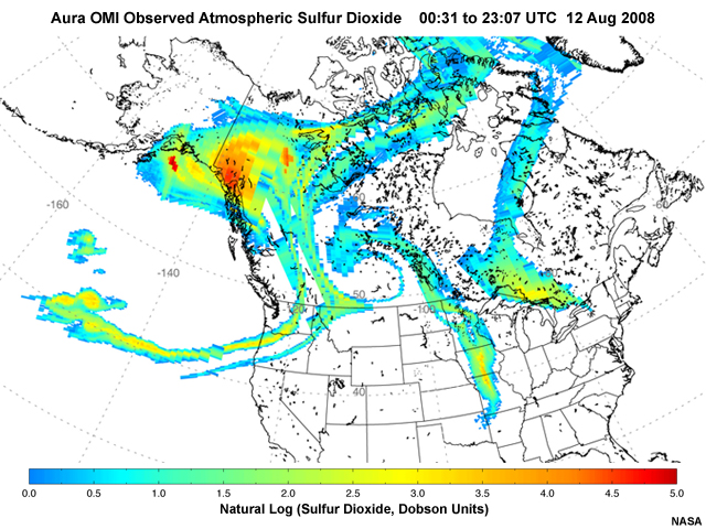
Description:
A large SO2 plume from Kasatochi volcano in the Aleutians masking most of Canada and parts of the United States as viewed from the NASA Ozone Monitoring Instrument
File Name:
Kasatochi_Aura_SO2_Plume.jpg
Credits:
NASA
Copyright Terms:
COMET Standard Terms of Use
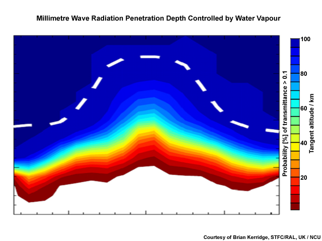
Description:
Atmospheric limb transparency in MM window
File Name:
kerridge_mmw_limb_atm_pen.jpg
Credits:
Courtesy of Brian Kerridge, STFC/RAL, UK / NCU
Copyright Terms:
COMET Standard Terms of Use
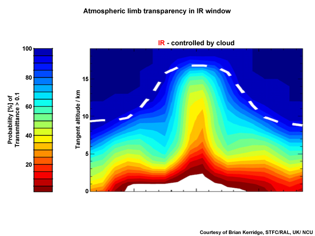
Description:
Atmospheric limb transparency in IR window
File Name:
kerridge_tir_limb_atm_pen.jpg
Credits:
Courtesy of Brian Kerridge, STFC/RAL, UK/ NCU
Copyright Terms:
COMET Standard Terms of Use
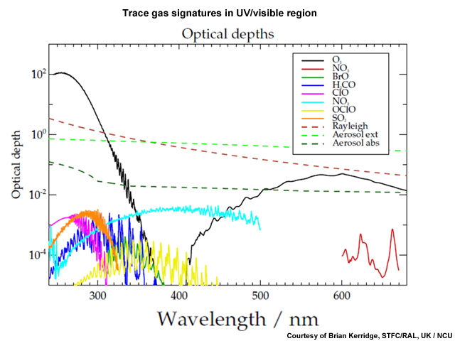
Description:
Trace gas signatures in UV/visible region
File Name:
kerridge_UV_Vis_Species.jpg
Credits:
Courtesy of Brian Kerridge, STFC/RAL, UK / NCU
Copyright Terms:
COMET Standard Terms of Use
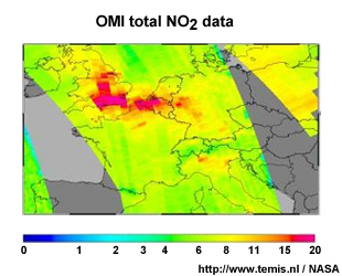
Description:
OMI total NO2 data
File Name:
knmi_omi_no2.jpg
Credits:
http://www.temis.nl / NASA
Copyright Terms:
COMET Standard Terms of Use
Description:
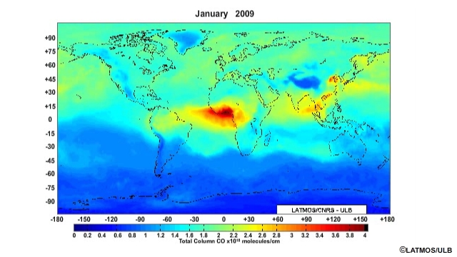
Satellite animation of global total column CO viewed by the IASI instrument
File Name:
latmos_iasi_co_2009.mp4
Credits:
© LATMOS/ULB
Copyright Terms:
COMET Standard Terms of Use
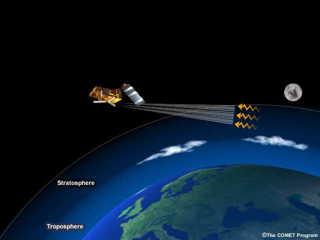
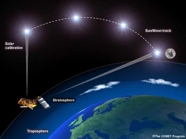
Description:
Illustration of the concept of limb viewing/measurements
File Name:
limb.jpg
Credits:
© The COMET Program
Copyright Terms:
COMET Standard Terms of Use
Description:
Illustration of the concept of limb viewing/measurements
File Name:
limb_2.jpg
Credits:
© The COMET Program
Copyright Terms:
COMET Standard Terms of Use
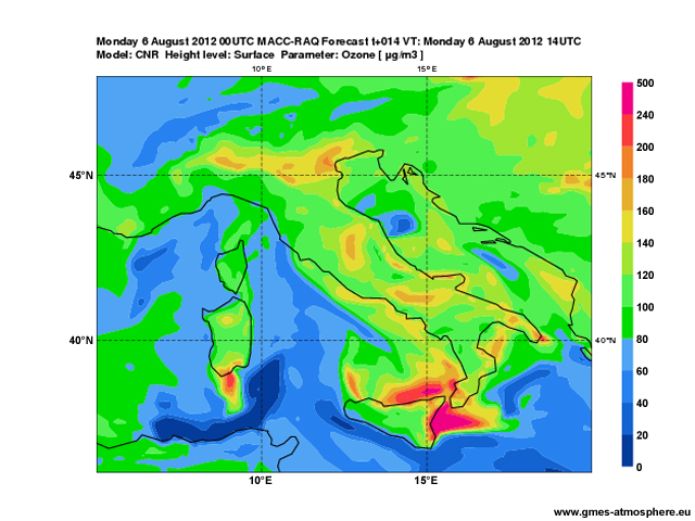
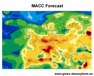
Description:
A MACC ozone forecast graphic centered on Italy
File Name:
macc_ozone.jpg
Credits:
www.gmes-atmosphere.eu
Copyright Terms:
COMET Standard Terms of Use
Description:
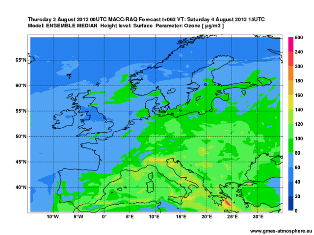
A MACC regional ozone forecast graphic
File Name:
macc_regfcst_o3_2012080200_SFC_063.jpg
Credits:
www.gmes-atmosphere.eu
Copyright Terms:
COMET Standard Terms of Use
Description:
MACC forecast for surface NOx
File Name:
macc_sfc_nox.jpg
Credits:
www.gmes-atmosphere.eu
Copyright Terms:
COMET Standard Terms of Use
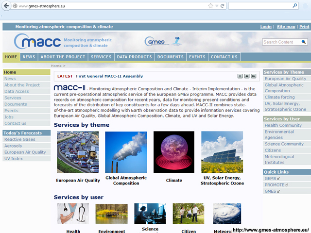
Description:
Screen grab of the MACC Project website at http://www.gmes-atmosphere.eu/
File Name:
macc_website.jpg
Credits:
http://www.gmes-atmosphere.eu/
Copyright Terms:
COMET Standard Terms of Use
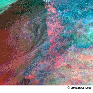
Description:
Wildfires in northwest Spain, August 2006, as viewed by Meteosat-8
File Name:
meteosat_fires_2006.mp4
Credits:
© EUMETSAT (2006)
Copyright Terms:
COMET Standard Terms of Use
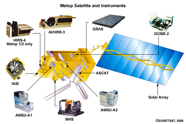
Description:
Illustration of the Metop polar-orbiting satellite and instruments.
File Name:
metoppayload.jpg
Credits:
© EUMETSAT, 2006
Copyright Terms:
COMET Standard Terms of Use
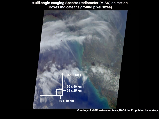
Description:
Multi-angle Imaging Spectro-Radiometer (MISR) animation with boxes indicating the ground pixel sizes
File Name:
misr_florida_short.mp4
Credits:
Courtesy of MISR instrument team, NASA Jet Propulsion Laboratory
Copyright Terms:
COMET Standard Terms of Use

Description:
Artist's conception of the satellite instrument MISR, which uses nine cameras pointed at fixed angles--one viewing the nadir (vertically downward) direction and four each viewing the forward and aftward directions along the spacecraft ground track
File Name:
misr_obs_concept.jpg
Credits:
NASA/JPL
Copyright Terms:
COMET Standard Terms of Use
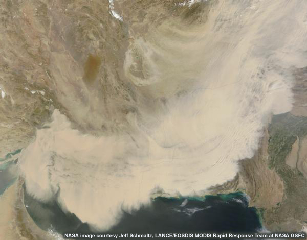
Description:
Terra MODIS image of dust storm over southwest Asia and the Middle East (March 2012)
File Name:
modis_dust_2012.jpg
Credits:
NASA image courtesy Jeff Schmaltz, LANCE/EOSDIS MODIS Rapid Response Team at NASA GSFC
Copyright Terms:
COMET Standard Terms of Use
Description:
Fires and smoke in eastern Siberia as seen with Aqua/MODIS
File Name:
modis_fires.jpg
Credits:
NASA
Copyright Terms:
COMET Standard Terms of Use
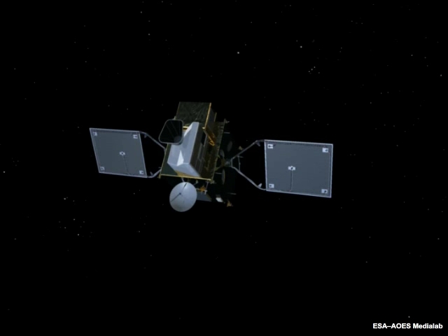
Description:
The Sentinel-4 payload will be carried by a Meteosat Third Generation satellite in geostationary orbit.
File Name:
mtg_anim.mp4
Credits:
ESA–AOES Medialab / NCU
Copyright Terms:
COMET Standard Terms of Use
Description:
MTG-Sounding platform
File Name:
mtg_sndr.jpg
Credits:
ESA–AOES Medialab / NCU
Copyright Terms:
COMET Standard Terms of Use
Description:
Illustration of the concept of nadir viewing/measurements
File Name:
nadir.jpg
Credits:
© The COMET Program
Copyright Terms:
COMET Standard Terms of Use
Description:
Illustration of the concept of nadir viewing/measurements
File Name:
nadir_2.jpg
Credits:
© The COMET Program
Copyright Terms:
COMET Standard Terms of Use
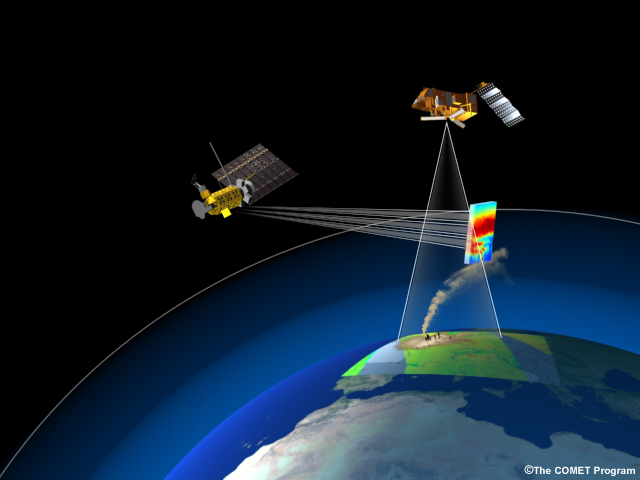
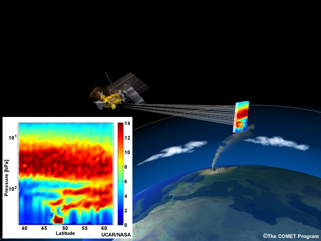
Description:
Image depicting the different scanning methods used by nadir and limb sensors on satellites monitoring pollution plumes
File Name:
nadir_limb.jpg
Credits:
© The COMET Program / NASA
Copyright Terms:
COMET Standard Terms of Use
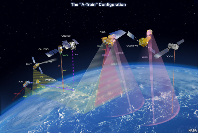
Description:
Conceptual graphic showing the formation of satellites, which currently includes Aqua, CloudSat, Cloud-Aerosol Lidar and Infrared Pathfinder Satellite Observations (CALIPSO) and Aura satellites, that cross the equator at around 1:30 p.m. local time each afternoon. The "A" stands for "afternoon."
File Name:
NASA_A-Train.jpg
Credits:
NASA
Copyright Terms:
COMET Standard Terms of Use
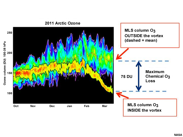
Description:
Arctic ozone column data from the Microwave Limb Sounder (MLS) on NASA's Aura (2011)
File Name:
nasa_aura.jpg
Credits:
NASA
Copyright Terms:
COMET Standard Terms of Use
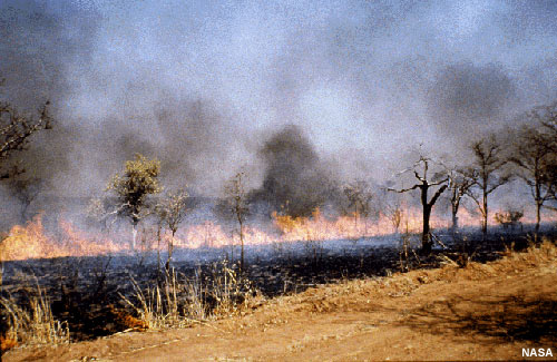
Description:
Biomass burning, including forest fires and the burning of fields in the tropics, is a large source of pollutants.
File Name:
nasa_biomass_burn.jpg
Credits:
NASA
Copyright Terms:
COMET Standard Terms of Use
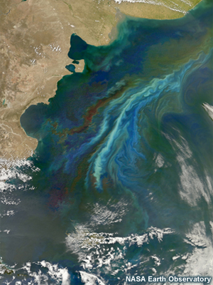
Description:
This satellite image reveals a massive phytoplankton bloom off of the Atlantic coast of Patagonia in December 2010. Scientists used seven spectral bands to highlight the differences in the plankton communities across this swath of ocean.
File Name:
NASA_EO_Patagonia_Bloom.jpg
Credits:
NASA Earth Observatory
Copyright Terms:
Creative Commons Attribution 2.0 Generic
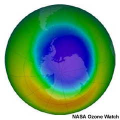
Description:
False-color view of the monthly-averaged total ozone over the Antarctic pole
File Name:
nasa_o3hole.jpg
Credits:
NASA Ozone Watch
Copyright Terms:
COMET Standard Terms of Use
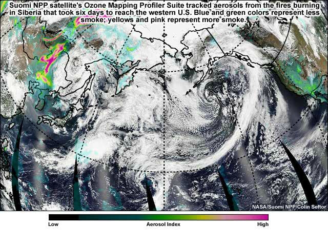
Description:
Suomi NPP satellite's Ozone Mapping Profiler Suite tracked aerosols from the fires burning in Siberia that took six days to reach the western U.S. The blue and green colors represent less smoke; yellows and pink represent more smoke. Smoke density is identified by the level of transparency in the coloration.
File Name:
nasa_omps_asian_fires_0001.htm
Credits:
NASA/Suomi NPP/Colin Seftor
Copyright Terms:
COMET Standard Terms of Use
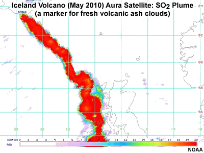
Description:
During the eruption of Iceland's Eyjafjallajökull volcano in early May 2010, the Ozone Monitoring Instrument on NASA's Aura showed the eruption's sulfur dioxide plume, which is a marker for fresh volcanic ash clouds.
File Name:
nasa_volc_so2.jpg
Credits:
NOAA
Copyright Terms:
COMET Standard Terms of Use
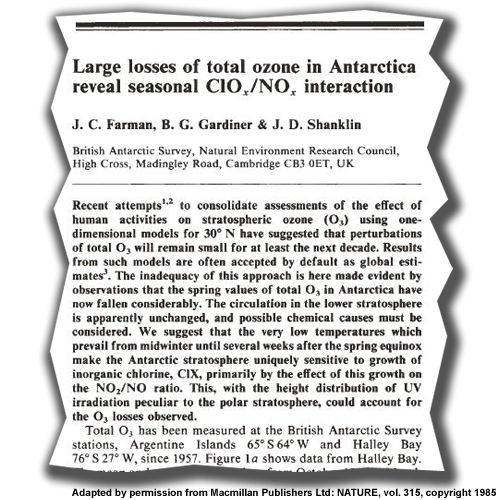
Description:
Extract of the first journal paper to describe the ozone hole over Antarctica
File Name:
nature_o3.jpg
Credits:
Adapted by permission from Macmillan Publishers Ltd: NATURE, vol. 315, copyright 1985
Copyright Terms:
COMET Standard Terms of Use
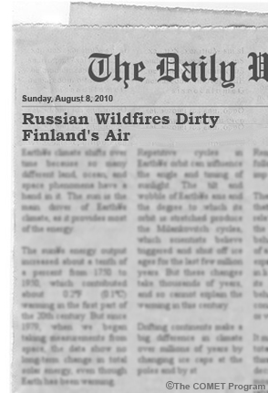
Description:
Newspaper article with headline "Russian Wildfires Dirty Finland's Air"
File Name:
news1.jpg
Credits:
© The COMET Program
Copyright Terms:
COMET Standard Terms of Use
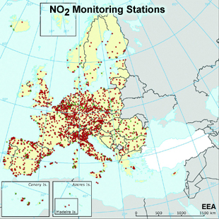
Description:
NO2 monitoring stations in Europe
File Name:
no2_stations.jpg
Credits:
EEA
Copyright Terms:
COMET Standard Terms of Use
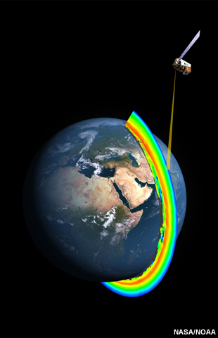
Description:
The Earth's ozone layer as seen by Suomi NPP
File Name:
noaa_omps.jpg
Credits:
NASA/NOAA
Copyright Terms:
COMET Standard Terms of Use
Description:
Illustration of the concept of occultation viewing/measurements
File Name:
occultation.jpg
Credits:
© The COMET Program
Copyright Terms:
COMET Standard Terms of Use
Description:
OCO-2 Orbiting Carbon Observatory
File Name:
OCO_high_res_Observatory.jpg
Credits:
NASA/JPL
Copyright Terms:
COMET Standard Terms of Use
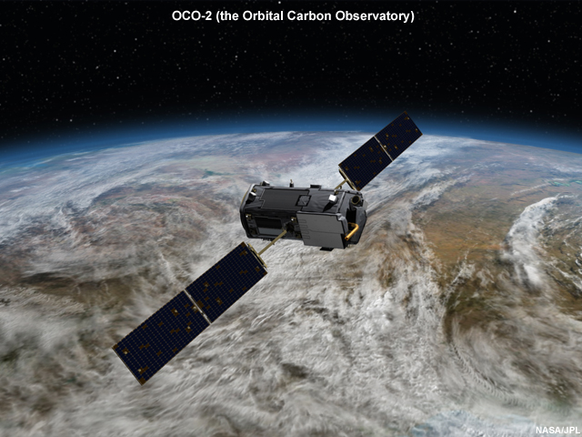
Description:
Artist's drawing of OCO-2 (the Orbital Carbon Observatory)
File Name:
OCO_spacecraft_large.jpg
Credits:
NASA/JPL
Copyright Terms:
COMET Standard Terms of Use
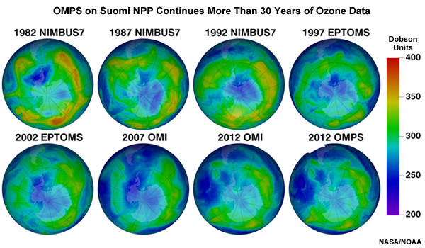
Description:
Ozone measurements from different satellites from 1982 to 2012 with OMPS
File Name:
omps_heritage.jpg
Credits:
NASA / NOAA
Copyright Terms:
COMET Standard Terms of Use
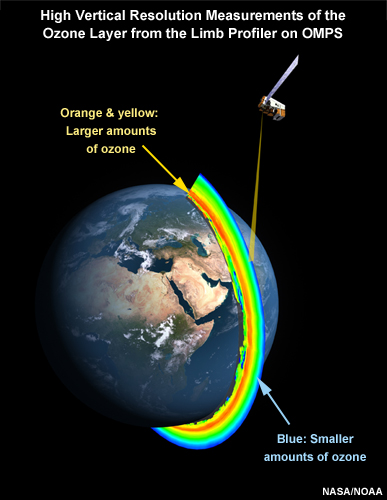
Description:
High vertical resolution measurements of the ozone layer from the limb profiler on OMPS
File Name:
omps_ozone.jpg
Credits:
NASA/NOAA
Copyright Terms:
COMET Standard Terms of Use
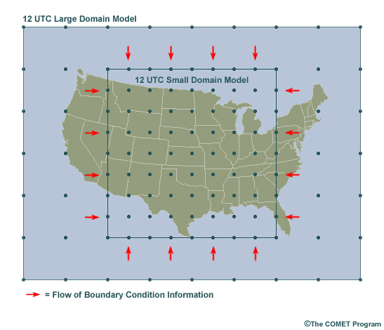
Description:
Conceptual diagram showing boundary conditions affecting the inside domain in a nested model.
File Name:
oneway.jpg
Credits:
©The COMET Program
Copyright Terms:
COMET Standard Terms of Use
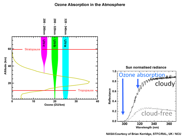
Description:
Ozone absorption in the atmosphere
File Name:
ozone_abs_atm.jpg
Credits:
NASA/Courtesy of Brian Kerridge, STFC/RAL, UK / NCU
Copyright Terms:
COMET Standard Terms of Use
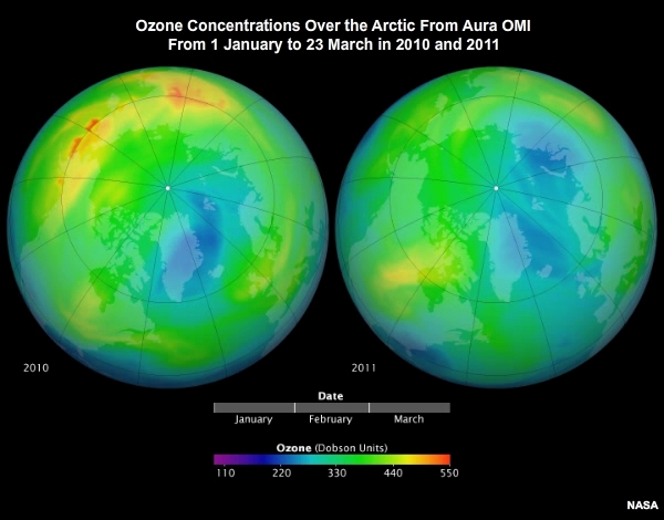
Description:
Ozone concentrations over the Arctic from Aura OMI from 1 January to 23 March in 2010 and 2011
File Name:
ozone_change_arctic.mp4
Credits:
NASA
Copyright Terms:
COMET Standard Terms of Use
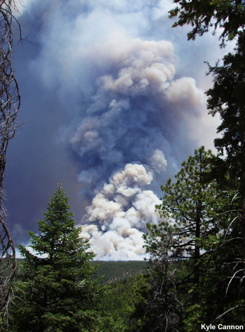
Description:
Large smoke column rises over a pine forest.
File Name:
P6210145.jpg
Credits:
Kyle Cannon
Copyright Terms:
COMET Standard Terms of Use
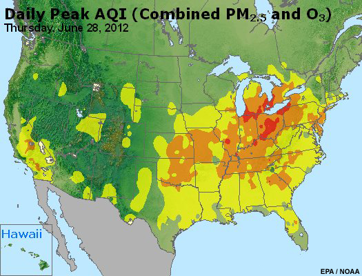
Description:
Graphical daily peak AQI (Air Quality Index) forecasts for the combination of PM2.5 and O3 for the entire U.S.
File Name:
peak_aqi_usa_28jun12.jpg
Credits:
EPA / NOAA
Copyright Terms:
COMET Standard Terms of Use
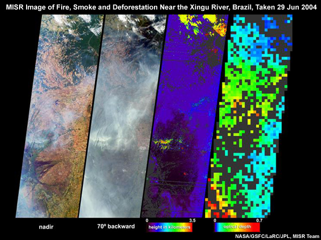
Description:
MISR image of fire, smoke and deforestation near the Xingu River, Brazil, taken 29 Jun 2004
File Name:
PIA04362_modest.jpg
Credits:
NASA/GSFC/LaRC/JPL, MISR Team
Copyright Terms:
COMET Standard Terms of Use
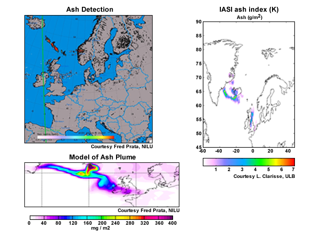
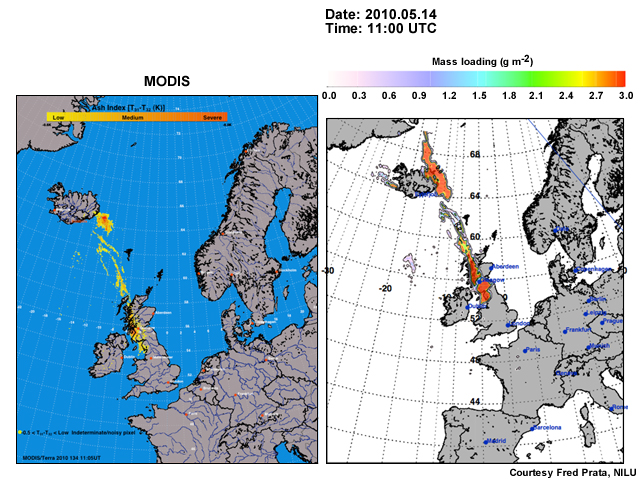
Description:
Upper left image--ash detection, right image--IASI ash index, lower left image--model of ash plume
File Name:
prata_ash.jpg
Credits:
Right image: Courtesy L. Clarisse, ULB, other images: Courtesy Fred Prata, NILU
Copyright Terms:
COMET Standard Terms of Use
Description:
MODIS ash images from 2010 Eyjafjallajökul volcanic eruption
File Name:
prata_ash_modis.jpg
Credits:
Courtesy Fred Prata, NILU
Copyright Terms:
COMET Standard Terms of Use
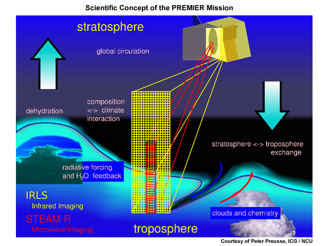
Description:
Conceptual graphic describing the PREMIER satellite mission carrying the IRLS limb-viewing infrared Fourier transform spectrometer and the STEAM-R limb-viewing millimetre wave emission radiometer
File Name:
preusse_targets_strtrop.jpg
Credits:
Courtesy of Peter Preusse, ICG / NCU
Copyright Terms:
COMET Standard Terms of Use
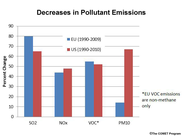
Description:
Graph showing decreases in pollutant emissions in the EU (1990-2009) and U.S. (1990-2010)
File Name:
reductions.jpg
Credits:
© The COMET Program
Copyright Terms:
COMET Standard Terms of Use

Description:
Photo of Dr. Rosemary Munro, EUMETSAT
File Name:
rose.jpg
Credits:
© EUMETSAT, 2012
Copyright Terms:
COMET Standard Terms of Use
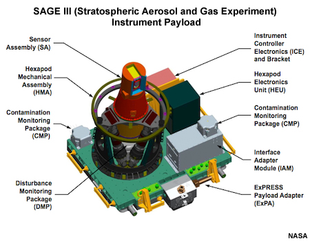
Description:
SAGE III Instrument Payload
File Name:
SAGE3.jpg
Credits:
NASA
Copyright Terms:
COMET Standard Terms of Use
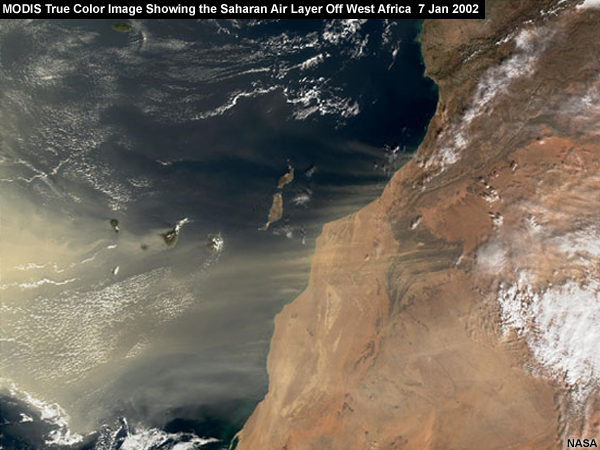
Description:
MODIS true color image showing the Saharan air layer off West Africa on 7 Jan 2002
File Name:
sal_modis.jpg
Credits:
NASA
Copyright Terms:
COMET Standard Terms of Use
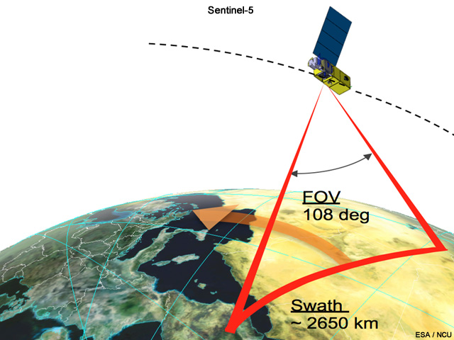
Description:
Conceptual image of the proposed Sentinel-5 satellite
File Name:
sentinel5.jpg
Credits:
ESA / NCU
Copyright Terms:
COMET Standard Terms of Use
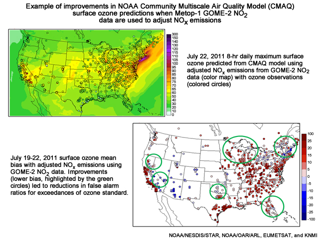
Description:
Example of improvements in NOAA Community Multiscale Air Quality Model (CMAQ) surface ozone predictions when Metop-1 GOME-2 NO2 data are used to adjust NOx emissions
File Name:
sk_pollute.jpg
Credits:
NOAA/NESDIS/STAR, NOAA/OAR/ARL, EUMETSAT, and KNMI
Copyright Terms:
COMET Standard Terms of Use
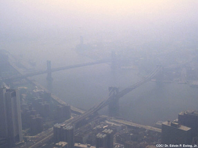
Description:
View from top of World Trade Center of air pollution over Manhattan
File Name:
smogNY.jpg
Credits:
CDC/ Dr. Edwin P. Ewing, Jr.
Copyright Terms:
COMET Standard Terms of Use
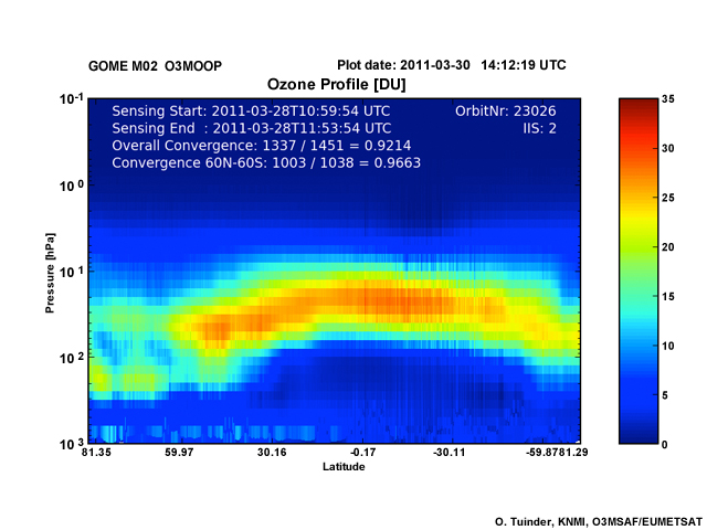
Description:
Arctic ozone profile from the METOP Gome-2 instrument (March 2011)
File Name:
stammes_gome2.jpg
Credits:
O. Tuinder, KNMI, O3MSAF/EUMETSAT
Copyright Terms:
COMET Standard Terms of Use
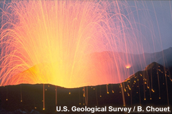
Description:
Close view of Stromboli Volcano erupting incandescent molten lava fragments.
File Name:
strombolian_eruption.jpg
Credits:
U.S. Geological Survey / B. Chouet
Copyright Terms:
COMET Standard Terms of Use
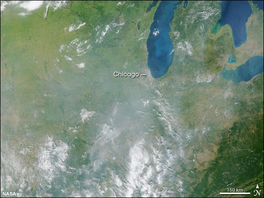
Description:
This image from the Moderate Resolution Imaging Spectroradiometer (MODIS) shows the polluted air like a gray veil over the region southwest of Chicago on September 9, 2002.
File Name:
terra_us_upper_midwest_09sep2002.jpg
Credits:
NASA
Copyright Terms:
COMET Standard Terms of Use

Description:
False-color view of total ozone over the Antarctic pole from 1979 to 2010
File Name:
toms_ozone_1979to2010.mp4
Credits:
NASA
Copyright Terms:
COMET Standard Terms of Use
Description:
CarbonSat’s spectral bands covered by the Imaging Spectrometer
File Name:
ub_carbonsat_spectral.jpg
Credits:
Institute of Environmental Physics of the University of Bremen / Michael Buchwitz, Heinrich Bovensmann and John P. Burrows
Copyright Terms:
COMET Standard Terms of Use
Description:
Cover page of the Handbook for the Montreal Protocol on Substances that Deplete the Ozone Layer
File Name:
unep_monprot.jpg
Credits:
Ozone Secretariat, UNEP / NCU
Copyright Terms:
COMET Standard Terms of Use
Description:
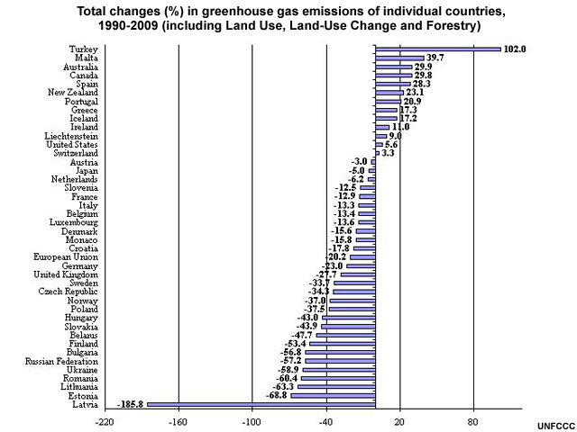
Total changes (%) in greenhouse gas emissions of individual countries, 1990-2009 (including Land Use, Land-Use Change and Forestry)
File Name:
unfccc_changes_including_2010.jpg
Credits:
UNFCCC
Copyright Terms:
COMET Standard Terms of Use
Description:
Ozone forecast for cities along the US East Coast
File Name:
us_03_fcst.jpg
Credits:
NOAA / EPA
Copyright Terms:
COMET Standard Terms of Use
Description:
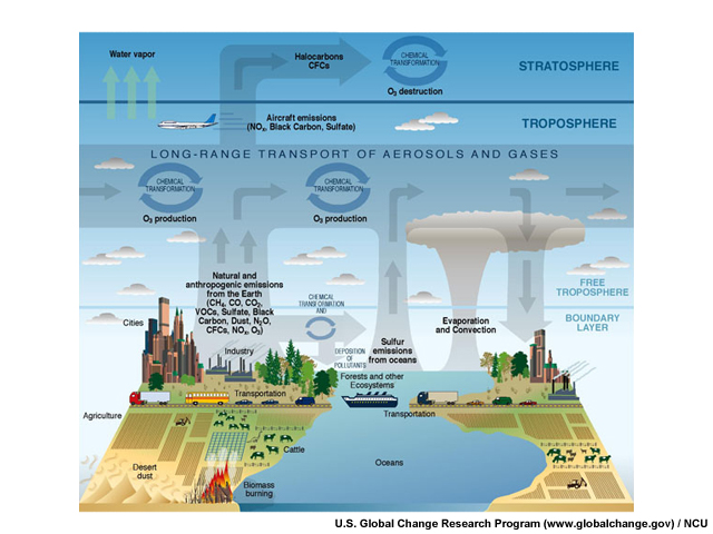
Diagram of air pollution sources and transport mechanisms
File Name:
usgcrp_pollution.jpg
Credits:
U.S. Global Change Research Program (www.globalchange.gov) / NCU
Copyright Terms:
COMET Standard Terms of Use
Description:
Diagram of how long-range pollution transport works in the vertical
File Name:
vert_trans.jpg
Credits:
© The COMET Program
Copyright Terms:
COMET Standard Terms of Use
Description:
Diagram of long-range pollution transport between continents
File Name:
vert_trans_global.jpg
Credits:
© The COMET Program
Copyright Terms:
COMET Standard Terms of Use
Description:
A terraced rice-farm is near the slopes of the erupting Mayon volcano. Ash plume and projectiles are seen on the volcanic cone.
File Name:
volcano_agriculture.jpg
Credits:
Creative Commons IRRI Images
Copyright Terms:
Creative Commons Attribution 2.0 Generic
Description:
Impact of column-average methane mixing ratios for inverse modelling of surface fluxes
File Name:
Weele_Flux_Scia.jpg
Credits:
© M. van Weele, KNMI, The Netherlands
Copyright Terms:
COMET Standard Terms of Use
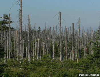
Description:
Effects of acid rain, woods, Jizera Mountains, Czech Republic
File Name:
wiki_acid_rain_woods1.jpg
Credits:
Public Domain
Copyright Terms:
COMET Standard Terms of Use
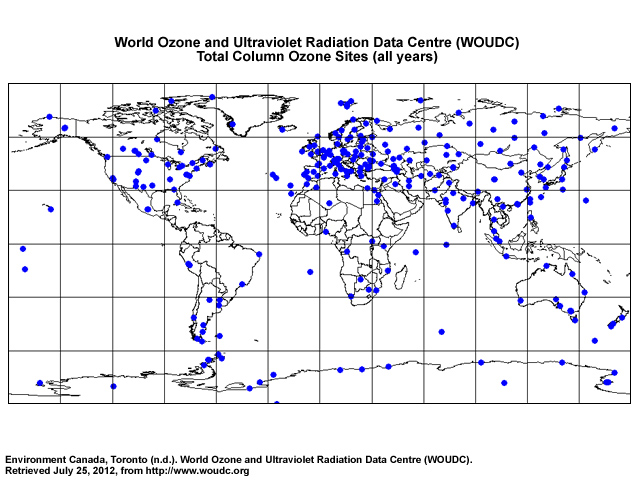
Description:
World Ozone and Ultraviolet Radiation Data Centre (WOUDC) map of total column ozone sites
File Name:
woudc_tot.jpg
Credits:
Environment Canada, Toronto (n.d.). World Ozone and Ultraviolet Radiation Data Centre (WOUDC). Retrieved July 25, 2012, from http://www.woudc.org
Copyright Terms:
COMET Standard Terms of Use