Media elements used in this module are protected by a variety of copyright licenses. Please use the "copyright terms" link associated with each item below for more information.
Click an image to view it at full size in a new browser window/tab.
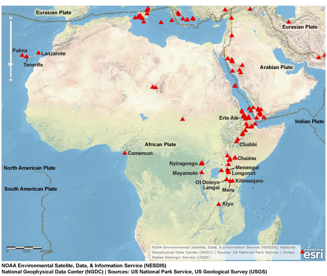
description:
map showing tectonic plates and major volcanoes in and near Africa
file name:
africa_volcanoes.jpg
credits:
NOAA Environmental Satelite, Data, & Information Service (NESDIS), National Geophysical Data Center (NGDC) | Sources: US National Park Service, US Geological Survey (USGS)
copyright terms:
COMET Standard Terms of Use
|
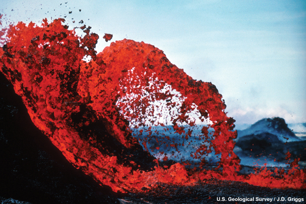
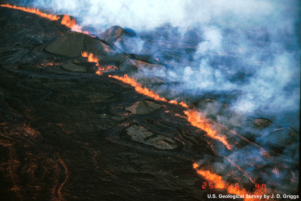
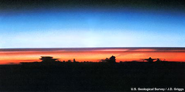
description:
Eruption of Kilauea Volcano beginning in 1983. Arching lava fountain - bright red lava is arching from the side of a slope and to the right.
file name:
arching_lava_fountain.jpg
credits:
U.S. Geological Survey / J. D. Griggs
copyright terms:
COMET Standard Terms of Use
|
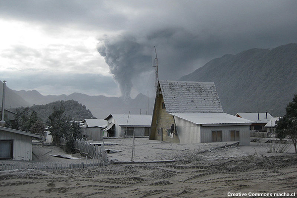
description:
Houses buried in volcanic ash up to their first-floor windows in a town near the Chaiten volcano. The volcano plume is in the background.
file name:
ash_Chaiten.jpg
credits:
Creative Commons macha.cl
copyright terms:
Creative Commons Attribution-ShareAlike 2.0
|
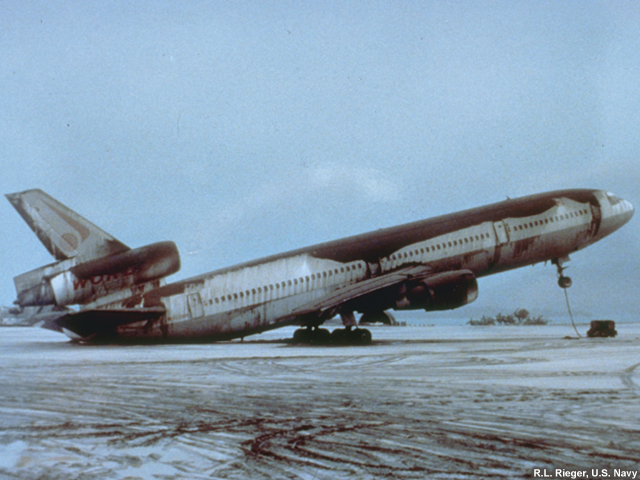
description:
Ashfall on a commercial airplane in the Phillipines after the eruption of Mt. Pinatubo. So much ash is on the airplane that the tail has tipped to ground.
file name:
Ashfall_Airplane.jpg
credits:
R.L. Rieger, U.S. Navy
copyright terms:
COMET Standard Terms of Use
|

description:
During the past 4,000 years eruptions have occurred at an average rate of about 2 per century. This chart shows 13 volcanoes on a map of Washington, Oregon, and northern California and time lines for each showing the ages of their eruptions.
file name:
cascade_eruptions.jpg
credits:
U.S. Geological Survey / Bobbie Myers and Carolyn Driedger
copyright terms:
COMET Standard Terms of Use
|

view/save .mp4 file
description:
A video of lava rising out of a small vent. As night falls, the red glow of the lava outlines the lava segments.
file name:
effusion_flow_july_13_2007_USGS.mp4
credits:
U.S. Geological Survey
copyright terms:
COMET Standard Terms of Use
|
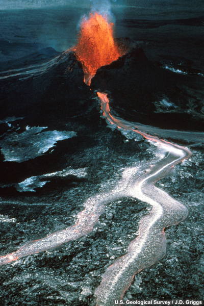
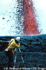
description:
Fountaining and lava flow from Pu'u O'o.
file name:
effusive_eruption.jpg
credits:
U.S. Geological Survey / J.D. Griggs
copyright terms:
COMET Standard Terms of Use
|
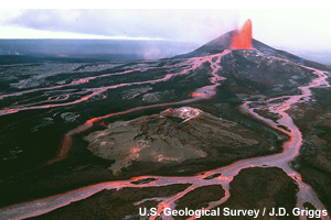
description:
Braided lava flows spread from a lava fountain on the side of Pu`u `O`o cone.
file name:
effusive_Lavaflow.jpg
credits:
U.S. Geological Survey / J. D. Griggs
copyright terms:
COMET Standard Terms of Use
|
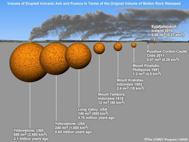
description:
schematic showing representative sizes of past and recent eruptions
file name:
eruption_comparison_v2.jpg
credits:
(c)The COMET Program/USGS
copyright terms:
COMET Standard Terms of Use
|
description:
This is a view from space of the eruption of Sarychev volcano. The plume appears to be a combination of brown ash and white steam. The vigorously rising plume gives the steam a bubble-like appearance.
file name:
eruption_from_space_lrg.jpg
credits:
NASA
copyright terms:
COMET Standard Terms of Use
|
|
|
|
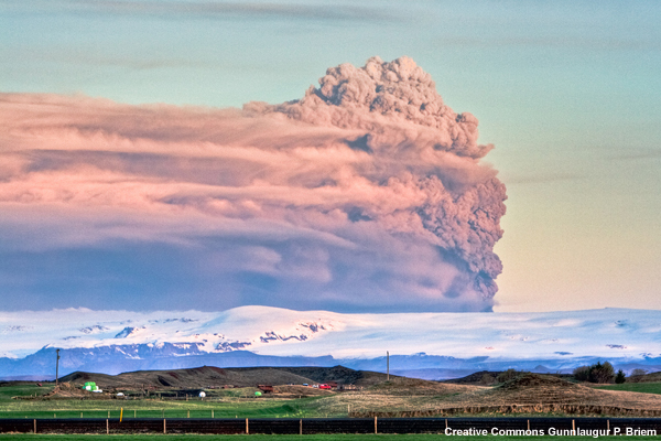
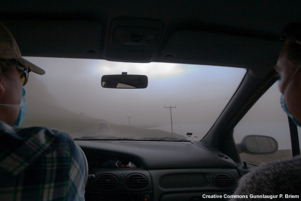
description:
Dark-grey ash plume rises high above Iceland, in this early morning photo of Eyjafjalljokull' s eruption.
file name:
eyjafjallajokull01.jpg
credits:
Creative Commons Gunnlaugur P. Briem
copyright terms:
Creative Commons Attribution-ShareAlike 2.0
|

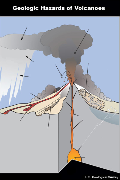
description:
A graphic showing hazards associated with volcanic eruptions. 11 hazards are shown:lava flow, pyroclastic flow, lahar, lava dome collapse, tephra, eruption column, eruption cloud, acid rain, bombs, landslide, fumaroles.
file name:
geologic_hazards_at_volcanoes.jpg
credits:
U.S. Geological Survey
copyright terms:
COMET Standard Terms of Use
|
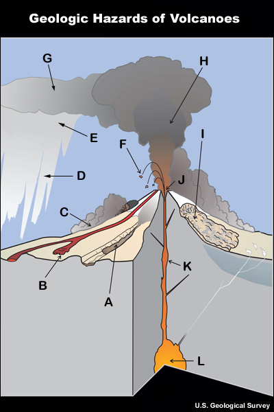
description:
A graphic showing hazards associated with volcanic eruptions. 11 hazards are shown:lava flow, pyroclastic flow, lahar, lava dome collapse, tephra, eruption column, eruption cloud, acid rain, bombs, landslide, fumaroles.
file name:
geologic_hazards_at_volcanoes_dd.jpg
credits:
U.S. Geological Survey
copyright terms:
COMET Standard Terms of Use
|
description:
A graphic showing hazards associated with volcanic eruptions. 11 hazards are shown:lava flow, pyroclastic flow, lahar, lava dome collapse, tephra, eruption column, eruption cloud, acid rain, bombs, landslide, fissures.
file name:
geologic_hazards_at_volcanoes_quiz.jpg
credits:
U.S. Geological Survey
copyright terms:
COMET Standard Terms of Use
|
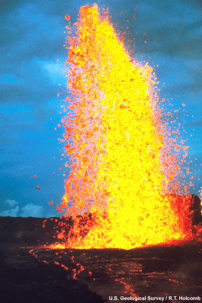
description:
Mauna Ulu fountain, viewed from the north rim. Similar to a fountain of foam where the base is solid and the top of the fountain breaks up into smaller chunks.
file name:
h_lava_fount.jpg
credits:
U.S. Geological Survey / R.T. Holcomb
copyright terms:
COMET Standard Terms of Use
|
description:
Magma fountaining at fissures during the 1984 eruption of Mauna Loa Volcano.
file name:
hawaii_vo00466.jpg
credits:
U.S. Geological Survey / J. D. Griggs
copyright terms:
COMET Standard Terms of Use
|
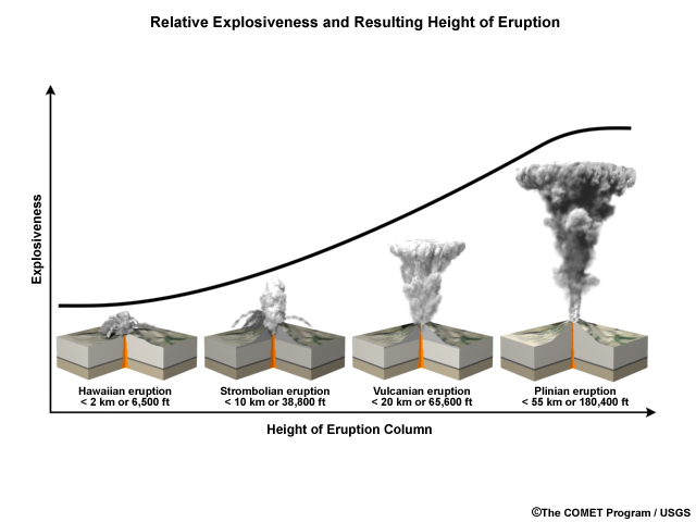
description:
Graphic compares the height of an eruption column (ash plume) in ft/km to its explosiveness; that is, the more explosive an eruption, the higher the ash/water and aerosols are ejected into the atmosphere.
file name:
Height_of_eruption.jpg
credits:
The COMET Program/USGS
copyright terms:
COMET Standard Terms of Use
|
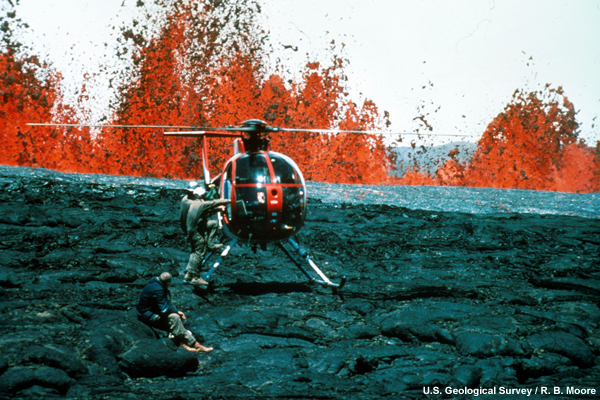
description:
Hawaiian Volcano Observatory geologists at lava fountains. Helicopters provided access to remote areas of the eruption and were essential for safety. The lava fountain is rising near the helicopter.
file name:
helicopter_lava.jpg
credits:
U.S. Geological Survey / R. B. Moore
copyright terms:
COMET Standard Terms of Use
|
|
|
view/save .mp4 file
description:
A video of the 1980 explosive volcanic eruption of Mt. St. Helen's. The footage is taken from an airplane circling the plume. At one point, lightning can be seen.
file name:
MSH_MOVIE_eruption_30Years.mp4
credits:
U.S. Geological Survey
copyright terms:
COMET Standard Terms of Use
|
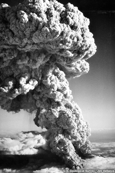
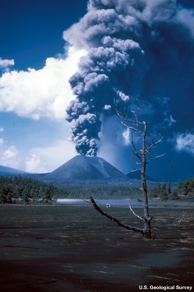
description:
Mount St. Helens 1980 explosive eruption with voluminous plume of tephra.
file name:
MSH80_eruption_mount_st_helens_05_18_80_bw_med.jpg
credits:
U.S. Geological Survey
copyright terms:
COMET Standard Terms of Use
|

description:
A lahar (the dark deposit on the snow) flowing from the crater of Mt St Helens into the North Fork Toutle River valley.
file name:
MSH82_lahar_from_march_82_eruption_03_21_82_med.jpg
credits:
U.S. Geological Survey / Tom Casadevall
copyright terms:
COMET Standard Terms of Use
|
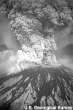
description:
Third pulse of Mount St. Helens eruption of July 22. Aerial view taken at 1907 PDT looking south, showing spreading mushroom top on convectively rising column and cloud of ash rising from an ash flow that has swept northward out of volcano's crater amphitheater. North west slope of volcano no visible at lower right. Column height about 15 km.
file name:
mt_st_helens.jpg
credits:
U.S. Geological Survey / Jim Vallance
copyright terms:
COMET Standard Terms of Use
|
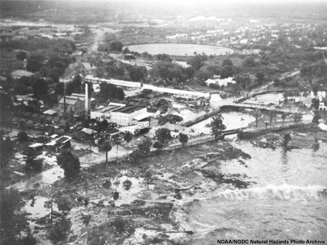
description:
Hilo, Hawaii. Aerial view showing extent of innudation in area of Hilo Electric Company resulting from first wave as secondary wave approaches the area.
file name:
ngdc_1946alaska_shorefront.jpg
credits:
NOAA/NGDC Natural Hazards Photo Archive
copyright terms:
COMET Standard Terms of Use
|
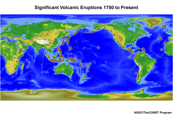
description:
map showing locations of significant volcanic eruptions worldwide since 1750
file name:
ngdc_map_volcanos.jpg
credits:
NGDC/The COMET Program
copyright terms:
COMET Standard Terms of Use
|
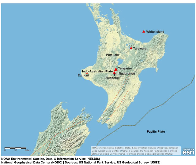
description:
map showing tectonic plates and major volcanoes in and near New Zealand
file name:
nz_volcanoes.jpg
credits:
NOAA Environmental Satelite, Data, & Information Service (NESDIS), National Geophysical Data Center (NGDC) | Sources: US National Park Service, US Geological Survey (USGS)
copyright terms:
COMET Standard Terms of Use
|
description:
A volcanic plume rises high above Mt. Paricutin, Mexico.
file name:
paricutin_volcano.jpg
credits:
U.S. Geological Survey
copyright terms:
COMET Standard Terms of Use
|
description:
Geologist measuring the height of a lava fountain.
file name:
person_lava_fount.jpg
credits:
U.S. Geological Survey / J. D. Griggs
copyright terms:
COMET Standard Terms of Use
|
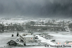
description:
Ash from Mt. Pinatubo's eruption covers many buildings and a hospital in the foreground. The sky is grey with ash, all greenery is covered in grey too.
file name:
Pinatubo_Ash_at_Hospital.jpg
credits:
U.S. Geological Survey
copyright terms:
COMET Standard Terms of Use
|
description:
Space Shuttle photograph of the Earth over South America taken on August 8, 1991, showing double layer of Pinatubo aerosol cloud (dark streaks) above high cumulonimbus tops
file name:
Pinatubo_dust_layer from STS_43.jpg
credits:
U.S. Geological Survey
copyright terms:
COMET Standard Terms of Use
|

description:
A cross-section illustrating the main type of plate boundaries - convergent, divergent, transform and their likely physical manifestations.
file name:
plate_tectonics.jpg
credits:
U.S. Geological Survey / map by José F. Vigil
copyright terms:
COMET Standard Terms of Use
|
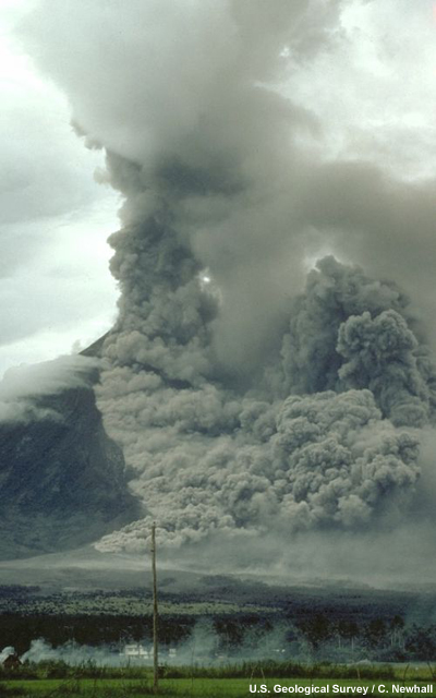
description:
Pyroclastic flow sweeps down the side of Mayon Volcano, Philippines. Note the ground-hugging cloud of ash (lower left) that is billowing from the pyroclastic flow and the eruption column rising from the top of the volcano.
file name:
pyro_flow_large.jpg
credits:
U.S. Geological Survey / C. Newhall
copyright terms:
COMET Standard Terms of Use
|
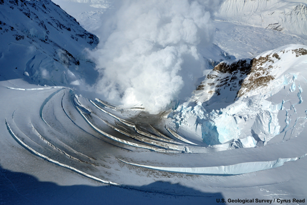
description:
The glacier that filled the crater of Mt. Redoubt is collapsing because of the increased temperature underneath. This photo was taken on March 21, 2009, the day before Redoubt first erupted.
file name:
Redoubt3_21_2009_Cyrus_Read.jpg
credits:
U.S. Geological Survey / Cyrus Read
copyright terms:
COMET Standard Terms of Use
|

description:
Volcanic arcs and oceanic trenches partly encircling the Pacific Basin form the so-called Ring of Fire, a zone of frequent earthquakes and volcanic eruptions. The trenches are shown in blue-green. The volcanic island arcs, although not labelled, are parallel to, and always landward of, the trenches.
file name:
ring_of_fire.jpg
credits:
U.S. Geological Survey
copyright terms:
COMET Standard Terms of Use
|

description:
Close view of a single ash particle from the eruption of Mount St. Helens; image is from a scanning electron microscope (SEM). The tiny voids or holes are called vesicles and were created by expanding gas bubbles during the eruption of magma. (USGS description)
file name:
SarnaSem.jpg
credits:
U.S. Geological Survey / A.M. Sarna-Wojcicki
copyright terms:
Creative Commons Attribution 2.0 Generic
|
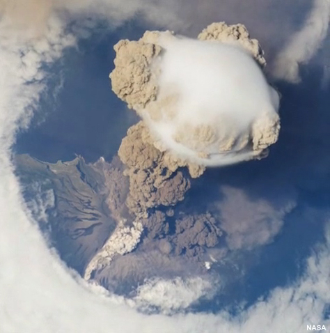
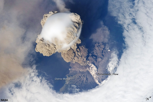
view/save .mp4 file
description:
International Space Station view of Sarychev Volcano (Kuril Islands, northeast of Japan) in an early stage of eruption on June 12, 2009. The ash plume is viewed from above and it has pierced the cloud cover above the volcano. A pyroclastic flow is visible on the volcano's flank.
file name:
sarychev_oblique_final_H264.mp4
credits:
NASA
copyright terms:
COMET Standard Terms of Use
|
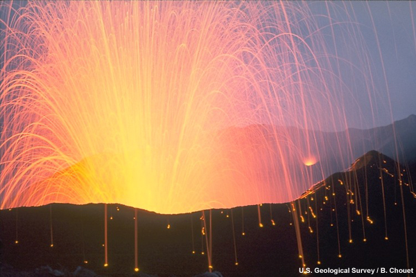
description:
Close view of Stromboli Volcano erupting incandescent molten lava fragments.
file name:
strombolian_eruption.jpg
credits:
U.S. Geological Survey / B. Chouet
copyright terms:
COMET Standard Terms of Use
|
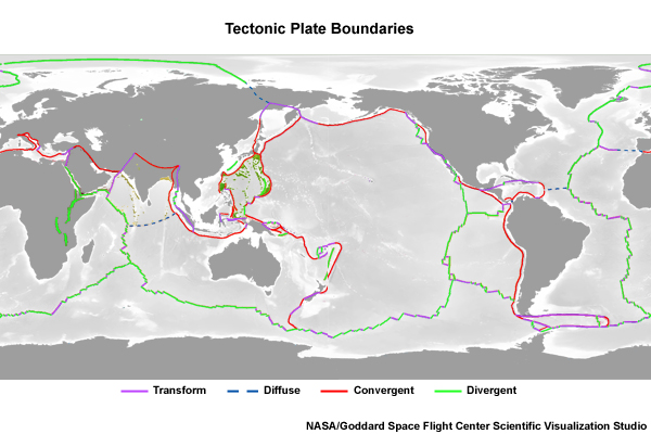
description:
A map of the world showing the tectonic plate boundaries and the direction of their motion.
file name:
Tectonic_plates_boundaries_detailed.jpg
credits:
Creative Commons Eric Gaba
copyright terms:
Creative Commons Attribution-ShareAlike 2.5
|
|
|
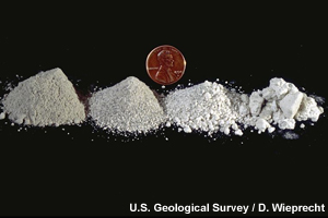
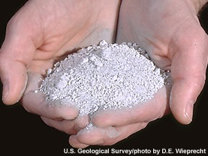
description:
Different types of tephra are compared against the size of a US penny.
file name:
tephra_penny.jpg
credits:
U.S. Geological Survey / D. Wieprecht
copyright terms:
COMET Standard Terms of Use
|
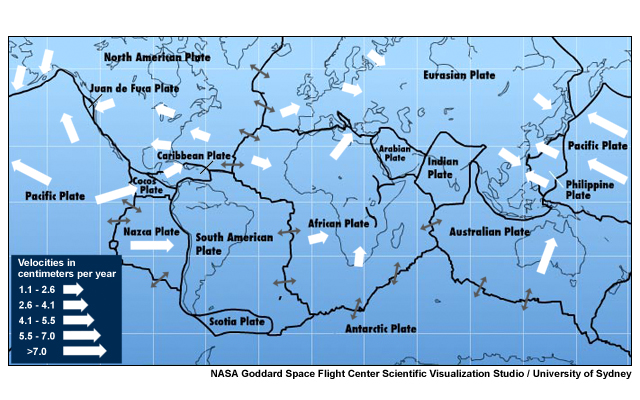
description:
map showing Earth's tectonic plates with motion velocities marked
file name:
usgs_platemotion.jpg
credits:
NASA Goddard Space Flight Center Scientific Visualization Studio/University of Sydney
copyright terms:
COMET Standard Terms of Use
|
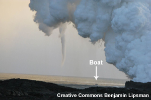
description:
A volcanic plume on the Hawaiian coast engenders a funnel cloud.
file name:
volacone_funnel_cloud.jpg
credits:
Creative Commons Benjamin Lipsman
copyright terms:
Creative Commons Attribution 2.0 Generic
|
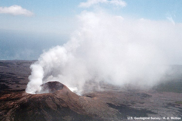
description:
Sulfur dioxide and other volcanic gases rise from the Pu`u `O`o vent on Kilauea Volcano, Hawai`i
file name:
volc_gas_large.jpg
credits:
U.S. Geological Survey / K. A. McGee
copyright terms:
COMET Standard Terms of Use
|
|
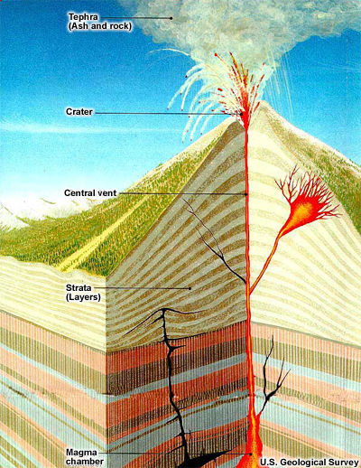
description:
A cross-section of a typical volcano during an eruption. Starting at the magma chamber, magma rises through strata (rock layers) to the surface, following one or more conduits. While most magma rises to the top of the volcano and erupts through the central vent, other magma may follow diverging conduits and erupt on the flanks of the volcano. Some magma may never reach the surface, intruding laterally into the strata instead.
file name:
volcano_structure.jpg
credits:
U.S. Geological Survey
copyright terms:
COMET Standard Terms of Use
|
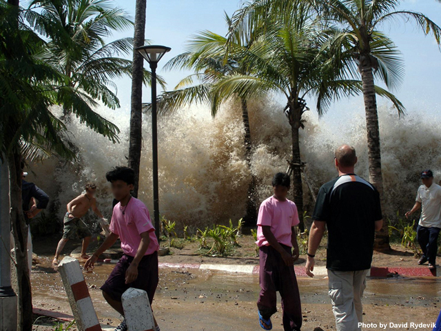
description:
The first wave of the 2004 Indian Ocean tsunami hits Ao Nang, Thailand.
file name:
Wiki_2004-tsunami.jpg
credits:
Photo by David Rydevik
copyright terms:
COMET Standard Terms of Use
|