
Table of Contents
Introduction
Introduction » Eyjafjallajökull Volcano (2010)
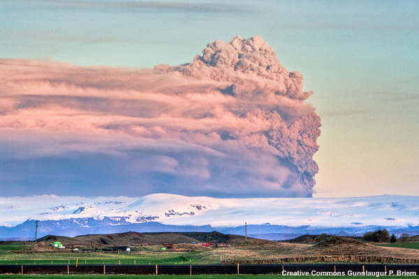
The 2010 eruption of Eyjafjallajökull (pronounced AY-yah-fyat-lah-YO-kutl) was a series of volcanic events that, although relatively small, caused an enormous disruption of air travel across western and northern Europe.
A period of high seismic activity began in the vicinity of Eyjafjallajokull glacier during the later part of 2009. The activity continued to intensify and on the evening of 20 March 2010, a fissure eruption began with lava jets fountaining upwards of 330 ft (~100 m). Though lava was limited to the immediate vicinity, some volcanic ash fell within a mile or so west of the eruption site. The sequence of eruption tremors and venting continued for the next three weeks.
Shortly after midnight on 14 April, an eruption from a new vent under Eyjafjallajökull's ice-filled crater discharged volcanic ash to 20,000 ft (~6000 m). For the next five days, Eyjafjallajokull continued to erupt and expel ash from 15,000 to 30,000 ft (~4500 to 9000 m).

During the time of the eruption a deep low pressure system south of Iceland steered the volcanic ash southward and eastward toward the European continent. The resulting ash cloud and its projected path disrupted air travel to, from, and within Europe and cost nearly $4.7 billion (US) in lost gross domestic product (GDP) worldwide.
- Lost GDP:
- $2.6 billion for Europe
- $957 million to the Americas
- $591 million to the Middle East and Africa
- $517 million to Asia
- 2.4 percent drop in worldwide passenger demand for air travel
Eruptions continued into mid-May increasing the total loss in worldwide GDP by another 5% to over $5 billion.
Introduction » Mount Pinatubo (1991)
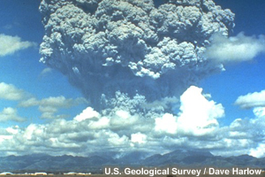
The island of Luzon in the Philippines has thirteen active volcanoes; one of those is Mount Pinatubo (pĭn'ətū'bō). Mount Pinatubo is located approximately 55 mi (90 km) northwest of Manila. In June 1991, it erupted sending large amounts of volcanic ash, sulfur dioxide, and other gases high into the atmosphere. It was the second largest volcanic eruption of the 20th century.
Within two hours of Mount Pinatubo's eruption, volcanic ash and sulfur dioxide rose to an altitude of over 20-25 miles (35-40 km) and the cloud grew to more than 250 miles (400 km) wide. Furthermore, typhoon Yunya was passing 45 miles (75 km) northeast of Mount Pinatubo and brought heavy rain to the area. Volcanic ash mixed with the rain creating a “shower of tephra” (ash and larger particles) that fell across parts of the island of Luzon. The depth of ash deposits ranged from approximately 13 in (33 cm) near the summit to 2 in (5 cm) over a 1500 mi2 (4000 km2) area downwind.
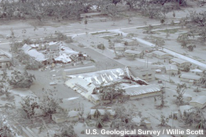
The eruption lasted nine hours and the human impacts were staggering:
- An estimated 800 people died
- Nearly $500M (US) in property and economic damage
- Around 5000 homes were destroyed and another 70,000 were damaged
Nearly half of all casualties were caused by roofs that collapsed under the weight of the ash. Additional deaths and damage were caused by lahars (an Indonesian term) — flows of cement-like mud that formed when the heavy rain mixed with the pyroclastic material. The ongoing monitoring of Mount Pinatubo and subsequent timely warnings averted a larger loss of life.
In addition to the ash, Mount Pinatubo ejected sulfur dioxide gas into the upper atmosphere. The sulfur dioxide mixed with water and hydroxides in the atmosphere to become sulfuric acid aerosol. This aerosol cloud circled the earth in 14-21 days and covered the planet within a year (Mount Hudson, located in southern Chile, erupted from August to October 1991 and contributed a large amount of ash and sulfur dioxide as well). The results of the sulfuric acid aerosol cloud overspreading the globe:
- Reflected a portion of the earth's incoming sunlight back to space and lowered worldwide surface temperatures an average of 1.0° F (0.5° C) in 1992 and 1993.
- Promoted further stratospheric ozone depletion, resulting in a record Antarctic ozone hole.
- Increased scattering of sunlight causing brilliant sunrises and sunsets for years around the globe.
- Longer term damage to aircraft and engines including crazing of acrylic airplane windows, premature fading of polyurethane paint, and accumulation of sulfate deposits on engines.
Introduction » Mammoth Mountain: An Example of an Explosive Eruption
“Ash clouds are not an everyday issue and they do not provide frequent hazard. But if encountered, volcanic ash can spoil your entire day”
Donald D. Engen, VADM USN RetiredIntroductory Remarks for the First International Symposium on Volcanic Ash and Aviation Safety, Seattle, Washington, July 1991
So, at this point you are probably asking yourself just why you need to know this? Whenever there’s a natural disaster, weather forecasters are among the first to be called upon for information and perhaps even advice on how to mitigate impacts. This is regardless of whether or not the natural disaster is weather-related. The forecaster on duty is seen not only as a Meteorologist, but also more generally as an Earth Scientist. You are often the only “expert” available for comment at all hours of the day and night. As the expert, you should:
- understand the basics of volcanism and the impacts of eruptions so as to be able to speak intelligently on the subject
- know where to turn for help in dealing with such inquiries or for additional information on an evolving volcanic eruption
“I was working the midnight shift on April 18, 2008 when a 5.4 magnitude earthquake struck south central Illinois. The telephone lines at the Weather Forecast Office in St. Louis were almost immediately inundated with calls. I was not, and am still not, an expert on earthquakes, but people were frightened and looking for information. The other forecaster on duty and I provided what information and reassurance we could, and this was greatly appreciated by all of the people with whom we spoke.”
Jon CarneyMeteorologist
While a volcano is not likely to erupt in your warning area, there is a very good chance that volcanic ash, or other processes and products related to eruptions, will affect people in your forecast area at some point in time. Consider the eruption of Mount Pinatubo. The more immediate impact from the eruption was to local area residents; however, in the longer term, the sulfate and aerosol clouds that circumnavigated the Earth produced one of the coolest and wettest summers in 1992. Many forecast offices were inundated with telephone calls from people asking why their crops had failed and why there were unusually brilliant sunsets.
As you play the following animation, consider:
- Many of the Earth’s explosive volcanoes are located along the edges of tectonic plates where they are “crunching” together.
- Mammoth Mountain and Cascade Range Volcanoes in California, Oregon, and Washington are located along the eastern periphery of the “Ring of Fire”. (To learn more about the Long Valley caldera visit the USGS link in the Reference section.)
- What would be the impacts of volcanic ash in your forecast area?
- How would you respond?
The left panel in this animation simulates a major eruption on Mammoth Mountain, California, with a significant emission of volcanic ash into the atmosphere. As a result, the Long Valley Observatory issues a Warning about the eruption which prompts the Volcanic Ash Advisory Center to run the HYSPLIT model (shown on the right). It provides a forecast for the transport and dispersion of volcanic ash. This, along with Urgent Pilot Reports and other information, is used by the Volcanic Ash Advisory Center (and Meteorological Watch Office) to produce volcanic ash advisories and SIGMETS.
With a ridge of high pressure over the Pacific Northwest and a low pressure center developing off the southern California coast, HYSPLIT shows an initial westward movement to the ash...at all levels...and heading toward Sacramento and San Francisco. This could cause significant ash accumulation and the US Geological Survey and local emergency managers warn the populace to stay indoors.
As the winds carry the ash offshore and to the south; ships and airplanes headed for facilities along the California coast are diverted to the north. Over time, the ash circles the low and begins to encroach southern California. In 24 to 36 hours, the dispersion model carries the low and mid-level ash across southern California and into the southwest United States. There appears to be a split flow in the upper levels with ash moving both westward and eastward toward Salt Lake City and the Rocky Mountains!
Air traffic destined to cities within the ash cloud area are diverted to airports farther north; or cancelled altogether. By 48 hours, the upper level winds have carried the ash across the Southern Plains and Gulf Coast states disrupting transportation. An eruption of greater magnitude and longer duration could have far reaching climatic impacts.
Course Description
The focus of this series of modules is to provide the operational meteorologist with a thorough understanding of:
- The cause and characteristics of volcanic eruptions
- Detecting volcanic ash
- Forecasting plume movement
- Assessing societal impacts
This knowledge will increase the meteorologist’s situational awareness regarding volcanoes and volcanic eruptions. It also will enable one to interpret the various volcanic products and translate scientific information about volcanoes into terms that are meaningful to the public.
This course provides information to meteorologists serving at an operational weather forecast office that may become the primary point of information dissemination during an eruption. This material also is useful to emergency managers and other decision-makers in various organizations in preparing communities and organizations for potential impacts of a volcanic event.
Specific focus areas include:
- Source: Types of eruptions, types of volcanic ash and aerosols, and the role of plume height.
- Dispersion process: The processes of settling/deposition, scavenging, and transport; the HYSPLIT model and its utility and limitations.
- Detection: Using the satellite IR “split window” technique, using radar and other remote sensing techniques.
- Impacts on the aviation system: Knowing the impacts on different aircraft, issuing forecasts, and providing information to decision-makers.
- Impacts on climate: For both the short and long term.
- Impacts on society: Knowing the potential health effects, both direct (respiratory, skin) and indirect (roadways, buildings), coordination with emergency responders, and impacts on infrastructure.
- Impacts to water: Knowing the effects to local watersheds and supplies, maritime operations.
Objectives
This course has been segmented into four modules that vary in length (from 60 to 90 minutes). The first module, Volcanic Ash: Introduction, introduces volcanoes and provides a platform to launch the other three modules. The second module, Volcanic Ash: Volcanism, provides information on the geological, geophysical, and geochemical processes related to volcanic activity and volcanic ash in the atmosphere and on the ground. The third module, Volcanic Ash: Observation Tools and Dispersion Models, provides information on the tools, the remote sensing resources, and dispersion models used in monitoring volcanic activity and eruptions. The final module, Volcanic Ash: Impacts to Aviation, Climate, Maritime Operations, and Society, provides information related to the impact of volcanic ash on aviation, climate, society, and maritime operations.
Upon successful completion of this course, the meteorologist will be able to:
Volcanism
- Identify the geological elements involved in volcanic eruptions
- Locate currently active volcanoes and major fault lines and plate boundaries in the world
- Describe the process of an explosive volcanic eruption
- Identify eruption types and describe their ash dispersion patterns
- List the most common volcanic hazards and the threats they pose
Observation Tools and Dispersion Models
- Identify dispersion models used to predict air parcel trajectories
- Explain the limitations and strengths of dispersion models
- Use dispersion models to select the most likely air parcel trajectory
- Identify satellite products that depict volcanic eruptions
- Determine ash cloud top from satellite observations and atmospheric soundings
- Describe the strengths and weaknesses of satellite observations
- Identify the presence of volcanic ash using satellite observations
Impacts to Aviation, Climate, Maritime Operations, and Society
- Describe the mechanical and chemical impacts of volcanic ash on aircraft
- Order the steps for appropriate response to the possibility of volcanic ash fall based on the national guidelines
- Prepare a volcanic ash text product for use by external agencies
- Explain the impacts of volcanic ash on atmospheric processes in both the short-term (weather) and in the long-term (climate)
- Discuss the impacts of volcanic ash on the general public
- Discuss the products, such as ash fall advisories and warnings, available to the public
- Discuss the impacts of volcanic ash on ships and facilities
References/Bibliography
USGS: Eyjafjallajökull, Ash, and Eruption Impacts. [Available online from http://volcanoes.usgs.gov/publications/2010/iceland.php]
USGS: Future Eruptions in California's Long Valley Area—What's Likely? [Available online from http://pubs.usgs.gov/fs/fs073-97/ ]
BBC: Iceland volcano cloud: The economic impact. [Available online from http://news.bbc.co.uk/2/hi/8629623.stm]
Oxford Economics, The Economic Impacts of Air Travel Restrictions Due to Volcanic Ash. [Available online from http://www.oxfordeconomics.com/free/pdfs/volcanicupdate.pdf]
Icelandic Meteorological Office (IMO)[Available online at http://en.vedur.is]
Institute of Earth Sciences, University of Iceland: Eruption in Eyjafjallajökull. [Available online from http://www.earthice.hi.is/page/ies_Eyjafjallajokull_eruption]