7.2 Mesoscale Weather Systems »
7.2.4 Tropical Severe Weather »
7.2.4.2 Tornadoes
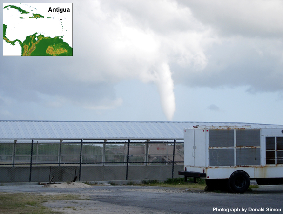
A tornado is a violently rotating column of air, extending from a cumulonimbus or cumulus congestus and reaching the surface (Fig. 7.125). It is the most destructive local scale atmospheric phenomenon.
The estimated speed of most tropical tornado vortices is less than 49 m s-1 (110 mph / 96 kts). Tornadoes last from seconds to more than an hour and their paths range from 100 m to 10s of km. They move at 5-13 m s-1 (10-30 mph/ 9-26 kts).
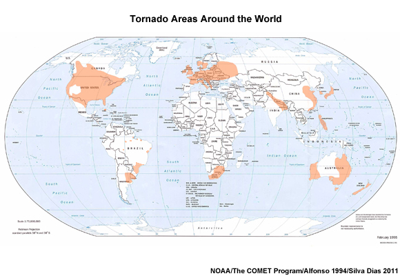
Although relatively rare, tornadoes occur on all continents except Antarctica (Fig. 7.126). They are most common in the plains of North America and Australia. Few tropical places have extensive storm-data reporting like the US. From the tropics, India recorded 42 tornadoes from 1951 to 1980 while Cuba had a mean of 41 tornadoes per year from 1981 to 1985. In Cuba and the Florida peninsula most tornadoes occur during June and July, mainly associated with waterspouts moving onshore and tropical cyclones at landfall. In India and Bangladesh tornadoes are most frequent during April and May and rarely occur during the monsoon. Strong tornadoes are most common in spring and in the late afternoon, but can occur in any season and at any time of day.
Tornado intensity is ranked by an Enhanced Fujita (EF) scale, implemented in 2007 (Table 7.5). The scale is named for Dr. Theodore Fujita who created the first tornado intensity scale in 1971. The original Fujita Scale (F scale) was based on the damage caused by a tornado. The original F-scale was limited by factors such as: categories based on the worst damage, even if done to a single structure, and failure to account for differences in construction.
| EF scale | Class | Wind speed | Description | |
| mph | km h-1 | |||
| EF0 | weak | 65-85 | 105-137 | Gale |
| EF1 | weak | 86-110 | 138-177 | Moderate |
| EF2 | strong | 111-135 | 178-217 | Significant |
| EF3 | strong | 136-165 | 218-266 | Severe |
| EF4 | violent | 166-200 | 267-322 | Devastating |
| EF5 | violent | >200 | > 322 | Incredible |
The EF scale starts with a list of 28 damage indicators that includes a description of the typical construction for that indicator category. Then the âDegree of Damageâ is assessed and related to an expected wind speed range. Tropical tornadoes are usually weak, EF0 or EF1. Only a small percentage of tornadoes are extremely intense, EF3 or greater and they mainly occur with supercells in the midlatitudes.
Tornadoes in the tropics are typically produced by non-supercell thunderstorms, landfalling tropical cyclones, extratropical systems that extend into the tropics, subtropical lows, and hybrids of tropical and extratropical systems.
Non-supercell tornadoes
Most tropical tornadoes are weak and not produced by supercells. âNon-supercell tornadoesâ or âlandspouts,â are associated with mesoscale and local scale circulations in the boundary layer. The parent cloud does not have a mesocyclone as found in supercells.
The necessary conditions for the formation of non-supercell tornadoes seem to include:
(i) a lower tropospheric boundary possessing significant across-front horizontal shear,
(ii) misocyclones developing along the boundary, possibly as a result of horizontal shearing instability,
(iii) rapidly deepening moist convection along the boundary, and
(iv) an atmosphere having only weak vertical shear (compared with supercells).
As illustrated conceptually (Fig. 7.127), usually, convective cells will build and move along the boundary. When a moist convective updraft becomes co-located with a misocyclone, it becomes a tornado through vertical stretching of the vorticity along the boundary. A misocyclone, a small cyclone generated by horizontal shear instability and convergence in the boundary layer, is distinct from the larger and deeper mesocyclone, the rotating updraft in a supercell, which is due to the tilting of horizontal vorticity produced by vertical wind shear. Non-supercell tornadoes can form even when the low-tropospheric circulation is weak. Once the updraft is established, with rapid convective growth, a tornado can be produced.
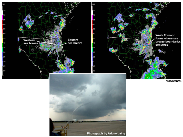
In Fig. 7.128, outflow from thunderstorms that developed along the western sea breeze and propagated east converged with the eastern sea breeze outflow. The tornado formed at the convergence zone between the two boundaries.
Supercells and Supercell Tornadoes
Supercell thunderstorms are rare in the tropics, occurring only under extraordinary conditions. However, because of their highly hazardous weather, their characteristics and conditions under which they may occur in the tropics need to be understood by tropical meteorologists. A supercell thunderstorm is an intense, relatively large thunderstorm (25-50 km scale) that produces severe weather and can last for several hours. Supercells are noted for generating the strongest tornadoes, large hail, strong winds, and heavy rain.
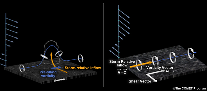
Supercells form in strongly sheared environments where the thunderstorm updraft tilts the horizontal vorticity upward to form a rotating updraft (Fig. 7.129). Environments conducive to supercell forming in the tropics occur where extratropical intrusions cause the meeting of dry, polar northerly and westerly winds with hot, moist tropical air masses, as occurs with cold fronts and subtropical cyclones. Strong shear and high CAPE are good indicators of the potential for supercells. Landfalling tropical cyclones can also generate sufficient shear to produce supercells.
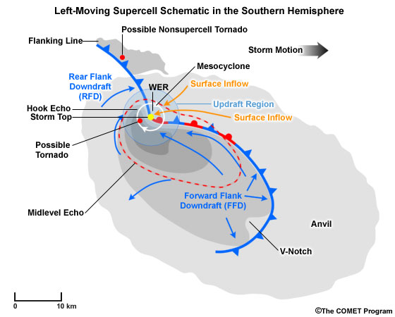
Unlike ordinary thunderstorms, supercells are characterized by a mesocyclone, a rotating updraft that is usually 2-10 km wide and about 3 km deep (Fig. 7.130). The mesocyclone creates the potential for tornado formation (white circle in Fig. 7.130) and leads to overshooting tops. A supercell generates a strong downdraft in its forward flank, where a shelf cloud spreads out and heavy precipitation usually falls. Tornadoes are also possible along the boundary created by the rear flank downdraft.
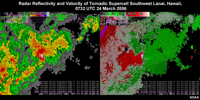
The mesocyclone is usually identified in radar base reflectivity images by a âhook echoâ (Fig. 7.131). The âhookâ surrounds a weak echo region where air is rising in the updraft. On base radar velocity images, the mesocyclone is identified as a rotational velocity couplet (Fig. 7.131).
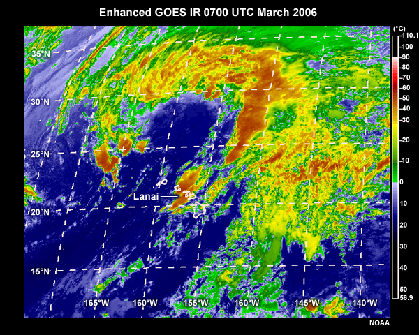
On enhanced satellite IR images, an âenhanced-Vâ or wedge-shaped cloud top feature is used to identify supercells producing imminent or current severe weather. Tornadoes and large hail usually occur near the apex of the wedge. Corresponding overshooting tops identify the same areas in high resolution visible images. Figure 7.132 shows supercell thunderstorms that produced large hail and a waterspout that moved on land in Lanai and Maui, Hawaii. The dark red areas correspond to the most intense thunderstorms; note the location of the apex of the wedge near Lanai. The vortex, seen in the radar images in Fig. 7.131, occurred about 30 minutes after the satellite image.
Tropical Cyclone Tornadoes
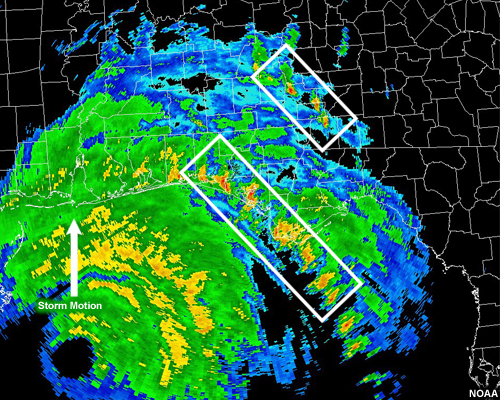
Most tornadoes spawned by tropical cyclones are weak, with intensities of F0-F2, and found in the right-forward (left-forward) quadrant of tropical cyclones in the Northern (Southern) Hemisphere (e.g., Fig. 7.133). Most are reported in the outer rainbands and commonly occur during the afternoon. The few inner region tornadoes are mostly F0 scale and have no preferential time of day.
When tropical cyclones make landfall the winds near the surface are slowed by the increase in friction and turbulence over land. This leads to lower-tropospheric vertical shear, which when tilted upwards, leads to the formation of mesocyclones. The shear over land is more than twice the shear over the ocean. From those mesocyclones tornadoes are formed and most occur when:
- The vertical wind shear from the surface to 850 hPa is greater than 20 m s-1
- The tropical cyclone is intense and/or intensifying just before landfall
Tornadoes from Extratropical Influences
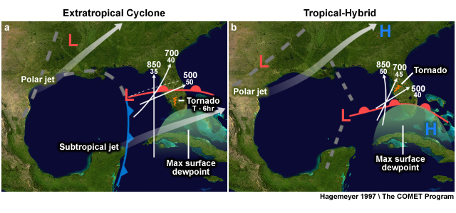
Most intense tornadoes that occur in the tropics are produced by squall lines or supercells associated with (i) extratropical cyclones or fronts and (ii) tropical-hybrid or subtropical environments (e.g., Fig. 7.134). Squall lines and supercells capable of producing tornadoes in the tropics are usually in the warm sector of extratropical cyclones, ahead of cold fronts that extend into the tropics (Fig. 7.134a). Large shear and convective instability occur when cold air from the extratropical westerlies meets warm tropical air masses flowing poleward. Such environments are conducive to the formation of severe thunderstorms, supercells, and tornadoes.
Much of our knowledge of tropical tornado environments comes from studies of tornadoes in Hawaii, the Florida peninsula, and India. According to the Florida 1950-1994 climatology,326 tornadoes from extratropical systems have environments with relatively weak instability and no capping inversion as is common in the US Great Plains. Instead, Florida extratropical tornado environments have a low-level moist layer beneath a very dry mid-tropospheric layer. The mid-troposphere dry layer comes from air subsiding in the subtropical upper-level high and acts as a source of substantial CAPE. Winds also increase with height to a maximum in the upper troposphere, where the subtropical jet promotes upper-level divergence. In Hawaii, which averages about one tornado per year, subtropical cyclones spawn thunderstorms that produce severe weather including tornadoes. Extratropical intrusions are also common in other tropical regions with reported tornadoes, such as India, Cuba, Puerto Rico, Southeast Asia, Brazil, and Australia.
Tornadoes form in a tropicalâhybrid environment when tropical or subtropical lows in the lower troposphere interact with midlatitude upper-level troughs (Fig. 7.134b). The thermodynamic profile of hybrid environments is similar to the extratropical cases. However, winds weaken with height from a maximum in the lower-tropospheric to an upper-tropospheric minimum. Compared with the prefrontal more baroclinic environment, the hybrid environments are more quasi-barotropic.
A
- Absolute angular momentum
- For the atmosphere, the absolute angular momentum, per unit mass of air, is the sum of the angular momentum relative to the earth and the angular momentum due to the rotation of the earth.
- Absolute vorticity
- See Vorticity.
- Absorber
- Anything that retains incident electromagnetic radiation due its physical composition.
- Absorption
- The process by which incident radiant energy is retained by a material due to the material's physical composition.
- Absorption band
- A portion of the electromagnetic spectrum where radiation is absorbed and emitted by atmospheric gases such as water vapor, carbon dioxide, and ozone.
- African easterly wave
- A trough or cyclonic curvature maximum in the trade-wind easterlies. The wave may reach maximum amplitude in the lower middle troposphere.
- Aggregation
- The clumping together of ice crystals after they collide.
- Anomaly
- The deviation of a quantity over a specified period from the normal value for the same region. For example, El Niño is identified by sea surface temperature anomalies.
- Atlantic Multidecadal Oscillation (AMO)
- A natural oscillation of the North Atlantic SST between warm and cool phases. The SST difference between these warm and cool phases is about 0.5°C and the period of the oscillation is roughly 20-40 years (the period is variable, but is a few decades long). Evidence suggests that the AMO has been active for at least the last 1,000 years.
- Attenuation
- Any process in which the intensity of radiation decreases due to scattering or absorption.
- Atmospheric Window
- A portion of the electromagnetic spectrum where radiation passes through the atmosphere without absorption by atmospheric gases such as water vapor, carbon dioxide, and ozone.
- Available potential energy (APE)
- The portion of the total potential energy available for adiabatic conversion to kinetic energy. The total potential energy is a combination of the APE and the potential energy representing the mass distribution needed to balance the mean atmospheric motions.
B
- Backscatter
- That portion of radiation scattered back toward the source.
- Baroclinic
- Dependence on the horizontal temperature contrast between warm and cold air masses., In a baroclinic atmosphere, the geostrophic wind varies with height in direction as well as speed and its shear is a function of the horizontal temperature gradient (the thermal wind equation).
- Barotropic
- The atmosphere has the same horizontal structure at all levels in the vertical. This is equivalent to the absence of horizontal temperature gradients.
- Barotropic-Baroclinic Instability
- Barotropic and baroclinic instability analyses are used to explain the growth of a small perturbation to the flow. A perturbation growing due to baroclinic instability draws its energy from the available potential energy (APE). A perturbation growing due to barotropic instability draws its energy from the kinetic energy of the background flow. A perturbation growing through both APE and mean kinetic energy conversion to kinetic energy of the growing system (intensifying the system) is developing through combined barotropic baroclinic instability.
- Best track
- As defined by the National Hurricane Center, it is a subjectively-smoothed representation of a tropical cyclone's location and intensity over its lifetime. The best track contains the cyclone's latitude, longitude, maximum sustained surface winds, and minimum sea-level pressure at 6-hourly intervals. Best track positions and intensities, which are based on a post-storm assessment of all available data, may differ from values contained in storm advisories. They also generally will not reflect the erratic motion implied by connecting individual center positions fixed during operations.
- Beta (β) effect
- Denotes how fluid motion is affected by spatial changes of the Coriolis parameter, for example, due to the earth's curvature. The term takes its name from the symbol β representing the meridional gradient of the Coriolis parameter at a fixed latitude. The asymmetric flows resulting from the interaction of the vortex with the changing Coriolis parameter is known as the β-gyres.
- Beta (β) plane
- An approximation of the Coriolis parameter in which f = f0 + βy, where β is a constant. The Coriolis parameter is assumed to vary linearly in the north-south direction. The term takes its name from the symbol β representing the meridional gradient of the Coriolis parameter at a fixed latitude.
- Blackbody
- An object that absorbs all incident radiation and emits the maximum amount of energy at all wavelengths.
- Blended precipitation estimate
- An estimate that is derived by combining low earth-orbiting microwave measurements, which have high resolution but low frequency, with the more frequently available geostationary IR.
- Bow echo
- An organized mesoscale convective system, so named because of its characteristic bow shape on radar reflectivity displays. Bow echoes are typically 20–200 km long and last for 3–6 hours. They are associated with severe weather, especially high, straight-line surface winds, which are the result of a strong rear-inflow jet descending to the surface.
- Brightness temperature
- The Planck temperature associated with the radiance for a given wavelength.
C
- Center
- Location of the vertical axis of a tropical cyclone, usually defined by the location of minimum wind or minimum pressure. The cyclone center position can vary with altitude.
- Cloud track winds
- Winds derived from tracking movement of cloud elements using IR and water vapor images from geostationary satellites.
- Conditional Instability of the Second Kind (CISK)
- A theory for tropical cyclone development that relates boundary layer moisture convergence (driven by Ekman pumping) to the potential for tropical cyclone intensification. As the storm intensifies, the moisture convergence must increase, providing a feedback to the system. As with WISHE, CISK relies on the presence of an incipient disturbance.
- Coordinated Universal Time (UTC)
- Same as Zulu (Z) and Greenwich Mean Time (GMT).
- Coriolis parameter, f
- A measure that is twice the local vertical component of the angular velocity of a spherical planet, 2Ω sinφ, where Ω is the angular speed of the planet and φ is the latitude.
- Cyclogenesis
- The formation of a cyclone.
- Cyclone
- An closed circulation of low pressure, rotating counter-clockwise in the Northern Hemisphere and clockwise in the SH.
- Cyclone Phase Space (CPS)
- A concise, three-parameter summary of the structure of a storm. It can be used to describe the structure of any synoptic or meso-synoptic cyclone.
D
- Deposition
- The process by which molecules are changed from the vapor phase directly to the solid phase, such as from water vapor to ice.
- Doppler Effect
- The apparent shift in the frequency and wavelength of a wave perceived by an observer moving relative to the source of the wave.
- Doppler radar
- Radar that uses the Doppler effect to detect radial velocity of targets based on the phase shift between the transmitted pulse and the received backscatter.
- Dvorak Technique
- a classification scheme for estimating the intensity of TCs from enhanced IR and visible satellite imagery. It is the primary method of estimating intensity everywhere, except the North Atlantic and North Pacific where aircraft reconnaissance is routine.
E
- Eddy angular momentum flux (EAMF)
- Flux (net transport) of angular momentum into a circle centered on the storm. If EAMF is positive, the flow inside the circle will become more cyclonic; negative EAMF render the system less cyclonic (more anticyclonic). See Box 8-6 for a definition and discussion of angular momentum in tropical cyclones.
- Ekman layer
- Thin horizontal layer of water at top of the ocean that is affected by wind. That layer has a force balance between pressure gradient force, Coriolis force and frictional drag.
- Ekman layer instability
- A shearing instability in a boundary layer where the mean flow results from a balance between the forces of friction, pressure gradient, and Coriolis. The instability appears as vortex rolls in the form of a spiral band.
- Ekman pumping
- The force balance determining the vector wind is modified by friction at the Earth's surface. The addition of friction changes the force balance to slow the winds and change their direction: winds now flow into a low and out of a high pressure system. Winds flowing into a low because of friction are forced upwards and out of the boundary layer. This process is known as Ekman pumping.
- El Niño-Southern Oscillation (ENSO)
- An oscillation of the ocean-atmosphere system in the tropical Pacific which affects global weather and climate. El Niño, the warm phase of ENSO, is a quasi-periodic (2-7 years) warming of ocean surface waters in the equatorial and eastern tropical Pacific and an eastward shift in convection from the western Pacific climatological maximum. Changes occur in the tropical trade easterlies, vertical wind shear, and ocean height. Cool ocean temperature anomalies are observed in the tropical western Pacific extending eastward into the subtropics of both hemispheres. "La Niña" refers to the less intense, anomalous cool phase of ENSO. The Southern Oscillation refers to the atmospheric pressure difference between Darwin and Tahiti that is correlated with El Niño.
- Electromagnetic (EM)
- Energy carried by electric and magnetic waves.
- Emission
- The process by which a material generates electromagnetic radiation due to its temperature and composition.
- Emissivity
- The emitting efficiency of an object compared to an ideal emitter (or blackbody). A blackbody has an emissivity of one.
- Emitter
- Anything that radiates measurable electromagnetic radiation.
- Empirical Orthogonal Function (EOF)
- See Principal Component Analysis.
- Energy
- The capacity to do work or transfer heat. Measured in SI units as Joules.
- Entrainment
- The integration of unsaturated environmental air into the turbulent cloud-scale circulation. The antonym of entrainment is detrainment.
- Explosive Deepening
- A decrease in the minimum sea-level pressure of a tropical cyclone of 2.5 hPa hr-1 for at least 12 hours or 5 hPa hr-1 for at least six hours.
- Extratropical
- A term used to indicate that a cyclone has lost its “tropical” characteristics. The term implies both poleward displacement of the cyclone and the conversion of the cyclone’s primary energy source from the release of latent heat of condensation to baroclinic processes.
It is important to note that cyclones can become extratropical and still retain winds of hurricane or tropical storm force. Given that these dangerous winds can persist after the cyclone is classified as extratropical, the Canadian Hurricane Centre (for example) follows them as “Former hurricane XXX.”
- Extratropical Transition (ET)
- The evolution of a poleward-moving initially tropical cyclone resulting in an extratropical cyclone. In the process of this evolution the energy source of the storm shifts from latent heat release to baroclinic development.
- Eye (of tropical cyclone)
- The approximately circular area of light winds at the center of a tropical cyclone. It is surrounded entirely or partially by clouds in the eyewall.
- Eyewall / Wall Cloud
- The full or partial ring of thunderstorms that surround the eye of a tropical cyclone. The strongest sustained winds in a tropical cyclone occur in the eyewall.
F
- Field of View (FOV)
- Generally associated with the ground resolution from the detector standard viewing location, field of view is the solid angle through which a detector observes radiation.
- Fraction of Photosynthetically Active Radiation (FPAR)
- An index that measures how much sunlight the leaves are absorbing.
- Frequency
- The number of recurrences of a periodic phenomenon per unit time. The frequency, v, of electromagnetic energy is usually specified in Hertz (Hz), which represents one cycle per second.
- Fujiwhara Effect
- The mutual advection of two or more nearby tropical cyclones about each other. This results in cyclonic rotation of the storms about each other.
G
- Gale Force Wind
- A sustained surface wind in the range 17 m s-1 (39 mph, 63 km hr‑1 or 34 knot) to 24 m s-1 (54 mph, 87 km hr‑1 or 47 knot) inclusive, and not directly associated with a tropical cyclone.
- Geostationary or Geosynchronous orbit
- An orbit whose rotation period equals that of the Earth. The altitude of a geostationary orbit is approximately 35,800 km. Its orbit keeps it above a single point on the equator.
- GOES
- Geostationary Operational Environmental Satellite (operated by NOAA).
- GOES Precipitation Index
- An estimate of precipitation that uses 235K as the IR temperature with the best correlation to average precipitation for areas spanning 50-250 km over 3-24 hours.
- GPS
- Global Positioning System, a network of defense satellites established in 1993. Each satellite broadcasts a digital radio signal that includes its own position and the time, accurate to one billionth of a second. GPS receivers use the signals to calculate their position to with a few hundred feet.
- GPS radio occultation
- The technique by which satellite receivers intercept signals from GPS and infer the deviations in the signal's path caused by temperature and moisture gradients.
- Gravity waves
- Oscillations usually of high frequency and short horizontal scale, relative to synoptic- scale motions, which arise in a stably stratified fluid when parcels are displaced vertically. Gravity is the restoring force.
- Greenwich Mean Time (GMT)
- Mean solar time of the meridian at Greenwich, England, used as the basis for standard time throughout most of the world. Also referred to as Zulu (Z) and Coordinated Universal Time (UTC).
H
- Hadley Cells
- Circulation cells in which air rises in the ITCZ, sinks into the subtropical highs, and returns to the equatorial low along the trade winds. George Hadley proposed a model (1735) of the global atmospheric circulation with rising motion at the equator, where there is surplus heating, and sinking motion at the poles, where there is net cooling. Hadley's model did not account for the Coriolis effect, which leads to average westerly motion in the mid-latitudes. The Hadley model does explain the circulation within 30 degrees of the equator.
- Horizontal Convective Rolls
- Lines of overturning motion with axes parallel to the local surface. These rolls result from a convective instability (high density over low density – often corresponding to cool air over warm) and can mix strong winds from above down towards the surface.
- Hurricane
- A tropical cyclone in which the maximum sustained surface wind (using the local time averaging convention) is at least 33 m s-1 (74 mph, 119 km hr-1 or 64 knot). The term "hurricane" is used for in the Northern Atlantic and Northeast Pacific; "tropical cyclone" east of the International Dateline to the Greenwich Meridian; and "typhoon" in the Pacific north of the Equator and west of the International Dateline.
I
- Inertial period
- The time taken to complete one rotation. In the tropical cyclone this is calculated by dividing the circumference at the radius of interest (commonly, the radius of maximum winds) by the wind speed at that radius.
- Infrared (IR)
- Electromagnetic energy within the wavelength interval generally defined from 0.7 to 100 microns.
- Irradiance
- The energy per unit time incident upon a unit area of a given surface, measured in SI units as Wattsm-2.
- Insolation
- The incoming solar radiation that reaches the earth and its atmosphere.
- Intensity
- The peak sustained surface wind in the region immediately surrounding the storm center, or the minimum central pressure measured in the eye.
- Intertropical Convergence Zone (ITCZ)
- The zone where the northeast and southeast trade winds converge. It is marked by low pressure, rising motion, and thunderstorms, which occur with strong surface heating. Its latitudinal position shifts in response to the solar maximum and heating response of the surface. It is recognized in satellite images as a band of thunderstorms across the tropics. It is often, but not always, co-located with the zone of low pressure known as the "Equatorial Trough".
- Intraseasonal
- Varying on time scales shorter than one season.
J
- Joule
- SI unit of energy equal to 0.2389 calories.
K
- Kelvin waves
- At the equator, eastward propagating waves with negligible meridional velocity component and Gaussian latitudinal structure in zonal velocity, geopotential, and temperature, symmetric about the equator.
L
- Landfall
- The intersection of the surface center of a tropical cyclone with a coastline. Because the strongest winds in a tropical cyclone are not located precisely at the center, it is possible for the strongest winds to be experienced over land even if landfall does not occur.
- Leaf Area Index (LAI)
- The ratio of green leaf area to the total surface area occupied by vegetation.
- Longwave (LW)
- Electromagnetic energy lying in the wavelength interval generally defined from 4.0 microns to an indefinite upper limit.
- Low earth orbit (LEO)
- An orbit that is located at an altitude generally between 200 and 1000 km.
- Low earth orbit satellite
- A satellite that has a low earth orbit. Most have paths crossing the poles and can provide synchronous observations (e.g., the NOAA series or Defense Meteorological Satellite Program systems). The TRMM is an LEO satellite that orbits between ±35º latitude.
M
- Madden-Julian Oscillation (MJO)
- Tropical rainfall exhibits strong variability on time scales shorter than the seasonal. These fluctuations in tropical rainfall often undergo a 30-60 day cycle that is referred to as the Madden-Julian Oscillation or intraseasonal oscillation. The MJO is a naturally occurring component of the Earth's coupled ocean-atmosphere system that significantly affects the atmospheric circulation throughout the global tropics and subtropics.
- Maritime Continent
- The region of Southeast Asia that comprises many islands, peninsulas, and shallow seas (including countries such as Indonesia, Malaysia, Papua New Guinea, and the Phillipines and covers approximately 12°S to 8°N, 95°E to 150°E).
- Meridional
- North-south, crossing latitudes; by convention the meridional wind from the south is positive.
- Mesoscale
- Spatial scale of 100-1000 km and temporal scale of hours to a day; between synoptic and convective scale. Tropical clouds are most often organized into mesoscale systems.
- Mesoscale convective complex (MCC)
- A large, quasi-circular mesoscale convective system that produces heavy rainfall and severe weather. In some MCCs, a mid-tropospheric vortex forms and remains after the deep convection has dissipated.
- Mixed Rossby-Gravity (MRG) Wave
- A divergent Rossby wave, resulting from conservation of potential vorticity and buoyancy forcing. These waves propagated westward along the equator. Meridional velocity is symmetric about the equator. Zonal wind, temperature, and geopotential area antisymmetric about the equator.
- Monochromatic
- Of or pertaining to a single wavelength, or in practice, perhaps a very narrow spectral interval.
- Monsoon
- A term whose roots are from the Arabic for "season", it is a seasonal wind reversal. The monsoon has inflow to a surface heat low and an offshore flow from high pressure during the winter when the land cools relative to the ocean. The Indian monsoon is the most prominent but it has been recognized that that monsoon region extends from Southeast Asia to West Africa. The summer monsoon is a vital source of moisture; its arrival, duration, and amount of precipitation modulates the economies of these regions.
- Monsoon Gyre
- A closed, symmetric circulation at 850 hPa with horizontal extent of 25° latitude that persists for at least two weeks. The circulation is accompanied by abundant convective precipitation around the south-southeast rim of the gyre.
- Monsoon Region
- Refers to the combination of features including a monsoon trough, confluence zone, and the ITCZ.
N
- Nadir
- The satellite viewing angle directly downward (viewing zenith angle = 0 degrees). Also used to refer to the sub-satellite point location.
- Navier Stokes equations
- The set of three equations describing the time evolution of the atmospheric motions. They are often referred to as "the equations of motion" or "the momentum equations".
0
- Ocean conveyor belt
- The name given to summarize the pattern of global ocean currents. The surface ocean currents generally transport warm salty water polewards, out of the tropics. The water cools as it moves polewards, becoming increasingly dense (remember that salty water is more dense than fresh water). This water sinks in the North Atlantic and also in the Southern Ocean near Antarctica. The deep water currents transport the water around the globe until it rises to the surface again, once more part of the surface ocean currents.
- Opaque
- A physical description of a material which attenuates electromagnetic radiation.
- Optical depth
- A measure of the cumulative attenuation of a beam of radiation as a result of its travel through the atmosphere.
P
- Pacific Decadal Oscillation (PDO)
- The PDO is a basin-scale pattern of Pacific climate variability; PDO climate anomalies are most visible in the North Pacific and North American regions, with secondary features in the tropics. The phases of the PDO persist for 20-to-30 years. Causes for the PDO have not yet been explained.
- Planck's Law
- An expression for the variation of monochromatic radiance as a function of wavelength for a blackbody at a given temperature.
- Planetary Boundary Layer (PBL)
- The layer of the atmosphere that extends upward from the surface to heights of 100 to 3000 m. The boundary layer is directly influenced by surface forcing such as friction, heating, and evapotranspiration.
- Polar orbit
- An orbit whose path crosses the polar regions. This type of orbit is located at an altitude generally between 200 and 1000 km, and can provide sun-synchronous observations.
- Polar Orbiting Environmental Satellite (POES)
- A satellite which has a polar orbit, such as the NOAA series or Defense Meteorological Satellite Program systems.
- Potential evapotranspiration
- A measure of the maximum possible water loss from an area under a specified set of weather conditions.
- Potential Intensity (PI)
- The largest possible intensity (maximum wind, minimum pressure) expected to be possible for a particular tropical cyclone.
- Potential vorticity
- A scalar measure of the balance between the vorticity and the thermal structure of the atmosphere.
- Principal component analysis
- A mathematical technique for identifying patterns in data by reducing multidimensional data to a smaller number of dimensions. A number of variables that are (possibly) correlated are transformed into a new coordinate system. The transformation identifies the components that account for variability in the data. The first principal component often accounts for the most of variability in the data. Also known as Empirical Orthogonal Function (EOF) analysis.
Q
- Quasi-Biennial Oscillation (QBO)
- An oscillation in the lower stratospheric zonal winds averaged around the equator. It is typically diagnosed from the zonal winds between 30-70 hPa (although it is evident as high as 10 hPa). The QBO has a varying from about 24 to 30 months. The zonal winds change by about 40 m s-1 between the maximum easterly and maximum westerly phase.
R
- Radar (Radio Detection And Range)
- An instrument that detects objects remotely by transmitting high-frequency pulses to the atmosphere and measuring the "backscatter" or echoed pulses from that object. Weather radar transmits microwave (mm-cm) pulses; the returned signal is interpreted to determine where it is precipitating.
- Radiance
- A measure of radiant intensity produced by a material in a given direction and per unit wavelength interval, measured in Watts/m 2 /steradian/micron. Monochromatic radiance is the most fundamental unit measured by satellite instruments.
- Radiation
- Energy transferred by electromagnetic waves.
- Radius of Maximum Winds
- The distance from the center of a tropical cyclone to the location of the cyclone's maximum winds. In well-developed systems, the radius of maximum winds is generally found at the inner edge of the eyewall.
- Rapid Deepening
- A decrease in the minimum sea-level pressure of a tropical cyclone of 1.75 hPa hr-1 or 42 hPa for 24 hours.
- Recurvature
- The poleward motion of a tropical cyclone taking it from the mean tropical easterlies to the midlatitudes westerlies. This change in the advection of the storm results in curvature in the storm track.
- Reflection
- The process by which incident radiation is scattered in the backward direction (backscattered).
- Reflectivity
- The fraction of incident radiation reflected by a material.
- Relative vorticity
- See Vorticity.
- Remnant Low
- Used for systems no longer having the sufficient convective organization required of a tropical cyclone (e.g., the swirls of stratocumulus in the eastern North Pacific).
- Retrieval
- The process or end result of a process where physical quantities such as water vapor, temperature, and/or pressure are extracted from measurements of total upwelling radiance to space; here involving the GOES sounder.
- Reyleigh Instability
- Instability of a horizontal fluid layer heated from below or cooled from above. The onset of convection due to this thermal instability was first documented by Lord Rayleigh and Henri Bérnard (although the latter discovery was an instability due to surface tension differences that occur when a fluid is unevenly heated). Mesoscale cellular convection in the atmospheric boundary layer appears similar to Rayleigh-Bérnard convection.
- Riming
- The formation of ice by the rapid freezing of supercooled water drops as they impinge upon an object such as an ice crystal or aeroplane wing.
- Rossby Radius of Deformation
- The Rossby radius is the critical scale at which rotation becomes as important as buoyancy, which allows an initial disturbance to be sustained. It is a function of the absolute vorticity, stability, and depth of the disturbance. When a disturbance is wider than LR, it will persist; systems that are smaller than LR will dissipate.
- Rossby Wave
- A planetary wave, resulting from conservation of potential vorticity. Gradients of potential vorticity provide a restoring mechanism to allow propagation of the waves. This text focuses on Rossby waves centered on the equator equatorial (n=1) Rossby waves.
S
- Saffir-Simpson scale
- A scale that links the observed damage and the effects of wind, pressure and storm surge that could lead to such damage. Initial wind damage scale was defined by Herbert Saffir and later expanded by Robert Simpson to include storm surge.
- Scattering
- The process by which a material interacts with and redirects incident radiation (in any given direction).
- Scatterometer
- A radar that infers near-surface wind velocity by sending pulses of microwave energy to the ocean surface and measuring the backscatter from small-scale waves. Scatterometry wind retrievals can be ambiguous during rain, since rain creates additional backscatter and attenuates the radar beam.
- Shortwave (SW)
- Electromagnetic radiation generally defined as having a wavelength shorter than 4.0 microns.
- Size
- The mean radius of a tropical cyclone enclose by winds of at least 17 m s-1. Size may also be defined as the outer closed isobar of the surface pressure.
- Solar declination angle
- The angle between the rays of the Sun and the equatorial plane of the Earth. It is zero during an equinox and 23.5° during a solstice.
- Southern Oscillation Index (SOI)
- The normalized difference in sea level pressure between Darwin, Australia and Tahiti, French Polynesia.
- Specific humidity
- The mass of water vapor per unit mass of air (including water vapor), usually denoted by q and measured in units of grams per kilograms.
- Spectral
- A descriptor for radiometric quantities or measurements which have a limited wavelength range.
- Split window
- A pair of regions of the electromagnetic spectrum which are closely located in wavelength, but have slightly different attenuation characteristics. Used to denote the 11- and 12-micron regions in which greater water vapor attenuation at 12 microns causes slightly different brightness temperatures.
- Stefan-Boltzmann Law
- The energy emitted per unit area (from all wavelengths and represented by the area under the blackbody curve) is proportional to the 4 th power of the absolute temperature
- Steradian
- The unit of measure of solid angles, equal to the angle subtended at the center of a sphere.
- Storm Surge
- An abnormal rise in sea level accompanying a tropical cyclone or other intense storm, and whose height is the difference between the observed level of the sea surface and the level that would have occurred in the absence of the cyclone. Storm surge is usually estimated by subtracting the normal or astronomic high tide from the observed storm tide.
- Storm Tide
- The actual level of sea water resulting from the astronomic tide combined with the storm surge.
- Subtropical Cyclone
- A non-frontal low pressure system that has characteristics of both tropical and extratropical cyclones.
The most common type is an upper-level cold low with circulation extending to the surface layer and maximum sustained winds generally occurring at a radius of about 100 miles or more from the center. In comparison to tropical cyclones, such systems have a relatively broad zone of maximum winds that is located farther from the center, and typically have a less symmetric wind field and distribution of convection.
A second type of subtropical cyclone is a mesoscale low originating in or near a frontolyzing (dying frontal) zone of horizontal wind shear, with radius of maximum sustained winds generally less than about 50 km (30 miles). The entire circulation may initially have a diameter less than 160 km (100 miles). These generally short-lived systems may be either cold core or warm core.
- Subtropical Depression
- A subtropical cyclone in which the maximum sustained surface wind speed does not exceed 17 m s-1 (39 mph, 63 km hr‑1 or 34 knot).
- Subtropical Storm
- A subtropical cyclone in which the maximum sustained surface wind speed is at least 17 m s-1 (39 mph, 63 km hr‑1 or 34 knot).
- Synthetic Aperture Radar (SAR)
- Works like other radars except that it has very fine resolution in the azimuthal direction. It synthesizes the fine resolution normally achieved with a large antenna by combining signals from an object along a radar flight track and processing the signals as if obtained simultaneously from a single large antenna. The distance over which the signals are collected is known as the synthetic aperture.
T
- Trade Winds
- Prevailing easterly winds flowing from the subtropical highs that affect equatorial and subtropical regions. Trade winds are mostly east to northeasterly in the Northern Hemisphere and east to southeasterly in the Southern Hemisphere. During the monsoon, easterly trades are replaced by mostly westerly winds.
- Transmission
- The process by which incident radiation propagates forward through a material.
- Transpiration
- The process by which water vapor enters the atmosphere through the stomata in the leaves of plants.
- Thermocline
- The inversion layer separating the near-surface warm waters from the colder, deeper layers of oceans and lakes. It is about 1km deep and is thermally stratified. In the ocean, it also separates the fresher waters near the surface from the saltier waters below.
- Total Precipitable Water (TPW)
- The depth of water in a vertical column of unit cross-sectional area if the total atmospheric water vapor contained in that column, extending between the surface and the "top" of the atmosphere, completely condensed.
- Tropical Cyclone
- A warm-core non-frontal synoptic-scale cyclone, originating over tropical or subtropical waters, with organized deep convection and a closed surface wind circulation about a well-defined center. Once formed, a tropical cyclone is maintained by the extraction of heat energy from the ocean at high temperatures and heat export at the low temperatures of the upper troposphere. In this they differ from extratropical cyclones, which derive their energy from horizontal temperature contrasts in the atmosphere (baroclinic effects). Also see Hurricane.
- Tropical Cyclone Season
- The portion of the year having a relatively high incidence of tropical cyclones. Also known as "Hurricane Season" or "Typhoon Season".
- Tropical Depression
- A tropical cyclone in which the maximum sustained surface wind speed is not more than 17 ms-1 (39 mph, 63 km hr‑1 or 34 knot).
- Tropical Disturbance
- A discrete tropical weather system of apparently organized convection – generally 185 to 550 km (100-300 n mi) in diameter – originating in the tropics or subtropics, having a nonfrontal migratory character, and maintaining its identity for 24 hours or more. It may or may not be associated with a detectable perturbation of the wind field.
- Tropical Storm
- A tropical cyclone in which the maximum sustained surface wind speed ranges from 17 ms-1 (39 mph, 63 km hr‑1 or 34 knot) to 33 ms-1 (74 mph, 119 km hr-1, 64 knot).
- Typhoon
- See Tropical Cyclone and Hurricane.
U
- Ultraviolet (UV)
- Electromagnetic radiation of shorter wavelength than visible radiation but longer than x-rays (approximately 0.03 to 0.4 microns)
V
- Virtual Potential Temperature
- In a system of moist air the potential temperature of dry air having the same density and pressure as the moist air.
- Visible
- The region of the electromagnetic spectrum which is detectable to the human eye (approximately 0.4 to 0.7 microns).
- Vorticity
- The local rotation of the flow, calculated as the the curl (cross product) of the vector wind. Vorticity has units of inverse seconds (s-1).
“Relative vorticity” is the vorticity calculated for the observed winds. It is called “relative” since the winds are the flow relative to the Earth’s rotation.
The vertical component of the vorticity vector is most often used since it is much larger than the other vorticity components. This is because the horizontal winds in tropical cyclones are much greater than the vertical wind component.
“Absolute vorticity” is the vorticity calculated for the total motion of the atmosphere the combination of the observed winds and the Earth’s rotation.
W
- Walker Circulation
- The east-west circulation cells that form along the equator in response to differential surface heating.
- Warning
- A warning that sustained winds exceeding the threshold for either tropical storm or tropical cyclone and associated with such a storm are expected in a specified coastal area in 24 hours or less.
- Watch
- An announcement for specific coastal areas that either tropical storm or tropical cyclone conditions are possible within 36 hours.
- Wavelength
- The distance a wave will travel in the time required to generate 1 cycle, denoted by λ. A length measured from the midpoint of a crest (or trough) to the midpoint of the next crest (or trough).
- Wavenumber
- The reciprocal of the wavelength, denoted by κ.
- Water Vapor Channel (or water vapor IR channel)
- A spectral band in which the radiance is attenuated by water vapor. This usually refers to the 6.7 micron channel in this module.
- Weighting function
- A mathematical expression representing the relative radiance contribution provided from a given level of the atmosphere (usually a function of atmospheric pressure).
- Wind-Induced Surface Heat Exchange (WISHE)
- A tropical cyclone development theory based on a conceptual model of a tropical cyclone as an atmospheric Carnot engine. Consistent with its Carnot engine roots, WISHE relates (i) fluxes of heat and moisture from the ocean surface and (ii) the temperature of the tropical cyclone outflow layer to the potential for continued storm development. The fluxes increase with surface wind speed providing a feedback to the system. As with CISK, WISHE relies on the presence of an incipient disturbance.
- Wind profiler
- Vertically pointing radar which operates on the same principle as horizontally-scanning Doppler radar; provides best measurements of vertical air motion inside convective storms
- Wien's Displacement Law
- The wavelength of maximum blackbody emission is inversely proportional to its absolute temperature.
X
Y
Z
- Zonal
- East-west, crossing longitudes; by convention, the zonal wind from the west is positive.
- Zulu (Z)
- Used to represent the same clocktime at GMT and UTC. See Greenwich Mean Time (GMT), or Coordinated Universal Time (UTC)