Chapter 7: Synoptic and Mesoscale Systems

7.2 Mesoscale Weather Systems »
7.2.2 Mesoscale Convective Systems »
7.2.2.3 Environments of Tropical MCSs

Vertical Wind Shear

While the main ingredient for cumulus convection is moist air that is warmer than its environment (Section 5.2.2.2Section 5.2.2.2), the vertical wind shear is critical for determining the organizational mode and longevity of MCSs.234,254,255 The CAPE is key to their updraft strength and depth.256

Tropical versus Midlatitude Shear

In general, tropical MCSs develop in environments with weaker cold pools and weaker horizontal wind shear than the midlatitudes. Both tropical and midlatitude MCSs have weak or straight-line mid-level shear profile with most of the vertical wind shear found in the low-levels (often generated by a low-level jet). The 950 and 650 hPa shear in non-squall tropical clusters (the least intense MCSs) is less than 5 m s-1 while tropical squall lines with bow echoes (which have the highest likelihood of strong, straight-line surface winds) have mean shear of about 13 m s-1. By comparison, 10 m s-1 is the upper threshold for weak shear environments in midlatitude MCSs.

 Four main categories of convective structures for given vertical shears in the lower troposphere (1000–800 hPa) and at middle levels (800–400 hPa) based on the Coupled Ocean Atmosphere Response Experiment (COARE) observations, but modified to include results from the South China Sea Monsoon Experiment (SCSMEX)
Fig. 7.96. Four main categories of convective structures for given vertical shears in the lower troposphere (1000–800 hPa) and at middle levels (800–400 hPa) based on the Coupled Ocean Atmosphere Response Experiment (COARE) observations, but modified to include results from the South China Sea Monsoon Experiment (SCSMEX). Lengths of the schematic convective bands are 100–300 km; line segments in upper-left panel are up to 50-km length. Cutoff between "strong" and "weak" shear for lower layer (1000–800 hPa) is 4 m s-1 and for middle layer (800–400 hPa) is 5 m s-1. Arrows marked L and M are shear vectors for lower and middle layers, respectively. (Johnson et al. 2005, adapted from LeMone et al 1998)

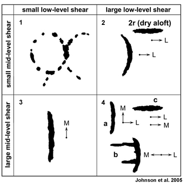
Figure 7.96 shows how shear organizes tropical convective structure and orientation, with lines generally perpendicular or parallel to the shear in the low and mid-troposphere.257,258 With weakly sheared environment, convection developed along outflow boundaries (Panel 1), With strong low-level shear and weak midlevel shear, the main convective band is perpendicular to the low-level shear (Panel 2 in Fig. 7.96). Without strong low-level shear, lines form parallel to the low-level shear (Panel 3), while more complex structures occur with strong low and mid-level shear (Panel 4).

Updrafts in MCSs

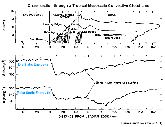
In MCSs with a trailing stratiform region, updraft speeds range from 5-17 m s-1 in the convective region and 35-45 cm s-1 in the stratiform region. Mesoscale downdrafts, in the stratiform region, of the typical tropical MCS are in the 5-25 cm s-1 range. How do these MCS features form and evolve?

1) The traditional view is of updrafts created because of static instability, also known as buoyant or gravitational instability. Parcels of warm, moist (with high equivalent potential temperature θe) air from the boundary layer, accelerate upward after being forced above the local level of free convectionlevel of free convection, entrain varying amounts of environmental air via in-cloud turbulence as they rise, then decelerate and eventually stop and spread out laterally at or near the equilibrium level, where they are neutrally buoyant (Section 5.2.2.2Section 5.2.2.2). However, the idea undiluted updrafts in “hot towers” over the oceanic equatorial trough has been challenged by recent field and satellite observations.259 Such undiluted updrafts are relatively rare over tropical oceans; rather, freezing is an important source of additional buoyancy.25

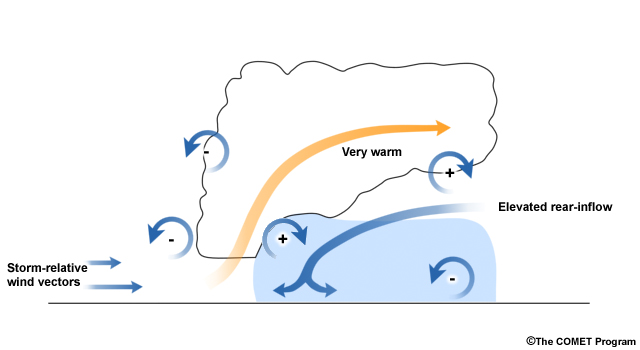
2) The upward air motion that maintains a mature MCS occurs in the form of a deep slantwise ascending layer of air.260 In this view, θe is conserved along streamlines.261,262 If the large-scale environment is unstably stratified and sheared, air must flow through the storm along a unique set of streamlines. For a typical environment of strong low level shear, the updraft would then be of a layer ascending on a slantwise path through the storm.

3) Another theory is that of gravity wave responses to the heating by the MCS.263,264 Simulations of MCSs found that once convective cells become clustered into an organized mesoscale group, this structure serves as a quasi-steady heat source. A layer of 3- to -6 km inflow is then drawn up through the system as a gravity wave response to the heating. The layer of inflow air enters the convective region, rising and exiting as the middle to upper level front-to-rear flow.

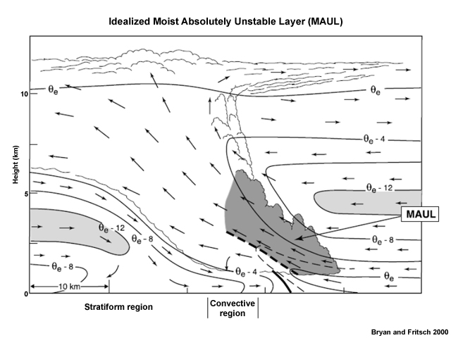
4) Moist absolutely unstable layer (MAUL) layer lifting operates when the layer is potentially unstable265 (Fig. 7.97). Radar observations of MCSs during TOGA-COARE showed sloping updrafts with finite layers of air, 0.5-4.5 km depth, rising over a downdraft cold pool.266

 Idealized cross section through slab convective overturning. Flow vectors are system-relative, scalloped lines indicate cloud boundaries, solid lines are θe contours every 4 K (thin dashed line is an intermediate contour and heavy dashed line marks axis of highest values), heavy solid line indicates outflow boundary or frontal zone, light shading highlights midlevel layer of low θe air, and dark shading depicts the MAUL.
Fig. 7.97. Idealized cross section through slab convective overturning. Flow vectors are system-relative, scalloped lines indicate cloud boundaries, solid lines are θe contours every 4 K (thin dashed line is an intermediate contour and heavy dashed line marks axis of highest values), heavy solid line indicates outflow boundary or frontal zone, light shading highlights midlevel layer of low θe air, and dark shading depicts the MAUL.265

Thermodynamic evolution

 Soundings taken before and after a squall line in the West Pacific
Fig. 7.98. Soundings taken before and after a squall line in the West Pacific.

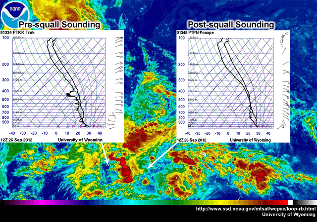
The pre-squall environment is marked by a moist boundary layer, moderate-high CAPE, low level of free convection (Fig. 7.98). As the squall line passes, the following features are observed: a pre-squall mesolow (due to subsidence warming in the mid-to upper troposphere), a mesohigh (due to heavy precipitation and convective-scale downdrafts), and a wake low (due to subsidence warming and as a surface expression of the descending rear inflow jet) (Fig. 5.19). Post squall environments are characterized by subsidence, adiabatic compression, which warms and dries the lower troposphere, as indicated by an onion-shaped sounding231 (Fig. 7.98). A squall line example is shown but the process is similar for other MCSs.

Squall Line MCS environments

Tropical squall line development is aided by strong low-level wind shear (for GATE squall lines, the critical threshold was 13 m s-1 in the 950-650 hPa layer, mostly perpendicular to the leading line). Squall lines, in turn, transport momentum upgradient, increasing the low-level vertical wind shear.

The organizational mode of the squall line, e.g., its slope and size of the stratiform region, is dependent on the relative strengths of the downdraft-generated cold pool and the vertical wind shear.254,255,267 The strength of the cold pool influences its propagation speed. The convectively-generated cold pool acts as a gravity current because it is denser than its environment. New convection is formed by uplift along the boundary of the cold pool. Its speed is given by:

eqn         (4)

where h is the height of the spreading cold pool, g is the gravitational constant, eqnis the environmental virtual potential temperature and eqn is the perturbation virtual potential temperature of the cold pool. Gust fronts can precede storm cells of a few tens of km (20 to 40 km). Normally, the density current head has a rotor circulation. The typical depth of the cold pool is ~ 1 km. It is often thinner over the ocean (200-300 m) than over continents (up to 3 km). With passage of the cold pool, winds intensify and rotate, temperature drops 2 to 10° C, and pressure jumps 1 to 2 hPa. The moisture content also falls.

 Conceptual depiction of the balance between the cold-pool horizontal vorticity and the environmental shear for a mature, long-lived, tropical MCS
Fig. 7.99. Conceptual depiction of the balance between the cold-pool horizontal vorticity and the environmental shear for a mature, long-lived, tropical MCS.

When the shear is stronger than the cold pool, the updraft is tilted away from its source of warm, moist air and the tops of the cells are “shorn off”. When vertical shear is weak, the cold pool moves out from the original updraft, cutting off the supply of warm, moist air (the high θe air). When the shear vorticity is balanced by the cold pool vorticity, the updraft remains upright, the cold pool triggers lifting, and the convective system is long-lived254,255 (Fig. 7.99).

 Conceptual model of midlatitude linear MCSs (squall line) archetypes, their structure and corresponding vertical shear and evolution from initiation to maturity
Fig. 7.100. Conceptual model of midlatitude linear MCSs (squall line) archetypes, their structure and corresponding vertical shear and evolution from initiation to maturity.207

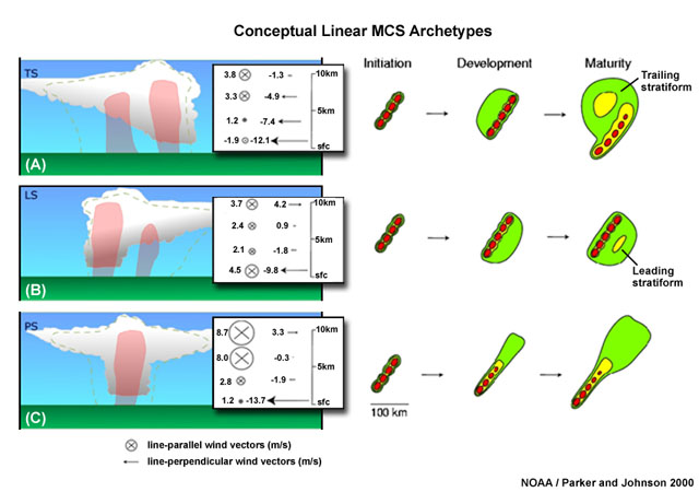
How the stratiform region evolves reflects the orientation of the vertical shear vector relative to the squall line motion (Fig. 7.100). The commonly observed trailing stratiform type develops where dominant shear is perpendicular to the line. The parallel stratiform region has more line parallel shear in the upper-levels and the leading stratiform has weaker low-level shear than the other two types (Fig. 7.100). It is not clear how the archetypes can be applied generally in the tropics given the generally weaker shear compared with the midlatitudes.

At the large-scale, the dominant forcing of squall clusters in the western Pacific and tropical Atlantic is convergence in the ITCZ. Systems observed during the Global Atmospheric Research Program (GARP) Atlantic Tropical Experiment (GATE) formed several hours after large-scale convergence was established and moisture flux increased in the low-middle troposphere.

Squall clusters also occur with easterly waves, which are noted for having low-level convergence, divergence above 200 hPa, and non-divergence in between. They normally form ahead of the easterly wave trough, move at about twice the speed of the wave, and tend to die just behind the ridge. Amazon squall lines have added mesoscale forcing from the sea breeze front.48,268

Bow echo environments

Bow echoes most commonly occur in an environment with strong deep layer shear in combination with high CAPE, steep midlevel lapse rates, and a strong cold pool. Bow echoes sometimes develop within pre-frontal squall lines and tropical cyclone rainbands. For example, squall lines and bow echoes in the developing Tropical Storm Nicole (2010) produced tornadoes, damaging strong surface winds, and heavy rainfall (COMET module, “Severe Weather and Flooding in Jamaica”, http://www.meted.ucar.edu/radar/tropical_cases/navmenu.php?tab=2&page=1.0.0).

MCC environments

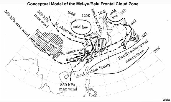
Most MCCs initiate within prominent baroclinic zones (such as the monsoon trough, stationary fronts, and the Mei-Yu/Baiu front), which have locally large values of lower-tropospheric vertical wind shear and CAPE. Development is favored when a convectively-generated surface cold pool combined with substantial low-level vertical wind shear leads to a deep layer of slantwise ascent and a large stratiform cloud region. Most of the wind shear in MCC environments is found in the low-levels (often generated by a low-level jet).

 Storm evolution in contrasting environments: Thin circling arrows indicate circulations affiliated with ambient wind shear and/or a moist-downdraft-generated cold pool. (a) Cold pool forms in the warm sector. The circulation induced by the cold pool combines with the circulation associated with the shear to tilt the system downstream and downshear (northward). (If the shear-induced circulation is of the opposite sign, the cold pool circulation overwhelms the shear and tilts upshear, northward, over the cold pool.) (b) Low-level jet overruns a frontal zone. Negative buoyancy of moist downdrafts is insufficient to penetrate to the base of the synoptic-scale cold air layer so a surface-based mesoscale cold pool does not develop. The letters SW and E indicate southwesterly and easterly winds, respectively. Edge of the cloud system is scalloped
Fig. 7.101. Storm evolution in contrasting environments: Thin circling arrows indicate circulations affiliated with ambient wind shear and/or a moist-downdraft-generated cold pool. (a) Cold pool forms in the warm sector. The circulation induced by the cold pool combines with the circulation associated with the shear to tilt the system downstream and downshear (northward). (If the shear-induced circulation is of the opposite sign, the cold pool circulation overwhelms the shear and tilts upshear, northward, over the cold pool.) (b) Low-level jet overruns a frontal zone. Negative buoyancy of moist downdrafts is insufficient to penetrate to the base of the synoptic-scale cold air layer so a surface-based mesoscale cold pool does not develop. The letters SW and E indicate southwesterly and easterly winds, respectively. Edge of the cloud system is scalloped.239

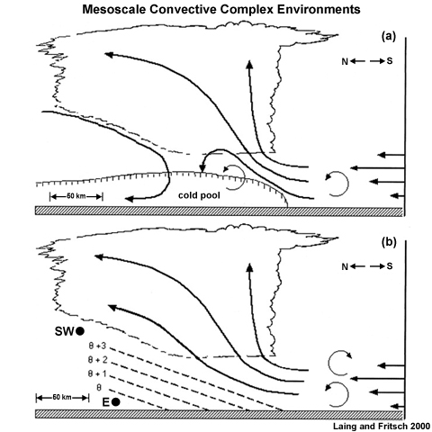
MCC formation can happen with or without large-scale forcing (Fig. 7.101). If the sign of cold-pool-induced circulation is always the same as that associated with the ambient shear then the convection will be long-lived. This secondary mechanism (Fig. 7.101b) is likely in Northern Australia MCCs that have weak baroclinic forcing. In that region, MCCs are associated with the monsoon trough and are often precursors to tropical cyclones.

Large-scale environments conducive to MCCs usually have: a low-level jet of air with low static stability, high equivalent potential temperature (θe), oriented nearly perpendicular to the baroclinic zone, flowing towards the genesis region, and is forced to rise over a relatively shallow, surface-based layer of relatively cool air.235,239 The surface cool layer is overlaid by pronounced warm advection accompanied by strong lower-tropospheric veering. A local maximum in absolute humidity and a local minimum in static stability favored MCC initiation. Low-level convergence, upper-level divergence, and a mid-level vorticity maximum, and weak mid-level shear are also characteristic of the mean genesis environment. West of Borneo in the Maritime Continent is a common location for MCCs.269,270

 Conceptual diagram of the formation of MCCs offshore Borneo, over the South China Sea
Fig. 7.102. Conceptual diagram of the formation of MCCs offshore Borneo, over the South China Sea.269

There, favorable strong low-level convergence and low-level wind shear are produced from the interaction of northeast monsoon winds and the sea breeze269 (Fig. 7.102).271 MCCs also form along the shores of northwest South America, where initial thunderstorms develop along the mountain slopes in response to diurnal heating of elevated terrain. Then it is suggested that thermally-forced gravity waves propagate offshore and initiate MCCs during the nighttime.271

Non-squall cluster environment

A distinctive feature of non-squall cluster environments is the absence of strong shear between 700 and 250 hPa. They have deep layer moisture and maximum low-level convergence during the growing stage of the system lifecycle. Maximum vertical motion is close to 300 hPa and occurs during the mature phase.

During GATE, clusters formed where the mean 950-650 hPa environmental shear was about 6 m s-1 and mostly parallel to the lines. Non-squall clusters are similar to squall clusters in terms of conditional instability and formation relative to the African easterly wave trough. However, large, longer-lived non-squall clusters tend to move at less than the speed of the easterly wave and dissipate once they fall behind the trough axis. Similar winter monsoon clusters near Borneo are initiated from offshore breezes and a quasi-stationary vortex that develops cross-equatorial monsoon flow (Section 3.5.3Section 3.5.3).

1. Kodama, Y., 1992: Large-scale common features of subtropical precipitation zones (the bai-u frontal zone, the SPCZ, and the SACZ). Part I: Characteristics of subtropical frontal zones. J. Meteor. Soc. Japan, 70, 813-836.
2. Vincent, D. G., 1994: The South Pacific Convergence Zone (SPCZ): A review. Mon. Wea. Rev., 122, 1949-1970.
3. Riehl, H., 1979: Climate and weather in the tropics. Academic Press, 611.
4. Holton, J. R., 2004: An introduction to dynamic meteorology, fourth edition. Academic Press, 122, 535.
5. Ramage, C. S., 1995: Forecasters Guide to Tropical Meteorology. Updated. Air Weather Service, Scott AFB, IL.
6. Piersig, W., 1944: The cyclonic disturbances of the sub-tropical eastern North Atlantic. Bull. Amer. Meteor. Soc., 25, 2-17.
7. Regula, H., 1936: Druckschwankungen und tornados an der westküste von afrika. Ann. Hydrogr. Mar. Meteor., 64, 107-111.
8. Simpson, R. H., Frank, N., Shideler, D. and Johnson, H., 1969: Atlantic tropical disturbances of 1968. Mon. Wea. Rev., 97, 240-255.
9. Carlson, T. N., 1969: Synoptic histories of three African disturbances that developed into Atlantic hurricanes. Mon. Wea. Rev., 97, 256-276.
10. Zehnder, J. A., 1991: The interaction of planetary-scale tropical easterly waves with topography: A mechanism for the initiation of tropical cyclones. J. Atmos. Sci., 48, 1217-1230.
11. Zehnder, J. A., Powell, D. M. and Ropp, D. L., 1999: The interaction of easterly waves, orography, and the intertropical convergence zone in the genesis of eastern Pacific tropical cyclones. Mon. Wea. Rev., 127, 1566-1585.
12. Parker, D., Thorncroft, C., Burton, R. and Diongue-Niang, A., 2005: Analysis of the African easterly jet, using aircraft observations from the JET2000 experiment. Quart. J. Roy. Meteor. Soc., 131, 1461-1482.
13. Jones, C., Mahowald, N. and Luo, C., 2004: Observational evidence of African desert dust intensification of easterly waves. Geophys. Res. Lett., 31, 17.
14. Shinn, E. A., Smith, G. W., Prospero, J. M., Betzer, P., Hayes, M. L., Garrison, V. and Barber, R. T., 2000: African dust and the demise of Caribbean coral reefs. Geophys. Res. Lett., 27, 3029-3032.
15. Thorncroft, C. and Hodges, K., 2001: African easterly wave variability and its relationship to Atlantic tropical cyclone activity. J. Climate, 14, 1166-1179.
16. Carlson, T. N., 1969: Some remarks on African disturbances and their progress over the tropical Atlantic. Mon. Wea. Rev., 97, 716-726.
17. Grist, J. P., 2002: Easterly waves over Africa. Part I: The seasonal cycle and contrasts between wet and dry years. Mon. Wea. Rev., 130, 197-211.
18. Landsea, C. W., 1993: A climatology of intense (or major) Atlantic hurricanes. Mon. Wea. Rev., 121, 1703-1713.
19. Reed, R. J., Norquist, D. C. and Recker, E. E., 1977: The structure and properties of African wave disturbances as observed during phase III of GATE. Mon. Wea. Rev., 105, 317-333.
20. Kiladis, G. N., Thorncroft, C. D. and Hall, N. M. J., 2006: Three-dimensional structure and dynamics of African easterly waves. Part I: Observations. J. Atmos. Sci., 63, 2212-2230.
21. Chen, T., 2006: Characteristics of African easterly waves depicted by ECMWF reanalyses for 1991–2000. Mon. Wea. Rev., 134, 3539-3566.
22. De Felice, P., Monkam, D., Viltard, A. and Ouss, C., 1990: Characteristics of north African 6–9 day waves during summer 1981. Mon. Wea. Rev., 118, 2624-2633.
23. Viltard, A., de Felice, P. and Oubuih, J., 1997: Comparison of the African and the 6–9 day wave-like disturbance patterns over west-Africa and the tropical Atlantic during summer 1985. Meteor. Atmos. Phys., 62, 91-99.
24. Diedhiou, A., Janicot, S., Viltard, A., de Felice, P. and Laurent, H., 1999: Easterly wave regimes and associated convection over west Africa and tropical Atlantic: Results from the NCEP/NCAR and ECMWF reanalyses. Clim. Dyn., 15, 795-822.
25. Pytharoulis, I. and Thorncroft, C., 1999: The low-level structure of African easterly waves in 1995. Mon. Wea. Rev., 127, 2266-2280.
26. Riehl, H., 1945: Waves in the easterlies and the polar front in the tropics. University of Chicago Press, 79 pp.
27. Diaz, M. and Aiyyer, A., 2013: Energy dispersion in African easterly waves. J. Atmos. Sci., 70, 130-145.
28. Charney, J. and Stern, M. E., 1962: On the stability of internal baroclinic jets in a rotating atmosphere. J. Atmos. Sci., 19, 113-126.
29. Burpee, R. W., 1972: The origin and structure of easterly waves in the lower troposphere of north Africa. J. Atmos. Sci., 29, 77-90.
30. Thorncroft, C. D. and Hoskins, B. J., 1994: An idealized study of African easterly waves. I: A linear view. Quart. J. Roy. Meteor. Soc., 120, 953-982.
31. Thorncroft, C. D. and Hoskins, B. J., 1994: An idealized study of African easterly waves. II: A nonlinear view. Quart. J. Roy. Meteor. Soc., 120, 983-1015.
32. Thorncroft, C. D. and Blackburn, M., 1999: Maintenance of the African easterly jet. Quart. J. Roy. Meteor. Soc., 125, 763-786.
33. Dickinson, M. and Molinari, J., 2000: Climatology of sign reversals of the meridional potential vorticity gradient over Africa and Australia. Mon. Wea. Rev., 128, 3890-3900.
34. Hall, N. M. J., Kiladis, G. N. and Thorncroft, C. D., 2006: Three-dimensional structure and dynamics of African easterly waves. Part II: Dynamical modes. J. Atmos. Sci., 63, 2231-2245.
35. Leroux, S., Hall, N. M. J. and Kiladis, G. N., 2011: Intermittent African easterly wave activity in a dry atmospheric model: Influence of the extratropics. J. Climate, 24, 5378-5396.
36. Thorncroft, C. D., Hall, N. M. J. and Kiladis, G. N., 2008: Three-dimensional structure and dynamics of African easterly waves. Part III: Genesis. J. Atmos. Sci., 65, 3596-3607.
37. Hsieh, J. and Cook, K. H., 2005: Generation of African easterly wave disturbances: Relationship to the African easterly jet. Mon. Wea. Rev., 133, 1311-1327.
38. Berry, G. J. and Thorncroft, C. D., 2012: African easterly wave dynamics in a mesoscale numerical model: The upscale role of convection. J. Atmos. Sci., 69, 1267-1283.
39. Mekonnen, A. and Rossow, W. B., 2011: The interaction between deep convection and easterly waves over tropical north Africa: A weather state perspective. J. Climate, 24, 4276-4294.
40. Mozer, J. B. and Zehnder, J. A., 1996: Lee vorticity production by large-scale tropical mountain ranges. Part II: A mechanism for the production of African waves. J. Atmos. Sci., 53, 539-549.
41. Diaz, M. and Aiyyer, A., 2013: The genesis of African easterly waves by upstream development. J. Atmos. Sci., 70, 3492-3512.
42. Janiga, M. A. and Thorncroft, C. D., 2013: Regional differences in the kinematic and thermodynamic structure of African easterly waves. Quart. J. Roy. Meteor. Soc., 139, 1598-1614.
43. Mekonnen, A., Thorncroft, C. D. and Aiyyer, A. R., 2006: Analysis of convection and its association with African easterly waves. J. Climate, 19, 5405-5421.
44. Hodges, K. I. and Thorncroft, C. D., 1997: Distribution and statistics of African mesoscale convective weather systems based on the ISCCP Meteosat imagery. Mon. Wea. Rev., 125, 2821-2837.
45. Laing, A. G., Carbone, R., Levizzani, V. and Tuttle, J., 2008: The propagation and diurnal cycles of deep convection in northern tropical Africa. Quart. J. Roy. Meteor. Soc., 134, 93-109.
46. Berry, G. J. and Thorncroft, C. D., 2005: Case study of an intense African easterly wave. Mon. Wea. Rev., 133, 752-766.
47. Lin, Y., Robertson, K. E. and Hill, C. M., 2005: Origin and propagation of a disturbance associated with an African easterly wave as a precursor of Hurricane Alberto (2000). Mon. Wea. Rev., 133, 3276-3298.
48. Fink, A. H., Vincent, D. G. and Ermert, V., 2006: Rainfall types in the west African Sudanian zone during the summer monsoon 2002. Mon. Wea. Rev., 134, 2143-2164.
49. Guy, N., Rutledge, S. A. and Cifelli, R., 2011: Radar characteristics of continental, coastal, and maritime convection observed during AMMA/NAMMA. Quart. J. Roy. Meteor. Soc., 137, 1241-1256.
50. Payne, S. W. and McGarry, M. M., 1977: The relationship of satellite inferred convective activity to easterly waves over west Africa and the adjacent ocean during phase III of GATE. Mon. Wea. Rev., 105, 413-420.
51. Reed, R. J., Norquist, D. C. and Recker, E. E., 1977: The structure and properties of African wave disturbances as observed during phase III of GATE. Mon. Wea. Rev., 105, 317-333.
52. Burpee, R. W., 1974: Characteristics of the north African easterly waves during the summers of 1968 and 1969. J. Atmos. Sci., 31, 1556-1570.
53. Cifelli, R., Lang, T., Rutledge, S. A., Guy, N., Zipser, E. J., Zawislak, J. and Holzworth, R., 2010: Characteristics of an African easterly wave observed during NAMMA. J. Atmos. Sci., 67, 3-25.
54. Reiner, A. and Fink, A., 2003: Spatio-temporal variability of the relation between African easterly waves and west African squall lines in 1998 and 1999. J. Geophys. Rev. 1, 2449.
55. Duvel, J. P., 1990: Convection over tropical Africa and the Atlantic ocean during northern summer. Part II: Modulation by easterly waves. Mon. Wea. Rev., 118, 1855-1868.
56. Diedhiou, A., Janicot, S., Viltard, A. and de Félice, P., 2001: Composite patterns of easterly disturbances over west Africa and the tropical Atlantic: A climatology from the 1979–95 NCEP/NCAR reanalyses. Clim. Dyn., 18, 241-253.
57. Mathon, V., Diedhiou, A. and Laurent, H., 2002: Relationship between easterly waves and mesoscale convective systems over the Sahel. Geophys. Res. Lett., 29, 57-1-57-4.
58. Schwendike, J. and Jones, S. C., 2010: Convection in an African easterly wave over west Africa and the eastern Atlantic: A model case study of Helene (2006). Quart. J. Roy. Meteor. Soc., 136, 364-396.
59. Taylor, C. M., Parker, D. J., Lloyd, C. R. and Thorncroft, C. D., 2005: Observations of synoptic-scale land surface variability and its coupling with the atmosphere. Quart. J. Roy. Meteor. Soc., 131, 913-937.
60. Matsuno, T., 1966: Quasi-geostrophic motions in the equatorial area. J. Meteor. Soc., Japan, 44, 25-43.
61. Wheeler, M. and Kiladis, G. N., 1999: Convectively coupled equatorial waves: Analysis of clouds and temperature in the wavenumber-frequency domain. J. Atmos. Sci., 56, 374-399.
62. Roundy, P. E. and Frank, W. M., 2004: A climatology of waves in the equatorial region. J. Atmos. Sci., 61, 2105-2132.
63. Berry, G., Thorncroft, C. and Hewson, T., 2007: African easterly waves during 2004—Analysis using objective techniques. Mon. Wea. Rev., 135, 1251-1267.
64. Zawislak, J. and Zipser, E. J., 2010: Observations of seven African easterly waves in the east Atlantic during 2006. J. Atmos. Sci., 67, 26-43.
65. Sall, S. M. and Sauvageot, H., 2005: Cyclogenesis off the African coast: The case of Cindy in August 1999. Mon. Wea. Rev., 133, 2803-2813.
66. Avila, L. A. and Pasch, R. J., 1992: Atlantic tropical systems of 1991. Mon. Wea. Rev., 120, 2688-2696.
67. Chen, T., Wang, S. and Clark, A. J., 2008: North Atlantic hurricanes contributed by African easterly waves north and south of the African easterly jet. J. Climate, 21, 6767-6776.
68. Hopsch, S. B., Thorncroft, C. D. and Tyle, K. R., 2009: Analysis of African easterly wave structures and their role in influencing tropical cyclogenesis. Mon. Wea. Rev., 138, 1399-1419.
69. Ross, R. S., Krishnamurti, T. N., Pattnaik, S. and Simon, A., 2009: Energy transformation and diabatic processes in developing and nondeveloping African easterly waves observed during the NAMMA project of 2006. Wea. Forecasting, 24, 1524-1548.
70. Chiao, S. and Jenkins, G. S., 2010: Numerical investigations on the formation of Tropical Storm Debby during NAMMA-06. Wea. Forecasting, 25, 866-884.
71. Vizy, E. K. and Cook, K. H., 2009: Tropical storm development from African easterly waves in the eastern Atlantic: A comparison of two successive waves using a regional model as part of NASA AMMA 2006. J. Atmos. Sci., 66, 3313-3334.
72. Zipser, E. J., Twohy, C. H., Tsay, S., Hsu, N. C., Heymsfield, G. M., Thornhill, K. L., Tanelli, S., Ross, R., Krishnamurti, T. N., Ji, Q., Jenkins, G., Ismail, S., Ferrare, R., Chen, G., Browell, E. V., Anderson, B., Hood, R., Goodman, H. M., Heymsfield, A., Halverson, J., Dunion, J. P., Douglas, M. and Cifelli, R., 2009: The Saharan Air Layer and the fate of African easterly waves—NASA's AMMA field study of tropical cyclogenesis. Bull. Amer. Meteor. Soc., 90, 1137-1156.
73. Frank, N. L., 1969: The "inverted V” cloud pattern — an easterly wave? Mon. Wea. Rev., 97, 130-140.
74. Serra, Y. L., Kiladis, G. N. and Hodges, K. I., 2010: Tracking and mean structure of easterly waves over the intra-Americas sea. J. Climate, 23, 4823-4840.
75. Ventrice, M. J., Thorncroft, C. D. and Roundy, P. E., 2011: The Madden Julian Oscillation's influence on African easterly waves and downstream tropical cyclogenesis. Mon. Wea. Rev., 139, 2704-2722.
76. Alaka, G. J. and Maloney, E. D., 2011: The influence of the MJO on upstream precursors to African easterly waves. J. Climate, 25, 3219-3236.
77. Ventrice, M. J., Thorncroft, C. D. and Janiga, M. A., 2011: Atlantic tropical cyclogenesis: A three-way interaction between an African easterly wave, diurnally varying convection, and a convectively coupled atmospheric kelvin wave. Mon. Wea. Rev., 140, 1108-1124.
78. Kawatani, Y., Watanabe, S., Sato, K., Dunkerton, T. J., Miyahara, S. and Takahashi, M., 2009: The roles of equatorial trapped waves and internal Inertia–Gravity waves in driving the quasi-biennial oscillation. Part I: Zonal mean wave forcing. J. Atmos. Sci., 67, 963-980.
79. Kiladis, G. N., Wheeler, M. C., Haertel, P. T. and Roundy, P. E., 2009: Convectively coupled equatorial waves. Rev. Geophys, 47, 2.
80. Wheeler, M., Kiladis, G. N. and Webster, P. J., 2000: Large-scale dynamical fields associated with convectively coupled equatorial waves. J. Atmos. Sci., 57, 613-640.
81. Chen, S. S., Houze, R. A. and Mapes, B. E., 1996: Multiscale variability of deep convection in relation to large-scale circulation in TOGA COARE. J. Atmos. Sci., 53, 1380-1409.
82. Takayabu, Y. N., 1994: Large-scale cloud disturbances associated with equatorial waves. J. Meteor. Soc. Japan., 72, 433-449.
83. Takayabu, Y. N., Lau, K. and Sui, C., 1996: Observation of a quasi-2-day wave during TOGA COARE. Mon. Wea. Rev., 124, 1892-1913.
84. Haertel, P. T. and Kiladis, G. N., 2004: Dynamics of 2-day equatorial waves. J. Atmos. Sci., 61, 2707-2721.
85. Tulich, S. N. and Kiladis, G. N., 2012: Squall lines and convectively coupled gravity waves in the tropics: Why do most cloud systems propagate westward? J. Atmos. Sci., 69, 2995-3012.
86. Tindall, J. C., Thuburn, J. and Highwood, E. J., 2006: Equatorial waves in the lower stratosphere. I: A novel detection method. Quart. J. Roy. Meteor. Soc., 132, 177-194.
87. Sadler, J. C., 1967: The tropical upper tropospheric trough as a secondary source of typhoons and a primary source of trade-wind disturbances. Final Report. Hawaii Institute of Geophysics, University of Hawaii.
88. Sadler, J. C. and Wann, T. C., 1984: Mean upper tropospheric flow over the global tropics. AWS/TR-83/002 Air Weather Service (MAC), Scott AFB, Illinois 62225, 48 pp. volume 2.
89. Fitzpatrick, P. J., Knaff, J. A., Landsea, C. W. and Finley, S. V., 1995: Documentation of a systematic bias in the aviation model's forecast of the Atlantic tropical upper-tropospheric trough: Implications for tropical cyclone forecasting. Wea. Forecasting, 10, 433-446.
90. Patla, J. E., Stevens, D. and Barnes, G. M., 2009: A conceptual model for the influence of TUTT cells on tropical cyclone motion in the northwest Pacific Ocean. Wea. Forecasting, 24, 1215-1235.
91. Kodama, K. R. and Businger, S., 1998: Weather and forecasting challenges in the Pacific Region of the National Weather Service. Wea. Forecasting, 13, 523-546.
92. Morrison, I. and Businger, S., 2001: Synoptic structure and evolution of a Kona low. Wea. Forecasting, 16, 81-98.
93. Caruso, S. and Businger, S., 2006: Synoptic climatology of subtropical cyclogenesis. Wea. Forecasting, 20, 193-205.
94. Evans, J. L. and Guishard, M. P., 2009: Atlantic subtropical storms. Part I: Diagnostic criteria and composite analysis. Mon. Wea. Rev., 137, 2065-2080.
95. Thorncroft, C. D., Hoskins, B. J. and McIntyre, M. E., 1993: Two paradigms of baroclinic-wave life-cycle behaviour. Quart. J. Roy. Meteor. Soc., 119, 17-55.
96. Postel, G. A. and Hitchman, M. H., 1999: A climatology of Rossby wave breaking along the subtropical tropopause. J. Atmos. Sci., 56, 359-373.
97. Bister, M. and Emanuel, K. A., 1997: The genesis of Hurricane Guillermo: TEXMEX analyses and a modeling study. Mon. Wea. Rev., 125, 2662-2682.
98. Guishard, M. P., 2006: Atlantic subtropical storms: Climatology and characteristics. Dept. of Meteorology. PhD Thesis, Penn. State Univ., 158pp.
99. Tam, C. and Li, T., 2006: The origin and dispersion characteristics of the observed tropical summertime synoptic-scale waves over the western Pacific. Mon. Wea. Rev., 134, 1630-1646.
100. Davis, C. A., 2010: Simulations of subtropical cyclones in a baroclinic channel model. J. Atmos. Sci., 67, 2871-2892.
101. Hart, N. C. G., Reason, C. J. C. and Fauchereau, N., 2010: Tropical–Extratropical interactions over southern Africa: Three cases of heavy summer season rainfall. Mon. Wea. Rev., 138, 2608-2623.
102. Emanuel, K. A., 1987: Air-sea interaction model of intraseasonal oscillations in the tropics. J. Atmos. Sci., 44, 2324-2340.
103. Parker, D. J. and Thorpe, A. J., 1995: Conditional convective heating in a baroclinic atmosphere: A model of convective frontogenesis. J. Atmos. Sci., 52, 1699-1711.
104. Davis, C. and Bosart, L. F., 2002: Numerical simulations of the genesis of Hurricane Diana (1984). Part II: Sensitivity of track and intensity prediction. Mon. Wea. Rev., 130, 1100-1124.
105. Bosart, L. F. and Bartlo, J. A., 1991: Tropical storm formation in a baroclinic environment. Mon. Wea. Rev., 119, 1979-2013.
106. Simpson, J., Halverson, J. B., Ferrier, B. S., Petersen, W. A., Simpson, R. H., Blakeslee, R. and Durden, S. L., 1998: On the role of “hot towers” in tropical cyclone formation. Meteor. Atmos. Phys., 67, 15-35.
107. Hulme, A. L. and Martin, J. E., 2009: Synoptic- and frontal-scale influences on tropical transition events in the Atlantic Basin. Part I: A six-case survey. Mon. Wea. Rev., 137, 3605-3625.
108. Krishnamurti, T. N., Kanamitsu, M., Godbole, R., Chang, C. B., Carr, F. and Chow, J. H., 1975: Study of a monsoon depression (I). synoptic structure. J. Meteor. Soc. Japan, 53, 227-239.
109. Sikka, D., 1977: Some aspects of the life history, structure, and movement of monsoon depressions. Pure Appl. Geophys., 115, 1501-1529.
110. Chen, T. and Weng, S., 1999: Interannual and intraseasonal variations in monsoon depressions and their westward-propagating predecessors. Mon. Wea. Rev., 127, 1005-1020.
111. NASA, 2004: Typhooon Chanthu. [Available at http://earthobservatory.nasa.gov/NaturalHazards/view.php?id=13316 ].
112. Godbole, R. V., 1977: The composite structure of the monsoon depression. Tellus, 29, 25-40.
113. S. Rajamani, D. N. S., 2010: Some dynamical characteristics and thermal structure of monsoon depressions over the Bay of Bengal. Tellus, 41A, 255-269.
114. Douglas, M. W., 1992: Structure and dynamics of two monsoon depressions. Part I: Observed structure. Mon. Wea. Rev., 120, 1524-1547.
115. Rao, Y. P., 1976: Southwest monsoon. Meteor. Mono. India Meteorological Department, New Delhi, 367pp.
116. Krishnamurti, T. N., 1979: Tropical Meteorology. Compendium of Meteorology II, World Meteorological Organization, 428 pp.
117. Krishnamurthy, V. and Shukla, J., 2007: Intraseasonal and seasonally persisting patterns of Indian monsoon rainfall. J. Climate, 20, 3-20.
118. Yoon, J. and Huang, W., 2012: 02 Indian monsoon depression: Climatology and variability. Modern Climatology, Book 13.
119. Saha, K., Sanders, F. and Shukla, J., 1981: Westward propagating predecessors of monsoon depressions. Mon. Wea. Rev., 109, 330-343.
120. Chen, T., Yoon, J. and Wang, S., 2005: Westward propagation of the Indian monsoon depression. Tellus, 57, 758-769.
121. Yoon, J. and Chen, T., 2005: Water vapor budget of the Indian monsoon depression. Tellus, 57, 758-769.
122. Saha, K. and Saha, S., 1988: Thermal budget of a monsoon depression in the Bay of Bengal during FGGE-MONEX 1979. Mon. Wea. Rev., 116, 242-255.
123. Lindzen, R. S., 1974: Wave-CISK in the tropics. J. Atmos. Sci., 31, 156-179.
124. Boos, W. R., Hurley, J. V. and Murthy, V. S., 2014: Adiabatic westward drift of Indian monsoon depressions. Quart. J. Roy. Meteor. Soc., doi: 10.1002/qj.2454.
125. Miller, F. R. and Keshavamurthy, R. N., 1968: Structure of an Arabian Sea summer monsoon system. Meteor. Mono. 1, 94.
126. Carr, F. H., 1977: Mid-tropospheric cyclones of the summer monsoon. Pure Appl. Geophys, 115, 1383-1412.
127. Keen, R. A., 1982: The role of cross-equatorial tropical cyclone pairs in the southern oscillation. Mon. Wea. Rev., 110, 1405-1416.
128. Lander, M. A., 1990: Evolution of the cloud pattern during the formation of tropical cyclone twins symmetrical with respect to the equator. Mon. Wea. Rev., 118, 1194-1202.
129. Lukas, R., Hayes, S. P. and Wyrtki, K., 1984: Equatorial sea level response during the 1982–1983 El Niño. J. Geophys. Res., 89, 10425-10430.
130. Luther, D. S., Harrison, D. E. and Knox, R. A., 1983: Zonal winds in the central equatorial Pacific and El Niño. Science, 222, 327-330.
131. Bjerknes, J., 1969: Atmospheric teleconnections from the equatorial Pacific. Mon. Wea. Rev., 97, 163-172.
132. Horel, J. D. and Wallace, J. M., 1981: Planetary-scale atmospheric phenomena associated with the Southern Oscillation. Mon. Wea. Rev., 109, 813-829.
133. Wallace, J. M. and Gutzler, D. S., 1981: Teleconnections in the geopotential height field during the northern hemisphere winter. Mon. Wea. Rev., 109, 784-812.
134. Zhang, C., 2005: Madden-Julian Oscillation. Rev. Geophys., 43, 2.
135. Jones, C., Waliser, D. E., Lau, K. M. and Stern, W., 2004: The Madden–Julian Oscillation and its impact on northern hemisphere weather predictability. Mon. Wea. Rev., 132, 1462-1471.
136. Kiladis, G. N. and Weickmann, K. M., 1992: Extratropical forcing of tropical Pacific convection during northern winter. Mon. Wea. Rev., 120, 1924-1939.
137. Knippertz, P., 2007: Tropical–extratropical interactions related to upper-level troughs at low latitudes. Dyn. Atmos. Oceans, 43, 36-62.
138. Sumi, A., 1985: A study on cold surges around the Tibetan Plateau by using numerical models. Meteor. Atmos. Physics, 63, 377-396.
139. Boyle, J.S., Chen, T, 1987: Synoptic aspects of the wintertime east Asian monsoon. Mesoscale Meteorology, Chang, C.P., Krishnamurti, T.N. Ed., Oxford University Press, 125-160.
140. Chang, C., Erickson, J. and Lau, K., 1979: Northeasterly cold surges and near-equatorial disturbances over the winter MONEX area during December 1974. Part I: Synoptic aspects. Mon. Wea. Rev., 107, 812-829.
141. Yokoi, S. and Matsumoto, J., 2008: Collaborative effects of cold surge and tropical depression-type disturbance on heavy rainfall in central Vietnam. Mon. Wea. Rev., 136, 3275-3287.
142. Zhang, Y., Sperber, K. R. and Boyle, J. S., 1996: Climatology of east Asian winter monsoon and cold surges: Results from the 1979-1995 NCEP/NCAR reanalysis. Program for Climate Model Diagnosis and Intercomparison, University of California, Lawrence Livermore National Laboratory.
143. Garreaud, R., 2000: Cold air incursions over subtropical South America: Mean structure and dynamics. Mon. Wea. Rev., 128, 2544-2559.
144. Vera, C., Higgins, W., Amador, J., Ambrizzi, T., Garreaud, R., Gochis, D., Gutzler, D., Lettenmaier, D., Marengo, J., Mechoso, C. R., Nogues-Paegle, J., Dias, P. L. S. and Zhang, C., 2006: Toward a unified view of the American monsoon systems. J. Climate, 19, 4977-5000.
145. Lupo, A. R., Nocera, J. J., Bosart, L. F., Hoffman, E. G. and Knight, D. J., 2001: South American cold surges: Types, composites, and case studies. Mon. Wea. Rev., 129, 1021-1041.
146. Marengo, J. A., Nobre, C. A. and Culf, A. D., 1997: Climatic impacts of “Friagens” in forested and deforested areas of the Amazon Basin. J. Appl. Meteor., 36, 1553-1566.
147. Hamilton, M. G. and Tarifa, J., 1978: Synoptic aspects of a polar outbreak leading to frost in tropical Brazil, July 1972. Mon. Wea. Rev., 106, 1545-1556.
148. Fortune, M. A. and Kousky, V. E., 1983: Two severe freezes in Brazil: Precursors and synoptic evolution. Mon. Wea. Rev., 111, 181-196.
149. Myers, V. A., 1964: A Cold front invasion of Southern Venezuela. Mon. Wea. Rev., 92, 513-521.
150. Garcia, O., Bosart, L. and DiMego, G., 1978: On the nature of the winter season rainfall in the Dominican Republic. Mon. Wea. Rev., 106, 961-982.
151. DiMego, G. J., Bosart, L. F. and Endersen, G. W., 1976: An examination of the frequency and mean conditions surrounding frontal incursions into the Gulf of Mexico and Caribbean Sea. Mon. Wea. Rev., 104, 709-718.
152. Henry, W. K., 1979: Some aspects of the fate of cold fronts in the Gulf of Mexico. Mon. Wea. Rev., 107, 1078-1082.
153. Fermor, J., 1971: The weather during northers at Kingston, Jamaica. J. Trop. Geogr., 32, 31-37.
154. Horvath, N. and Henry, W., 1980: Some aspects of cold fronts in Belize. Nat. Wea. Dig., 5, 25-32.
155. Schultz, D. M., Bracken, W. E. and Bosart, L. F., 1998: Planetary- and synoptic-scale signatures associated with Central American cold surges. Mon. Wea. Rev., 126, 5-27.
156. Reding, P. J., 1992: The Central American cold surge: An observational analysis of the deep southward penetration of North American cold fronts. Texas A and M Univ, College Station.
157. Laing, A. G., 2004: Cases of heavy precipitation and flash floods in the Caribbean during El Niño winters. J. HydroMeteor., 5, 577-594.
158. Brooks, B., 1987: Forecasting the "Atemporalado". Honduras. AWS/FM-87/001, Air Weather Service, Scott AFB, Illinois.
159. Ramage, C. S., 2013: Forecasters Guide to Tropical Meteorology. Updated. AWS/TR-95/001, Air Weather Service, Scott AFB IL., 496.
160. Kiladis, G. N. and Weickmann, K. M., 1997: Horizontal structure and seasonality of large-scale circulations associated with submonthly tropical convection. Mon. Wea. Rev., 125, 1997-2013.
161. Webster, P. and Holton, J., 1982: Wave propagation through a zonally varying basic flow: The influences of midlatitude forcing in the equatorial regions. J. Atmos. Sci., 39, 722-733.
162. Hoskins, B. J. and Ambrizzi, T., 1993: Rossby wave propagation on a realistic longitudinally varying flow. J. Atmos. Sci., 50, 1661-1671.
163. Liebmann, B., Kiladis, G. N., Carvalho, L. M. V., Jones, C., Vera, C. S., Bladé, I. and Allured, D., 2009: Origin of convectively coupled Kelvin waves over South America. J. Climate, 22, 300-315.
164. Matthews, A. J. and Kiladis, G. N., 1999: The Tropical–Extratropical interaction between high-frequency transients and the Madden–Julian Oscillation. Mon. Wea. Rev., 127, 661-677.
165. Jones, C., Waliser, D. E., Lau, K. and Stern, W., 2004: Global occurrences of extreme precipitation and the Madden-Julian Oscillation: Observations and predictability. J. Climate, 17, 4575-4589.
166. Hsu, H., Hoskins, B. J. and Jin, F., 1990: The 1985/86 intraseasonal oscillation and the role of the extratropics. J. Atmos. Sci., 47, 823-839.
167. Hoskins, B. J. and Yang, G., 2000: The equatorial response to higher-latitude forcing. J. Atmos. Sci., 57, 1197-1213.
168. Moore, R. W., Martius, O. and Spengler, T., 2010: The modulation of the subtropical and extratropical atmosphere in the Pacific basin in response to the Madden–Julian Oscillation. Mon. Wea. Rev., 138, 2761-2779.
169. Kiladis, G. N. and Feldstein, S. B., 1994: Rossby wave propagation into the tropics in two GFDL general circulation models. Climate Dynamics, 9, 245-252.
170. Adames, Á F., Patoux, J. and Foster, R. C., 2013: The contribution of extratropical waves to the MJO wind field. J. Atmos. Sci., 71, 155-176.
171. Lin, J., Kiladis, G. N., Mapes, B. E., Weickmann, K. M., Sperber, K. R., Lin, W., Wheeler, M. C., Schubert, S. D., Del Genio, A., Donner, L. J., Emori, S., Gueremy, J., Hourdin, F., Rasch, P. J., Roeckner, E. and Scinocca, J. F., 2006: Tropical intraseasonal variability in 14 IPCC AR4 climate models. Part I: Convective signals. J. Climate, 19, 2665-2690.
172. Zhang, C., 2013: Madden-Julian oscillation: Bridging weather and climate. Bull. Amer. Meteor. Soc., 94, 1849-1870.
173. Zhu, Y. and Newell, R. E., 1998: A proposed algorithm for moisture fluxes from atmospheric rivers. Mon. Wea. Rev., 126, 725-735.
174. Knippertz, P. and Martin, J. E., 2007: A Pacific moisture conveyor belt and its relationship to a significant precipitation event in the semiarid southwestern United States. Wea. Forecasting, 22, 125-144.
175. Knippertz, P., Wernli, H. and Gläser, G., 2012: A global climatology of tropical moisture exports. J. Climate, 26, 3031-3045.
176. Knippertz, P. and Fink, A. H., 2009: Prediction of dry-season precipitation in tropical west Africa and its relation to forcing from the extratropics. Wea. Forecasting, 24, 1064-1084.
177. Knippertz, P. and Wernli, H., 2010: A Lagrangian climatology of tropical moisture exports to the northern hemispheric extratropics. J. Climate, 23, 987-1003.
178. Bao, J., Michelson, S. A., Neiman, P. J., Ralph, F. M. and Wilczak, J. M., 2006: Interpretation of enhanced integrated water vapor bands associated with extratropical cyclones: Their formation and connection to tropical moisture. Mon. Wea. Rev., 134, 1063-1080.
179. Kidder, S. Q. and Jones, A. S., 2007: A blended satellite total precipitable water product for operational forecasting. J. Atmos. Oceanic Technol., 24, 74-81.
180. Dettinger, M. D., Ralph, F. M., Das, T., Neiman, P. J. and Cayan, D. R., 2011: Atmospheric rivers, floods and the water resources of California. Water, 3, 445-478.
181. Ralph, F. M., Neiman, P. J. and Wick, G. A., 2004: Satellite and CALJET aircraft observations of atmospheric rivers over the eastern north Pacific Ocean during the winter of 1997/98. Mon. Wea. Rev., 132, 1721-1745.
182. Neiman, P. J., Ralph, F. M., Wick, G. A., Lundquist, J. D. and Dettinger, M. D., 2008: Meteorological characteristics and overland precipitation impacts of atmospheric rivers affecting the west coast of North America based on eight years of SSM/I satellite observations. J. Hydrometeor., 9, 22-47.
183. Ralph, F. M., Neiman, P. J. and Rotunno, R., 2005: Dropsonde observations in low-level jets over the northeastern Pacific Ocean from CALJET-1998 and PACJET-2001: Mean vertical-profile and atmospheric-river characteristics. Mon. Wea. Rev., 133, 889-910.
184. Waliser, D. E., Moncrieff, M. W., Burridge, D., Fink, A. H., Gochis, D., Goswami, B. N., Guan, B., Harr, P., Heming, J., Hsu, H., Jakob, C., Janiga, M., Johnson, R., Jones, S., Knippertz, P., Marengo, J., Nguyen, H., Pope, M., Serra, Y., Thorncroft, C., Wheeler, M., Wood, R. and Yuter, S., 2011: The “year” of tropical convection (May 2008–April 2010): Climate variability and weather highlights. Bull. Amer. Meteor. Soc., 93, 1189-1218.
185. Lavers, D. A., Allan, R. P., Wood, E. F., Villarini, G., Brayshaw, D. J. and Wade, A. J., 2011: Winter floods in Britain are connected to atmospheric rivers. Geophys. Res. Lett., 38, 23.
186. Met Office, F. R., 2014: Record wet January for parts of southern Britain. [Available on line at: http://www.earthobservatory.nasa.gov/IOTD/view.php?id=83157].
187. NASA earth observatory, 2014: Somerset levels swamped. [Available on line at: http://www.earthobservatory.nasa.gov/IOTD/view.php?id=83157].
188. Gimeno, L., Nieto, R., Vázquez, M. and Lavers, D. A., 2014: Atmospheric rivers: A mini-review. Atmos. Sci., 2, 2.
189. Ralph, F. M., Neiman, P. J., Kiladis, G. N., Weickmann, K. and Reynolds, D. W., 2010: A multiscale observational case study of a Pacific atmospheric river exhibiting tropical–extratropical connections and a mesoscale frontal wave. Mon. Wea. Rev., 139, 1169-1189.
190. Higgins, R. W. and Mo, K. C., 1997: Persistent north Pacific circulation anomalies and the tropical intraseasonal oscillation. J. Climate, 10, 223-244.
191. Bond, N. A. and Vecchi, G. A., 2003: The influence of the Madden–Julian Oscillation on precipitation in Oregon and Washington. Wea. Forecasting, 18, 600-613.
192. Matthews, A. J. and Kiladis, G. N., 1999: The tropical–extratropical interaction between high-frequency transients and the Madden–Julian Oscillation. Mon. Wea. Rev., 127, 661-677.
193. Knippertz, P., 2003: Tropical-extratropical interactions causing precipitation in northwest Africa: Statistical analysis and seasonal variations. Mon. Wea. Rev., 131, 3069-3076.
194. Fuller, R. D. and Stensrud, D. J., 2000: The relationship between tropical easterly waves and surges over the Gulf of California during the north American monsoon. Mon. Wea. Rev., 128, 2983-2989.
195. Rex, D. F., 1950: Blocking action in the middle troposphere and its effect upon regional climate. Tellus, 2, 275-301.
196. Lee, C., Lin, Y. and Cheung, K. K. W., 2006: Tropical cyclone formations in the South China sea associated with the Mei-yu front. Mon. Wea. Rev., 34, 2670-2687.
197. Todd, M. and Washington, R., 1999: Circulation anomalies associated with tropical-temperate troughs in southern Africa and the south west Indian Ocean. Climate Dyn., 15, 937-951.
198. Hart, N. C. G., Reason, C. J. C. and Fauchereau, N., 2010: Tropical–extratropical interactions over southern Africa: Three cases of heavy summer season rainfall. Mon. Wea. Rev., 138, 2608-2623.
199. Hart, N. C. G., Reason, C. J. C. and Fauchereau, N., 2013: Cloud bands over southern Africa: Seasonality, contribution to rainfall variability and modulation by the MJO. Climate Dyn., 41, 1199-1212.
200. de Coning, E., Forbes, G. S. and Poolman, E., 1998: Heavy precipitation and flooding on 12-14 February 1996 over the summer rainfall regions of south Africa: Synoptic and isentropic analyses. Natl. Wea. Dig., 22, 25-36.
201. Ligda, M. G., 1951: Radar storm observation. Compendium of Meteorology, 1265-1282.
202. Orlanski, I., 1975: A rational subdivision of scales for atmospheric processes. Bull. Amer. Meteor. Soc., 56, 527-530.
203. Vinnichenko, N., 1970: The kinetic energy spectrum in the free atmosphere—1 second to 5 years. Tellus, 22, 158-166.
204. Emanuel, K., 1986: Overview and definition of mesoscale meteorology. Mesoscale Meteorology and Forecasting, P. S. Ray, Ed., Amer. Meteor. Soc., 1-17.
205. Bennetts, D. A. and Hoskins, B. J., 1979: Conditional symmetric instability - a possible explanation for frontal rainbands. Quart. J. Roy. Meteor. Soc., 105, 945-962.
206. Emanuel, K. A., 1983: The Lagrangian parcel dynamics of moist symmetric instability. J. Atmos. Sci., 40, 2368-2376.
207. Parker, M. D. and Johnson, R. H., 2000: Organizational modes of midlatitude mesoscale convective systems. Mon. Wea. Rev., 128, 3413-3436.
208. Mohr, K. I. and Zipser, E. J., 1996: Mesoscale convective systems defined by their 85-GHz ice scattering signature: Size and intensity comparison over tropical oceans and continents. Mon. Wea. Rev., 124, 2417-2437.
209. Liu, C., Zipser, E. J., Cecil, D. J., Nesbitt, S. W. and Sherwood, S., 2008: A cloud and precipitation feature database from nine years of TRMM observations. J. App. Meteor. Clim., 47, 2712-2728.
210. Nesbitt, S. W., Zipser, E. J. and Cecil, D. J., 2000: A census of precipitation features in the tropics using TRMM: Radar, ice scattering, and lightning observations. J. Climate, 13, 4087-4106.
211. Cecil, D. J., Buechler, D. E. and Blakeslee, R. J., 2014: Gridded lightning climatology from TRMM-LIS and OTD: Dataset description. Atmos. Res., 135, 404-414.
212. Christian, H., Blakeslee, R., Goodman, S., Mach, D., Stewart, M., Buechler, D., Koshak, W., Hall, J., Boeck, W. and Driscoll, K., 1999: The lightning imaging sensor. Proceedings of the 11th International Conference on Atmospheric Electricity, 746-749.
213. Christian, H. J., Blakeslee, R. J., Boccippio, D. J., Boeck, W. L., Buechler, D. E., Driscoll, K. T., Goodman, S. J., Hall, J. M., Koshak, W. J. and Mach, D. M., 2003: Global frequency and distribution of lightning as observed from space by the optical transient detector. J. of Geophys. Res., 108, ACL 4-1-ACL 4-15.
214. Moore, C., Vonnegut, B., Machado, J. and Survilas, H., 1962: Radar observations of rain gushes following overhead lightning strokes. J. Geophys. Res., 67, 207-220.
215. Jayaratne, E., Ramachandran, V. and Devan, K., 1995: Observations of lightning flash rates and rain-gushes in Gaborone, Botswana. J. Atmos. Terr. Phys., 57, 325-331.
216. Zipser, E. J., 1994: Deep cumulonimbus cloud systems in the tropics with and without lightning. Mon. Wea. Rev., 122, 1837-1851.
217. Orville, R. E. and Henderson, R. W., 1986: Global distribution of midnight lightning: September 1977 to August 1978. Mon. Wea. Rev., 114, 2640-2653.
218. Williams, E., Mushtak, V., Rosenfeld, D., Goodman, S. and Boccippio, D., 2005: Thermodynamic conditions favorable to superlative thunderstorm updraft, mixed phase microphysics and lightning flash rate. Atmos. Res., 76, 288-306.
219. Williams, E. and Stanfill, S., 2002: The physical origin of the land–ocean contrast in lightning activity. Comptes Rendus Physique, 3, 1277-1292.
220. Williams, E. R., Geotis, S., Renno, N., Rutledge, S., Rasmussen, E. and Rickenbach, T., 1992: A radar and electrical study of tropical “hot towers”. J. Atmos. Sci., 49, 1386-1395.
221. Petersen, W. A., Rutledge, S. A. and Orville, R. E., 1996: Cloud-to-ground lightning observations from TOGA COARE: Selected results and lightning location algorithms. Mon. Wea. Rev., 124, 602-620.
222. Williams, E., Rosenfeld, D., Madden, N., Gerlach, J., Gears, N., Atkinson, L., Dunnemann, N., Frostrom, G., Antonio, M. and Biazon, B., 2002: Contrasting convective regimes over the Amazon: Implications for cloud electrification. J. Geophys. Res., 107, LBA 50-1-LBA 50-19.
223. Liu, C., Zipser, E. J. and Nesbitt, S. W., 2007: Global distribution of tropical deep convection: Different perspectives from TRMM infrared and radar data. J. Climate, 20, 489-503.
224. Yuter, S. E. and Houze Jr, R. A., 1995: Three-dimensional kinematic and microphysical evolution of Florida cumulonimbus. Part II: Frequency distributions of vertical velocity, reflectivity, and differential reflectivity. Mon. Wea. Rev., 123, 1941-1963.
225. Bryan, G. H. and Fritsch, M. J., 2000: Moist absolute instability: The sixth static stability state. Bull. Amer. Meteor. Soc., 81, 1207-1230.
226. Smull, B. F. and Houze Jr, R. A., 1987: Rear inflow in squall lines with trailing stratiform precipitation. Mon. Wea. Rev., 115, 2869-2889.
227. Laing, A. G., Carbone, R., Levizzani, V. and Tuttle, J., 2008: The propagation and diurnal cycles of deep convection in northern tropical Africa. Quart. J. Roy. Meteor. Soc., 134, 93-109.
228. Houze Jr, R. A., 1977: Structure and dynamics of a tropical squall-line system. Mon. Wea. Rev., 105, 1540-1567.
229. Alcântara, C. R., Silva Dias, M. A., Souza, E. P. and Cohen, J. C., 2011: Verification of the role of the low level jets in Amazon squall lines. Atmos. Res., 100, 36-44.
230. Cohen, J. C., Silva Dias, M. A. and Nobre, C. A., 1995: Environmental conditions associated with Amazonian squall lines: A case study. Mon. Wea. Rev., 123, 3163-3174.
231. Zipser, E., 1977: Mesoscale and convective-scale downdrafts as distinct components of squall-line structure. Mon. Wea. Rev., 105, 1568-1589.
232. Fujita, T., 1978: Manual of downburst identification for project nimrod. Satellite and mesometeorology research paper no. 156, 104 pp.[available from department of geophysical sciences, university of Chicago, chic ago, IL 60637.], 1981: Tornadoes and downbursts in the context of generalized planetary scales. J. Atmos. Sci., 38, 1511-1534.
233. Grim, J. A., Rauber, R. M., McFarquhar, G. M., Jewett, B. F. and Jorgensen, D. P., 2009: Development and forcing of the rear inflow jet in a rapidly developing and decaying squall line during BAMEX. Mon. Wea. Rev., 137, 1206-1229.
234. Weisman, M. L., 1992: The role of convectively generated rear-inflow jets in the evolution of long-lived mesoconvective systems. J. Atmos. Sci., 49, 1826-1847.
235. Maddox, R. A., 1980: Meoscale convective complexes. Bull. Amer. Meteor. Soc., 61, 1374-1387.
236. Maddox, R. A., Chappell, C. F. and Hoxit, L. R., 1979: Synoptic and meso-α scale aspects of flash flood events 1. Bull. Amer. Meteor. Soc., 60, 115-123.
237. McAnelly, R. L. and Cotton, W. R., 1986: Meso-β-scale characteristics of an episode of meso-α-scale convective complexes. Mon. Wea. Rev., 114, 1740-1770.
238. May, P. T., Jakob, C., Mather, J. H. and Vaughan, G., 2008: FIELD RESEARCH: Characterizing oceanic convective cloud systems: The tropical warm pool international cloud experiment. Bull. Amer. Meteor. Soc., 89, 153-155.
239. Laing, A. G. and Fritsch, J. M., 2000: The large-scale environments of the global populations of mesoscale convective complexes. Mon. Wea. Rev., 128, 2756-2776.
240. Laing, A. G. and Michael Fritsch, J., 1997: The global population of mesoscale convective complexes. Quart. J. Roy. Meteor. Soc., 123, 389-405.
241. Yang, G. and Slingo, J., 2001: The diurnal cycle in the tropics. Mon. Wea. Rev., 129, 784-801.
242. Nesbitt, S. W. and Zipser, E. J., 2003: The diurnal cycle of rainfall and convective intensity according to three years of TRMM measurements. J. Climate, 16, 1456-1475.
243. Churchill, D. D. and Houze Jr, R. A., 1984: Development and structure of winter monsoon cloud clusters on 10 December 1978. J. Atmos. Sci., 41, 933-960.
244. Yang, S. and Smith, E. A., 2006: Mechanisms for diurnal variability of global tropical rainfall observed from TRMM. J. Climate, 19, 5190-5226.
245. Gray, W. M. and Jacobson Jr, R. W., 1977: Diurnal variation of deep cumulus convection. Mon. Wea. Rev., 105, 1171-1188.
246. Cox, S. K. and Griffith, K. T., 1979: Estimates of radiative divergence during phase III of the GARP Atlantic tropical experiment part I. Methodology. J. Atmos. Sci., 36, 576-585.
247. Webster, P. J. and Stephens, G. L., 1980: Tropical upper-tropospheric extended clouds: Inferences from winter MONEX. J. Atmos. Sci., 37, 1521-1541.
248. Dudhia, J., 1989: Numerical study of convection observed during the winter monsoon experiment using a mesoscale two-dimensional model. J. Atmos. Sci., 46, 3077-3107.
249. Tao, W., Lang, S., Simpson, J., Sui, C., Ferrier, B. and Chou, M., 1996: Mechanisms of cloud-radiation interaction in the tropics and midlatitudes. J. Atmos. Sci., 53, 2624-2651.
250. Chen, S. S. and Houze, R. A., 1997: Diurnal variation and life-cycle of deep convective systems over the tropical Pacific warm pool. Quart. J. Roy. Meteor. Soc., 123, 357-388.
251. Sui, C., Lau, K., Takayabu, Y. and Short, D., 1997: Diurnal variations in tropical oceanic cumulus convection during TOGA COARE. J. Atmos. Sci., 54, 639-655.
252. Pope, M., Jakob, C. and Reeder, M. J., 2008: Convective systems of the north Australian monsoon. J. Climate, 21, 5091-5112.
253. Pope, M., Jakob, C. and Reeder, M. J., 2009: CORRIGENDUM. J. Climate, 22, 1325-1325.
254. Rotunno, R., Klemp, J. B. and Weisman, M. L., 1988: A theory for strong, long-lived squall lines. J. Atmos. Sci., 45, 463-485.
255. Weisman, M. L., Klemp, J. B. and Rotunno, R., 1988: Structure and evolution of numerically simulated squall lines. J. Atmos. Sci., 45, 1990-2013.
256. Weisman, M. L. and Klemp, J. B., 1982: The dependence of numerically simulated convective storms on vertical wind shear and buoyancy. Mon. Wea. Rev., 110, 504-520.
257. LeMone, M. A., Zipser, E. J. and Trier, S. B., 1998: The role of environmental shear and thermodynamic conditions in determining the structure and evolution of mesoscale convective systems during TOGA COARE. J. Atmos. Sci., 55, 3493-3518.
258. Johnson, R. H., Aves, S. L., Ciesielski, P. E. and Keenan, T. D., 2005: Organization of oceanic convection during the onset of the 1998 east Asian summer monsoon. Mon. Wea. Rev., 133, 131-148.
259. Zipser, E. J., 2003: Some views on "hot towers" after 50 years of tropical field programs and two years of TRMM data. Meteor. Mono., 29, 49-58.
260. Ludlam, F. H., 1980: Clouds and storms: The behavior and effect of water in the atmosphere. Pennsylvania State University, 405.
261. Moncrieff, M. and Miller, M., 1976: The dynamics and simulation of tropical cumulonimbus and squall lines. Quart. J. Roy. Meteor. Soc., 102, 373-394.
262. Moncrieff, M. W., 1992: Organized convective systems: Archetypal dynamical models, mass and momentum flux theory, and parametrization. Quart. J. Roy. Meteor. Soc., 118, 819-850.
263. Pandya, R. E., 1996: The influence of convectively generated thermal forcing on the mesoscale circulation around squall lines. J. Atmos. Sci., 53, 2924-2951.
264. Fovell, R. G. and Ogura, Y., 1989: Effect of vertical wind shear on numerically simulated multicell storm structure. J. Atmos. Sci., 46, 3144-3176.
265. Bryan, G. H. and Fritsch, M. J., 2000: Moist absolute instability: The sixth static stability state. Bull. Amer. Meteor. Soc., 81, 1207-1230.
266. Kingsmill, D. E. and Houze, R. A., 1999: Kinematic characteristics of air flowing into and out of precipitating convection over the west Pacific warm pool: An airborne doppler radar survey. Quart. J. Roy. Meteor. Soc., 125, 1165-1207.
267. Weisman, M. L., 1992: The role of convectively generated rear-inflow jets in the evolution of long-lived mesoconvective systems. J. Atmos. Sci., 49, 1826-1847.
268. Petersen, W. A. and Rutledge, S. A., 2001: Regional variability in tropical convection: Observations from TRMM. J. Climate, 14, 3566-3586.
269. Houze, R. A., Jr, 1981: Winter monsoon convection in the vicinity of north Borneo, part. 1, structure and time variation of the clouds and precipitation. Mon. Wea. Rev., 109, 1595-1614.
270. Johnson, R. H., Ciesielski, P. E. and Keenan, T. D., 2004: Oceanic east Asian monsoon convection: Results from the 1998 SCSMEX. East Asian Monsoon, C.-. Chang, Ed., 436-4592.
271. Mapes, B. E., Warner, T. T. and Xu, M., 2003: Diurnal patterns of rainfall in northwestern South America. Part III: Diurnal gravity waves and nocturnal convection offshore. Mon. Wea. Rev., 131, 830-844.
272. Coniglio, M. C., Brooks, H. E., Weiss, S. J. and Corfidi, S. F., 2007: Forecasting the maintenance of quasi-linear mesoscale convective systems. Wea. Forecasting, 22, 556-570.
273. Blackadar, A. K., 1957: Boundary layer wind maxima and their significance for the growth of nocturnal inversions. Bull. Amer. Meteor. Soc., 38, 283-290.
274. Corfidi, S., Meritt, J. and Fritsch, J., 1996: Predicting the movement of mesoscale convective complexes. Wea. Forecasting, 11, 41-46.
275. Stensrud, D. J., 1996: Importance of low-level jets to climate: A review. J. Climate, 9, 1698-1711.
276. Nguyen, H. and Duvel, J., 2008: Synoptic wave perturbations and convective systems over equatorial africa. J. Climate, 21, 6372-6388.
277. Laing, A. G., Carbone, R. E. and Levizzani, V., 2011: Cycles and propagation of deep convection over equatorial Africa. Mon. Wea. Rev., 139, 2832-2853.
278. Mohr, K. I. and Thorncroft, C. D., 2006: Intense convective systems in west africa and their relationship to the African easterly jet. Quart. J. Roy. Meteor. Soc., 132, 163-176.
279. Nesbitt, S. W., Cifelli, R. and Rutledge, S. A., 2006: Storm morphology and rainfall characteristics of TRMM precipitation features. Mon. Wea. Rev., 134, 2702-2721.
280. Lebel, T., Diedhiou, A. and Laurent, H., 2003: Seasonal cycle and interannual variability of the Sahelian rainfall at hydrological scales. J. Geophys. Res., 108, 8.
281. Laurent, H., Machado, L. A., Morales, C. A. and Durieux, L., 2002: Characteristics of the Amazonian mesoscale convective systems observed from satellite and radar during the WETAMC/LBA experiment. J. Geophys. Res., 107, LBA 21-1-LBA 21-17.
282. Fiolleau, T. and Roca, R., 2013: Composite life cycle of tropical mesoscale convective systems from geostationary and low earth orbit satellite observations: Method and sampling considerations. Quart. J. Roy. Meteor. Soc., 139, 941-953.
283. Maddox, R. A., Howard, K. W., Bartels, D. L. and Rodgers, D. M., 1986: Mesoscale convective complexes in the middle latitudes. Mesoscale Meteorology and Forecasting, P. S. Ray, Ed., Amer. Meteor. Soc., 390-413.
284. Tollerud, E., 1988: 1., and DL battels, 1988: A comparative study of the environment of severe-weather-producing mesoscale convective systems: MCCs, meso-beta systems, and large convective lines. Preprints: 15th Conference on Severe Local Storms, 22-26.
285. Lane, T. P., Sharman, R. D., Trier, S. B., Fovell, R. G. and Williams, J. K., 2012: Recent advances in the understanding of near-cloud turbulence. Bull. Amer. Meteor. Soc., 93, 499-515.
286. Houze, R. A., 2004: Mesoscale convective systems. Rev. Geophys., 42, 4.
287. Johnson, R. H., 1986: Lower-tropospheric warming and drying in tropical mesoscale convective systems: Implications for the problem of cumulus parameterization. J. Meteor. Soc. Japan, 64, 721-726.
288. Yanai, M., Esbensen, S. and Chu, J., 1973: Determination of bulk properties of tropical cloud clusters from large-scale heat and moisture budgets. J. Atmos. Sci., 30, 611-627.
289. LeMone, M. A., Zipser, E. J. and Trier, S. B., 1998: The role of environmental shear and thermodynamic conditions in determining the structure and evolution of mesoscale convective systems during TOGA COARE. J. Atmos. Sci., 55, 3493-3518.
290. Bretherton, C. S., Blossey, P. N. and Khairoutdinov, M., 2005: An energy-balance analysis of deep convective self-aggregation above uniform SST. J. Atmos. Sci., 62, 4273-4292.
291. Tobin, I., Bony, S., Holloway, C. E., Grandpeix, J., Sèze, G., Coppin, D., Woolnough, S. J. and Roca, R., 2013: Does convective aggregation need to be represented in cumulus parameterizations? J. Adv. Model. Earth Sys., 5, 692-703.
292. Stensrud, D. J., 1996: Effects of persistent, midlatitude mesoscale regions of convection on the large-scale environment during the warm season. J. Atmos. Sci., 53, 3503-3527.
293. Johnson, R. H. and Bartels, D. L., 1992: Circulations associated with a mature-to-decaying midlatitude mesoscale convective system. Part II: Upper-level features. Mon. Wea. Rev., 120, 1301-1321.
294. Leary, C. A., 1979: Behavior of the wind field in the vicinity of a cloud cluster in the intertropical convergence zone. J. Atmos. Sci., 36, 631-639.
295. Leary, C. A. and Thompson, R. O., 1976: A warm-core disturbance in the western Atlantic during BOMEX. Mon. Wea. Rev., 104, 443-452.
296. Gamache, J. F. and Houze Jr, R. A., 1982: Mesoscale air motions associated with a tropical squall line. Mon. Wea. Rev., 110, 118-135.
297. Menard, R. D. and Fritsch, J., 1989: A mesoscale convective complex-generated inertially stable warm core vortex. Mon. Wea. Rev., 117, 1237-1261.
298. Bartels, D. L. and Maddox, R. A., 1991: Midlevel cyclonic vortices generated by mesoseale convective systems. Mon. Wea. Rev., 119, 104-118.
299. Davis, C., Atkins, N., Bartels, D., Bosart, L., Coniglio, M., Bryan, G., Cotton, W., Dowell, D., Jewett, B. and Johns, R., 2004: The bow echo and MCV experiment: Observations and opportunities. Bull. Amer. Meteor. Soc., 85, 1075-1093.
300. Chang, C. -., Wang, B. and Lau, N. -., 2005: The global monsoon system: Research and forecast report of the international committee of the third international workshop on monsoons (IWM-III). WMO/TD No. 1266 (TMRP Report No. 70), 542.
301. Fritsch, J., Murphy, J. and Kain, J., 1994: Warm core vortex amplification over land. J. Atmos. Sci., 51, 1780-1807.
302. Ninomiya, K., Akiyama, T. and Ikawa, M., 1988: Evolution and fine structure of a long-lived meso-α-scale convective system in baiu frontal zone. I: Evolution and meso-β-scale characteristics. J. Meteor. Soc. Japan, 66, 331-350.
303. Simpson, J., Ritchie, E., Holland, G. J., Halverson, J. and Stewart, S., 1997: Mesoscale interactions in tropical cyclone genesis. Mon. Wea. Rev., 125, 2643-2661.
304. Houze Jr, R. A., Biggerstaff, M., Rutledge, S. and Smull, B., 1989: Interpretation of doppler weather radar displays of midlatitude mesoscale convective systems. Bull. Amer. Meteor. Soc., 70, 608-619.
305. Williams, E. R., 2001: Sprites, elves and glow discharge tubes. Phys. Today, 54, 41-47.
306. Williams, E., 2005: Lightning and climate: A review. Atmos. Res., 76, 272-287.
307. Williams, E. and Sátori, G., 2004: Lightning, thermodynamic and hydrological comparison of the two tropical continental chimneys. J. Atmos. Solar Terr. Phys., 66, 1213-1231.
308. Laurent, H. and Machado, L. A., 2001: Comparison of characteristics of convective systems observed in Amazonia and in Africa (in portuguese). Second LBA Workshop, Belem, Brazil.
309. Williams, E. R., 2009: The global electrical circuit: A review. Atmos. Res., 91, 140-152.
310. Poulida, O., Dickerson, R. R. and Heymsfield, A., 1996: Stratosphere-troposphere exchange in a midlatitude mesoscale convective complex: 1. observations. J. Geophys. Res., 101, 6823-6836.
311. Danielsen, E. F., 1993: In situ evidence of rapid, vertical, irreversible transport of lower tropospheric air into the lower tropical stratosphere by convective cloud turrets and by larger-scale upwelling in tropical cyclones. J. Geophys. Res., 98, 8665-8681.
312. Bond, D. W., Zhang, R., Tie, X., Brasseur, G., Huffines, G., Orville, R. E. and Boccippio, D. J., 2001: NOx production by lightning over the continental united states. J. Geophys. Res., 106, 27701-27710.
313. Bond, D. W., Steiger, S., Zhang, R., Tie, X. and Orville, R. E., 2002: The importance of NOx production by lightning in the tropics. Atmos. Environ., 36, 1509-1519.
314. Garstang, M., Greco, S., Scala, J., Swap, R., Ulanski, S., Fitzjarrald, D., Martin, D., Browell, E., Shipman, M. and Connors, V., 1990: The Amazon Boundary-Layer Experiment (ABLE 2B): A meteorological perspective. Bull. Amer. Meteor. Soc., 71, 19-32.
315. Malkus, J. S., 1955: The effects of a large island upon the trade-wind air stream. Quart. J. Roy. Meteor. Soc., 81, 538-550.
316. Guard, C., 1986: Local and regional influences on the meteorology of Central America. Forecaster Memo (AWS/FM-86/002), Air Weather Service, 1-23.
317. Romero-Centeno, R., Zavala-Hidalgo, J. and Raga, G., 2007: Midsummer gap winds and low-level circulation over the eastern tropical pacific. J. Climate, 20, 3768-3784.
318. Xie, S., Xie, Q., Wang, D. and Liu, W. T., 2003: Summer upwelling in the south china sea and its role in regional climate variations. J. Geophys. Res., 108, 8.
319. Steenburgh, W. J., Schultz, D. M. and Colle, B. A., 1998: The structure and evolution of gap outflow over the gulf of Tehuantepec, Mexico. Mon. Wea. Rev., 126, 2673-2691.
320. Brennan, M. J., Cobb III, H. D. and Knabb, R. D., 2010: Observations of Gulf of Tehuantepec gap wind events from QuikSCAT: An updated event climatology and operational model evaluation. Wea. Forecasting, 25, 646-658.
321. Malkus, J. S. and Riehl, H., 1964: Cloud structure and distributions over the tropical Pacific Ocean1. Tellus, 16, 275-287.
322. Tai-Jen Chen, G. and Yu, C., 1988: Study of low-level jet and extremely heavy rainfall over northern Taiwan in the Mei-yu season. Mon. Wea. Rev., 116, 884-891.
323. Silva Dias, M. A., 2011: An increase in the number of tornado reports in Brazil. Wea. Climate, Soc., 3, 209-217.
324. Alfonso, A. P., 1994: Climatología de las tormentas locales severas de cuba: Cronología. Editorial Academia, 168.
325. Wakimoto, R. M. and Wilson, J. W., 1989: Non-supercell tornadoes. Mon. Wea. Rev., 117, 1113-1140.
326. Hagemeyer, B. C., 1997: Peninsular florida tornado outbreaks. Wea. Forecasting, 12, 399-427.
327. Simpson, J., Morton, B. R., McCumber, M. C. and Penc, R. S., 1986: Observations and mechanisms of GATE waterspouts. J. Atmos. Sci., 43, 753-783.
328. Barnes, G., 2001: Severe local storms in the tropics. Meteor. Mono., 28, 359-432.

A

Absolute angular momentum
For the atmosphere, the absolute angular momentum, per unit mass of air, is the sum of the angular momentum relative to the earth and the angular momentum due to the rotation of the earth.
Absolute vorticity
See Vorticity.
Absorber
Anything that retains incident electromagnetic radiation due its physical composition.
Absorption
The process by which incident radiant energy is retained by a material due to the material's physical composition.
Absorption band
A portion of the electromagnetic spectrum where radiation is absorbed and emitted by atmospheric gases such as water vapor, carbon dioxide, and ozone.
African easterly wave
A trough or cyclonic curvature maximum in the trade-wind easterlies. The wave may reach maximum amplitude in the lower middle troposphere.
Aggregation
The clumping together of ice crystals after they collide.
Anomaly
The deviation of a quantity over a specified period from the normal value for the same region. For example, El Niño is identified by sea surface temperature anomalies.
Atlantic Multidecadal Oscillation (AMO)
A natural oscillation of the North Atlantic SST between warm and cool phases. The SST difference between these warm and cool phases is about 0.5°C and the period of the oscillation is roughly 20-40 years (the period is variable, but is a few decades long). Evidence suggests that the AMO has been active for at least the last 1,000 years.
Attenuation
Any process in which the intensity of radiation decreases due to scattering or absorption.
Atmospheric Window
A portion of the electromagnetic spectrum where radiation passes through the atmosphere without absorption by atmospheric gases such as water vapor, carbon dioxide, and ozone.
Available potential energy (APE)
The portion of the total potential energy available for adiabatic conversion to kinetic energy. The total potential energy is a combination of the APE and the potential energy representing the mass distribution needed to balance the mean atmospheric motions.

Top of Page

B

Backscatter
That portion of radiation scattered back toward the source.
Baroclinic
Dependence on the horizontal temperature contrast between warm and cold air masses., In a baroclinic atmosphere, the geostrophic wind varies with height in direction as well as speed and its shear is a function of the horizontal temperature gradient (the thermal wind equation).
Barotropic
The atmosphere has the same horizontal structure at all levels in the vertical. This is equivalent to the absence of horizontal temperature gradients.
Barotropic-Baroclinic Instability
Barotropic and baroclinic instability analyses are used to explain the growth of a small perturbation to the flow. A perturbation growing due to baroclinic instability draws its energy from the available potential energy (APE). A perturbation growing due to barotropic instability draws its energy from the kinetic energy of the background flow. A perturbation growing through both APE and mean kinetic energy conversion to kinetic energy of the growing system (intensifying the system) is developing through combined barotropic baroclinic instability.
Best track
As defined by the National Hurricane Center, it is a subjectively-smoothed representation of a tropical cyclone's location and intensity over its lifetime. The best track contains the cyclone's latitude, longitude, maximum sustained surface winds, and minimum sea-level pressure at 6-hourly intervals. Best track positions and intensities, which are based on a post-storm assessment of all available data, may differ from values contained in storm advisories. They also generally will not reflect the erratic motion implied by connecting individual center positions fixed during operations.
Beta (β) effect
Denotes how fluid motion is affected by spatial changes of the Coriolis parameter, for example, due to the earth's curvature. The term takes its name from the symbol β representing the meridional gradient of the Coriolis parameter at a fixed latitude. The asymmetric flows resulting from the interaction of the vortex with the changing Coriolis parameter is known as the β-gyres.
Beta (β) plane
An approximation of the Coriolis parameter in which f = f0 + βy, where β is a constant. The Coriolis parameter is assumed to vary linearly in the north-south direction. The term takes its name from the symbol β representing the meridional gradient of the Coriolis parameter at a fixed latitude.
Blackbody
An object that absorbs all incident radiation and emits the maximum amount of energy at all wavelengths.
Blended precipitation estimate
An estimate that is derived by combining low earth-orbiting microwave measurements, which have high resolution but low frequency, with the more frequently available geostationary IR.
Bow echo
An organized mesoscale convective system, so named because of its characteristic bow shape on radar reflectivity displays. Bow echoes are typically 20–200 km long and last for 3–6 hours. They are associated with severe weather, especially high, straight-line surface winds, which are the result of a strong rear-inflow jet descending to the surface.
Brightness temperature
The Planck temperature associated with the radiance for a given wavelength.

Top of Page

C

Center
Location of the vertical axis of a tropical cyclone, usually defined by the location of minimum wind or minimum pressure. The cyclone center position can vary with altitude.
Cloud track winds
Winds derived from tracking movement of cloud elements using IR and water vapor images from geostationary satellites.
Conditional Instability of the Second Kind (CISK)
A theory for tropical cyclone development that relates boundary layer moisture convergence (driven by Ekman pumping) to the potential for tropical cyclone intensification. As the storm intensifies, the moisture convergence must increase, providing a feedback to the system. As with WISHE, CISK relies on the presence of an incipient disturbance.
Coordinated Universal Time (UTC)
Same as Zulu (Z) and Greenwich Mean Time (GMT).
Coriolis parameter, f
A measure that is twice the local vertical component of the angular velocity of a spherical planet, 2Ω sinφ, where Ω is the angular speed of the planet and φ is the latitude.
Cyclogenesis
The formation of a cyclone.
Cyclone
An closed circulation of low pressure, rotating counter-clockwise in the Northern Hemisphere and clockwise in the SH.
Cyclone Phase Space (CPS)
A concise, three-parameter summary of the structure of a storm. It can be used to describe the structure of any synoptic or meso-synoptic cyclone.

Top of Page

D

Deposition
The process by which molecules are changed from the vapor phase directly to the solid phase, such as from water vapor to ice.
Doppler Effect
The apparent shift in the frequency and wavelength of a wave perceived by an observer moving relative to the source of the wave.
Doppler radar
Radar that uses the Doppler effect to detect radial velocity of targets based on the phase shift between the transmitted pulse and the received backscatter.
Dvorak Technique
a classification scheme for estimating the intensity of TCs from enhanced IR and visible satellite imagery. It is the primary method of estimating intensity everywhere, except the North Atlantic and North Pacific where aircraft reconnaissance is routine.

Top of Page

E

Eddy angular momentum flux (EAMF)
Flux (net transport) of angular momentum into a circle centered on the storm. If EAMF is positive, the flow inside the circle will become more cyclonic; negative EAMF render the system less cyclonic (more anticyclonic). See Box 8-6 for a definition and discussion of angular momentum in tropical cyclones.
Ekman layer
Thin horizontal layer of water at top of the ocean that is affected by wind.  That layer has a force balance between pressure gradient force, Coriolis force and frictional drag.
Ekman layer instability
A shearing instability in a boundary layer where the mean flow results from a balance between the forces of friction, pressure gradient, and Coriolis. The instability appears as vortex rolls in the form of a spiral band.
Ekman pumping
The force balance determining the vector wind is modified by friction at the Earth's surface. The addition of friction changes the force balance to slow the winds and change their direction: winds now flow into a low and out of a high pressure system. Winds flowing into a low because of friction are forced upwards and out of the boundary layer. This process is known as Ekman pumping.
El Niño-Southern Oscillation (ENSO)
An oscillation of the ocean-atmosphere system in the tropical Pacific which affects global  weather and climate. El Niño, the warm phase of ENSO, is a quasi-periodic (2-7 years) warming of ocean surface waters in the equatorial and eastern tropical Pacific and an eastward shift in convection from the western Pacific climatological maximum. Changes occur in the tropical trade easterlies, vertical wind shear,  and ocean height. Cool ocean temperature anomalies are observed in the tropical western Pacific extending eastward into the subtropics of both hemispheres. "La Niña" refers to the less intense, anomalous  cool phase of ENSO. The Southern Oscillation refers to the atmospheric pressure difference between Darwin and Tahiti that is correlated with El Niño.
Electromagnetic (EM)
Energy carried by electric and magnetic waves.
Emission
The process by which a material generates electromagnetic radiation due to its temperature and composition.
Emissivity
The emitting efficiency of an object compared to an ideal emitter (or blackbody). A blackbody has an emissivity of one.
Emitter
Anything that radiates measurable electromagnetic radiation.
Empirical Orthogonal Function (EOF)
See Principal Component Analysis.
Energy
The capacity to do work or transfer heat. Measured in SI units as Joules.
Entrainment
The integration of unsaturated environmental air into the turbulent cloud-scale circulation. The antonym of entrainment is detrainment.
Explosive Deepening
A decrease in the minimum sea-level pressure of a tropical cyclone of 2.5 hPa hr-1 for at least 12 hours or 5 hPa hr-1 for at least six hours.
Extratropical
A term used to indicate that a cyclone has lost its “tropical” characteristics. The term implies both poleward displacement of the cyclone and the conversion of the cyclone’s primary energy source from the release of latent heat of condensation to baroclinic processes.

It is important to note that cyclones can become extratropical and still retain winds of hurricane or tropical storm force. Given that these dangerous winds can persist after the cyclone is classified as extratropical, the Canadian Hurricane Centre (for example) follows them as “Former hurricane XXX.”
Extratropical Transition (ET)
The evolution of a poleward-moving initially tropical cyclone resulting in an extratropical cyclone. In the process of this evolution the energy source of the storm shifts from latent heat release to baroclinic development.
Eye (of tropical cyclone)
The approximately circular area of light winds at the center of a tropical cyclone. It is surrounded entirely or partially by clouds in the eyewall.
Eyewall / Wall Cloud
The full or partial ring of thunderstorms that surround the eye of a tropical cyclone. The strongest sustained winds in a tropical cyclone occur in the eyewall.

Top of Page

F

Field of View (FOV)
Generally associated with the ground resolution from the detector standard viewing location, field of view is the solid angle through which a detector observes radiation.
Fraction of Photosynthetically Active Radiation (FPAR)
An index that measures how much sunlight the leaves are absorbing.
Frequency
The number of recurrences of a periodic phenomenon per unit time. The frequency, v, of electromagnetic energy is usually specified in Hertz (Hz), which represents one cycle per second.
Fujiwhara Effect
The mutual advection of two or more nearby tropical cyclones about each other. This results in cyclonic rotation of the storms about each other.

Top of Page

G

Gale Force Wind
A sustained surface wind in the range 17 m s-1 (39 mph, 63 km hr‑1 or 34 knot) to 24 m s-1 (54 mph, 87 km hr‑1 or 47 knot) inclusive, and not directly associated with a tropical cyclone.
Geostationary or Geosynchronous orbit
An orbit whose rotation period equals that of the Earth. The altitude of a geostationary orbit is approximately 35,800 km. Its orbit keeps it above a single point on the equator.
GOES
Geostationary Operational Environmental Satellite (operated by NOAA).
GOES Precipitation Index
An estimate of precipitation that uses 235K as the IR temperature with the best correlation to average precipitation for areas spanning 50-250 km over 3-24 hours.
GPS
Global Positioning System, a network of defense satellites established in 1993. Each satellite broadcasts a digital radio signal that includes its own position and the time, accurate to one billionth of a second. GPS receivers use the signals to calculate their position to with a few hundred feet.
GPS radio occultation
The technique by which satellite receivers intercept signals from GPS and infer the deviations in the signal's path caused by temperature and moisture gradients.
Gravity waves
Oscillations usually of high frequency and short horizontal scale, relative to synoptic- scale motions, which arise in a stably stratified fluid when parcels are displaced vertically. Gravity is the restoring force.
Greenwich Mean Time (GMT)
Mean solar time of the meridian at Greenwich, England, used as the basis for standard time throughout most of the world. Also referred to as Zulu (Z) and Coordinated Universal Time (UTC).

Top of Page

H

Hadley Cells
Circulation cells in which air rises in the ITCZ, sinks into the subtropical highs, and returns to the equatorial low along the trade winds. George Hadley proposed a model (1735) of the global atmospheric circulation with rising motion at the equator, where there is surplus heating, and sinking motion at the poles, where there is net cooling. Hadley's model did not account for the Coriolis effect, which leads to average westerly motion in the mid-latitudes. The Hadley model does explain the circulation within 30 degrees of the equator.
Horizontal Convective Rolls
Lines of overturning motion with axes parallel to the local surface. These rolls result from a convective instability (high density over low density – often corresponding to cool air over warm) and can mix strong winds from above down towards the surface.
Hurricane
A tropical cyclone in which the maximum sustained surface wind (using the local time averaging convention) is at least 33 m s-1 (74 mph, 119 km hr-1 or 64 knot). The term "hurricane" is used for in the Northern Atlantic and Northeast Pacific; "tropical cyclone" east of the International Dateline to the Greenwich Meridian; and "typhoon" in the Pacific north of the Equator and west of the International Dateline.

Top of Page

I

Inertial period
The time taken to complete one rotation. In the tropical cyclone this is calculated by dividing the circumference at the radius of interest (commonly, the radius of maximum winds) by the wind speed at that radius.
Infrared (IR)
Electromagnetic energy within the wavelength interval generally defined from 0.7 to 100 microns.
Irradiance
The energy per unit time incident upon a unit area of a given surface, measured in SI units as Wattsm-2.
Insolation
The incoming solar radiation that reaches the earth and its atmosphere.
Intensity
The peak sustained surface wind in the region immediately surrounding the storm center, or the minimum central pressure measured in the eye.
Intertropical Convergence Zone (ITCZ)
The zone where the northeast and southeast trade winds converge. It is marked by low pressure, rising motion, and thunderstorms, which occur with strong surface heating. Its latitudinal position shifts in response to the solar maximum and heating response of the surface. It is recognized in satellite images as a band of thunderstorms across the tropics. It is often, but not always, co-located with the zone of low pressure known as the "Equatorial Trough".
Intraseasonal
Varying on time scales shorter than one season.

Top of Page

J

Joule
SI unit of energy equal to 0.2389 calories.

Top of Page

K

Kelvin waves
At the equator, eastward propagating waves with negligible meridional velocity component and Gaussian latitudinal structure in zonal velocity, geopotential, and temperature, symmetric about the equator.

Top of Page

L

Landfall
The intersection of the surface center of a tropical cyclone with a coastline. Because the strongest winds in a tropical cyclone are not located precisely at the center, it is possible for the strongest winds to be experienced over land even if landfall does not occur.
Leaf Area Index (LAI)
The ratio of green leaf area to the total surface area occupied by vegetation.
Longwave (LW)
Electromagnetic energy lying in the wavelength interval generally defined from 4.0 microns to an indefinite upper limit.
Low earth orbit (LEO)
An orbit that is located at an altitude generally between 200 and 1000 km.
Low earth orbit satellite
A satellite that has a low earth orbit. Most have paths crossing the poles and can provide synchronous observations (e.g., the NOAA series or Defense Meteorological Satellite Program systems). The TRMM is an LEO satellite that orbits between ±35º latitude.

Top of Page

M

Madden-Julian Oscillation (MJO)
Tropical rainfall exhibits strong variability on time scales shorter than the seasonal. These fluctuations in tropical rainfall often undergo a 30-60 day cycle that is referred to as the Madden-Julian Oscillation or intraseasonal oscillation. The MJO is a naturally occurring component of the Earth's coupled ocean-atmosphere system that significantly affects the atmospheric circulation throughout the global tropics and subtropics.
Maritime Continent
The region of Southeast Asia that comprises many islands, peninsulas, and shallow seas (including countries such as Indonesia, Malaysia, Papua New Guinea, and the Phillipines and covers approximately 12°S to 8°N, 95°E to 150°E).
Meridional
North-south, crossing latitudes; by convention the meridional wind from the south is positive.
Mesoscale
Spatial scale of 100-1000 km and temporal scale of hours to a day; between synoptic and convective scale. Tropical clouds are most often organized into mesoscale systems.
Mesoscale convective complex (MCC)
A large, quasi-circular mesoscale convective system that produces heavy rainfall and severe weather. In some MCCs, a mid-tropospheric vortex forms and remains after the deep convection has dissipated.
Mixed Rossby-Gravity (MRG) Wave
A divergent Rossby wave, resulting from conservation of potential vorticity and buoyancy forcing. These waves propagated westward along the equator. Meridional velocity is symmetric about the equator. Zonal wind, temperature, and geopotential area antisymmetric about the equator.
Monochromatic
Of or pertaining to a single wavelength, or in practice, perhaps a very narrow spectral interval.
Monsoon
A term whose roots are from the Arabic for "season", it is a seasonal wind reversal. The monsoon has inflow to a surface heat low and an offshore flow from high pressure during the winter when the land cools relative to the ocean. The Indian monsoon is the most prominent but it has been recognized that that monsoon region extends from Southeast Asia to West Africa. The summer monsoon is a vital source of moisture; its arrival, duration, and amount of precipitation modulates the economies of these regions.
Monsoon Gyre
A closed, symmetric circulation at 850 hPa with horizontal extent of 25° latitude that persists for at least two weeks. The circulation is accompanied by abundant convective precipitation around the south-southeast rim of the gyre.
Monsoon Region
Refers to the combination of features including a monsoon trough, confluence zone, and the ITCZ.

Top of Page

N

Nadir
The satellite viewing angle directly downward (viewing zenith angle = 0 degrees). Also used to refer to the sub-satellite point location.

Top of Page

0

Ocean conveyor belt
The name given to summarize the pattern of global ocean currents. The surface ocean currents generally transport warm salty water polewards, out of the tropics. The water cools as it moves polewards, becoming increasingly dense (remember that salty water is more dense than fresh water). This water sinks in the North Atlantic and also in the Southern Ocean near Antarctica. The deep water currents transport the water around the globe until it rises to the surface again, once more part of the surface ocean currents.
Opaque
A physical description of a material which attenuates electromagnetic radiation.
Optical depth
A measure of the cumulative attenuation of a beam of radiation as a result of its travel through the atmosphere.

Top of Page

P

Pacific Decadal Oscillation (PDO)
The PDO is a basin-scale pattern of Pacific climate variability; PDO climate anomalies are most visible in the North Pacific and North American regions, with secondary features in the tropics. The phases of the PDO persist for 20-to-30 years. Causes for the PDO have not yet been explained.
Planck's Law
An expression for the variation of monochromatic radiance as a function of wavelength for a blackbody at a given temperature.
Planetary Boundary Layer (PBL)
The layer of the atmosphere that extends upward from the surface to heights of 100 to 3000 m. The boundary layer is directly influenced by surface forcing such as friction, heating, and evapotranspiration.
Polar orbit
An orbit whose path crosses the polar regions. This type of orbit is located at an altitude generally between 200 and 1000 km, and can provide sun-synchronous observations.
Polar Orbiting Environmental Satellite (POES)
A satellite which has a polar orbit, such as the NOAA series or Defense Meteorological Satellite Program systems.
Potential evapotranspiration
A measure of the maximum possible water loss from an area under a specified set of weather conditions.
Potential Intensity (PI)
The largest possible intensity (maximum wind, minimum pressure) expected to be possible for a particular tropical cyclone.
Potential vorticity
A scalar measure of the balance between the vorticity and the thermal structure of the atmosphere.
Principal component analysis
A mathematical technique for identifying patterns in data by reducing multidimensional data to a smaller number of dimensions. A number of variables that are (possibly) correlated are transformed into a new coordinate system. The transformation identifies the components that account for variability in the data. The first principal component often accounts for the most of variability in the data. Also known as Empirical Orthogonal Function (EOF) analysis.

Top of Page

Q

Quasi-Biennial Oscillation (QBO)
An oscillation in the lower stratospheric zonal winds averaged around the equator. It is typically diagnosed from the zonal winds between 30-70 hPa (although it is evident as high as 10 hPa). The QBO has a varying from about 24 to 30 months. The zonal winds change by about 40 m s-1 between the maximum easterly and maximum westerly phase.

Top of Page

R

Radar (Radio Detection And Range)
An instrument that detects objects remotely by transmitting high-frequency pulses to the atmosphere and measuring the "backscatter" or echoed pulses from that object. Weather radar transmits microwave (mm-cm) pulses; the returned signal is interpreted to determine where it is precipitating.
Radiance
A measure of radiant intensity produced by a material in a given direction and per unit wavelength interval, measured in Watts/m 2 /steradian/micron. Monochromatic radiance is the most fundamental unit measured by satellite instruments.
Radiation
Energy transferred by electromagnetic waves.
Radius of Maximum Winds
The distance from the center of a tropical cyclone to the location of the cyclone's maximum winds. In well-developed systems, the radius of maximum winds is generally found at the inner edge of the eyewall.
Rapid Deepening
A decrease in the minimum sea-level pressure of a tropical cyclone of 1.75 hPa hr-1 or 42 hPa for 24 hours.
Recurvature
The poleward motion of a tropical cyclone taking it from the mean tropical easterlies to the midlatitudes westerlies. This change in the advection of the storm results in curvature in the storm track.
Reflection
The process by which incident radiation is scattered in the backward direction (backscattered).
Reflectivity
The fraction of incident radiation reflected by a material.
Relative vorticity
See Vorticity.
Remnant Low
Used for systems no longer having the sufficient convective organization required of a tropical cyclone (e.g., the swirls of stratocumulus in the eastern North Pacific).
Retrieval
The process or end result of a process where physical quantities such as water vapor, temperature, and/or pressure are extracted from measurements of total upwelling radiance to space; here involving the GOES sounder.
Reyleigh Instability
Instability of a horizontal fluid layer heated from below or cooled from above. The onset of convection due to this thermal instability was first documented by Lord Rayleigh and Henri Bérnard (although the latter discovery was an instability due to surface tension differences that occur when a fluid is unevenly heated). Mesoscale cellular convection in the atmospheric boundary layer appears similar to Rayleigh-Bérnard convection.
Riming
The formation of ice by the rapid freezing of supercooled water drops as they impinge upon an object such as an ice crystal or aeroplane wing.
Rossby Radius of Deformation
The Rossby radius is the critical scale at which rotation becomes as important as buoyancy, which allows an initial disturbance to be sustained. It is a function of the absolute vorticity, stability, and depth of the disturbance. When a disturbance is wider than LR, it will persist; systems that are smaller than LR will dissipate.
Rossby Wave
A planetary wave, resulting from conservation of potential vorticity. Gradients of potential vorticity provide a restoring mechanism to allow propagation of the waves. This text focuses on Rossby waves centered on the equator equatorial (n=1) Rossby waves.

Top of Page

S

Saffir-Simpson scale
A scale that links the observed damage and the effects of wind, pressure and storm surge that could lead to such damage. Initial wind damage scale was defined by Herbert Saffir and later expanded by Robert Simpson to include storm surge.
Scattering
The process by which a material interacts with and redirects incident radiation (in any given direction).
Scatterometer
A radar that infers near-surface wind velocity by sending pulses of microwave energy to the ocean surface and measuring the backscatter from small-scale waves. Scatterometry wind retrievals can be ambiguous during rain, since rain creates additional backscatter and attenuates the radar beam.
Shortwave (SW)
Electromagnetic radiation generally defined as having a wavelength shorter than 4.0 microns.
Size
The mean radius of a tropical cyclone enclose by winds of at least 17 m s-1. Size may also be defined as the outer closed isobar of the surface pressure.
Solar declination angle
The angle between the rays of the Sun and the equatorial plane of the Earth. It is zero during an equinox and 23.5° during a solstice.
Southern Oscillation Index (SOI)
The normalized difference in sea level pressure between Darwin, Australia and Tahiti, French Polynesia.
Specific humidity
The mass of water vapor per unit mass of air (including water vapor), usually denoted by q and measured in units of grams per kilograms.
Spectral
A descriptor for radiometric quantities or measurements which have a limited wavelength range.
Split window
A pair of regions of the electromagnetic spectrum which are closely located in wavelength, but have slightly different attenuation characteristics. Used to denote the 11- and 12-micron regions in which greater water vapor attenuation at 12 microns causes slightly different brightness temperatures.
Stefan-Boltzmann Law
The energy emitted per unit area (from all wavelengths and represented by the area under the blackbody curve) is proportional to the 4 th power of the absolute temperature
Steradian
The unit of measure of solid angles, equal to the angle subtended at the center of a sphere.
Storm Surge
An abnormal rise in sea level accompanying a tropical cyclone or other intense storm, and whose height is the difference between the observed level of the sea surface and the level that would have occurred in the absence of the cyclone. Storm surge is usually estimated by subtracting the normal or astronomic high tide from the observed storm tide.
Storm Tide
The actual level of sea water resulting from the astronomic tide combined with the storm surge.
Subtropical Cyclone
A non-frontal low pressure system that has characteristics of both tropical and extratropical cyclones.

The most common type is an upper-level cold low with circulation extending to the surface layer and maximum sustained winds generally occurring at a radius of about 100 miles or more from the center. In comparison to tropical cyclones, such systems have a relatively broad zone of maximum winds that is located farther from the center, and typically have a less symmetric wind field and distribution of convection.

A second type of subtropical cyclone is a mesoscale low originating in or near a frontolyzing (dying frontal) zone of horizontal wind shear, with radius of maximum sustained winds generally less than about 50 km (30 miles). The entire circulation may initially have a diameter less than 160 km (100 miles). These generally short-lived systems may be either cold core or warm core.
Subtropical Depression
A subtropical cyclone in which the maximum sustained surface wind speed does not exceed 17 m s-1 (39 mph, 63 km hr‑1 or 34 knot).
Subtropical Storm
A subtropical cyclone in which the maximum sustained surface wind speed is at least 17 m s-1 (39 mph, 63 km hr‑1 or 34 knot).
Synthetic Aperture Radar (SAR)
Works like other radars except that it has very fine resolution in the azimuthal direction. It synthesizes the fine resolution normally achieved with a large antenna by combining signals from an object along a radar flight track and processing the signals as if obtained simultaneously from a single large antenna. The distance over which the signals are collected is known as the synthetic aperture.

Top of Page

T

Trade Winds
Prevailing easterly winds flowing from the subtropical highs that affect equatorial and subtropical regions. Trade winds are mostly east to northeasterly in the Northern Hemisphere and east to southeasterly in the Southern Hemisphere. During the monsoon, easterly trades are replaced by mostly westerly winds.
Transmission
The process by which incident radiation propagates forward through a material.
Transpiration
The process by which water vapor enters the atmosphere through the stomata in the leaves of plants.
Thermocline
The inversion layer separating the near-surface warm waters from the colder, deeper layers of oceans and lakes.  It is about 1km deep and is thermally stratified. In the ocean, it also separates the fresher waters near the surface from the saltier waters below.
Total Precipitable Water (TPW)
The depth of water in a vertical column of unit cross-sectional area if the total atmospheric water vapor contained in that column, extending between the surface and the "top" of the atmosphere, completely condensed.
Tropical Cyclone
A warm-core non-frontal synoptic-scale cyclone, originating over tropical or subtropical waters, with organized deep convection and a closed surface wind circulation about a well-defined center. Once formed, a tropical cyclone is maintained by the extraction of heat energy from the ocean at high temperatures and heat export at the low temperatures of the upper troposphere. In this they differ from extratropical cyclones, which derive their energy from horizontal temperature contrasts in the atmosphere (baroclinic effects). Also see Hurricane.
Tropical Cyclone Season
The portion of the year having a relatively high incidence of tropical cyclones. Also known as "Hurricane Season" or "Typhoon Season".
Tropical Depression
A tropical cyclone in which the maximum sustained surface wind speed is not more than 17 ms-1 (39 mph, 63 km hr‑1 or 34 knot).
Tropical Disturbance
A discrete tropical weather system of apparently organized convection – generally 185 to 550 km (100-300 n mi) in diameter – originating in the tropics or subtropics, having a nonfrontal migratory character, and maintaining its identity for 24 hours or more. It may or may not be associated with a detectable perturbation of the wind field.
Tropical Storm
A tropical cyclone in which the maximum sustained surface wind speed ranges from 17 ms-1 (39 mph, 63 km hr‑1 or 34 knot) to 33 ms-1 (74 mph, 119 km hr-1, 64 knot).
Typhoon
See Tropical Cyclone and Hurricane.

Top of Page

U

Ultraviolet (UV)
Electromagnetic radiation of shorter wavelength than visible radiation but longer than x-rays (approximately 0.03 to 0.4 microns)

Top of Page

V

Virtual Potential Temperature
In a system of moist air the potential temperature of dry air having the same density and pressure as the moist air.
Visible
The region of the electromagnetic spectrum which is detectable to the human eye (approximately 0.4 to 0.7 microns).
Vorticity
The local rotation of the flow, calculated as the the curl (cross product) of the vector wind. Vorticity has units of inverse seconds (s-1).

“Relative vorticity” is the vorticity calculated for the observed winds. It is called “relative” since the winds are the flow relative to the Earth’s rotation.
The vertical component of the vorticity vector is most often used since it is much larger than the other vorticity components. This is because the horizontal winds in tropical cyclones are much greater than the vertical wind component.

“Absolute vorticity” is the vorticity calculated for the total motion of the atmosphere the combination of the observed winds and the Earth’s rotation.

Top of Page

W

Walker Circulation
The east-west circulation cells that form along the equator in response to differential surface heating.
Warning
A warning that sustained winds exceeding the threshold for either tropical storm or tropical cyclone and associated with such a storm are expected in a specified coastal area in 24 hours or less.
Watch
An announcement for specific coastal areas that either tropical storm or tropical cyclone conditions are possible within 36 hours.
Wavelength
The distance a wave will travel in the time required to generate 1 cycle, denoted by λ. A length measured from the midpoint of a crest (or trough) to the midpoint of the next crest (or trough).
Wavenumber
The reciprocal of the wavelength, denoted by κ.
Water Vapor Channel (or water vapor IR channel)
A spectral band in which the radiance is attenuated by water vapor. This usually refers to the 6.7 micron channel in this module.
Weighting function
A mathematical expression representing the relative radiance contribution provided from a given level of the atmosphere (usually a function of atmospheric pressure).
Wind-Induced Surface Heat Exchange (WISHE)
A tropical cyclone development theory based on a conceptual model of a tropical cyclone as an atmospheric Carnot engine. Consistent with its Carnot engine roots, WISHE relates (i) fluxes of heat and moisture from the ocean surface and (ii) the temperature of the tropical cyclone outflow layer to the potential for continued storm development. The fluxes increase with surface wind speed providing a feedback to the system. As with CISK, WISHE relies on the presence of an incipient disturbance.
Wind profiler
Vertically pointing radar which operates on the same principle as horizontally-scanning Doppler radar; provides best measurements of vertical air motion inside convective storms
Wien's Displacement Law
The wavelength of maximum blackbody emission is inversely proportional to its absolute temperature.

Top of Page

X

Top of Page

Y

Top of Page

Z

Zonal
East-west, crossing longitudes; by convention, the zonal wind from the west is positive.
Zulu (Z)
Used to represent the same clocktime at GMT and UTC. See Greenwich Mean Time (GMT), or Coordinated Universal Time (UTC)

Top of Page