Media elements used in this module are protected by a variety of copyright licenses. Please use the "copyright terms" link associated with each item below for more information.
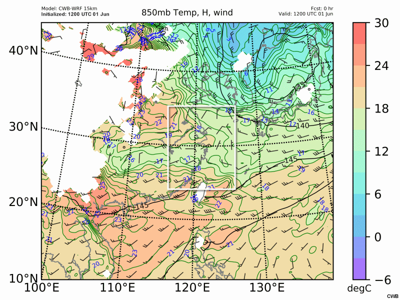
Description:
850 hPa temperature (℃, shaded), geopotential height (gpm, contour) and wind barbs (kts) from 12 UTC June 1 to 00 UTC June 2.
File Name:
2017-06-01_12_850mb_Temp.htm
Credits:
CWB
Copyright Terms:
COMET Standard Terms of Use
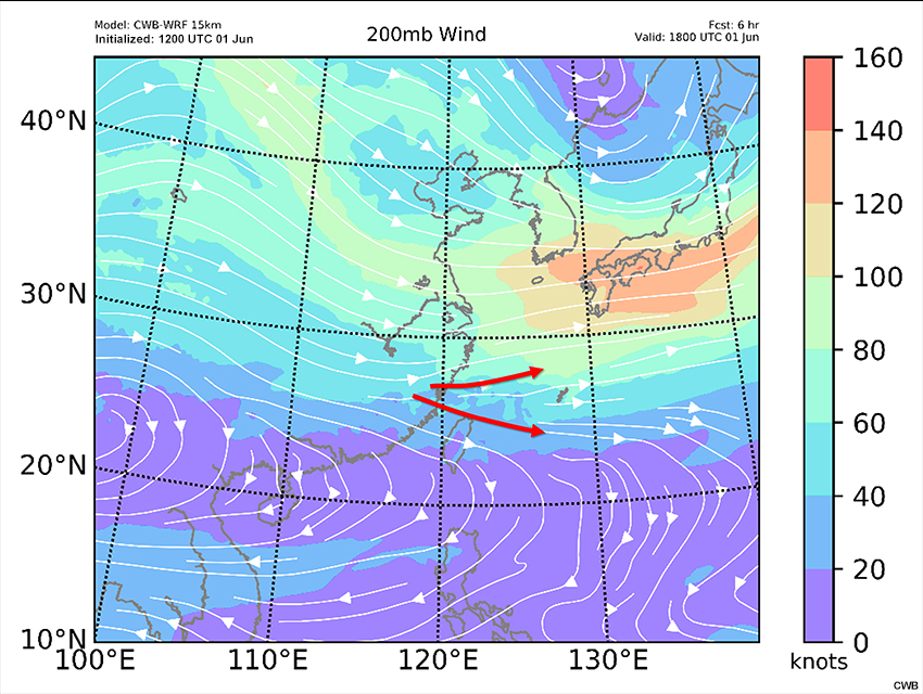
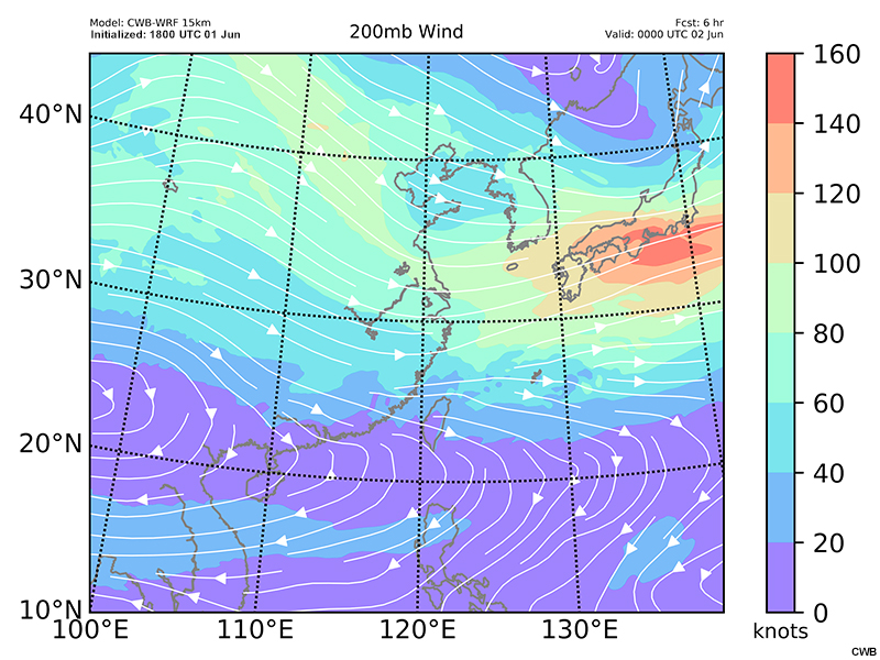
Description:
CWB-WRF model forecast of 200 hPa wind speed (kts, shaded) and streamlines valid at 18 UTC June 1 and 00 UTC June 2.
File Name:
6r_060118_200.htm
Credits:
CWB
Copyright Terms:
COMET Standard Terms of Use
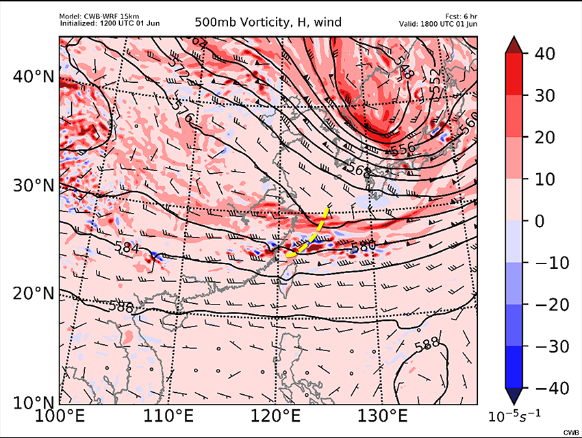
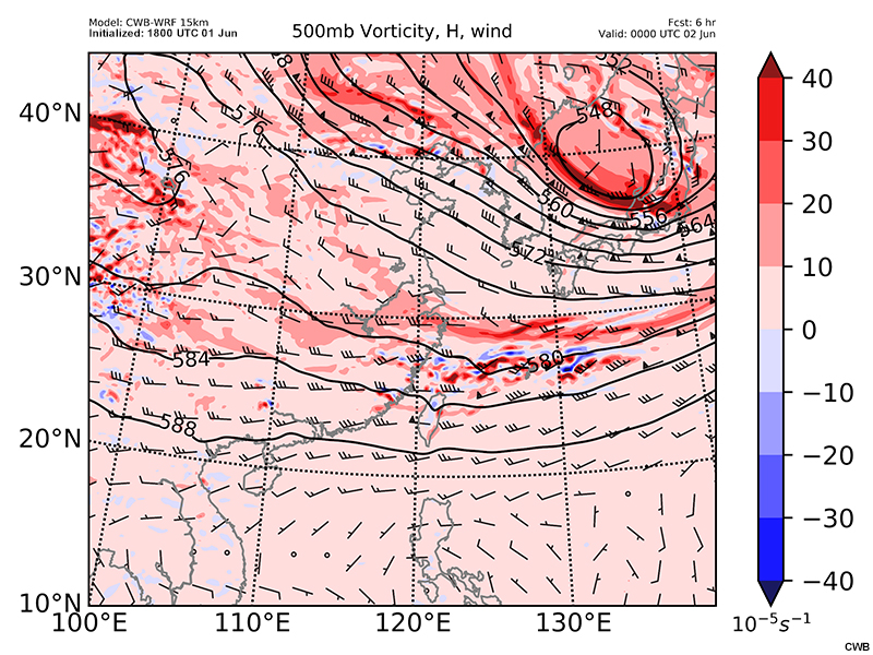
Description:
CWB-WRF model forecast of 500 hPa heights (gpm, contour), wind barbs (a full barb is 10 kts) and vorticity (10^-5s^-1, shaded) valid at 18 UTC June 1 and 00 UTC June 2.
File Name:
6r_060118_500v.htm
Credits:
CWB
Copyright Terms:
COMET Standard Terms of Use
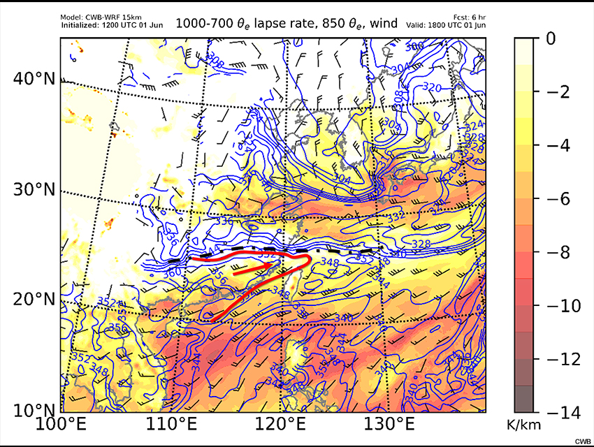
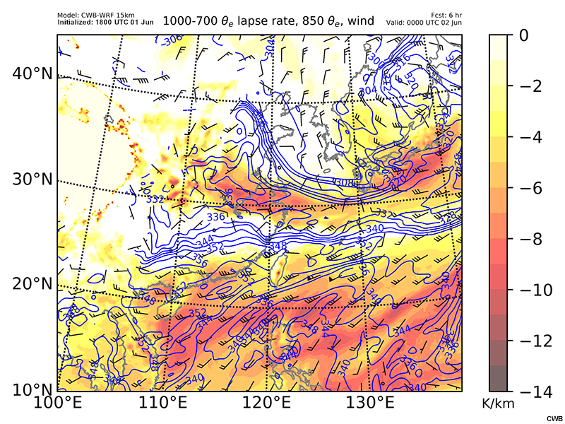
Description:
CWB-WRF model forecast of 1000-700 hPa theta-e lapse rate (shaded), 850 hPa wind barbs (a full barb is 10 kts) and theta-e (K, contour) valid at 18 UTC June 1 and 00 UTC June 2.
File Name:
6r_060118_850_theta.htm
Credits:
CWB
Copyright Terms:
COMET Standard Terms of Use
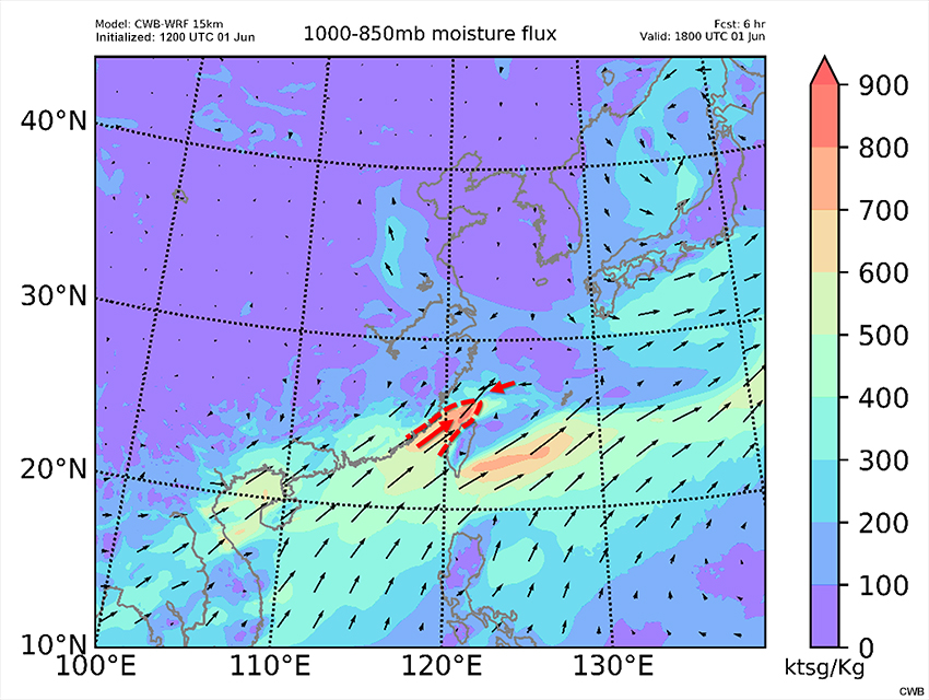
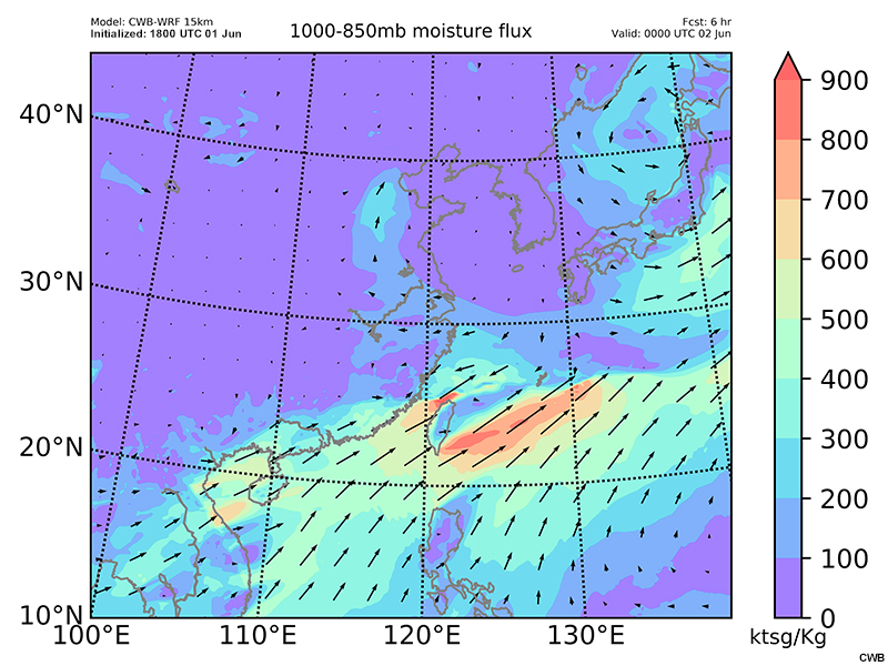
Description:
CWB-WRF model forecast of 1000-850 hPa moisture flux and moisture flux vectors (kts*g/Kg, shaded and arrows) valid at 18 UTC June 1 and 00 UTC June 2.
File Name:
6r_060118_850w.htm
Credits:
CWB
Copyright Terms:
COMET Standard Terms of Use
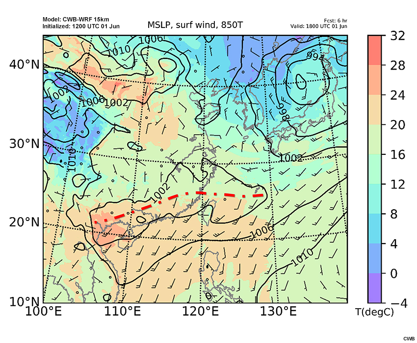
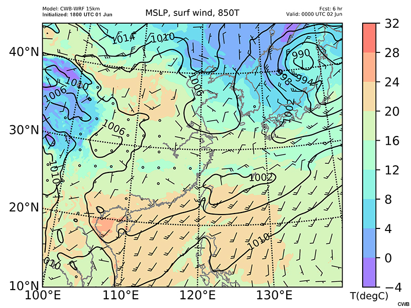
Description:
CWB-WRF model forecast of mean sea level pressure (hPa, contour), surface wind barbs (a full barb is 10 kts) and 850 hPa temperature (℃, shaded) valid at 18 UTC June 1 and 00 UTC June 2.
File Name:
6r_060118_sfc.htm
Credits:
CWB
Copyright Terms:
COMET Standard Terms of Use
Description:
CWB-WRF model forecast of 200 hPa wind speed (kts, shaded) and streamlines valid at 00 UTC June 2 and 06 UTC June 2.
File Name:
6r_060200_200.htm
Credits:
CWB
Copyright Terms:
COMET Standard Terms of Use
Description:
CWB-WRF model forecast of 500 hPa heights (gpm, contour), wind barbs (kts) and vorticity (10^-5s^-1, shaded) valid at 00 UTC June 2 and 06 UTC June 2.
File Name:
6r_060200_500v.htm
Credits:
CWB
Copyright Terms:
COMET Standard Terms of Use
Description:
CWB-WRF model forecast of 1000-700 hPa theta-e lapse rate (shaded), 850 hPa wind barbs (kts) and theta-e (K, contour) valid at 00 UTC June 2 and 06 UTC June 2.
File Name:
6r_060200_850_theta.htm
Credits:
CWB
Copyright Terms:
COMET Standard Terms of Use
Description:
CWB-WRF model forecast of 1000-850 hPa moisture flux and moisture flux vectors (kts*g/Kg, shaded and arrows) valid at 00 UTC June 2 and 06 UTC June 2.
File Name:
6r_060200_850w.htm
Credits:
CWB
Copyright Terms:
COMET Standard Terms of Use
Description:
CWB-WRF model forecast of mean sea level pressure (hPa, contour), surface wind barbs (kts) and 850 hPa temperature (℃, shaded) valid at 00 UTC June 2 and 06 UTC June 2.
File Name:
6r_060200_sfc.htm
Credits:
CWB
Copyright Terms:
COMET Standard Terms of Use
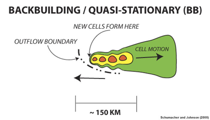
Description:
Schematic diagram of the radar-observed features of a BB MCS.
File Name:
bb_mcs.jpg
Credits:
Schumacher and Johnson (2005)
Copyright Terms:
COMET Standard Terms of Use
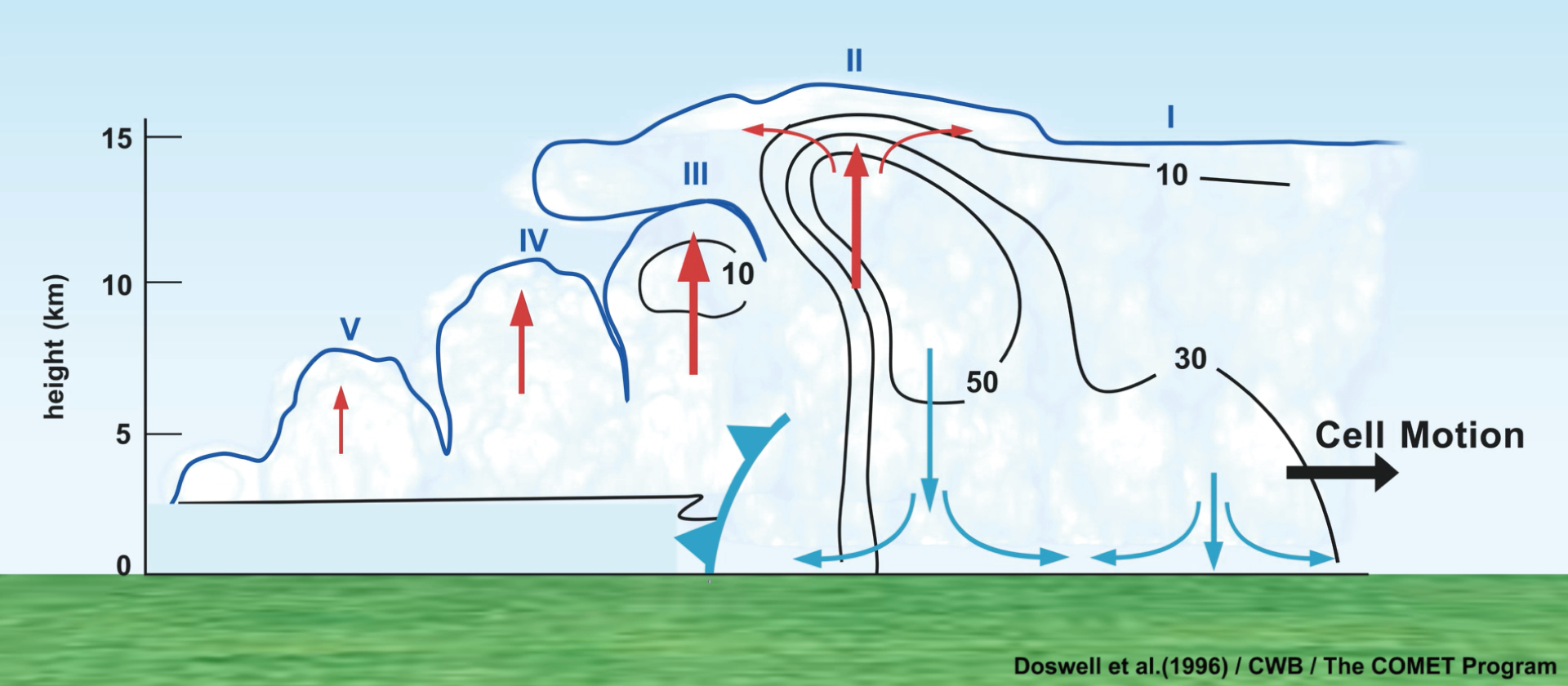
Description:
Animation showing three stages in the evolution of a multicell thunderstorm system.
File Name:
bb_test5.mp4
Credits:
Doswell et al. (1996)/CWB/The COMET Program
Copyright Terms:
COMET Standard Terms of Use
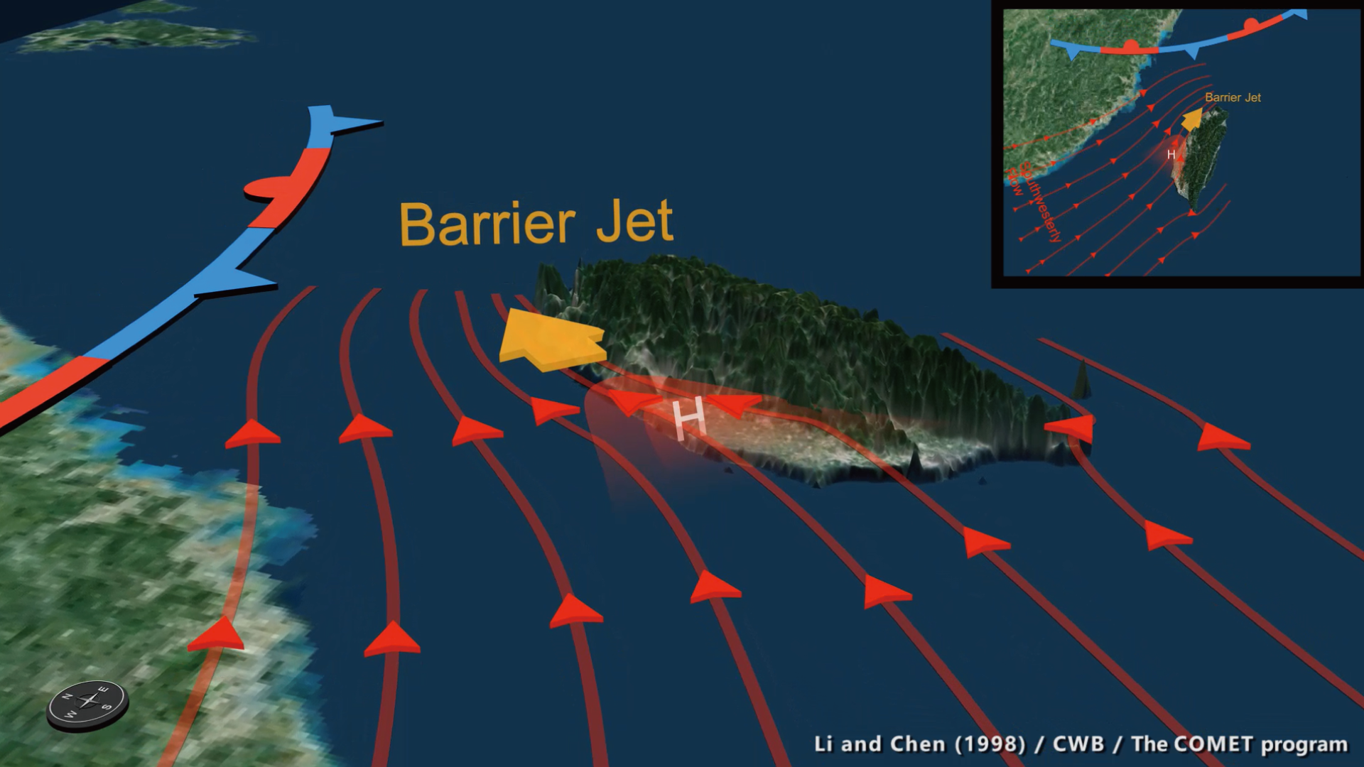
Description:
A conceptual animation showing the formation of the barrier jet.
File Name:
bbjet_12.mp4
Credits:
Li and Chen (1998)/CWB/The COMET Program
Copyright Terms:
COMET Standard Terms of Use
Description:
A blank map of Taiwan for learner QPF interaction.
File Name:
blank_qpf.jpg
Credits:
CWB
Copyright Terms:
COMET Standard Terms of Use
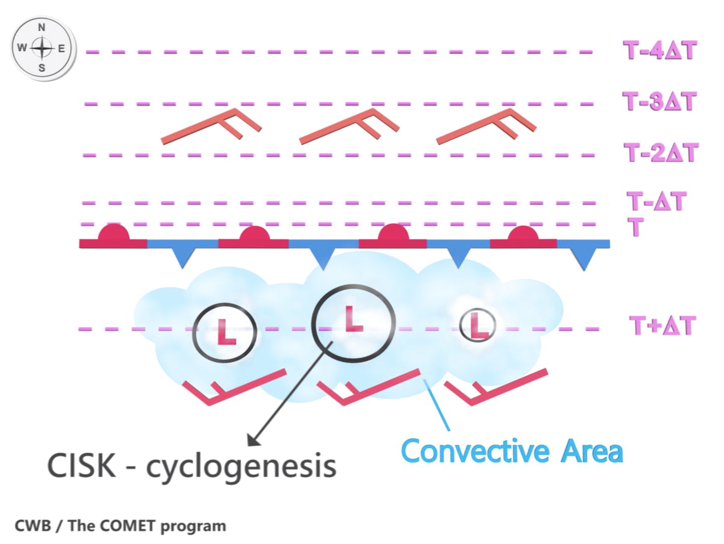
Description:
An animation (adapted from 陳, 2007) showing the roles of Mei-Yu convection, cyclogenesis, and frontogenesis in affecting the movement of the Mei-Yu front.
File Name:
CISKpart12_3.mp4
Credits:
CWB/The COMET Program
Copyright Terms:
COMET Standard Terms of Use
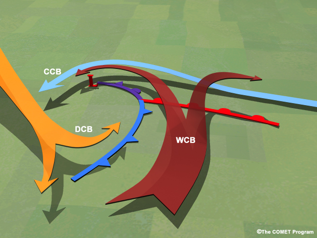
Description:
Conceptual model of conveyor belts associated with a mid-latitude cyclone.
File Name:
conveyorbelts_example.jpg
Credits:
©The COMET Program
Copyright Terms:
COMET Standard Terms of Use
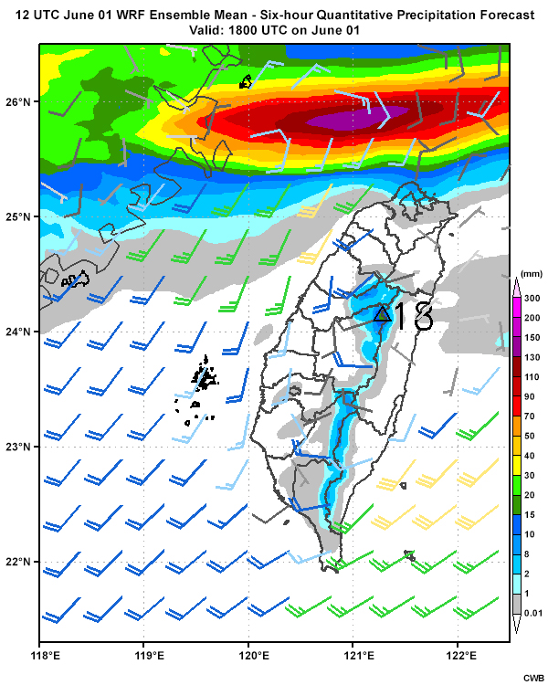
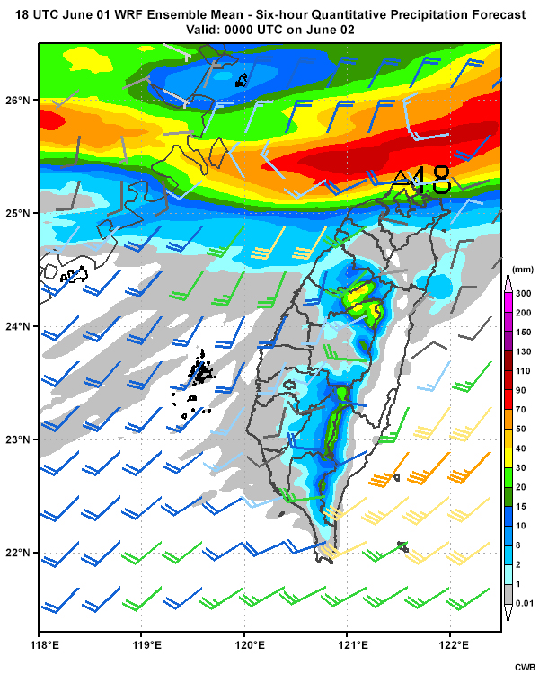
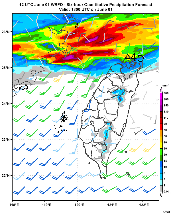
Description:
Six-hourly quantitative precipitation forecasts from the WRF Ensemble mean (initialized 12 UTC June 1) from 12 UTC June 1 through 00 UTC June 3.
File Name:
eps_12r_0601.htm
Credits:
CWB
Copyright Terms:
COMET Standard Terms of Use
Description:
Six-hourly quantitative precipitation forecasts from the WRF Ensemble mean (initialized 18 UTC June 1) from 18 UTC June 1 through 06 UTC June 3.
File Name:
eps_18r_0601.htm
Credits:
CWB
Copyright Terms:
COMET Standard Terms of Use
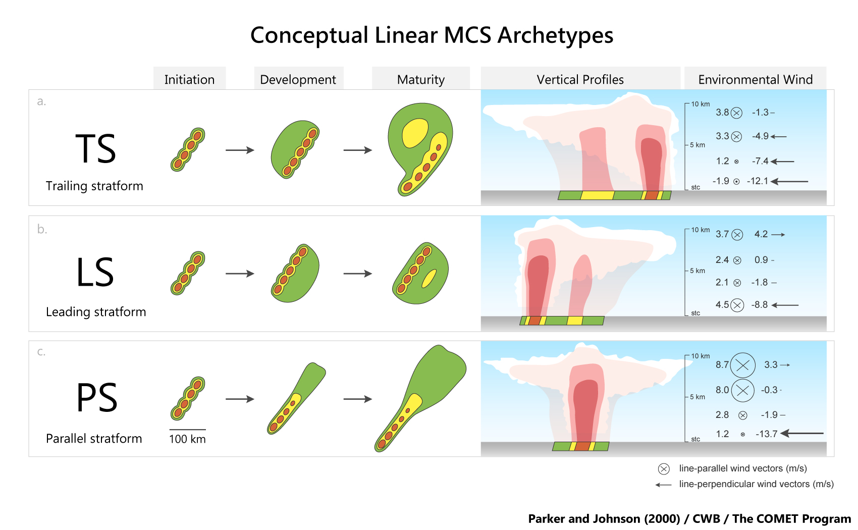
Description:
A schematic of three linear MCS archetypes described in Parker and Johnson (2000).
File Name:
MCS_3.jpg
Credits:
Parker and Johnson (2000)/CWB/The COMET Program
Copyright Terms:
COMET Standard Terms of Use
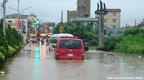
Description:
Flooding due to a Mei-Yu precipitation event on June 1, 2017.
File Name:
meiyu_flood1.jpg
Credits:
Water Resources Bureau, MOEA
Copyright Terms:
COMET Standard Terms of Use
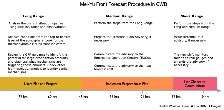
Description:
Timeline of the CWB Mei-Yu front forecast procedure during the decision-making phase of a Mei-Yu event.
File Name:
meiyu_timeline.gif
Credits:
CWB/The COMET Program
Copyright Terms:
COMET Standard Terms of Use
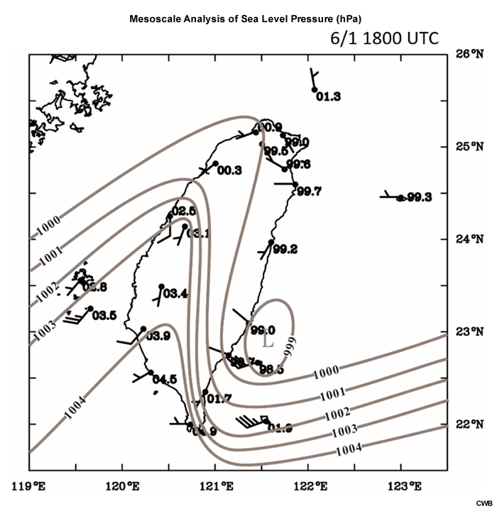
Description:
A surface analysis valid at 1800 UTC June 1.
File Name:
meso_analysis_slp.jpg
Credits:
CWB
Copyright Terms:
COMET Standard Terms of Use
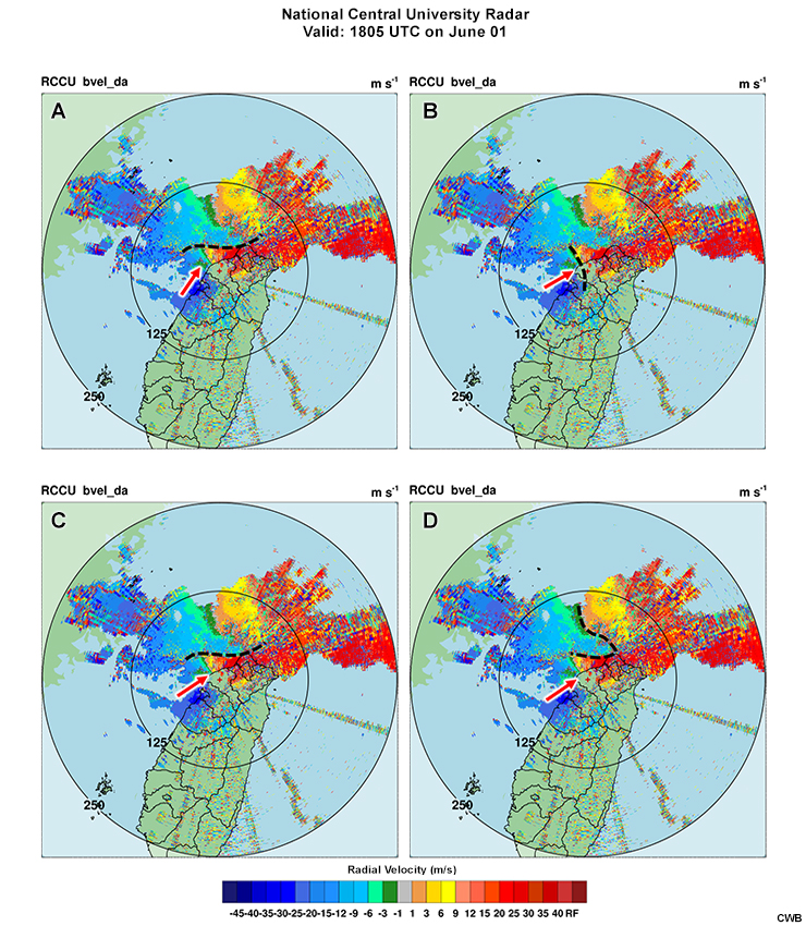
Description:
Various radar velocity analyses at 1805 UTC June 1.
File Name:
pretest_vel_draw.jpg
Credits:
CWB
Copyright Terms:
COMET Standard Terms of Use
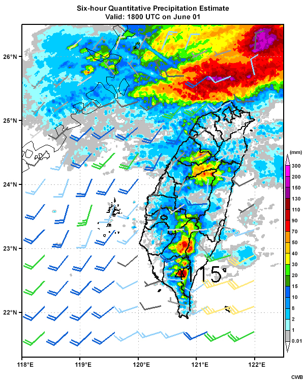
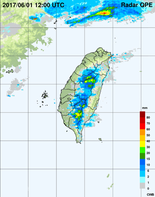
Description:
Six-hour radar-based quantitative precipitation estimate valid at 18 UTC June 1.
File Name:
qpe_6h_060118.jpg
Credits:
CWB
Copyright Terms:
COMET Standard Terms of Use
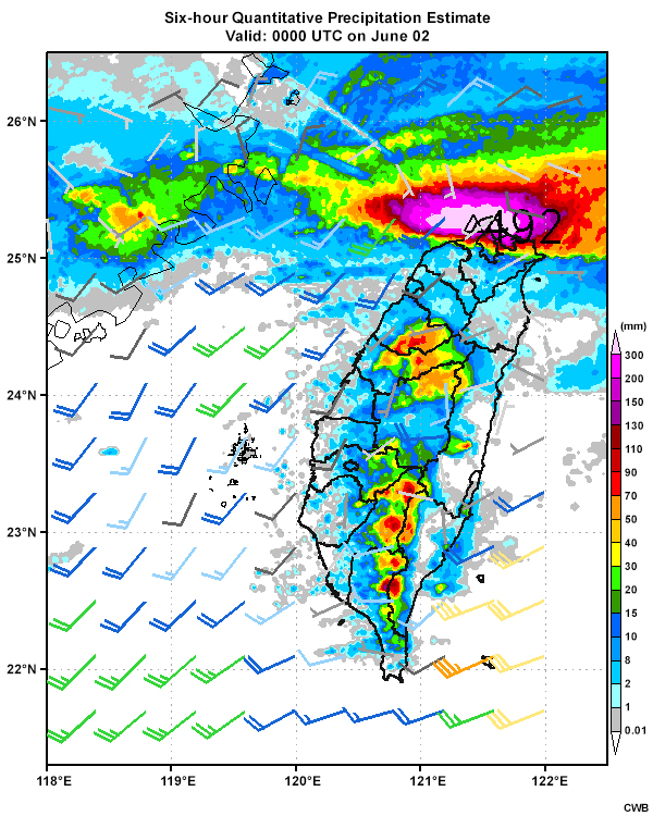
Description:
Six-hour quantitative precipitation estimate valid 00 UTC on June 2.
File Name:
qpe_6h_060200.jpg
Credits:
CWB
Copyright Terms:
COMET Standard Terms of Use
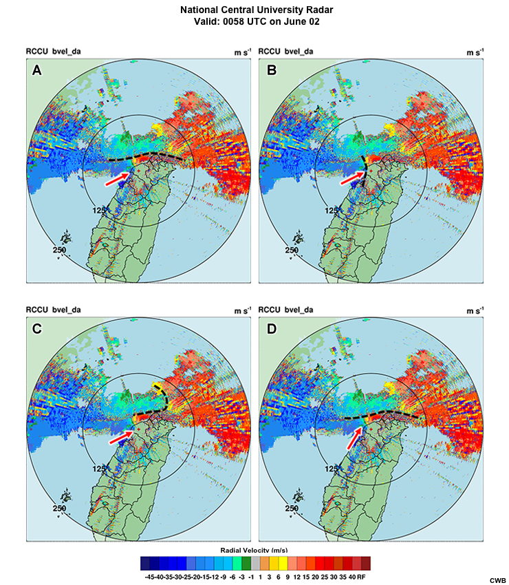
Description:
Various radar velocity analyses at 0058 UTC June 2.
File Name:
quiz_vel_draw.jpg
Credits:
CWB
Copyright Terms:
COMET Standard Terms of Use
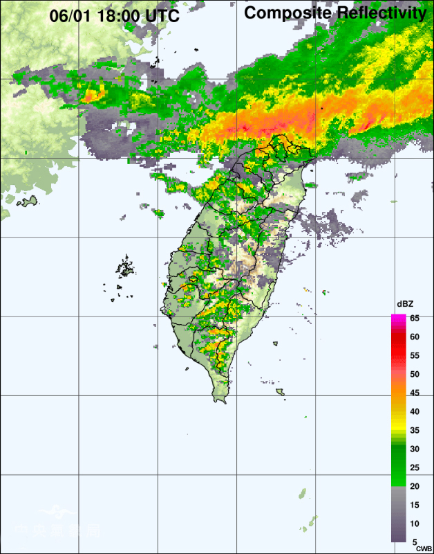
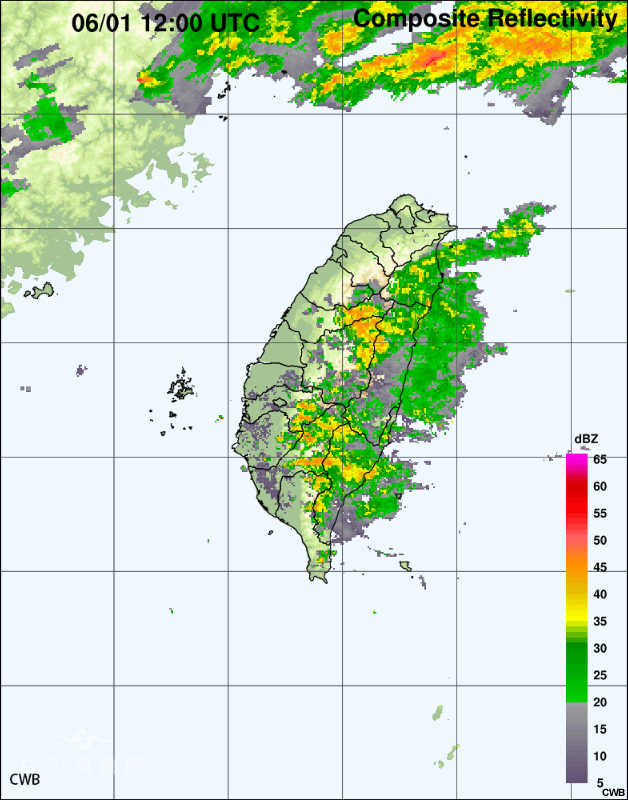
Description:
Radar reflectivity at 18 UTC on June 1.
File Name:
radar_060118.jpg
Credits:
CWB
Copyright Terms:
COMET Standard Terms of Use
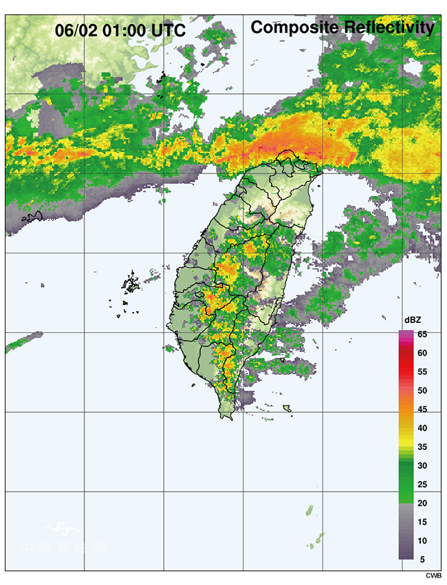
Description:
Radar reflectivity at 01 UTC on June 2.
File Name:
radar_060201.jpg
Credits:
CWB
Copyright Terms:
COMET Standard Terms of Use
Description:
Radar reflectivity loop (every 10 minutes) from 12 UTC to 18 UTC June 1.
File Name:
radar_20170601_12-18.htm
Credits:
CWB
Copyright Terms:
COMET Standard Terms of Use
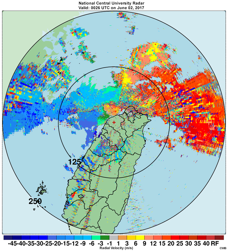
Description:
Radial velocities (0.5 degree) across the North Area of Taiwan from the National Central University (CU) radar at 0026 UTC June 2.
File Name:
radar_vel_20170602_01.jpg
Credits:
CWB
Copyright Terms:
COMET Standard Terms of Use
Description:
Radar-based 1-hour accumulated quantitative precipitation estimates (every 10 minutes) from 12 UTC June 1 to 00 UTC June 2.
File Name:
radarqpe_060112-060206.mp4
Credits:
CWB
Copyright Terms:
COMET Standard Terms of Use
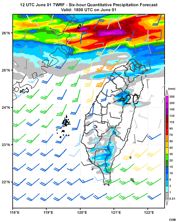
Description:
Six-hourly quantitative precipitation forecasts from the TWRF model (initialized 12 UTC June 1) from 12 UTC June 1 through 00 UTC June 3.
File Name:
twrf_12r_0601.htm
Credits:
CWB
Copyright Terms:
COMET Standard Terms of Use
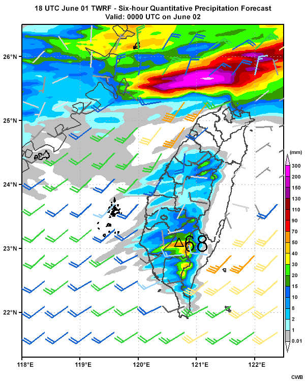
Description:
Six-hourly quantitative precipitation forecasts from the TWRF model (initialized 18 UTC June 1) from 18 UTC June 1 through 06 UTC June 3.
File Name:
twrf_18r_0601.htm
Credits:
CWB
Copyright Terms:
COMET Standard Terms of Use
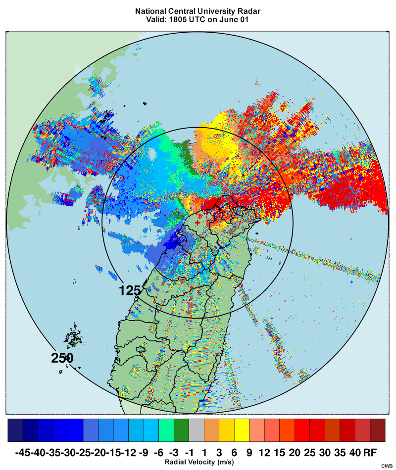
Description:
Radial velocities (0.5 degree) across the North Area of Taiwan from the National Central University (CU) radar at 1805 UTC June 1.
File Name:
vel_0601_1805.jpg
Credits:
CWB
Copyright Terms:
COMET Standard Terms of Use
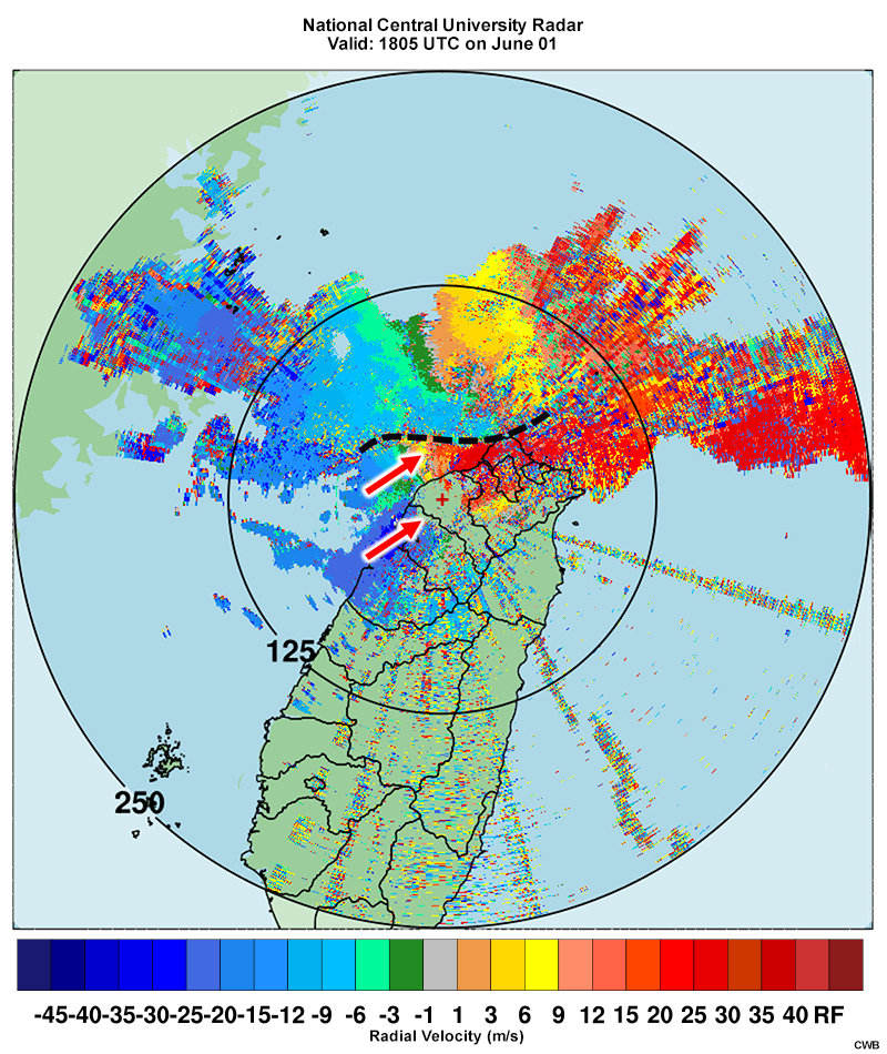
Description:
Radial velocities (0.5 degree) across the North Area of Taiwan with convergence line (black dashed-line) and barrier jet (red arrows).
File Name:
vel_0601_1805_feedback.jpg
Credits:
CWB
Copyright Terms:
COMET Standard Terms of Use
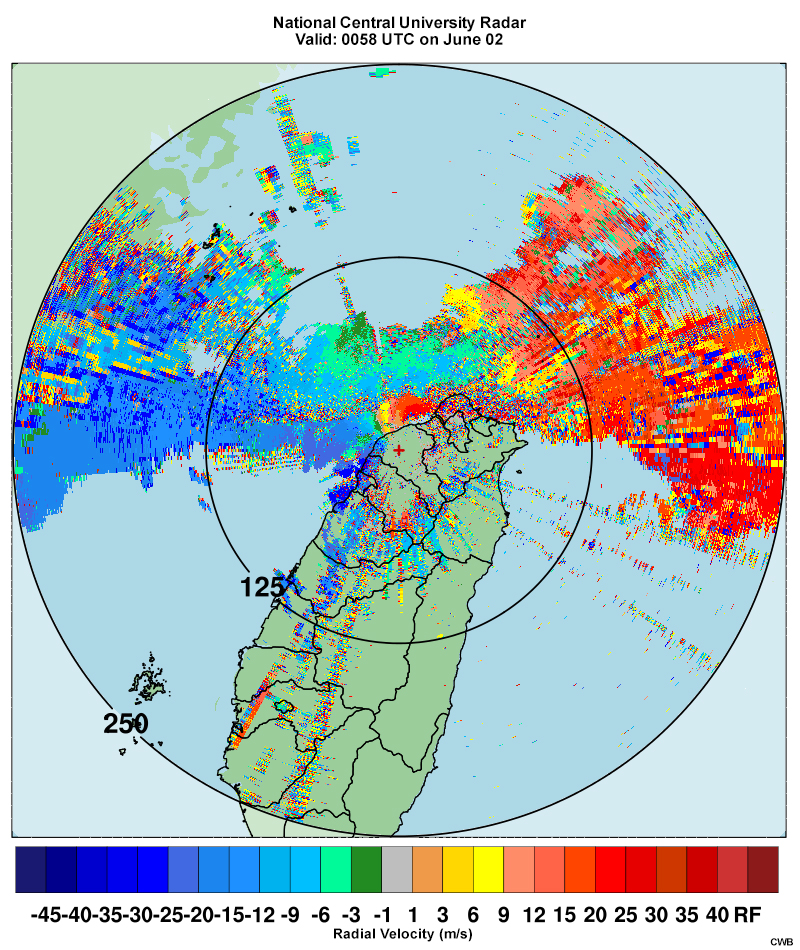
Description:
Radial velocities (0.5 degree) across the North Area of Taiwan from the National Central University (CU) radar at 0058 UTC on June 2. Radial velocities in blue indicate flow moving towards the radar, and radial velocities in red indicate flow moving away from the radar.
File Name:
vel_0602_0058.jpg
Credits:
CWB
Copyright Terms:
COMET Standard Terms of Use

Description:
A video of how water vapor imagery is made from the perspective of the satellite.
File Name:
water_vapor_construction.mp4
Credits:
NOAA/The COMET Program
Copyright Terms:
COMET Standard Terms of Use
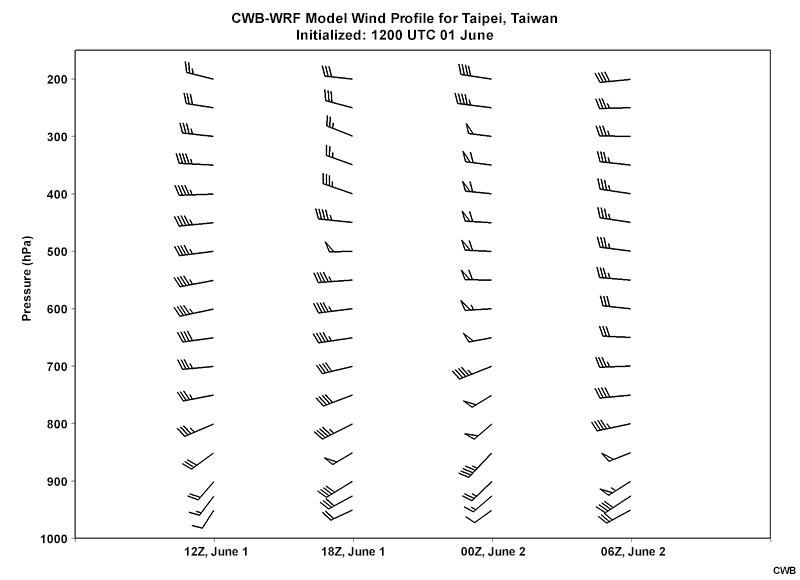
Description:
Time-height cross section of the CWB-WRF model forecast wind (a full barb is 10 kts) at the Taipei station from 06 UTC June 1 to 06 UTC June 2.
File Name:
wind_taipei_init0601_12z.jpg
Credits:
CWB
Copyright Terms:
COMET Standard Terms of Use
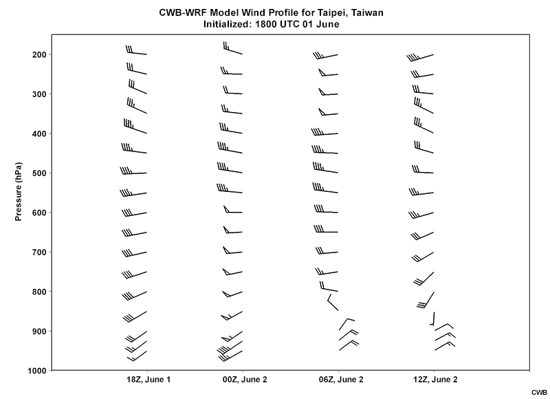
Description:
Time-height cross section of the CWB-WRF model forecast wind (a full barb is 10 kts) at the Taipei station from 18 UTC June 1 to 12 UTC June 2.
File Name:
wind_taipei_init0601_18z.jpg
Credits:
CWB
Copyright Terms:
COMET Standard Terms of Use
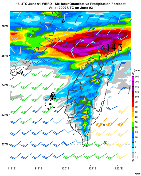
Description:
Six-hourly quantitative precipitation forecasts from the WRFD model (initialized 12 UTC June 1) from 12 UTC June 1 through 00 UTC June 3.
File Name:
wrfd_12r_0601.htm
Credits:
CWB
Copyright Terms:
COMET Standard Terms of Use
Description:
Six-hourly quantitative precipitation forecasts from the WRFD model (initialized 18 UTC June 1) from 18 UTC June 1 through 06 UTC June 3.
File Name:
wrfd_18r_0601.htm
Credits:
CWB
Copyright Terms:
COMET Standard Terms of Use
Description:
A water vapor satellite loop from 12 UTC to 18 UTC June 1.
File Name:
wv_0601_12-18.htm
Credits:
Meteorological Satellite Center of Japan Meteorological Agency/CWB
Copyright Terms:
COMET Standard Terms of Use

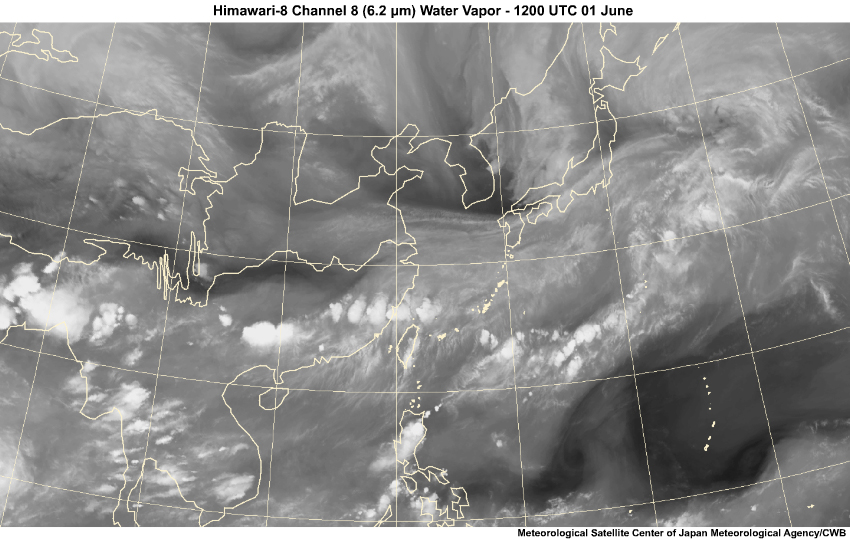
Description:
A water vapor satellite image valid at 18 UTC June 1 for trough, DCB and WCB identification.
File Name:
wv_060118.jpg
Credits:
Meteorological Satellite Center of Japan Meteorological Agency/CWB
Copyright Terms:
COMET Standard Terms of Use

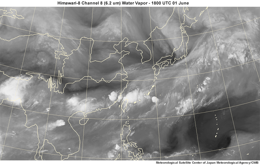
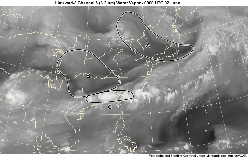
Description:
A water vapor satellite image valid at 18 UTC June 1 with areas of interest outlined.
File Name:
wv_060118_areas.jpg
Credits:
Meteorological Satellite Center of Japan Meteorological Agency/CWB
Copyright Terms:
COMET Standard Terms of Use
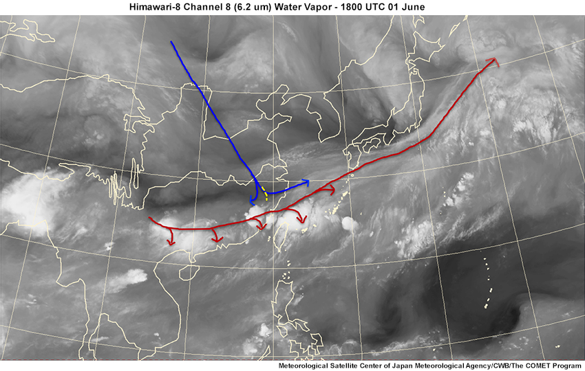
Description:
A water vapor satellite image valid at 18 UTC June 1 with trough, DCB and WCB annotations.
File Name:
wv_060118_feedback.jpg
Credits:
Meteorological Satellite Center of Japan Meteorological Agency/CWB/The COMET Program
Copyright Terms:
COMET Standard Terms of Use
Description:
A water vapor satellite loop from 18 UTC June 1 to 00 UTC on June 2.
File Name:
wv_060118-060200.htm
Credits:
Meteorological Satellite Center of Japan Meteorological Agency/CWB
Copyright Terms:
COMET Standard Terms of Use
Description:
A water vapor satellite image valid at 00 UTC on June 2 with areas of interest outlined.
File Name:
wv_060200_areas.jpg
Credits:
Meteorological Satellite Center of Japan Meteorological Agency/CWB
Copyright Terms:
COMET Standard Terms of Use