Introduction
You work for an NWS coastal office and your mentor Karine asked you to review the events surrounding Hurricane Sandy from the 2012 Atlantic hurricane season. After reviewing archived products and news stories about the hurricane, you meet with Karine to discuss it.
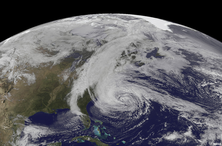
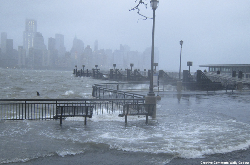
“Hurricane Sandy was a storm to remember. It packed 70-kt maximum sustained winds when it made landfall as a post-tropical system. And because of its tremendous size, Sandy drove catastrophic storm surge into the coastlines. There were about 150 fatalities and $50 billion in damage. It is hard to believe what I am reading.”
“It was an impressive and challenging storm to deal with,” Karine agrees. “Not only did we expect the hurricane to affect a large area with a variety of hazards, but it was also forecast to lose its tropical characteristics and evolve into a post-tropical cyclone at some point before landfall.”
After a brief pause, Karine continues. “In the past, the NHC used to discontinue advisories whenever a tropical cyclone became extratropical, or no longer possessed characteristics to be classified as a tropical cyclone. When that happened, tropical watches and warnings were discontinued since they were tied to the NHC advisory products.”
“Wait, that would explain why there was conflicting information about the severity of potential impacts from Sandy ahead of the storm,” you say, nodding your head. “There were reports about why hurricane watches and warnings were not issued. That caused confusion and disruption for emergency managers trying to prepare and evacuate coastal residents in advance of the storm.”
“That is precisely why I asked you to review the Hurricane Sandy case,” Karine says, shuffling some papers on her desk. “Sandy uncovered this communication weakness in the NWS tropical watch/warning program. It became apparent that there needed to be a way for the NWS to issue and maintain tropical watches and warnings for systems transitioning from tropical to extratropical. Now, the NHC and NWS have the option to issue and maintain tropical watches and warnings during the transition phase.”
“Sounds like that was a major step towards improving how we communicate our forecast and warning information to the public,” you respond.
“Yes, with this policy change, we can work on improving our collaboration and decision-making processes on product issuance and public weather communications as a tropical cyclone transitions to extratropical,” she continues. “We want forecasters to focus on hazards and impacts, to collaborate with NHC and neighboring offices, and provide consistent messaging to our partners before, during, and after the transition takes place.”
“It would be great if I can practice issuing products and communicating information using the new policy with a transitioning cyclone,” you say, thinking aloud.
“Great! That is exactly what the next exercise is about,” says Karine.
Simulation
Clicking the button below will open a new tab where you will begin the simulation.
Summary
As you have seen in this lesson, the flexibility of the NWS in its operations after Hurricane Sandy enables national centers, forecast offices and regional operation centers to become more effective in their messaging of extratropical transitioning tropical cyclones. Preparing messages focused on hazards and impacts, collaborating with NHC and neighboring offices, and providing consistent messaging to our partners before, during, and after the transition takes place can be very helpful.
It is good to use the following practices when messaging hazards during an extratropical transition event:
- Focus the message on the imminent threats and impacts of the storm, not on the specific characteristics of the storm.
- Coordinate the message of threats and impacts among neighboring offices and operation centers as the storm evolves, despite the type of product being used (tropical vs. non-tropical).
- Maintain a consistent message about the threats and impacts of the storm, especially when the storm undergoes extratropical transition.
- Collaborate with local emergency managers to help communicate key talking points to politicians and media personnel.
Contributors
COMET Sponsors
MetEd and the COMET® Program are a part of the University Corporation for Atmospheric Research's (UCAR's) Community Programs (UCP) and are sponsored by
- NOAA's National Weather Service
(NWS)
with additional funding by: - Bureau of Meteorology of Australia (BoM)
- Bureau of Reclamation, United States Department of the Interior
- European Organisation for the Exploitation of Meteorological Satellites (EUMETSAT)
- Meteorological Service of Canada (MSC)
- NOAA National Environmental Satellite, Data and Information Service (NESDIS)
- NOAA's National Geodetic Survey (NGS)
- National Science Foundation (NSF)
- Naval Meteorology and Oceanography Command (NMOC)
- U.S. Army Corps of Engineers (USACE)
- World Meteorological Organization (WMO)
To learn more about us, please visit the COMET website.
Project Contributors
Project Lead
- Tsvetomir Ross-Lazarov — UCAR/COMET
- Vanessa Vincente — UCAR/COMET
Instructional Design
- Tsvetomir Ross-Lazarov — UCAR/COMET
Science Advisors
- Frank Alsheimer - Science and Operations Officer, NOAA National Weather Service Columbia, SC
- Daniel Brown - Senior Hurricane Specialist/Warning Coordination Meteorologist, National Weather Service, National Hurricane Center
- Joel Cline - Tropical Program Coordinator, NOAA National Weather Service
- John Koch - Warning Coordination Meteorologist Program Manager, NWS Eastern Region
- Danielle Manning - Forecaster, National Weather Service New Orleans/Baton Rouge, LA
- Pablo Santos - Meteorologist In Charge, National Weather Service Miami, FL
- Andrew Zimmerman - Forecaster, National Weather Service Wakefield, VA
Program Oversight
- Tsvetomir Ross-Lazarov — UCAR/COMET
Graphics/Animations
- Steve Deyo — UCAR/COMET
Multimedia Authoring/Interface Design
- Gary Pacheco — UCAR/COMET
COMET Staff, September 2021
Director's Office
- Dr. Elizabeth Mulvihill Page, Director
- Tim Alberta, Assistant Director Operations and IT
- Dr. Paul Kucera, Assistant Director International Programs
- Dr. Wendy Gram, Implementation Manager
Business Administration
- Lorrie Alberta, Administrator
- Tara Torres, Program Coordinator
IT Services
- Bob Bubon, Systems Administrator
- Joey Rener, Software Engineer
- Malte Winkler, Software Engineer
Instructional Services
- Dr. Alan Bol, Instructional Designer/Scientist
- Tony Mancus, Instructional Designer
- Sarah Ross-Lazarov, Instructional Designer
- Tsvetomir Ross-Lazarov, Instructional Designer
International Programs
- David Russi, Translations Coordinator
- Martin Steinson, Project Manager
Production and Media Services
- Steve Deyo, Graphic and 3D Designer
- Dolores Kiessling, Software Engineer
- Gary Pacheco, Web Designer and Developer
- Tyler Winstead, Web Developer
Science Group
- Patrick Dills, Meteorologist
- Bryan Guarente, Instructional Designer/Meteorologist
- Adam Hirsch, Meteorologist
- Matthew Kelsch, Hydrometeorologist
- Brianna Lund, Meteorologist
- Andrea Smith, Meteorologist
- Amy Stevermer, Scientist/Instructional Designer
- Vanessa Vincente, Meteorologist