SatFC-J: Satellite Foundational Course for JPSS
The VIIRS Imager
Media elements used in this module are protected by a variety of copyright licenses. Please use the "copyright terms" link associated with each item below for more information.
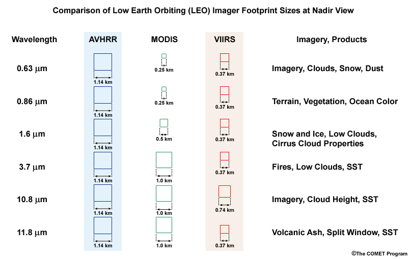
Description:
Comparison of footprint sizes at nadir view for LEO meteorological imagers including NOAA AVHRR, Terra and Aqua MODIS, and Suomi-NPP and JPSS VIIRS
File Name:
avhrr_modis_viirs_fov_res_table.jpg
Credits:
©The COMET Program
Copyright Terms:
COMET Standard Terms of Use
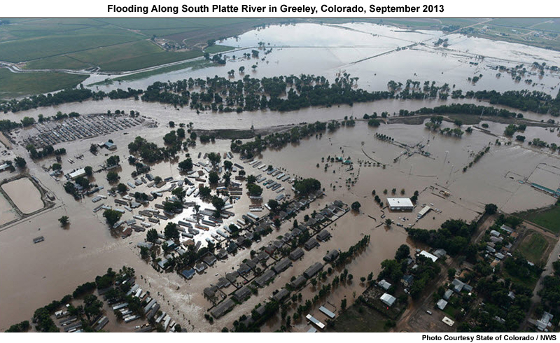
Description:
Photo of flooding along the South Platte River in Greeley, Colorado in September 2013 following record rainfall along the northern Front Range mountains in northeastern Colorado.
File Name:
co_platte_river_flooding_sep2013.jpg
Credits:
Photo Courtesy State of Colorado / NWS
Copyright Terms:
COMET Standard Terms of Use
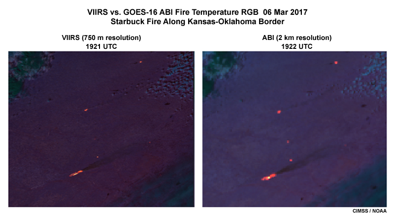
Description:
Suomi-NPP VIIRS vs. GOES-16 ABI fire temperature RGB images showing the Starbuck fire along the Kansas-Oklahoma border on March 6, 2017
File Name:
fire_temp_viirs_vs_abi.jpg
Credits:
CIMSS / NOAA
Copyright Terms:
COMET Standard Terms of Use
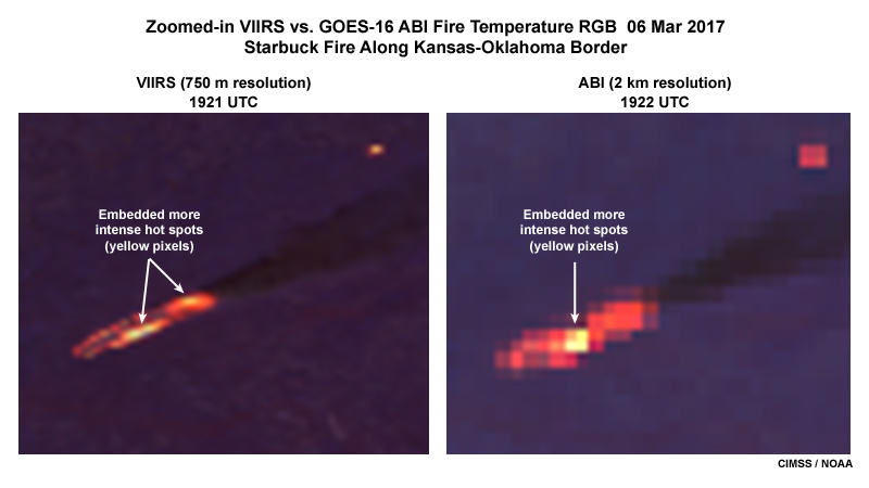
Description:
Suomi-NPP VIIRS vs. GOES-16 ABI zoomed-in fire temperature RGB images showing the Starbuck fire along the Kansas-Oklahoma border on March 6, 2017
File Name:
fire_temp_viirs_vs_abi_zoom.jpg
Credits:
CIMSS / NOAA
Copyright Terms:
COMET Standard Terms of Use
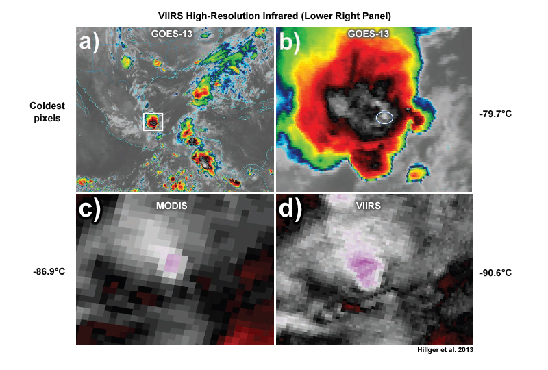
Description:
Cloud tops associated with deep convection as seen by (a) GOES-13 10.7 μm IR, (b) zoomed-in GOES-13 10.7 μm IR, (c) MODIS 11.0 μm IR, and (d) VIIRS 11.45 μm IR, at around 0815 UTC, June 6, 2012. An extreme close-up covering the blue circled region (seen in the GOES-13 image (b)) from MODIS is shown in (c), and a similar close-up from VIIRS is shown in (d).
File Name:
goes_modis_viirs_conv_cldtops_05jun12.jpg
Credits:
Hillger et al. 2013
Copyright Terms:
COMET Standard Terms of Use
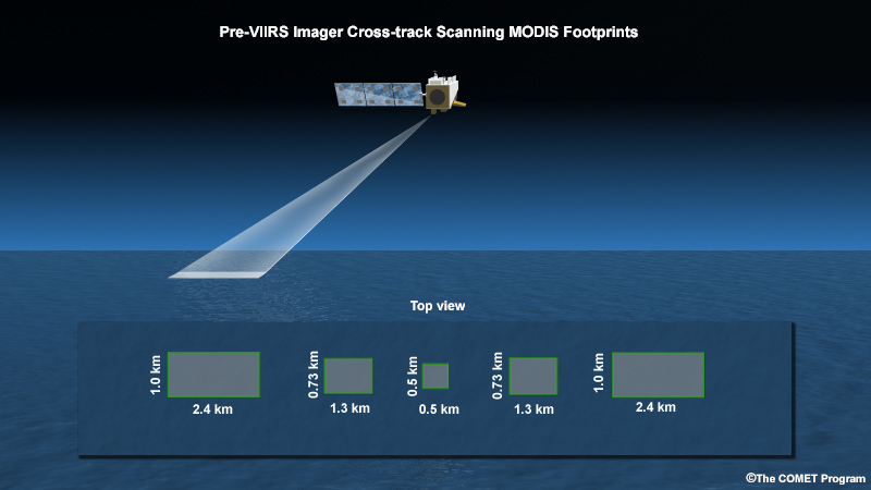
Description:
Animation showing conventional low Earth orbiting imager cross-track scanning geometry with footprints growing from nadir view to the edge of scan
File Name:
imager_crosstrack_scanning.mp4
Credits:
©The COMET Program
Copyright Terms:
COMET Standard Terms of Use
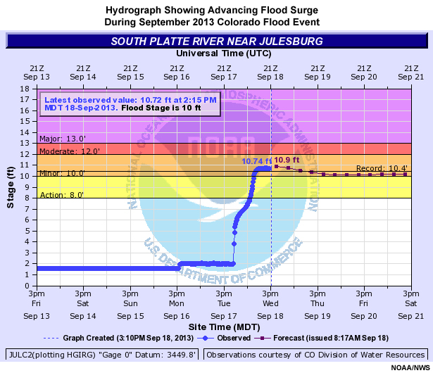
Description:
Hydrograph showing advancing flood surge during September 2013 Colorado flood event, from 13 to 21 September, 2013
File Name:
julesburg_CO_hydrograph_18sep13.jpg
Credits:
NOAA/NWS
Copyright Terms:
COMET Standard Terms of Use
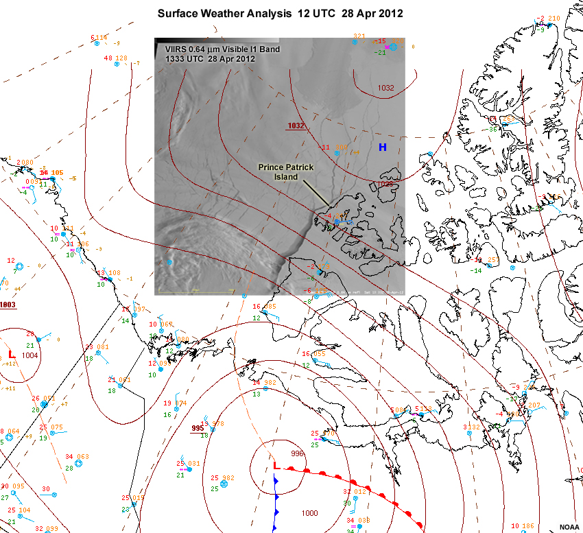
Description:
NOAA generated surface weather analysis over the Canadian Arctic Archipelago with VIIRS visible image inset for conditions between 12 to 1333 UTC on April 28, 2012
File Name:
namsfc_20120428_12utc_viirs_vis.jpg
Credits:
NOAA
Copyright Terms:
COMET Standard Terms of Use
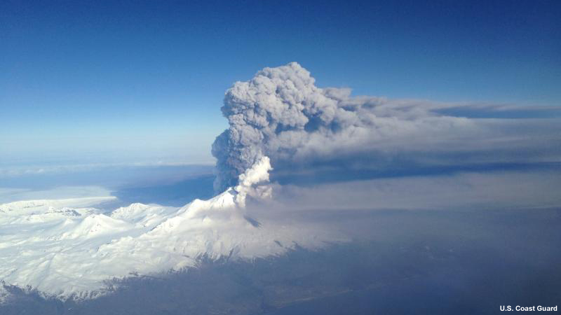
Description:
Alaska’s Pavlof Volcano erupted on March 27, 2016, spewing a 20,000 foot high ash plume
File Name:
pavlof_eruption_27mar16.jpg
Credits:
U.S. Coast Guard
Copyright Terms:
COMET Standard Terms of Use
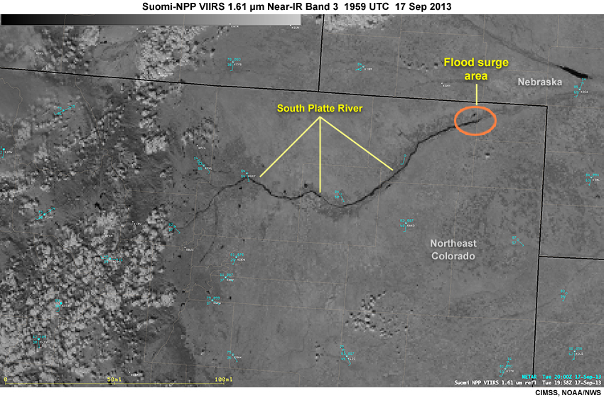
Description:
Suomi NPP VIIRS 1.61 near-infrared band 2 image over northeastern Colorado during the September 2013 flood event, showing the Platte River flood surge as it moves eastward, 2000 UTC, September 17, 2013
File Name:
snpp_viirs_16nir_co_fldg_17sep13.jpg
Credits:
CIMSS, NOAA/NWS
Copyright Terms:
COMET Standard Terms of Use
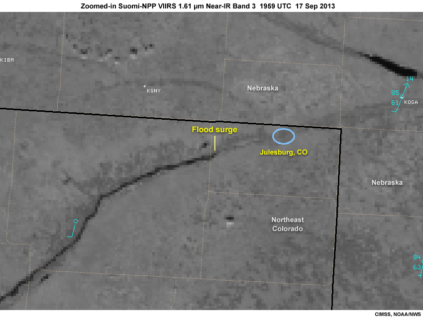
Description:
Zoomed-in Suomi NPP VIIRS 1.61 near-infrared band 2 image over northeastern Colorado during the September 2013 flood event, showing the Platte River flood surge as it moves eastward, 2000 UTC, September 17, 2013
File Name:
snpp_viirs_16nir_zoom_co_fldg_17sep13.jpg
Credits:
CIMSS, NOAA/NWS
Copyright Terms:
COMET Standard Terms of Use
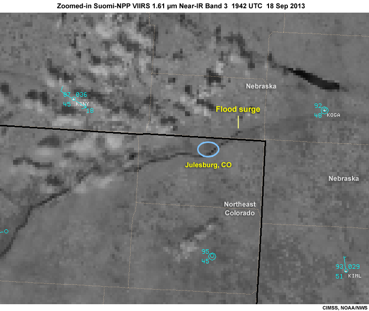
Description:
Zoomed-in Suomi NPP VIIRS 1.61 near-infrared band 2 image over northeastern Colorado during the September 2013 flood event, showing the Platte River flood surge as it moves eastward, 1942 UTC, September 18, 2013
File Name:
snpp_viirs_16nir_zoom_co_fldg_18sep13.jpg
Credits:
CIMSS, NOAA/NWS
Copyright Terms:
COMET Standard Terms of Use
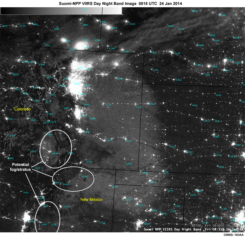
Description:
Suomi-NPP VIIRS Day Night Band image showing fog and stratus over southern Colorado and northern New Mexico at 0815 UTC on January 24, 2014
File Name:
snpp_viirs_dnb_24jan14.jpg
Credits:
CIMSS / NOAA
Copyright Terms:
COMET Standard Terms of Use
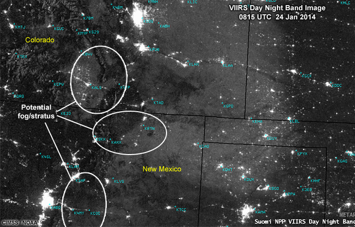
Description:
Suomi-NPP VIIRS Day Night Band image showing fog and stratus over southern Colorado and northern New Mexico at 0815 UTC on January 24, 2014
File Name:
snpp_viirs_dnb_24jan14_crop.jpg
Credits:
CIMSS / NOAA
Copyright Terms:
COMET Standard Terms of Use
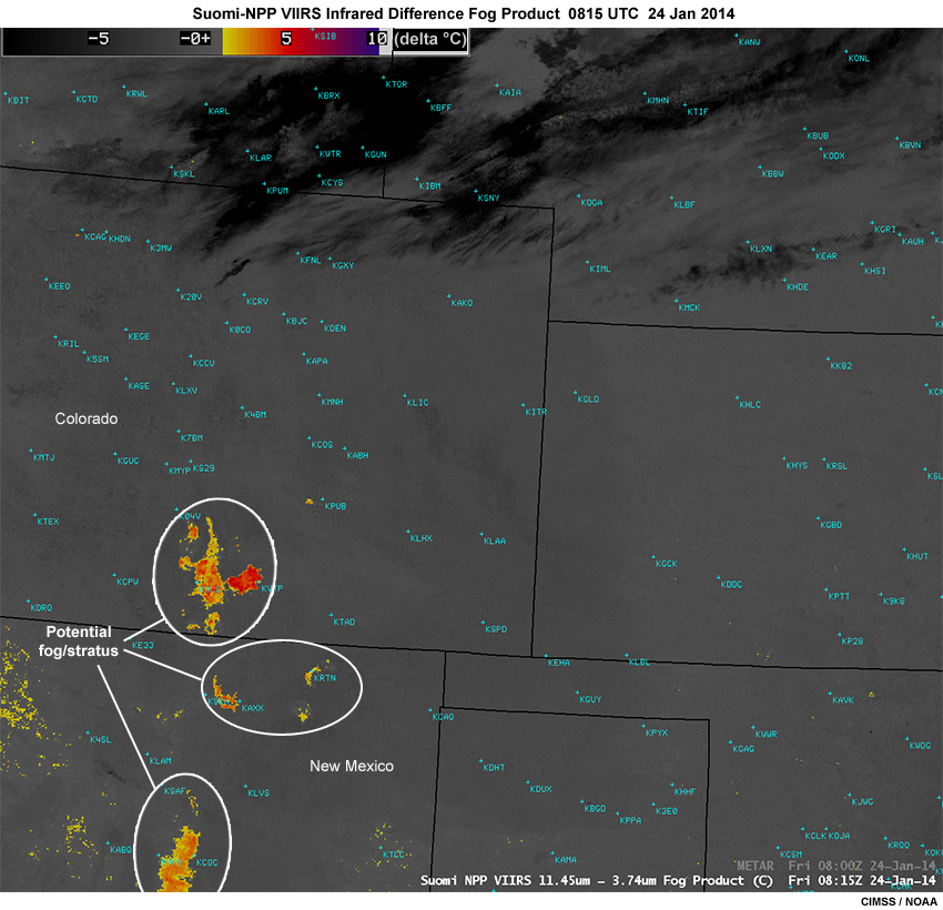
Description:
Suomi-NPP VIIRS infrared fog product showing nighttime fog and stratus over southern Colorado and northern New Mexico at 0815 UTC on January 24, 2014
File Name:
snpp_viirs_ir_fogprod_24jan14.jpg
Credits:
CIMSS / NOAA
Copyright Terms:
COMET Standard Terms of Use
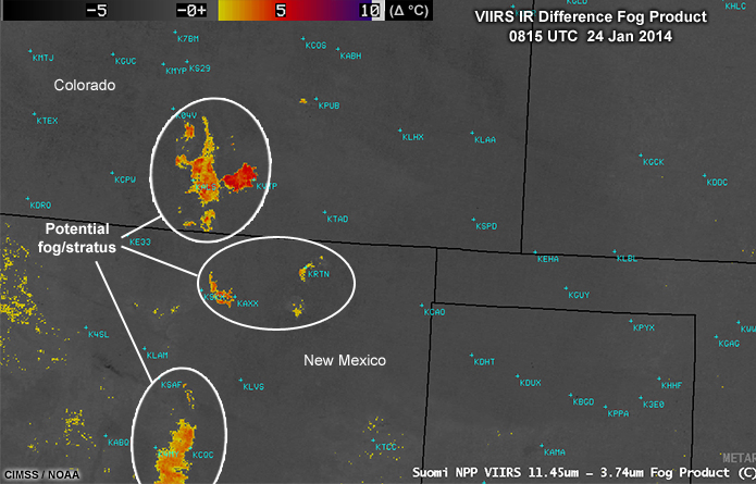
Description:
Suomi-NPP VIIRS infrared fog product showing nighttime fog and stratus over southern Colorado and northern New Mexico at 0815 UTC on January 24, 2014
File Name:
snpp_viirs_ir_fogprod_24jan14_crop.jpg
Credits:
CIMSS / NOAA
Copyright Terms:
COMET Standard Terms of Use
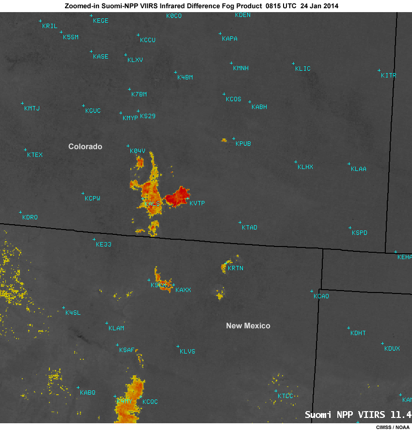
Description:
Zoomed-in Suomi-NPP VIIRS infrared fog product showing nighttime fog and stratus over southern Colorado and northern New Mexico at 0815 UTC on January 24, 2014
File Name:
snpp_viirs_ir_fogprod_zoom_24jan14.jpg
Credits:
CIMSS / NOAA
Copyright Terms:
COMET Standard Terms of Use
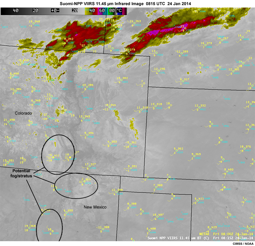
Description:
Suomi-NPP VIIRS 11.45 micrometer infrared image showing fog and stratus over southern Colorado and northern New Mexico at 0815 UTC on January 24, 2014
File Name:
snpp_viirs_ir_obs_24jan14.jpg
Credits:
CIMSS / NOAA
Copyright Terms:
COMET Standard Terms of Use
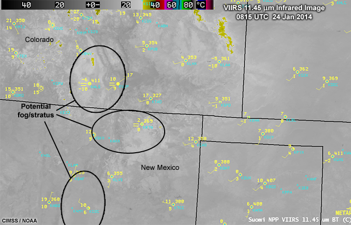
Description:
Suomi-NPP VIIRS 11.45 micrometer infrared image showing fog and stratus over southern Colorado and northern New Mexico at 0815 UTC on January 24, 2014
File Name:
snpp_viirs_ir_obs_24jan14_crop.jpg
Credits:
CIMSS / NOAA
Copyright Terms:
COMET Standard Terms of Use
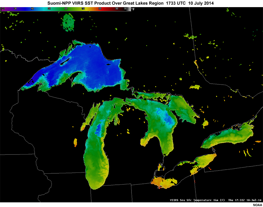
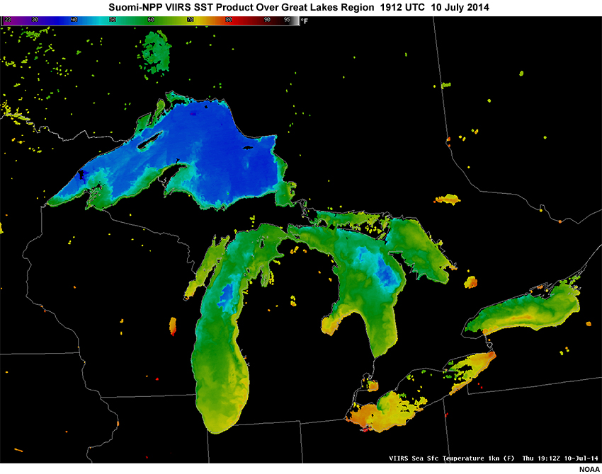
Description:
Suomi NPP VIIRS SST derived product over the Great Lakes on July 10, 2014
File Name:
snpp_viirs_sst_10jul14_01.jpg
Credits:
NOAA
Copyright Terms:
COMET Standard Terms of Use
Description:
Suomi NPP VIIRS SST derived product over the Great Lakes on July 10, 2014
File Name:
snpp_viirs_sst_10jul14_02.jpg
Credits:
NOAA
Copyright Terms:
COMET Standard Terms of Use
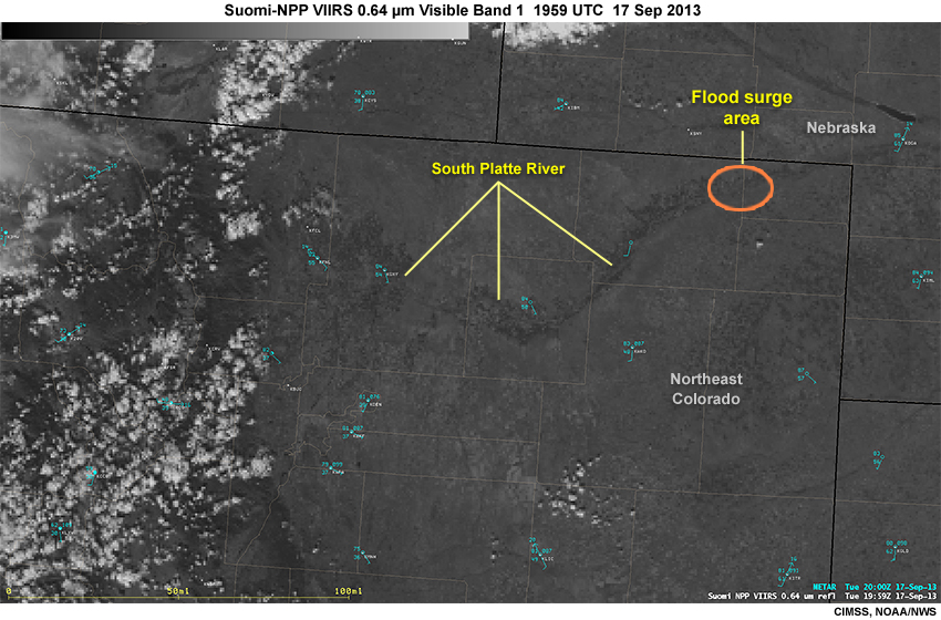
Description:
Suomi NPP VIIRS 0.64 visible band 1 image over northeastern Colorado during the September 2013 flood event, 2000 UTC, September 17, 2013
File Name:
snpp_viirs_vis_co_fldg_17sep13.jpg
Credits:
CIMSS, NOAA/NWS
Copyright Terms:
COMET Standard Terms of Use
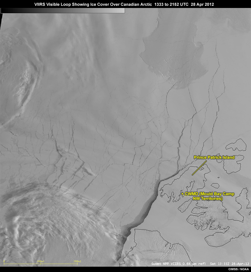
Description:
VIIRS visible loop showing ice cover over the Canadian Arctic with ice lead forming off west coast of Prince Patrick Island on April 28, 2012
File Name:
snpp_viirs_vis_ice_28apr12_ani.mp4
Credits:
CIMSS / NOAA
Copyright Terms:
COMET Standard Terms of Use
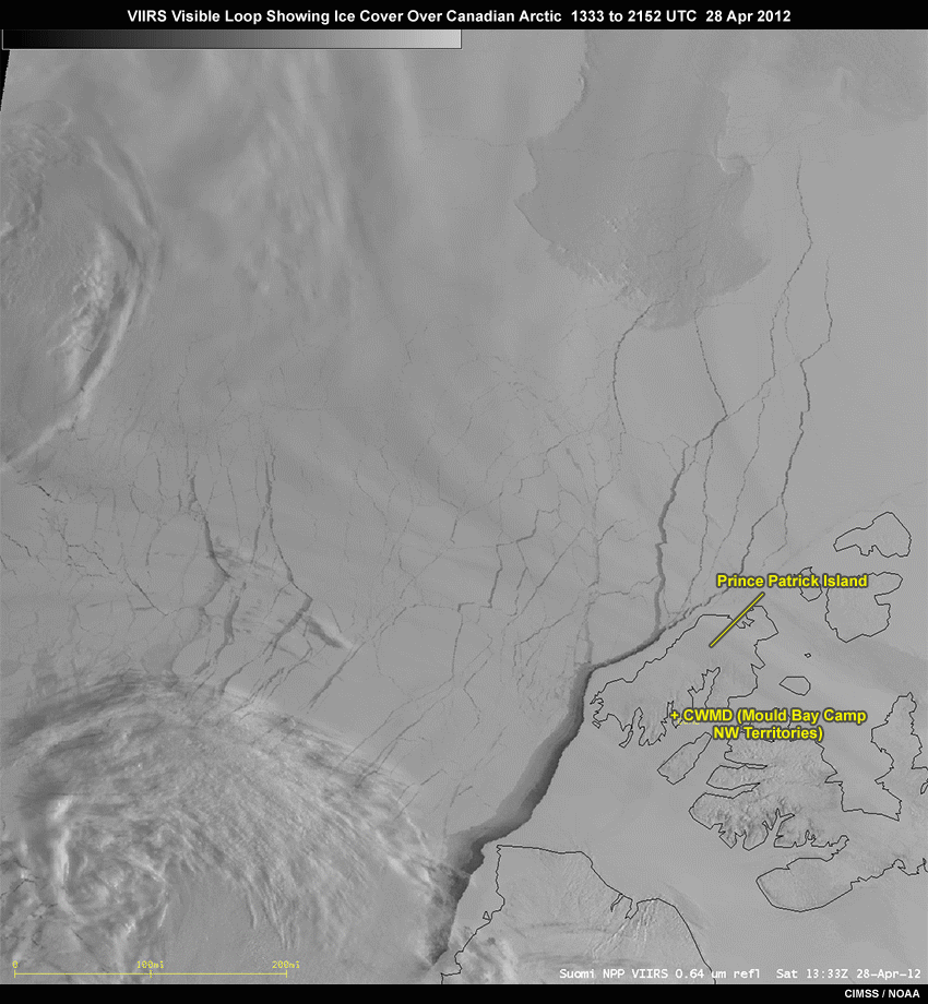
Description:
VIIRS visible loop showing ice cover over the Canadian Arctic with ice lead forming off west coast of Prince Patrick Island on April 28, 2012
File Name:
snpp_viirs_vis_ice_28apr12_ani.gif
Credits:
CIMSS / NOAA
Copyright Terms:
COMET Standard Terms of Use
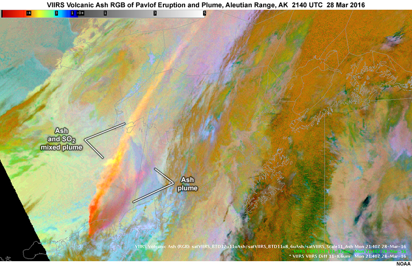
Description:
Suomi-NPP VIIRS volcanic ash RGB image showing ash plume from Alaska's Mount Pavlof eruption at 2140 UTC on March 28, 2016
File Name:
viirs_ash_rgb_pavlof_ak_28mar16.jpg
Credits:
NOAA
Copyright Terms:
COMET Standard Terms of Use
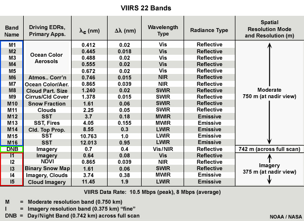
Description:
Table showing the Suomi NPP and JPSS polar orbiting satellite VIIRS imager's 22 bands, their characteristics and primary applications
File Name:
viirs_bands_updated_v3_highlight.jpg
Credits:
NOAA / NASA
Copyright Terms:
COMET Standard Terms of Use
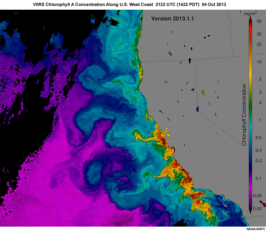
Description:
Suomi-NPP VIIRS derived ocean color product showing chlorophyll a concentration along the U.S West Coast on October 4, 2013
File Name:
viirs_chlor_a_04oct13.jpg
Credits:
NASA/GSFC
Copyright Terms:
COMET Standard Terms of Use
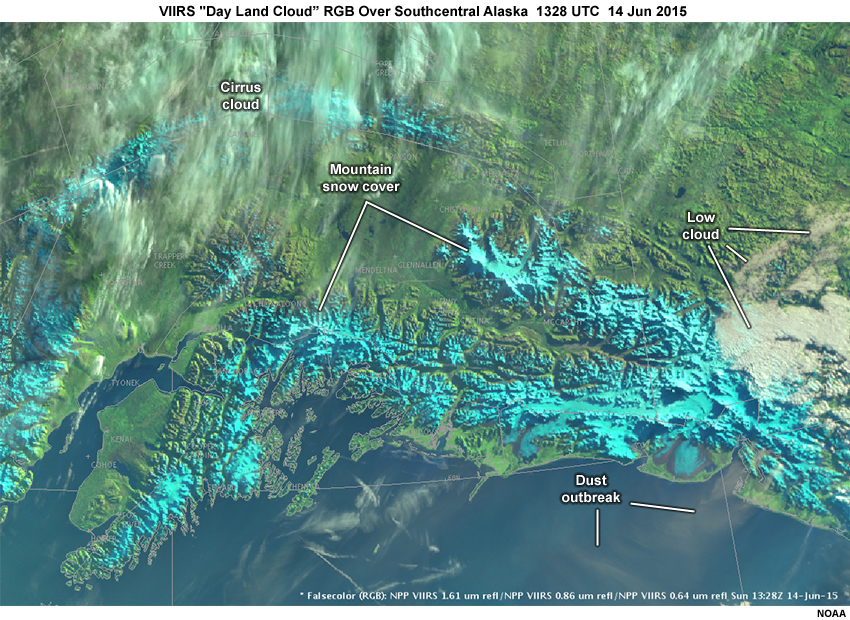
Description:
VIIRS Natural Color RGB image over Southcentral Alaska showing snow cover in cyan, cloud cover in light grey to white, and vegetated surfaces in green
File Name:
viirs_dayland_rgb_14jun15.jpg
Credits:
NOAA
Copyright Terms:
COMET Standard Terms of Use
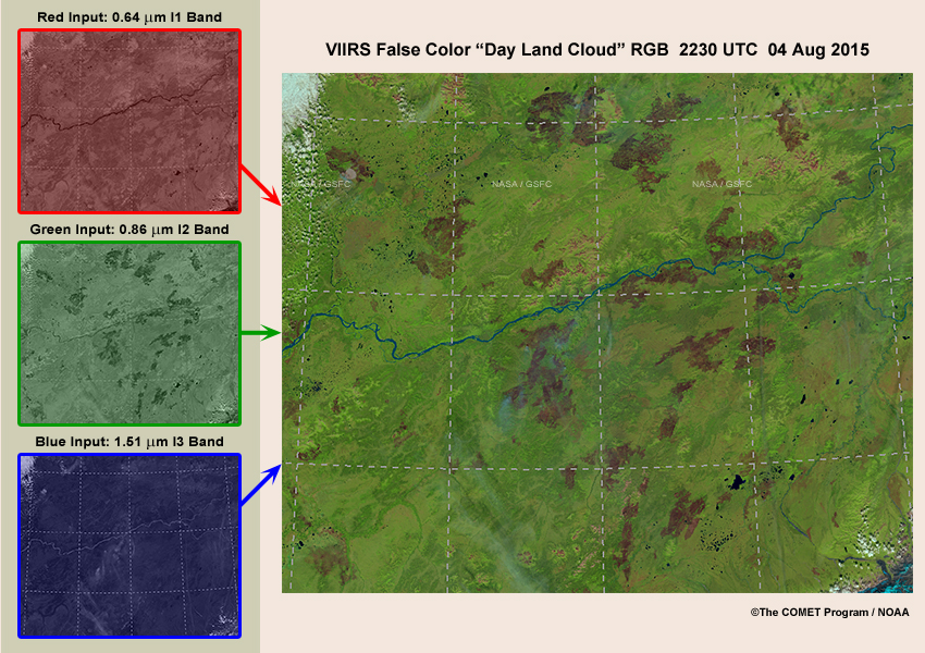
Description:
Image showing the three band input used to produce the VIIRS false color Day Land Cloud RGB, highlighting burn scars over Alaska on August 4, 2015
File Name:
viirs_fc_ak_burn_scars_04aug15.jpg
Credits:
©The COMET Program / NOAA
Copyright Terms:
COMET Standard Terms of Use
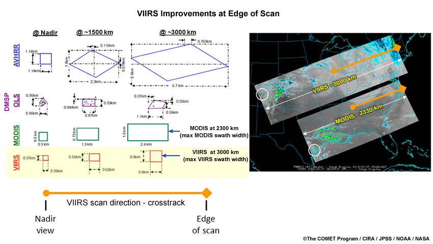
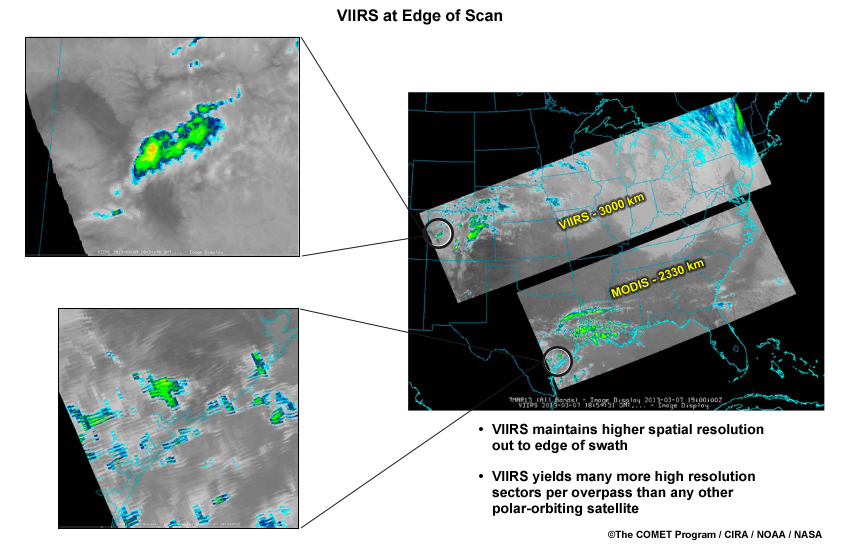
Description:
Comparison between VIIRS and other polar-orbiting satellite imagers demonstrating VIIRS improved resolution toward the edge of the instrument's scan
File Name:
viirs_imp_edge_of_scan.jpg
Credits:
©The COMET Program / CIRA / JPSS / NOAA / NASA
Copyright Terms:
COMET Standard Terms of Use
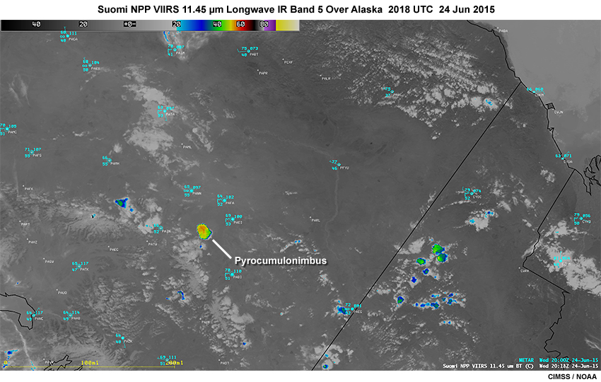
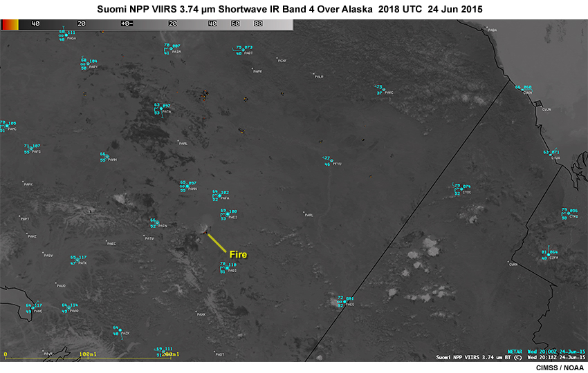
Description:
Suomi NPP VIIRS 11.45 micrometer longwave IR imagery band showing smoke from fires over Alaska at 2018 UTC on June 24, 2015
File Name:
viirs_lwir_ak_fires_24jun15.jpg
Credits:
CIMSS / NOAA
Copyright Terms:
COMET Standard Terms of Use
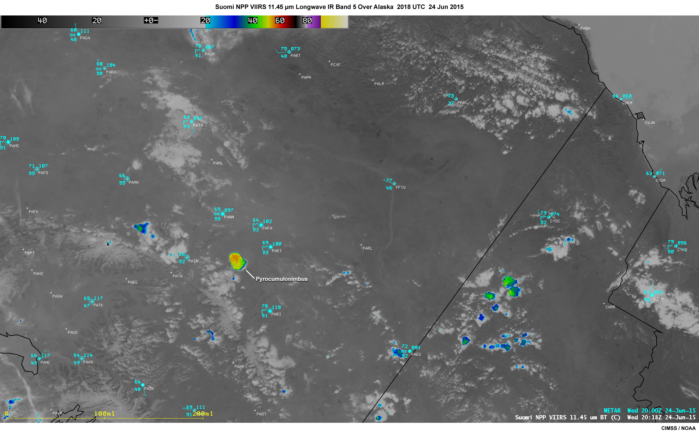
Description:
Suomi NPP VIIRS 11.45 micrometer longwave IR imagery band showing smoke from fires over Alaska at 2018 UTC on June 24, 2015
File Name:
viirs_lwir_ak_fires_24jun15_large.jpg
Credits:
CIMSS / NOAA
Copyright Terms:
COMET Standard Terms of Use
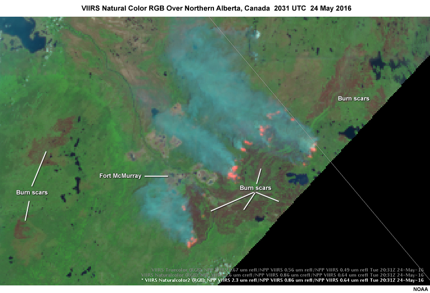
Description:
VIIRS Natural Color RGB image over northern Alberta, Canada in the region of the McMurray wildfires on 24 May 2016, showing fires in pink, smoke in dark cyan, and dark reddish areas that are burn scars marking past fires
File Name:
viirs_natcol2_alberta_fires_24may16.jpg
Credits:
NOAA
Copyright Terms:
COMET Standard Terms of Use
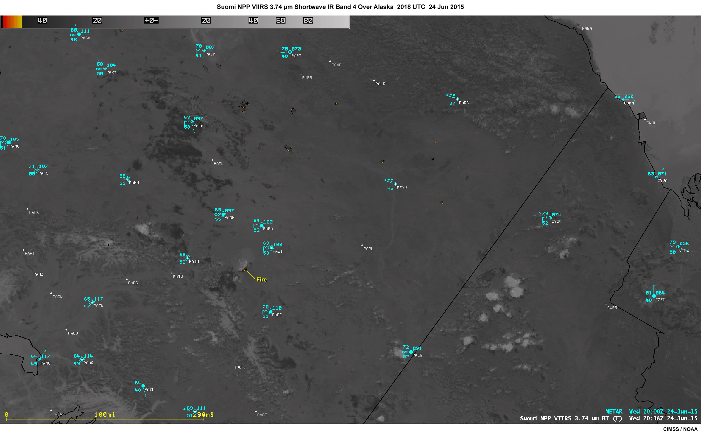
Description:
Suomi NPP VIIRS 3.7 micrometer shortwave IR imagery band showing smoke from fires over Alaska at 2018 UTC on June 24, 2015
File Name:
viirs_swir_ak_fires_24jun15.jpg
Credits:
CIMSS / NOAA
Copyright Terms:
COMET Standard Terms of Use
Description:
Suomi NPP VIIRS 3.7 micrometer shortwave IR imagery band showing smoke from fires over Alaska at 2018 UTC on June 24, 2015
File Name:
viirs_swir_ak_fires_24jun15_large.jpg
Credits:
CIMSS / NOAA
Copyright Terms:
COMET Standard Terms of Use
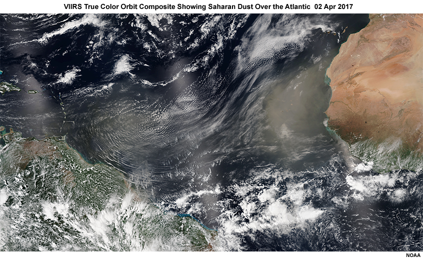
Description:
VIIRS true color multi-orbit composite showing Saharan dust over the Atlantic on April 2, 2017
File Name:
viirs_tc_atl_sal_02apr17.jpg
Credits:
NOAA
Copyright Terms:
COMET Standard Terms of Use
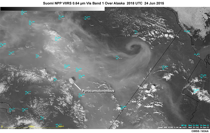
Description:
Suomi NPP VIIRS 0.64 micrometer visible imagery band showing smoke from fires over Alaska at 2018 UTC on June 24, 2015
File Name:
viirs_vis_ak_fires_24jun15.jpg
Credits:
CIMSS / NOAA
Copyright Terms:
COMET Standard Terms of Use
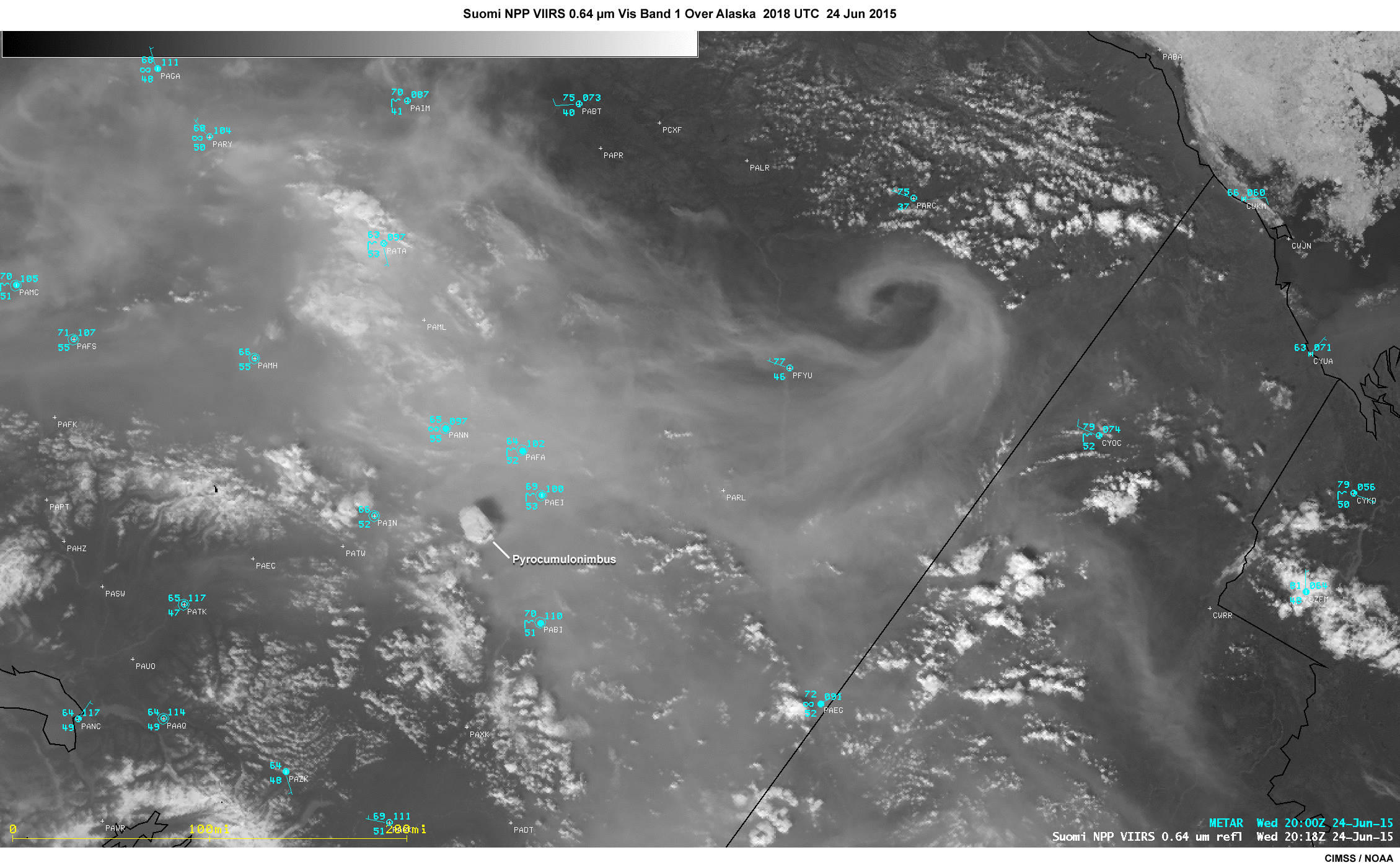
Description:
Suomi NPP VIIRS 0.64 micrometer visible imagery band showing smoke from fires over Alaska at 2018 UTC on June 24, 2015
File Name:
viirs_vis_ak_fires_24jun15_large.jpg
Credits:
CIMSS / NOAA
Copyright Terms:
COMET Standard Terms of Use
Description:
Plot highlighting the improved spatial resolution of VIIRS vs. MODIS using infrared imagery at the edge of scan from both imagers
File Name:
viirs_vs_modis_edge_of_scan.jpg
Credits:
©The COMET Program / CIRA / NOAA / NASA
Copyright Terms:
COMET Standard Terms of Use
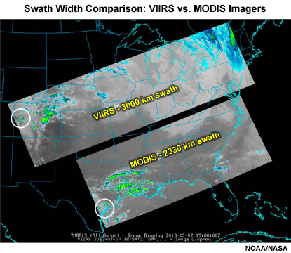
Description:
A side by side comparison of VIIRS and MODIS imager swath widths
File Name:
viirs_vs_modis_swath_widths.jpg
Credits:
NOAA / NASA
Copyright Terms:
COMET Standard Terms of Use