SatFC-J: Satellite Foundational Course for JPSS
The Advanced Microwave Scanning Radiometer 2 (AMSR2) Imager
Media elements used in this module are protected by a variety of copyright licenses. Please use the "copyright terms" link associated with each item below for more information.

Description:
AMSR-E 6 GHz image of Japan and surrounding area
File Name:
amsr_res_ex_6.jpg
Credits:
U.S. Navy / NRL / NASA
Copyright Terms:
COMET Standard Terms of Use

Description:
AMSR-E 89 GHz image of Japan and surrounding area
File Name:
amsr_res_ex_89.jpg
Credits:
U.S. Navy / NRL / NASA
Copyright Terms:
COMET Standard Terms of Use
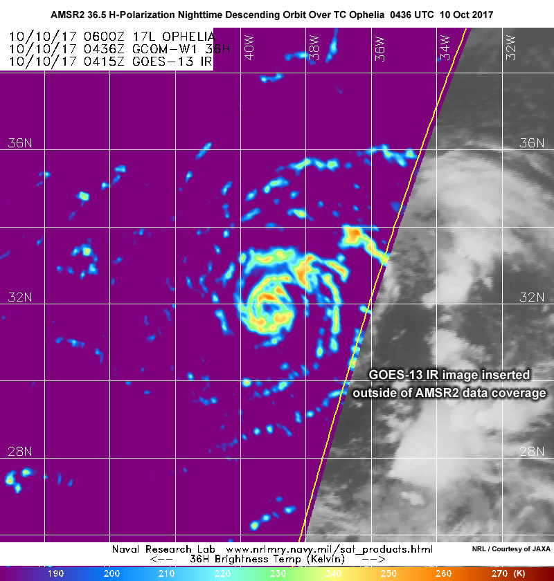
Description:
GCOM-W1 AMSR2 36.5 GHz horizontal polarization image from nighttime descending orbit over tropical storm Ophelia in the North Atlantic on October 10, 2017
File Name:
amsr2_36h_ophelia_10oct17.jpg
Credits:
NRL / Courtesy of JAXA
Copyright Terms:
COMET Standard Terms of Use
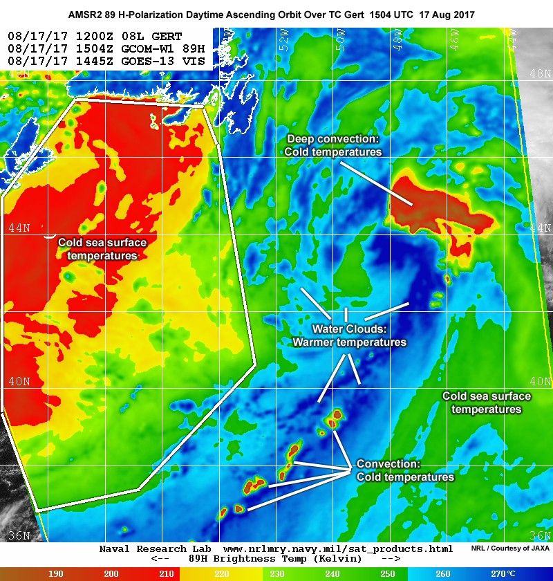
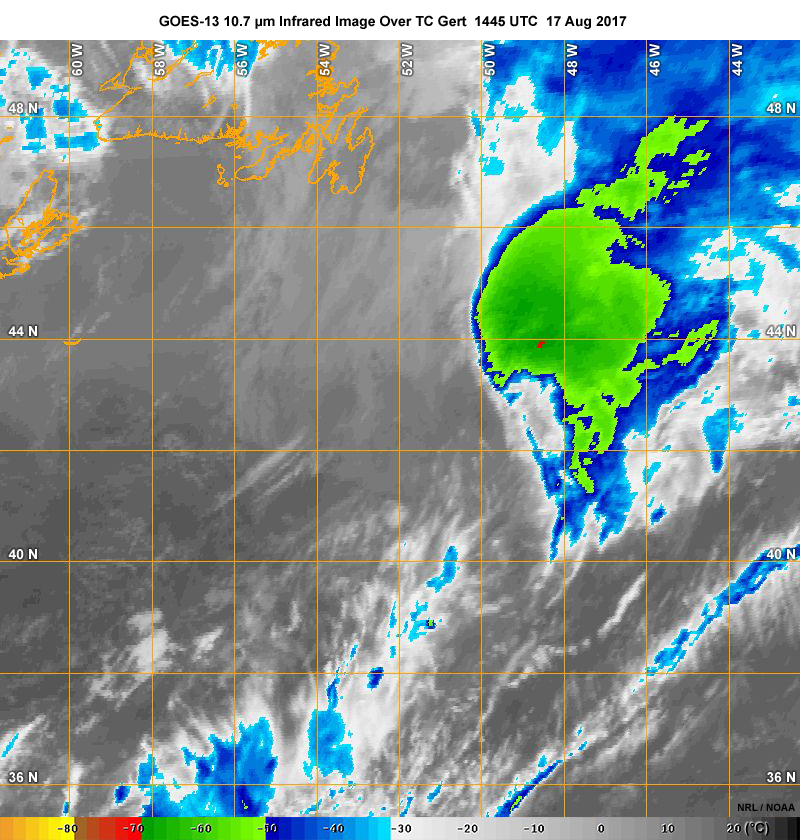
Description:
GCOM-W1 AMSR2 89 GHz horizontal polarization image from daytime ascending orbit over hurricane Gert in the North Atlantic on August 17, 2017
File Name:
amsr2_89h_gert_17aug17.jpg
Credits:
NRL / Courtesy of JAXA
Copyright Terms:
COMET Standard Terms of Use
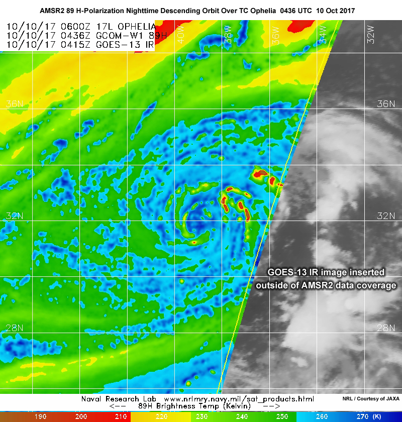
Description:
GCOM-W1 AMSR2 89 GHz horizontal polarization image from nighttime descending orbit over tropical storm Ophelia in the North Atlantic on October 10, 2017
File Name:
amsr2_89h_ophelia_10oct17.jpg
Credits:
NRL / Courtesy of JAXA
Copyright Terms:
COMET Standard Terms of Use
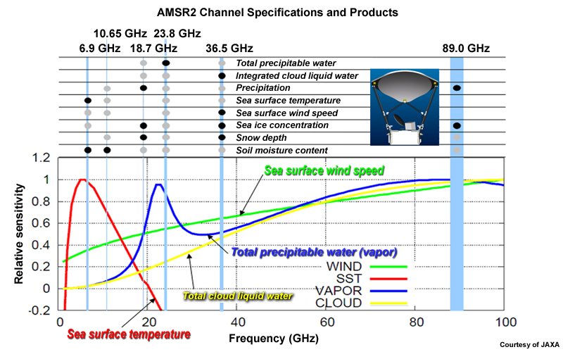
Description:
Table showing AMSR2 channel specifications, spectral sensitivities, and products
File Name:
amsr2_channels_specs_apps_table.jpg
Credits:
Courtesy of JAXA
Copyright Terms:
COMET Standard Terms of Use
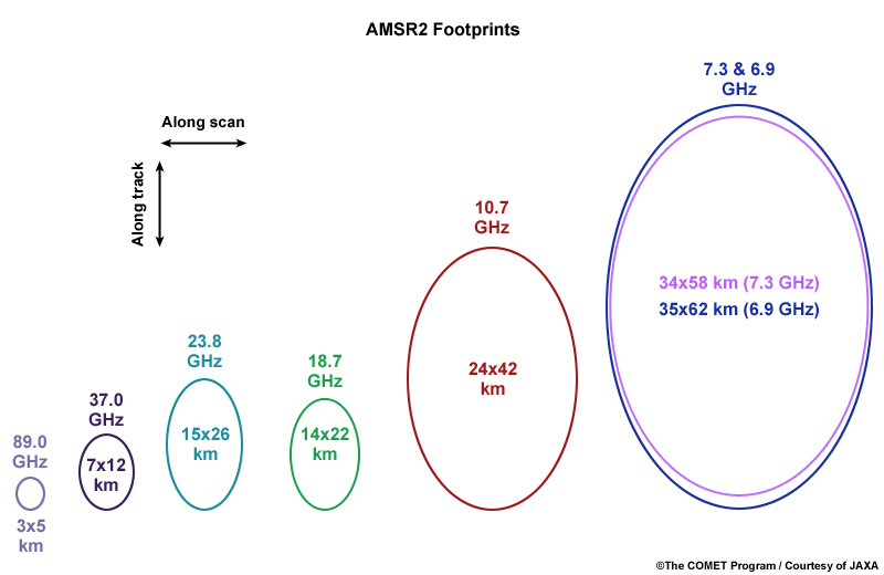
Description:
Schematic showing AMSR2 footprints
File Name:
amsr2_footprint_changes.jpg
Credits:
The COMET Program/Courtesy of JAXA
Copyright Terms:
COMET Standard Terms of Use
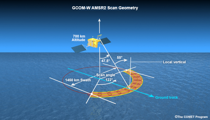
Description:
Illustration of AMSR-2 scan geometry on board the GCOM-W polar-orbiting satellites.
File Name:
amsr2_scan.jpg
Credits:
©The COMET Program
Copyright Terms:
COMET Standard Terms of Use
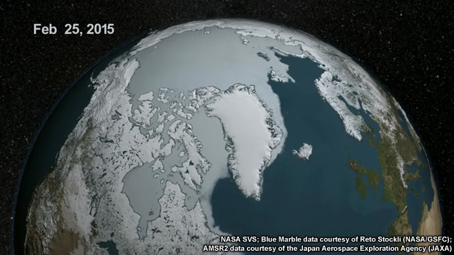
Description:
Animation showing AMSR-2 sea surface temperature and MODIS seasonal landcover for February through September 2015.
File Name:
amsr2_seaice_2015.mp4
Credits:
NASA SVS; Blue Marble data courtesy of Reto Stockli (NASA/GSFC); AMSR2 data courtesy of the Japan Aerospace Exploration Agency (JAXA)
Copyright Terms:
COMET Standard Terms of Use
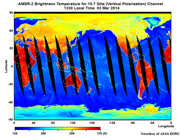
Description:
Global 24-hour composite of AMSR-2 brightness temperatures for the 10.7 GHz channel (vertical polarization), ascending orbits, on 3 March, 2014.
File Name:
amsr2_tb10v_03mar14_wider.jpg
Credits:
Courtesy of JAXA EORC
Copyright Terms:
COMET Standard Terms of Use
Description:
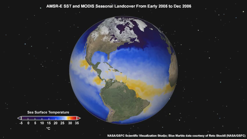
Animation showing AMSR-E sea surface temperature and MODIS seasonal landcover from early 2005 to Dec 2006.
File Name:
amsre_sst_ani.mp4
Credits:
NASA/GSFC Scientific Visualization Studio; Blue Marble data courtesy of Reto Stockli (NASA/GSFC)
Copyright Terms:
COMET Standard Terms of Use
Description:
GOES-13 10.7 micrometer infrared image over hurricane Gert in the North Atlantic on August 17, 2017
File Name:
g13_ir4_gert_17aug17.jpg
Credits:
NRL / NOAA
Copyright Terms:
COMET Standard Terms of Use
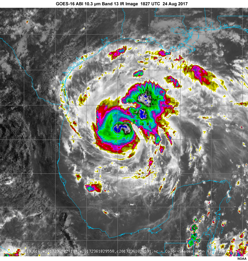
Description:
GOES-16 10.3 micrometer band 13 infrared image showing hurricane Harvey on August 24, 2017, strengthening over the Gulf of Mexico before landfall along the Texas coast
File Name:
g16_b13_1827utc_24aug17.jpg
Credits:
NOAA
Copyright Terms:
COMET Standard Terms of Use
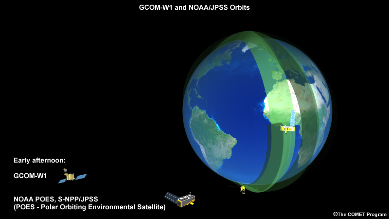
Description:
Animation showing JAXA's GCOM-W1 and NOAA's S-NPP/JPSS-1 polar-orbiting satellites during their ascending orbits across North America
File Name:
gcom_jpss_orbits.mp4
Credits:
©The COMET Program
Copyright Terms:
COMET Standard Terms of Use
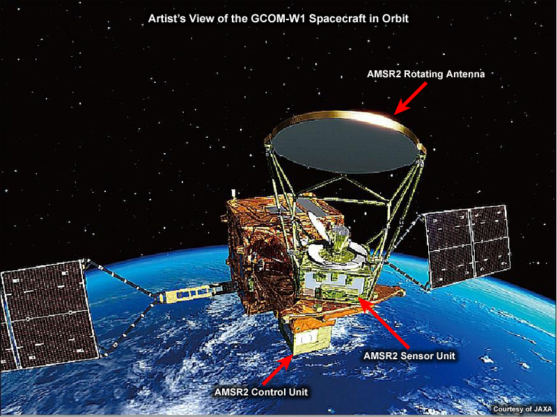
Description:
Artist's rendition of JAXA's GCOM-W1 spacecraft in orbit above Earth
File Name:
gcom_w1_spacecraft_and_amsr2.jpg
Credits:
Courtesy of JAXA
Copyright Terms:
COMET Standard Terms of Use
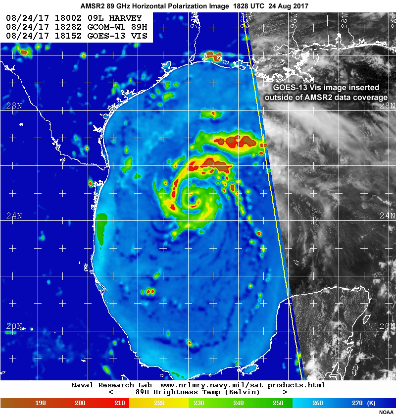
Description:
GCOM-W1 AMSR2 89 GHz horizontal polarization channel image showing circulation of hurricane Harvey on August 24, 2017, strengthening over the Gulf of Mexico before landfall along the Texas coast
File Name:
gcomw1_amsr2_89h_1828utc_24aug17.jpg
Credits:
NOAA
Copyright Terms:
COMET Standard Terms of Use
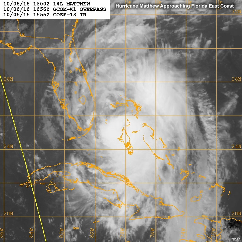
Description:
GOES longwave IR image of Hurricane Matthew approaching the Florida east coast, 6 Oct 2016
File Name:
matthew_6oct2016_amsr2_ir.jpg
Credits:
NOAA
Copyright Terms:
COMET Standard Terms of Use
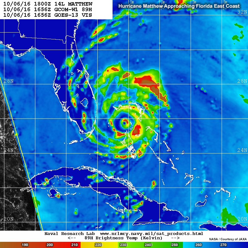
Description:
GOES longwave IR image of Hurricane Matthew approaching the Florida east coast, 6 Oct 2016
File Name:
matthew_6oct2016_amsr2_vis.jpg
Credits:
NASA/Courtesy of JAXA
Copyright Terms:
COMET Standard Terms of Use
Description:
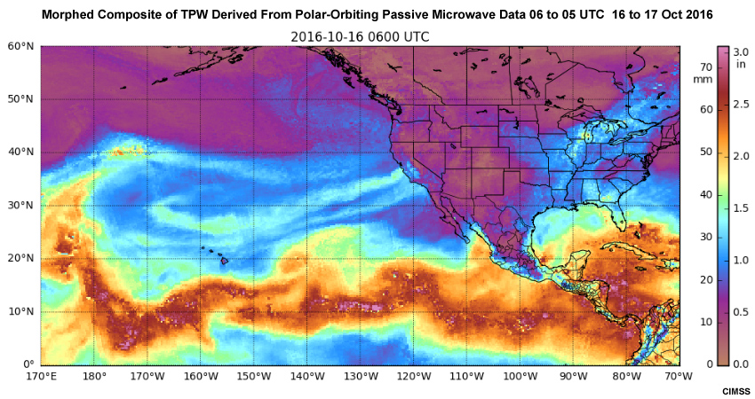
Morphed composite of TPW and passive microwave data, including AMSR at 10 UTC on 16 Oct 2016
File Name:
morphed_mimic_tpw_16oct2016_ani.mp4
Credits:
CIMSS
Copyright Terms:
COMET Standard Terms of Use
Description:
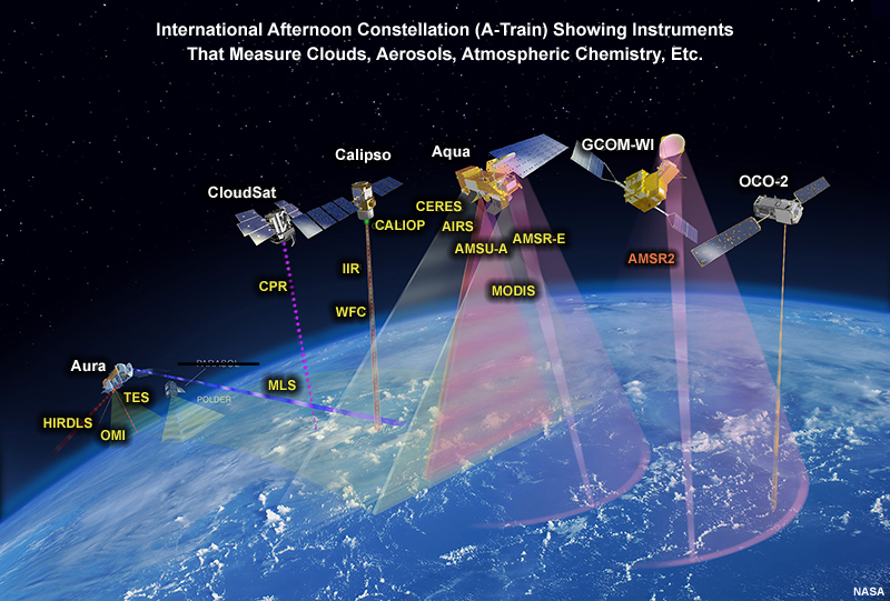
Depiction of the constellation of afternoon A-train satellites and their coverage, updated 2013
File Name:
nasa_a_train2013.jpg
Credits:
NASA
Copyright Terms:
COMET Standard Terms of Use

Description:
Image showing SST anomalies based on AMSR2 SST observations compared against climatology, valid 10 to 14 November, 2016
File Name:
sst_amsr2_anomalies.jpg
Credits:
Courtesy of JAXA
Copyright Terms:
COMET Standard Terms of Use