Media elements used in this lesson are protected by a variety of copyright licenses. Please use the "copyright terms" link associated
with each item below for more information.
Click an image to view it at full size in a new browser window/tab.
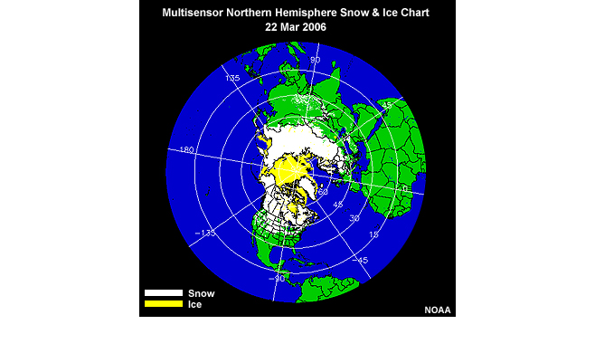
description:
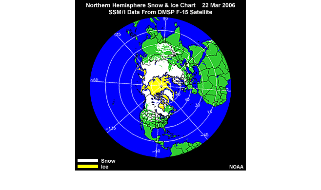
NOAA Northern Hemisphere snow and ice chart derived from SSM/I microwave data on the DMSP-15 polar-orbiting satellite, valid for 22 March, 2006.
file name:
20060322_snow_ice_f15_rotated_lg.jpg
credits:
NOAA / NESDIS
copyright terms:
COMET Standard Terms of Use
|
description:
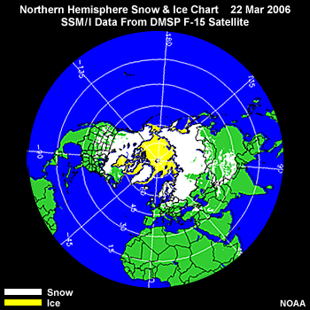
NOAA Northern Hemisphere snow and ice chart derived from SSM/I microwave data on the DMSP-15 polar-orbiting satellite, valid for 22 March, 2006.
file name:
20060322snowiceF15.jpg
credits:
NOAA / NESDIS
copyright terms:
COMET Standard Terms of Use
|
description:
Two panel layout showing NOAA Northern Hemisphere snow and ice chart derived from SSM/I microwave data on the DMSP-15 polar-orbiting satellite, valid for 22 March, 2006 (left panel), and snow water equivalent for the Northern Hemisphere based on visible and SSM/I passive microwave data taken during March 2005 (right panel).
file name:
20060322snowiceF15__ssmi_swe_monthly_clim_mar2005_2pan.jpg
credits:
NOAA/NESDIS (left) NSIDC (right)
copyright terms:
COMET Standard Terms of Use
|
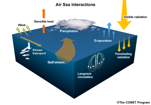
description:
Schematic of general air-sea interactions involving transfer of momentum, heat, moisture, and radiation.
file name:
air_sea_interaction_dynamics.jpg
credits:
©The COMET Program
copyright terms:
COMET Standard Terms of Use
|
view loop
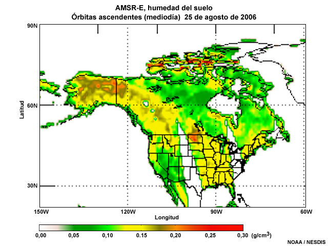
description:
Animation of soil moisture product composite over North America from the Aqua AMSR-E microwave imager during early afternoon local time for 25, 26, and 28 August 2006.
file name:
amsr_soilm_loop_0001.htm
credits:
NOAA / NESDIS
copyright terms:
COMET Standard Terms of Use
|

description:
Soil moisture product composite over North America from the Aqua AMSR-E microwave imager during early afternoon local time on 25 August 2006.
file name:
amsr_soilm1.jpg
credits:
NOAA / NESDIS
copyright terms:
COMET Standard Terms of Use
|

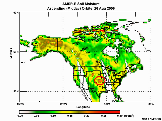
description:
Soil moisture product composite over North America from the Aqua AMSR-E microwave imager during early afternoon local time on 26 August 2006.
file name:
amsr_soilm2.jpg
credits:
NOAA / NESDIS
copyright terms:
COMET Standard Terms of Use
|
description:
Soil moisture product composite over North America from the Aqua AMSR-E microwave imager during early afternoon local time on 26 August 2006.
file name:
amsr_soilm2_scgrab.jpg
credits:
NOAA / NESDIS
copyright terms:
COMET Standard Terms of Use
|
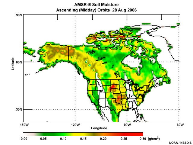
description:
Soil moisture product composite over North America from the Aqua AMSR-E microwave imager during early afternoon local time on 28 August 2006.
file name:
amsr_soilm3.jpg
credits:
NOAA / NESDIS
copyright terms:
COMET Standard Terms of Use
|
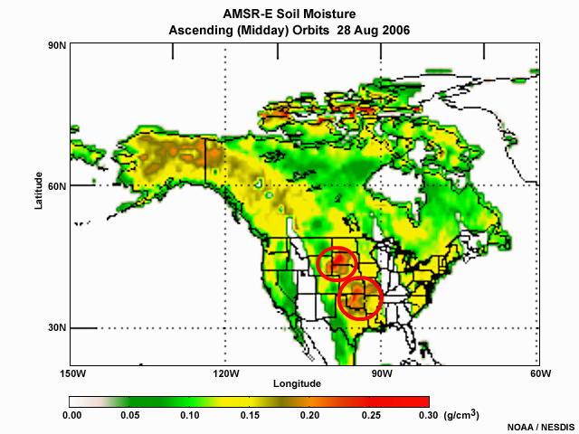
description:
Soil moisture product composite over North America from the Aqua AMSR-E microwave imager during early afternoon local time on 28 August 2006.
file name:
amsr_soilm3_scgrab.jpg
credits:
NOAA / NESDIS
copyright terms:
COMET Standard Terms of Use
|
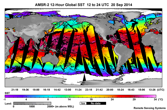
description:
AMSR-2 global 12-hour SST composite for 11 to 24 UTc on 20 September, 2014.
file name:
amsr2_12hr_sst_20sep14.jpg
credits:
Remote Sensing Systems
copyright terms:
COMET Standard Terms of Use
|
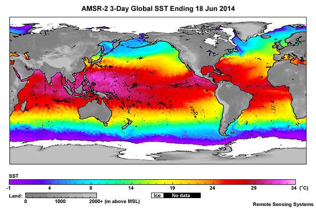
description:
AMSR-2 global 3-day SST composite ending on 18 June, 2005.
file name:
amsr2_3day_sst_18jun14.jpg
credits:
Remote Sensing Systems
copyright terms:
COMET Standard Terms of Use
|
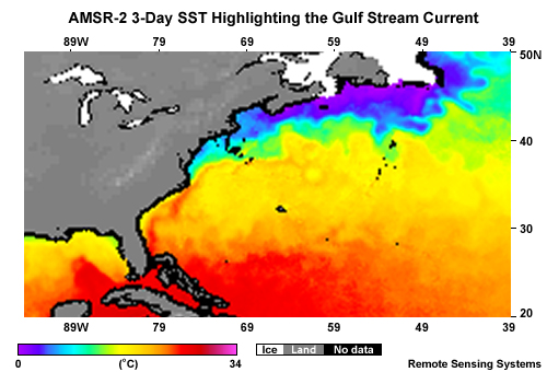
description:
GCOM-W1 AMSR-2 3-day SST composite highlighting the Gulf Stream and strong temperature gradient along the north side of the Atlantic Ocean Gulf Stream current ending on and including February 15, 2014.
file name:
amsr2_3day_sst_gulf_stream_ocean_front_15feb14.jpg
credits:
Remote Sensing Systems
copyright terms:
COMET Standard Terms of Use
|

description:
GCOM-W1 AMSR-2 3-day SST composite highlighting the Gulf Stream and strong temperature gradient along the north side of the Atlantic Ocean Gulf Stream current ending on and including February 15, 2014.
file name:
amsr2_3day_sst_gulf_stream_ocean_front_box_15feb14.jpg
credits:
Remote Sensing Systems
copyright terms:
COMET Standard Terms of Use
|
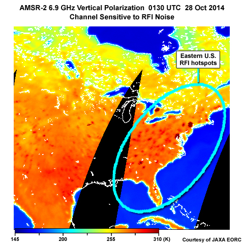
description:
AMSR-2 6.9 GHz vertical polarization image taken over eastern U.S. showing radio frequency interference contamination or hot spots.
file name:
amsr2_6ghz_rfi.jpg
credits:
Courtesy of JAXA EORC
copyright terms:
COMET Standard Terms of Use
|
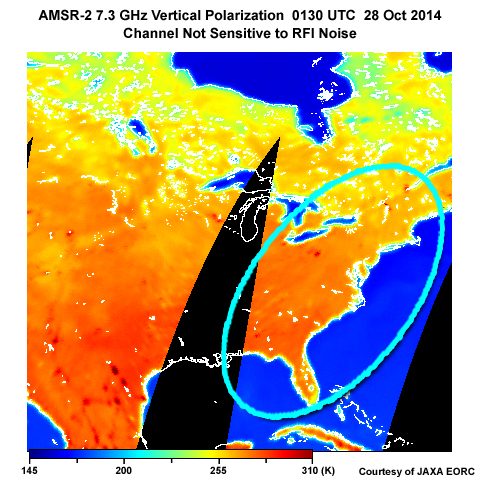
description:
AMSR-2 7.3 GHz vertical polarization image taken over eastern U.S. showing little or no radio frequency interference contamination or hot spots.
file name:
amsr2_7ghz_rfi.jpg
credits:
Courtesy of JAXA EORC
copyright terms:
COMET Standard Terms of Use
|
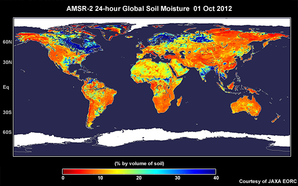
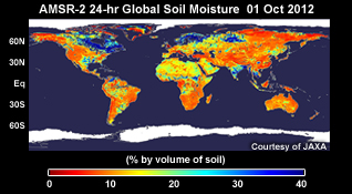
description:
AMSR-2 daily global soil moisture composite product for October 1, 2012.
file name:
amsr2_daily_sm_01oct12.jpg
credits:
Courtesy of JAXA EORC
copyright terms:
COMET Standard Terms of Use
|
description:
AMSR-2 daily global soil moisture composite product for October 1, 2012.
file name:
amsr2_daily_sm_01oct12_sm2.jpg
credits:
Courtesy of JAXA EORC
copyright terms:
COMET Standard Terms of Use
|
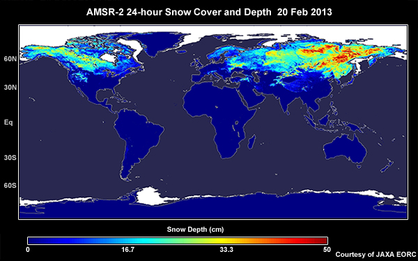
description:
Daily 24-hour global snow cover and snow depth (cm) product composite from the AMSR-2 instrument on board the GCOM-W1 satellite for February 20, 2013.
file name:
amsr2_daily_snowcover_20feb13.jpg
credits:
Courtesy of JAXA EORC
copyright terms:
COMET Standard Terms of Use
|
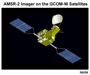
description:
Illustration of a GCOM-W satellite. Three are planned for the series.
file name:
amsr2_gcom_satellites.jpg
credits:
NASA
copyright terms:
COMET Standard Terms of Use
|

description:
Illustration of AMSR-2 scan geometry on board the GCOM-W polar-orbiting satellites.
file name:
amsr2_scan.jpg
credits:
©The COMET Program
copyright terms:
COMET Standard Terms of Use
|
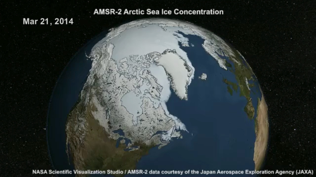
view/save .mp4 file
description:
Animation of AMSR-2 daily sea ice cover and concentratio product over the Northern Hemisphere from 21 March to 3 August, 2014.
file name:
amsr2_seaice_conc_np_2014.mp4
credits:
NASA Scientific Visualization Studio / AMSR-2 data courtesy of the Japan Aerospace Exploration Agency (JAXA)
copyright terms:
COMET Standard Terms of Use
|
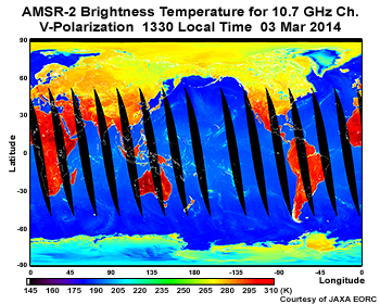
description:
Global 24-hour composite of AMSR-2 brightness temperatures for the 10.7 GHz channel (vertical polarization), ascending orbits, 1330 local standard time, on March 3, 2014.
file name:
amsr2_tb10v_03mar14.jpg
credits:
Courtesy of JAXA EORC
copyright terms:
COMET Standard Terms of Use
|
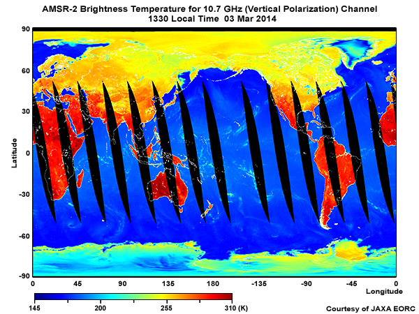
description:
Global 24-hour composite of AMSR-2 brightness temperatures for the 10.7 GHz channel (vertical polarization), ascending orbits, on 3 March, 2014.
file name:
amsr2_tb10v_03mar14_wider.jpg
credits:
Courtesy of JAXA EORC
copyright terms:
COMET Standard Terms of Use
|
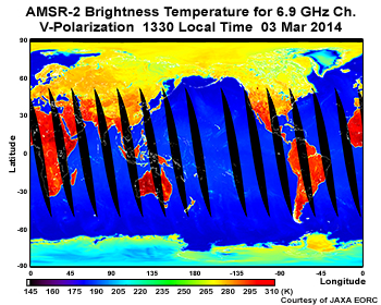
description:
Global 24-hour composite of AMSR-2 brightness temperatures for the 6.9 GHz channel (vertical polarization), ascending orbits, 1330 local standard time, on March 3, 2014.
file name:
amsr2_tb6v_03mar14.jpg
credits:
Courtesy of JAXA EORC
copyright terms:
COMET Standard Terms of Use
|
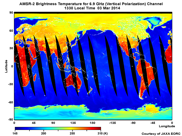
description:
Global 24-hour composite of AMSR-2 brightness temperatures for the 6.9 GHz channel (vertical polarization), ascending orbits, on 3 March, 2014.
file name:
amsr2_tb6v_03mar14_wider.jpg
credits:
Courtesy of JAXA EORC
copyright terms:
COMET Standard Terms of Use
|
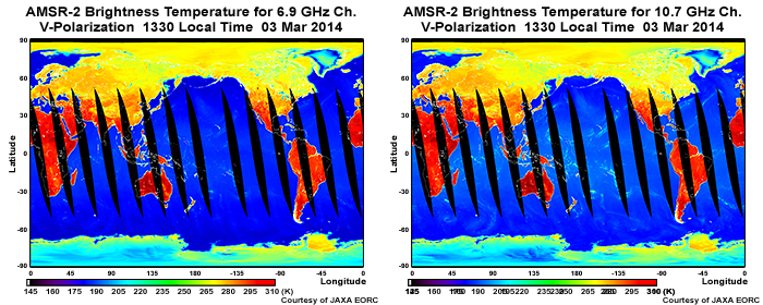
description:
Global 24-hour composite of AMSR-2 brightness temperatures for the 6.9 GHz channel (vertical polarization), ascending orbits, on 3 March, 2014.
file name:
amsr2_tb6v_10v_03mar14_2panel.jpg
credits:
Courtesy of JAXA EORC
copyright terms:
COMET Standard Terms of Use
|
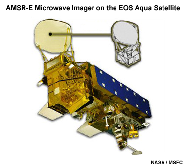
description:
Artists rendition of the EOS Aqua satellite and the AMSR-E microwave imager.
file name:
amsrcraft.jpg
credits:
NASA / MSFC
copyright terms:
COMET Standard Terms of Use
|

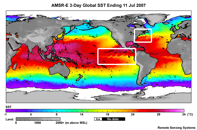
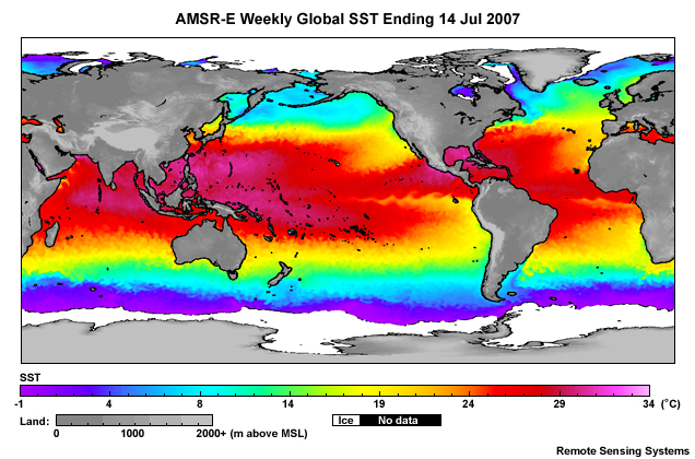
description:
AMSR-E global 3-day SST composite ending on 11 July, 2007.
file name:
amsre_3day_sst_11jul07.jpg
credits:
Remote Sensing Systems
copyright terms:
COMET Standard Terms of Use
|
description:
AMSR-E global 3-day SST composite ending on 11 July, 2007 with highlights outlining Pacific equatorial current and Gulf Stream current.
file name:
amsre_3day_sst_11jul07_scgrab.jpg
credits:
Remote Sensing Systems
copyright terms:
COMET Standard Terms of Use
|
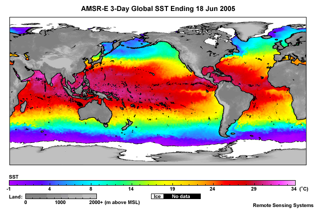
description:
AMSR-E global 3-day SST composite ending on 18 June, 2005.
file name:
amsre_3day_sst_18jun05.jpg
credits:
Remote Sensing Systems
copyright terms:
COMET Standard Terms of Use
|
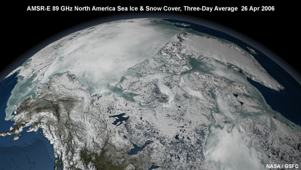
description:
Aqua AMSR-E 89GHz three-day average of snow and ice cover over North America on 26 April, 2006.
file name:
amsre_89ghz_no_am_seaice.jpg
credits:
NASA / GSFC
copyright terms:
COMET Standard Terms of Use
|
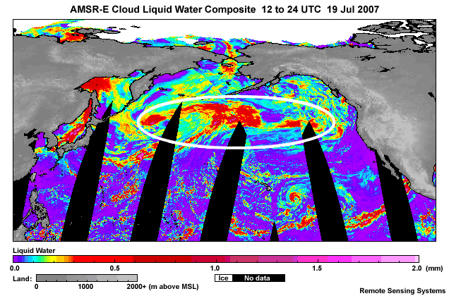
description:
AMSR-E cloud liquid water product focusing on North Pacific storm system for orbits between 12 and 24 UTC on 19 Jul 2007.
file name:
amsre_clw_19jul07_scgrab.jpg
credits:
Remote Sensing Systems
copyright terms:
COMET Standard Terms of Use
|
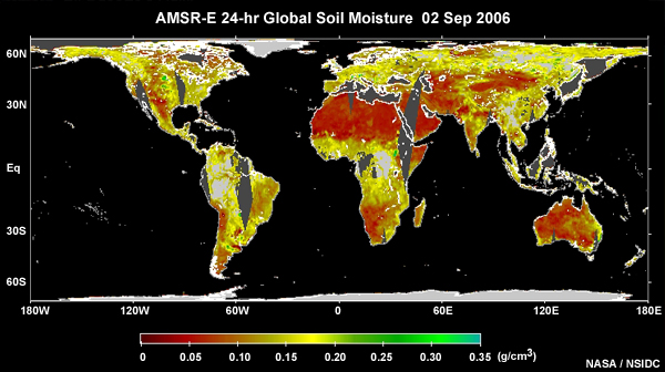
description:
AMSR-E daily global soil moisture composite product for 02 September 2006.
file name:
amsre_daily_sm_02sep06.jpg
credits:
NASA / NSIDC
copyright terms:
COMET Standard Terms of Use
|
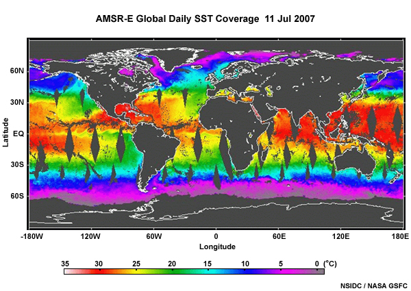
description:
AMSR-E global daily SST coverage for 11 July, 2007.
file name:
amsre_daily_SST_11Jul07.jpg
credits:
NSIDC / NASA GSFC
copyright terms:
COMET Standard Terms of Use
|

view loop
description:
Animation of AMSR-E global monthly SST from July 2006 to July 2007.
file name:
amsre_monthly_sst_jul0607_loop_0001.htm
credits:
Remote Sensing Systems
copyright terms:
COMET Standard Terms of Use
|
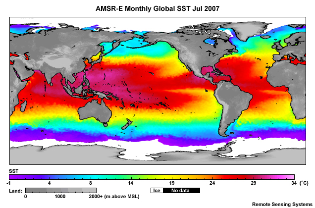
description:
AMSR-E global monthly SST composite for July 2007.
file name:
amsre_monthly_sst_jul07.jpg
credits:
Remote Sensing Systems
copyright terms:
COMET Standard Terms of Use
|
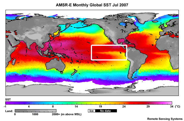
description:
AMSR-E global monthly SST composite for July 2007 with box highlighting the East Pacific equatorial current.
file name:
amsre_monthly_sst_jul07_scgrab.jpg
credits:
Remote Sensing Systems
copyright terms:
COMET Standard Terms of Use
|
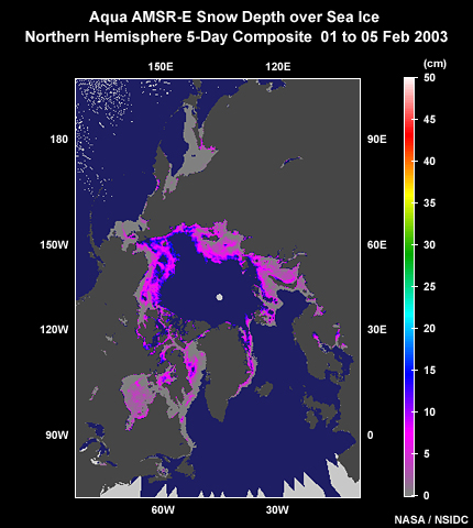
description:
Aqua AMSR-E 5-day snow depth over sea ice composite covering the Northern Hemisphere Polar regions from 1 to 5 February, 2003.
file name:
amsre_np_5day_snowdepth_05feb2003.jpg
credits:
NASA / NSIDC
copyright terms:
COMET Standard Terms of Use
|
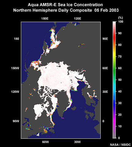
description:
Aqua AMSR-E multi-orbit composite sea ice concentration product covering Northern Hemisphere Polar regions for 5 February, 2003.
file name:
amsre_np_daily_seaice_05feb2003.jpg
credits:
NASA / NSIDC
copyright terms:
COMET Standard Terms of Use
|
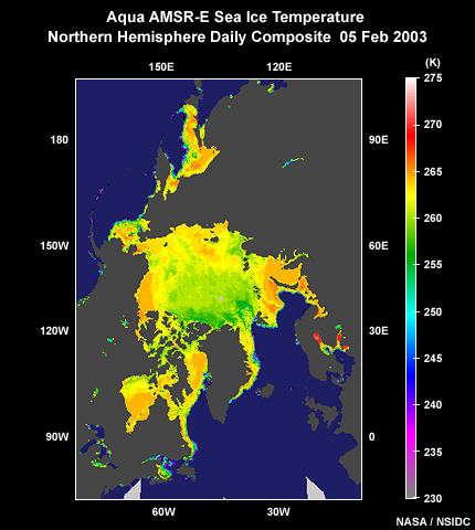
description:
Aqua AMSR-E daily sea ice temperature composite covering the Northern Hemisphere Polar regions on 05 February, 2003.
file name:
amsre_np_seaice_temp_05feb2003.jpg
credits:
NASA / NSIDC
copyright terms:
COMET Standard Terms of Use
|
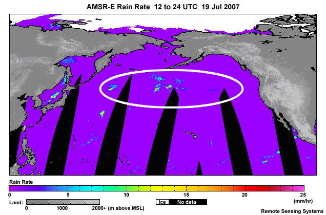
description:
AMSR-E rain rate product focusing on North Pacific storm system for orbits between 12 and 24 UTC on 19 Jul 2007.
file name:
amsre_rain_rate_19jul07_scgrab.jpg
credits:
Remote Sensing Systems
copyright terms:
COMET Standard Terms of Use
|
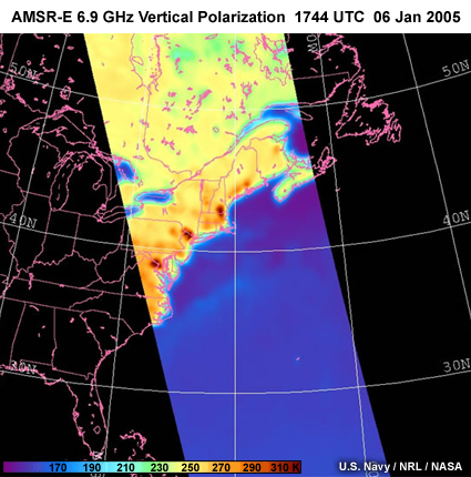
description:
AMSR-E 6 GHz vertical polarization image taken over northeastern U.S. showing radio frequency interference contamination or hot spots.
file name:
amsre_rfi.jpg
credits:
U.S. Navy / NRL / NASA
copyright terms:
COMET Standard Terms of Use
|
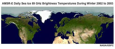
view/save .mp4 file
description:
Animation of AMSR-E daily 89 GHz brightness temperatures covering the Northern Hemisphere during winter of 2002 to 2003.
file name:
amsre_seaice_daily_200203.mp4
credits:
NASA / GSFC
copyright terms:
COMET Standard Terms of Use
|
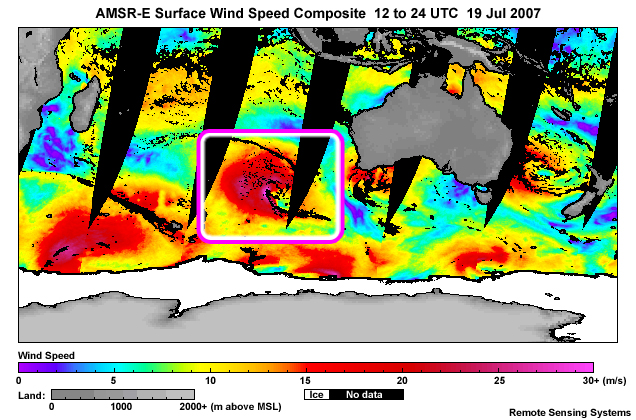
description:
AMSR-E near ocean surface wind speed product focusing on extratropical storm system over the South Indian Ocean for orbits between 12 and 24 UTC on 19 Jul 2007 with focus on region of strong ocean surface winds.
file name:
amsre_sfc_wind_speed_crop_19jul07_scgrab.jpg
credits:
Remote Sensing Systems
copyright terms:
COMET Standard Terms of Use
|
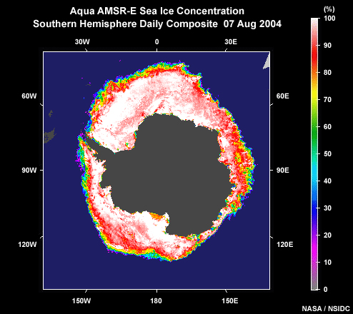
description:
Aqua AMSR-E multi-orbit composite sea ice concentration product covering Southern Hemisphere Polar Regions for 7 August, 2004.
file name:
amsre_sp_daily_seaice_07aug04.jpg
credits:
NASA / NSIDC
copyright terms:
COMET Standard Terms of Use
|
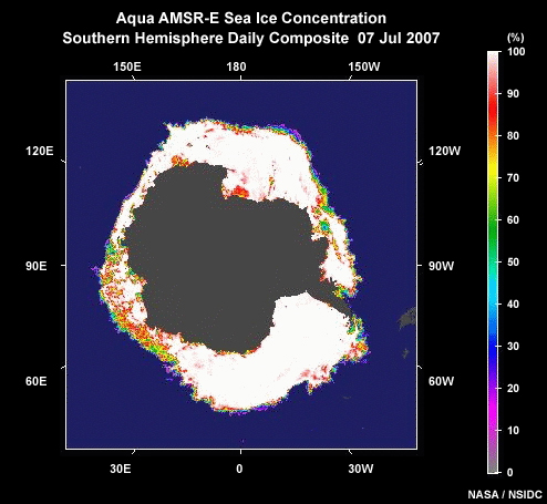
description:
Aqua AMSR-E sea ice concentration for daily orbits on 7 July, 2007.
file name:
amsre_sp_seaice_07jul07.jpg
credits:
NASA / NSIDC
copyright terms:
COMET Standard Terms of Use
|
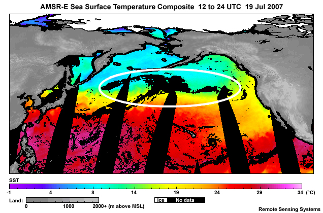
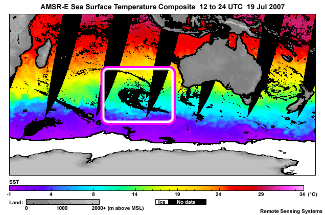
description:
AMSR-E sea surface temperature product focusing on North Pacific storm system for orbits between 12 and 24 UTC on 19 Jul 2007 with outline over the North Pacific.
file name:
amsre_sst_19jul07_scgrab.jpg
credits:
Remote Sensing Systems
copyright terms:
COMET Standard Terms of Use
|
description:
AMSR-E sea surface temperature product focusing on extratropical storm system over the South Indian Ocean for orbits between 12 and 24 UTC on 19 Jul 2007.
file name:
amsre_sst_crop_19jul07_scgrab.jpg
credits:
Remote Sensing Systems
copyright terms:
COMET Standard Terms of Use
|

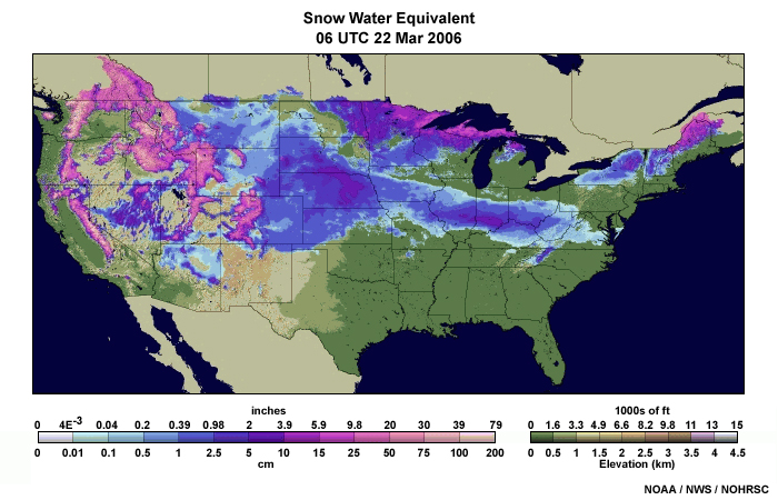
description:
Snow water equivalent analysis from AMSR-E microwave imager over North American on 22 January 2006.
file name:
amsre_swe_nam1.gif
credits:
NOAA / NESDIS
copyright terms:
COMET Standard Terms of Use
|
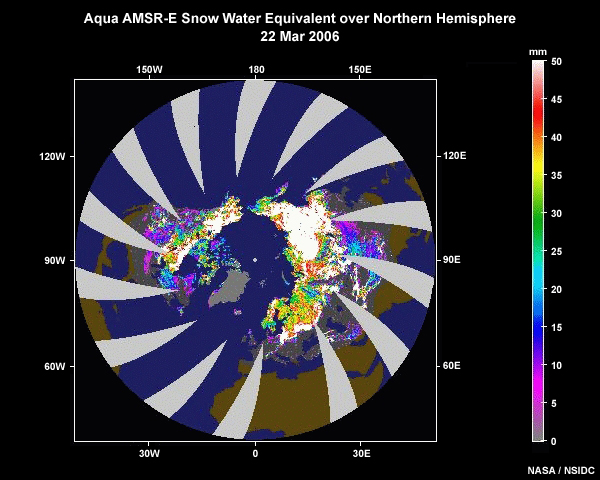
description:
Snow water equivalent analysis from the AMSR-E microwave imager for the Northern Hemisphere from 24 hours of descending orbits (nighttime local time) on 22 March 2006.
file name:
amsre_swe_nhem1.jpg
credits:
NASA / NSIDC
copyright terms:
COMET Standard Terms of Use
|
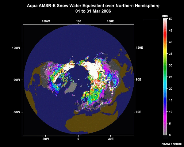
description:
Snow water equivalent analysis from the AMSR-E microwave imager for the Northern Hemisphere from 24 hours of descending orbits (nighttime about 0130 local time) for 1 to 31 Mar 2006.
file name:
amsre_swe_nhem1_30day.jpg
credits:
NASA / NSIDC
copyright terms:
COMET Standard Terms of Use
|
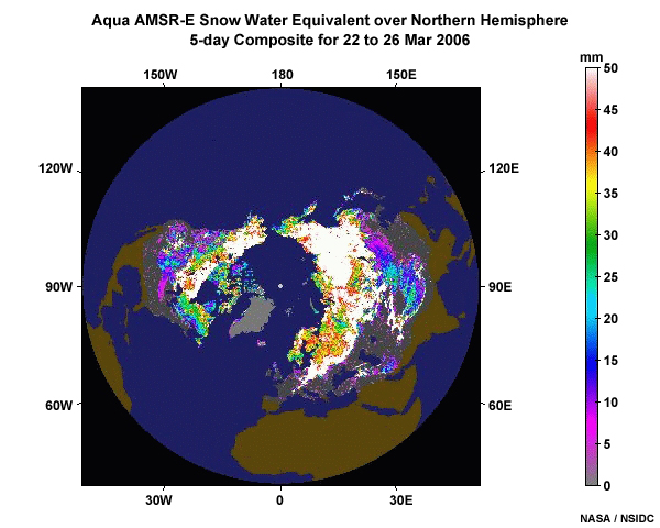
description:
Five-day snow water equivalent composite analysis from the Aqua AMSR-E microwave imager covering the Northern Hemisphere for the period ending 26 March 2006.
file name:
amsre_swe_nhem1_5day_wide.jpg
credits:
NASA / NSIDC
copyright terms:
COMET Standard Terms of Use
|
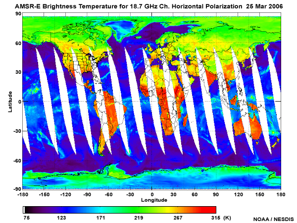
description:
AMSR-E brightness temperature global composite for the 18.7 GHz channel, horizontal polarization, taken on 25 March 2006.
file name:
amsre_tb19h.jpg
credits:
NOAA / NESDIS
copyright terms:
COMET Standard Terms of Use
|
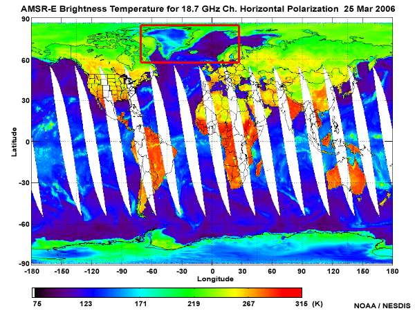
description:
AMSR-E brightness temperature global composite for the 18.7 GHz channel, horizontal polarization, taken on 25 March 2006 with an outline highlighting differences between sea ice and open water.
file name:
amsre_tb19h_seaice.jpg
credits:
NOAA / NESDIS
copyright terms:
COMET Standard Terms of Use
|

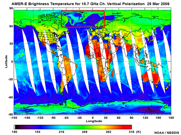
description:
AMSR-E brightness temperature global composite for the 18.7 GHz channel, horizontal polarization, taken on 25 March 2006.
file name:
amsre_tb19v.jpg
credits:
NOAA / NESDIS
copyright terms:
COMET Standard Terms of Use
|

description:
AMSR-E brightness temperature global composite for the 18.7 GHz channel, horizontal polarization, taken on 25 March 2006, with two areas outlined, one covering open ocean and the other sea ice.
file name:
amsre_tb19v_question.jpg
credits:
NOAA / NESDIS
copyright terms:
COMET Standard Terms of Use
|
description:
AMSR-E brightness temperature global composite for the 18.7 GHz channel, horizontal polarization, taken on 25 March 2006 with an outline highlighting differences between sea ice and open water.
file name:
amsre_tb19v_seaice.jpg
credits:
NOAA / NESDIS
copyright terms:
COMET Standard Terms of Use
|
description:
AMSR-E global weekly SST composite ending on 14 July, 2007.
file name:
amsre_weekly_sst_14jul07.jpg
credits:
Remote Sensing Systems
copyright terms:
COMET Standard Terms of Use
|

description:
AMSR-E global weekly SST composite ending on 14 July, 2007 with box highlighting the East Pacific equatorial current.
file name:
amsre_weekly_sst_14jul07_scgrab.jpg
credits:
Remote Sensing Systems
copyright terms:
COMET Standard Terms of Use
|
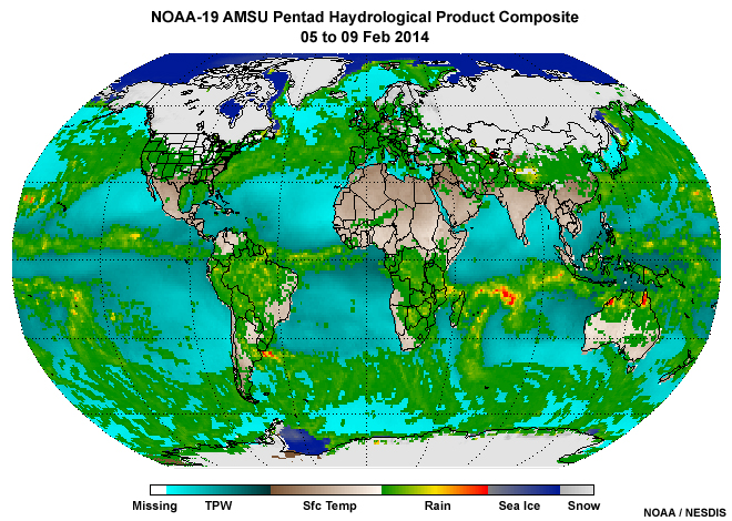
description:
NOAA-19 pentad average microwave product composite from 05 to 09 February 2014.
file name:
amsu_global_ptd_comp_09feb2014_wide.jpg
credits:
NOAA / NESDIS
copyright terms:
COMET Standard Terms of Use
|
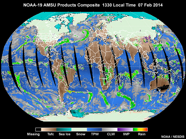
description:
NOAA-19 AMSU global microwave products composite derived from ascending (early afternoon) orbits valid around 1330 local standard time on 07 February 2014.
file name:
amsu_global_seaice_07feb14.jpg
credits:
NOAA / NESDIS
copyright terms:
COMET Standard Terms of Use
|
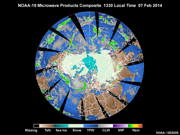
description:
NOAA-19 AMSU microwave products composite for the Northern Hemisphere, shown from a polar stereographic perspective, derived from ascending (early afternoon) orbits valid 1330 local standard time on February 07, 2014.
file name:
amsu_nh_seaice_07feb14.jpg
credits:
NOAA / NESDIS
copyright terms:
COMET Standard Terms of Use
|
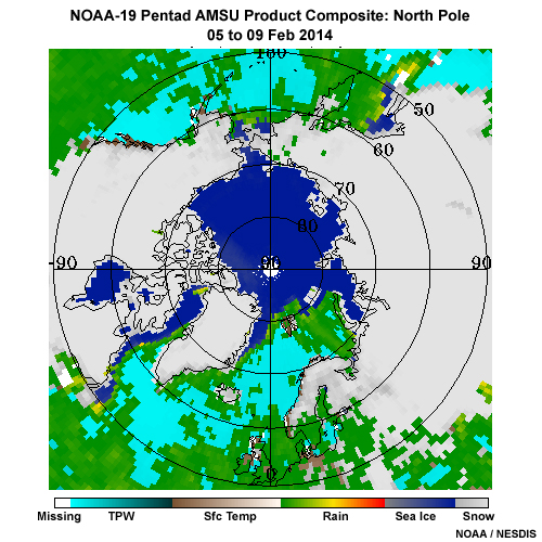
description:
NOAA-19 pentad average microwave product composite covering the North Polar Region from 05 to 09 February 2014.
file name:
amsu_np_ptd_comp_09feb2014.jpg
credits:
NOAA / NESDIS
copyright terms:
COMET Standard Terms of Use
|
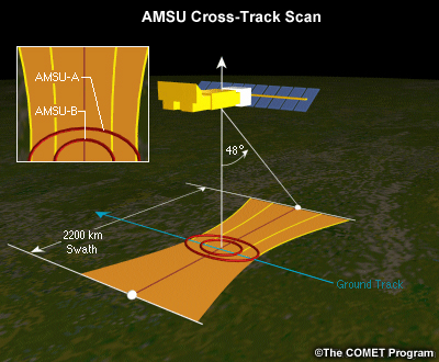
description:
Illustration of AMSU cross-track scan geometry on board the NOAA and Metop polar-orbiting spacecraft.
file name:
amsu_scan.jpg
credits:
©The COMET Program
copyright terms:
COMET Standard Terms of Use
|
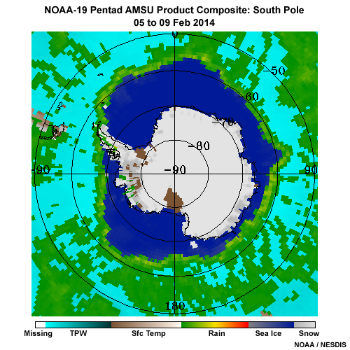
description:
NOAA-19 pentad average microwave product composite covering the South Polar Region from 05 to 09 February 2014.
file name:
amsu_sp_ptd_comp_09feb2014.jpg
credits:
NOAA / NESDIS
copyright terms:
COMET Standard Terms of Use
|
view loop
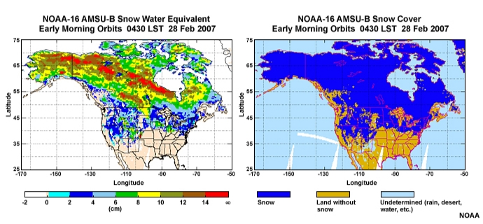
description:
Animation showing NOAA-16 microwave AMSU-B snow water equivalent and snow cover over North America for a seven day period from 28 February to 6 March, 2007 as a snow storm crosses the northern tier of the U.S..
file name:
amsub_swe_snowcov_2panel_loop_0001.htm
credits:
NOAA
copyright terms:
COMET Standard Terms of Use
|
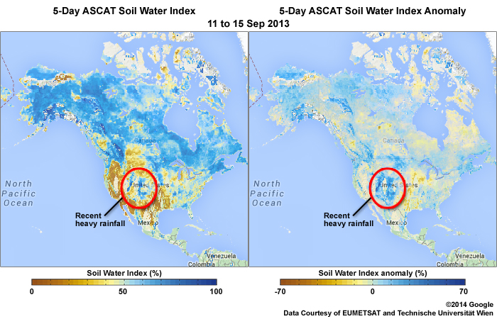
description:
Metop ASCAT Scatterometer Soil Water Index (SWI) and Anomaly products over North America for the 5-day period from 11 to 15 September 2013 showing more moist soil conditions over portions of the Great Plains regions following several days of heavy rainfall.
file name:
ascat_swi_anom_15sep2013.jpg
credits:
©2014 Google Data Courtesy of EUMETSAT and Technische Universitt Wien
copyright terms:
COMET Standard Terms of Use
|
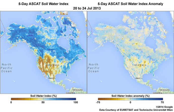
description:
Metop ASCAT Scatterometer Soil Water Index (SWI) and Anomaly products over North America for the 5-day period from 20 to 24 July 2013 showing dry conditions over much of the western two thirds of the U.S.
file name:
ascat_swi_anom_24jul2013.jpg
credits:
©2014 Google Data Courtesy of EUMETSAT and Technische Universitt Wien
copyright terms:
COMET Standard Terms of Use
|
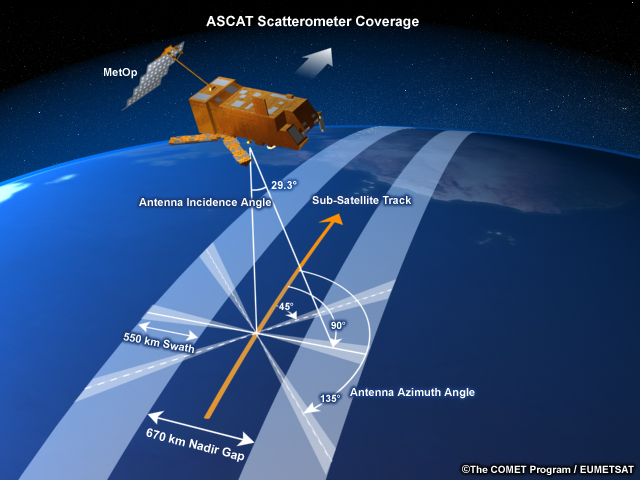
description:
Illustration of Metop ASCAT Scatterometer coverage.
file name:
ascat3d.jpg
credits:
©The COMET Program / EUMETSAT
copyright terms:
COMET Standard Terms of Use
|
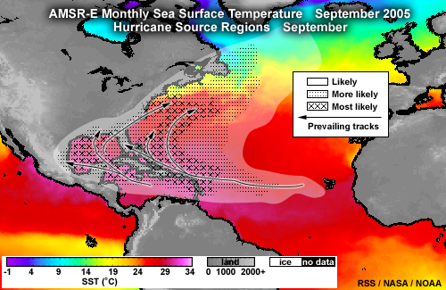
description:
Hurricane source regions in September with prevailing tracks and AMSR-E September 2005 monthly sea surface temperature.
file name:
atl_sst_hurr_sep.jpg
credits:
RSS / NASA / NOAA
copyright terms:
COMET Standard Terms of Use
|
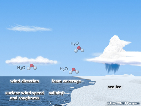
description:
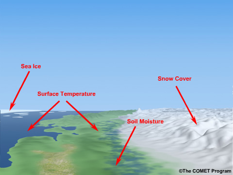
Depiction of open sea with relatively smooth surface, clouds, a few water vapor molecules, and some sea ice with annotations highlighting open ocean factors that influence emitted microwave radiation.
file name:
atmos_sea_annotations_sm.jpg
credits:
©The COMET Program
copyright terms:
COMET Standard Terms of Use
|
description:
Depiction of open sea with relatively smooth surface, clouds, and showing a few water vapor molecules.
file name:
atmos_sea_clouds_sm.jpg
credits:
©The COMET Program
copyright terms:
COMET Standard Terms of Use
|
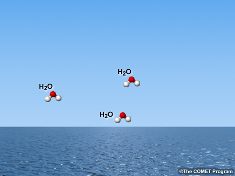
description:
Depiction of open sea with relatively smooth surface, no clouds, showing a few water vapor molecules.
file name:
atmos_sea_h2o_sm.jpg
credits:
©The COMET Program
copyright terms:
COMET Standard Terms of Use
|
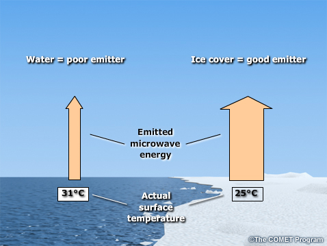
description:
Depiction of an ocean scene without cloud cover showing the difference in microwave emission between an open water surface and sea ice.
file name:
atmos_sea_ice_sm_scgrab2.jpg
credits:
©The COMET Program
copyright terms:
COMET Standard Terms of Use
|
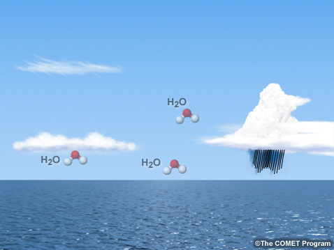
description:
Depiction of open sea with relatively smooth surface, clouds, precipitation, and showing a few water vapor molecules.
file name:
atmos_sea_precip_sm.jpg
credits:
©The COMET Program
copyright terms:
COMET Standard Terms of Use
|

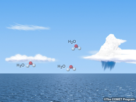
description:
Depiction of open sea with relatively smooth surface, clouds, a few water vapor molecules, and some sea ice.
file name:
atmos_sea_seaice_sm.jpg
credits:
©The COMET Program
copyright terms:
COMET Standard Terms of Use
|
description:
Soil moisture impact on mesoscale numerical modeling of heavy rainfall event and flooding for the Buffalo Creek Colorado basin burn area, 13 July 2006.
file name:
buff_creek_obs_precip_all_3.jpg
credits:
Courtesy of Fei Chen, NCAR
copyright terms:
COMET Standard Terms of Use
|
description:
Soil moisture impact on mesoscale numerical modeling of heavy rainfall event and flooding for the Buffalo Creek Colorado basin burn area, 13 July 2006.
file name:
buff_creek_obs_precip_all_3_scgrab.jpg
credits:
Courtesy of Fei Chen, NCAR
copyright terms:
COMET Standard Terms of Use
|
description:
Two-year global average cloud amount.
file name:
cloud_amount.jpg
credits:
NASA
copyright terms:
COMET Standard Terms of Use
|
description:
North America snow and ice cover product generated using data from NOAA AVHRR Vis/IR imager and surface observations.
file name:
daily_map_avhrr_obs_snowcover_22mar06.jpg
credits:
NOAA
copyright terms:
COMET Standard Terms of Use
|
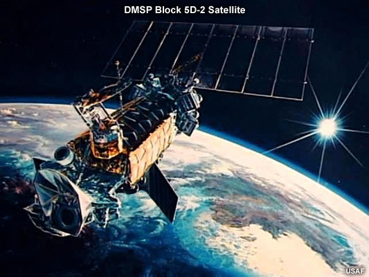
description:
Illustration of DMSP Block 5D-2 satellite in orbit.
file name:
dmsp.jpg
credits:
USAF
copyright terms:
COMET Standard Terms of Use
|
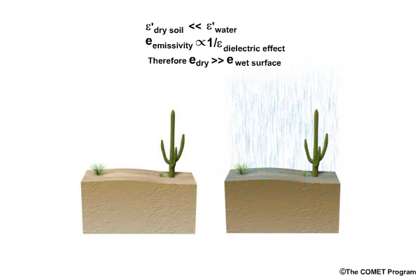
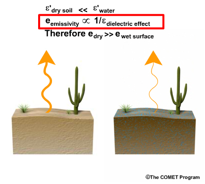
description:
Screen grab of conceptual animation showing the difference in microwave emission for dry and wet surface conditions.
file name:
dry_and_wet_emiss.jpg
credits:
©The COMET Program
copyright terms:
COMET Standard Terms of Use
|
view/save .mp4 file
description:
Conceptual animation showing the difference in microwave emission for dry and wet surface conditions.
file name:
dry_and_wet_emiss.mp4
credits:
©The COMET Program
copyright terms:
COMET Standard Terms of Use
|
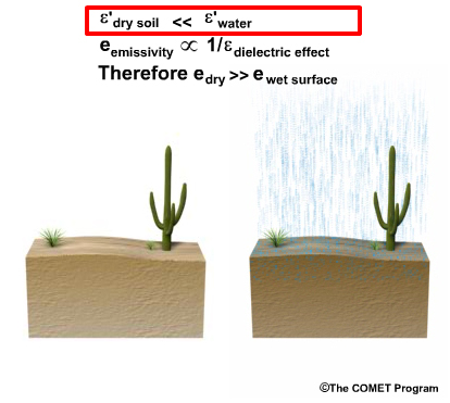
description:
Screen grab of conceptual animation showing the difference in microwave emission for dry and wet surface conditions, highlighting the dry soil vs. water dielectric constants in the top line of text.
file name:
dry_and_wet_emiss_scgrab2.jpg
credits:
©The COMET Program
copyright terms:
COMET Standard Terms of Use
|
description:
Screen grab of conceptual animation showing the difference in microwave emission for dry and wet surface conditions, highlighting the dielectric constant for water in the top line of text.
file name:
dry_and_wet_emiss_scgrab3.jpg
credits:
©The COMET Program
copyright terms:
COMET Standard Terms of Use
|
description:
Screen grab of conceptual animation showing the difference in microwave emission for dry and wet surface conditions, highlighting the relationship between emissivity and dielectric constant on the 2nd line of text.
file name:
dry_and_wet_emiss_scgrab4.jpg
credits:
©The COMET Program
copyright terms:
COMET Standard Terms of Use
|
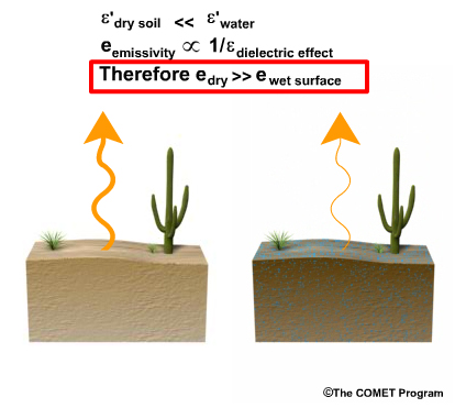
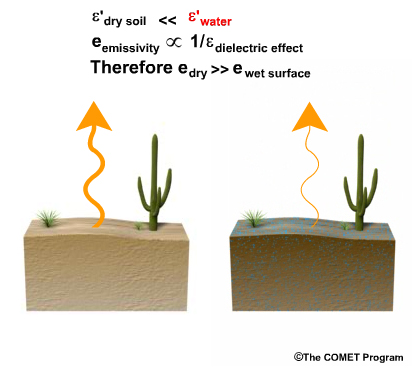
description:
Screen grab of conceptual animation showing the difference in microwave emission for dry and wet surface conditions, highlighting emissivity terms for dry vs. wet surfaces on the 3rd line of text.
file name:
dry_and_wet_emiss_scgrab5.jpg
credits:
©The COMET Program
copyright terms:
COMET Standard Terms of Use
|
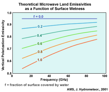
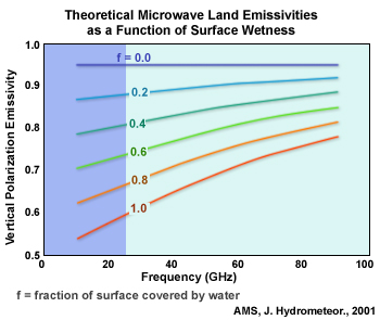
description:
Microwave emissivity for vertical polarization as a function of surface coverage by water.
file name:
emiss_vs_sfc_wetness.jpg
credits:
AMS, J. Hydrometeor., 2001
copyright terms:
COMET Standard Terms of Use
|
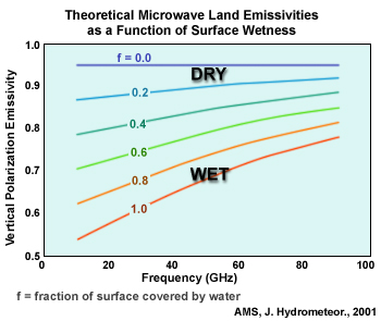
description:
Microwave emissivity for vertical polarization as a function of surface coverage by water highlighting dry vs. wet surface soil conditions.
file name:
emiss_vs_sfc_wetness_scgrab1.jpg
credits:
AMS, J. Hydrometeor., 2001
copyright terms:
COMET Standard Terms of Use
|
description:
Microwave emissivity for vertical polarization as a function of surface coverage by water highlighting the lower frequency end of the spectrum.
file name:
emiss_vs_sfc_wetness_scgrab2.jpg
credits:
AMS, J. Hydrometeor., 2001
copyright terms:
COMET Standard Terms of Use
|
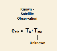
description:
Expression for surface emissivity as a function of observed satellite brightness temperature and actual (measured) surface temperture.
file name:
esfc_233.gif
credits:
none - considered general scientific knowledge
copyright terms:
COMET Standard Terms of Use
|
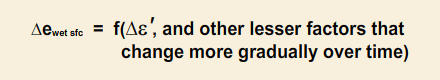
description:
Expression for changing surface emissivity as a function of changing dielectric constant for a surface with varying water content (wetness).
file name:
ewetsfc_233.gif
credits:
none - considered general scientific knowledge
copyright terms:
COMET Standard Terms of Use
|
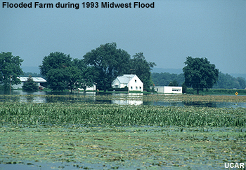
description:
Photo of a flooded farm taken during the Great Mississippi and Missouri Rivers Flood of 1993.
file name:
flooded_farm.jpg
credits:
UCAR
copyright terms:
COMET Standard Terms of Use
|
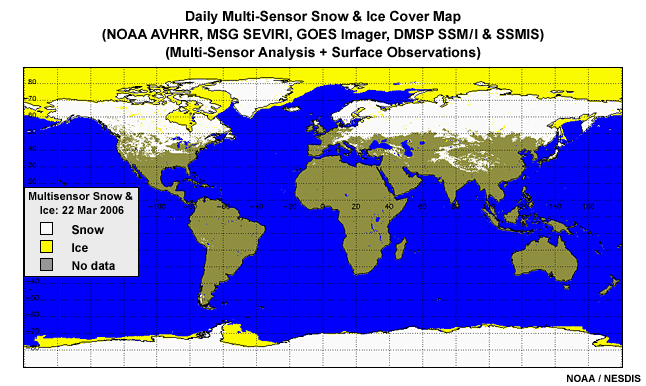
description:
NOAA global snow and ice chart generated from multisensor satellite data including visible, mid-infrared, infrared, and microwave channels for 22 March, 2006.
file name:
global_snow_ice_chart_22mar06.jpg
credits:
NOAA
copyright terms:
COMET Standard Terms of Use
|
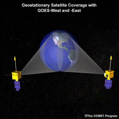
description:
Illustration depicting coverage areas over the Western Hemisphere for GOES West and East geostationary meteorological satellites.
file name:
goes_coverage.jpg
credits:
(c)The COMET Program
copyright terms:
COMET Standard Terms of Use
|
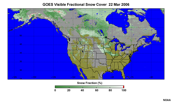
description:
Fractional snow cover product over the Northern Hemisphere generated from GOES visible data on 22 March, 2006.
file name:
goes_snow_frac_22mar06.jpg
credits:
NOAA
copyright terms:
COMET Standard Terms of Use
|
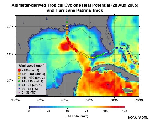
description:
Altimeter derived Tropical Cyclone Heat Potential product and hurricane Katrina Track from 28 August, 2005.
file name:
gom_tchp_katrina.jpg
credits:
NOAA / AOML
copyright terms:
COMET Standard Terms of Use
|
description:
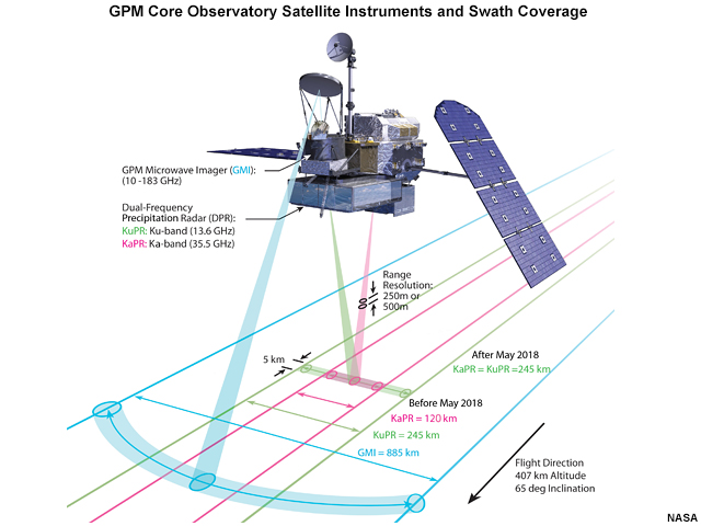
Diagram of swath coverage and scan patterns for the GPM (Global Precipitation Measurement) satellite's Microwave Imager (GMI) and Dual-Frequency Precipitation Radar (DPR) instruments on board the GPM Core Observatory launched February 2014.
file name:
gpm_swath_scan.jpg
credits:
NASA
copyright terms:
COMET Standard Terms of Use
|
|
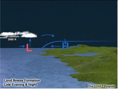
description:
Conceptual illustration of land breeze formation during the late evening and night.
file name:
land_breeze_nighttime.jpg
credits:
(c)The COMET Program
copyright terms:
COMET Standard Terms of Use
|
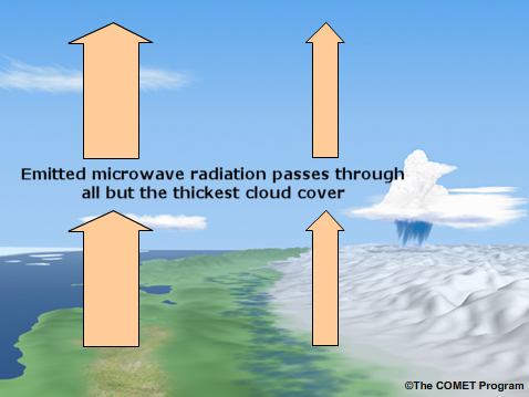
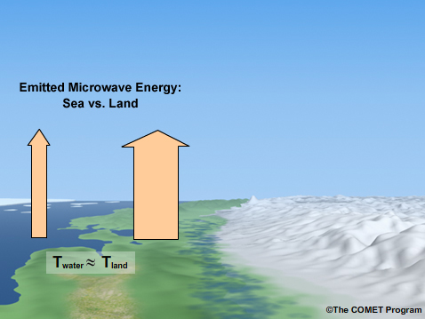
description:
Depiction of snow covered land and mountains with coastline, bare area of soil, and wet ground adjacent to snow pack with microwave radiation (arrows) passing through all but the thickest cloud cover.
file name:
land_sea_clouds2_scgrab.jpg
credits:
©The COMET Program
copyright terms:
COMET Standard Terms of Use
|

description:
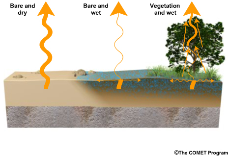
Depiction of snow covered land and mountains with coastline, bare patch of soil, and wet ground adjacent to snow pack showing microwave emissions for a dry vs. wet surfaces.
file name:
land_sea2a_scgrab.jpg
credits:
©The COMET Program
copyright terms:
COMET Standard Terms of Use
|
description:
Depiction of snow covered land and mountains with coastline, bare patch of soil, and wet ground adjacent to snow pack showing microwave emissions for a dry vs. wet surfaces.
file name:
land_sea2a_scgrab2.jpg
credits:
©The COMET Program
copyright terms:
COMET Standard Terms of Use
|
view/save .mp4 file
description:
Animation of a polar-orbiting satellite in an early morning orbit, orbiting the earth during a 24-hour period, showing both equatorial and North Pole perspectives.
file name:
leo_24hr_ani.mp4
credits:
©The COMET Program
copyright terms:
COMET Standard Terms of Use
|

description:
Illustration of the Metop polar-orbiting satellite and instruments.
file name:
metoppayload_10sep2014.jpg
credits:
© 2006 EUMETSAT
copyright terms:
COMET Standard Terms of Use
|
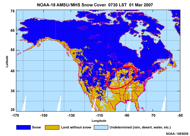
description:
NOAA-18 AMSU snow cover product over North America for 01 March 2007 with outline over the Midwest region highlighting cloud cover and precipitation contamination.
file name:
mhs_snow_na_des_01mar2007_scgrab.jpg
credits:
NOAA / NESDIS
copyright terms:
COMET Standard Terms of Use
|
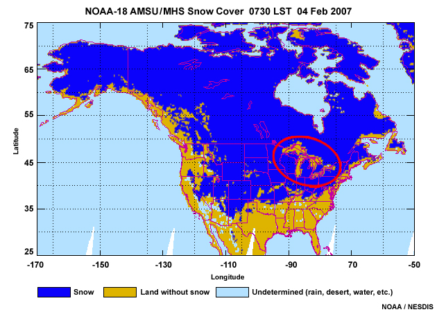
description:
NOAA-18 AMSU snow cover product over North America for 04 February 2007 with Great Lakes region outlined to illustrate coastal effects (contamination) in the product.
file name:
mhs_snow_na_des_04feb2007_scgrab.jpg
credits:
NOAA / NESDIS
copyright terms:
COMET Standard Terms of Use
|
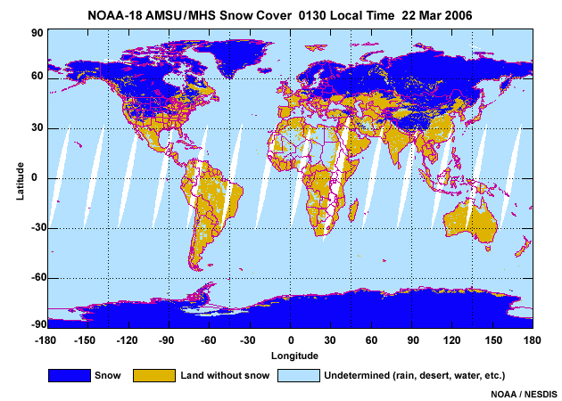
description:
NOAA-18 AMSU/MHS snow cover product over North America for 22 March 2006.
file name:
mhs_snow_na_des_22mar06.jpg
credits:
NOAA / NESDIS
copyright terms:
COMET Standard Terms of Use
|
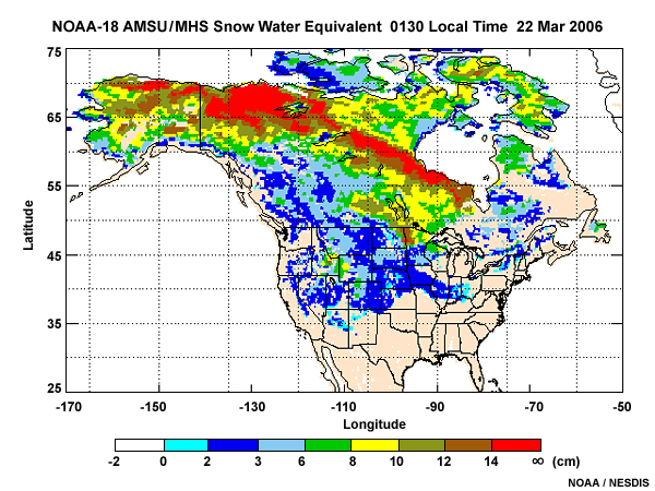
description:
NOAA-18 AMSU snow water equivalent (SWE) product over North America during nighttime hours for 22 March 2007.
file name:
mhs_swe_na_2006081_des.jpg
credits:
NOAA / NESDIS
copyright terms:
COMET Standard Terms of Use
|
description:
Depiction of snow covered land and mountains with coastline, bare patch of soil, and wet ground adjacent to snow pack.
file name:
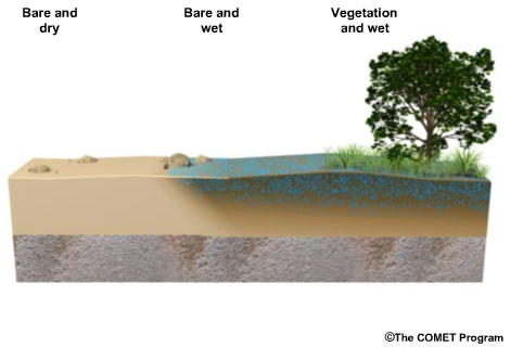
micro_background_1.jpg
credits:
©The COMET Program
copyright terms:
COMET Standard Terms of Use
|
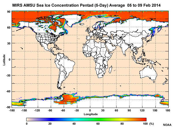
description:
NOAA-19 five-day averaged (pentad) sea ice product for 5 to 9 February, 2014.
file name:
mirs_amsu_ptd_seaice_09feb2014.jpg
credits:
NOAA
copyright terms:
COMET Standard Terms of Use
|

description:
Suomi NPP ATMS microwave sea ice concentration for ascending (midday, 1330 LST) orbits on April 3, 2014.
file name:
mirs_atms_sice_asc_03apr2014.jpg
credits:
NOAA
copyright terms:
COMET Standard Terms of Use
|
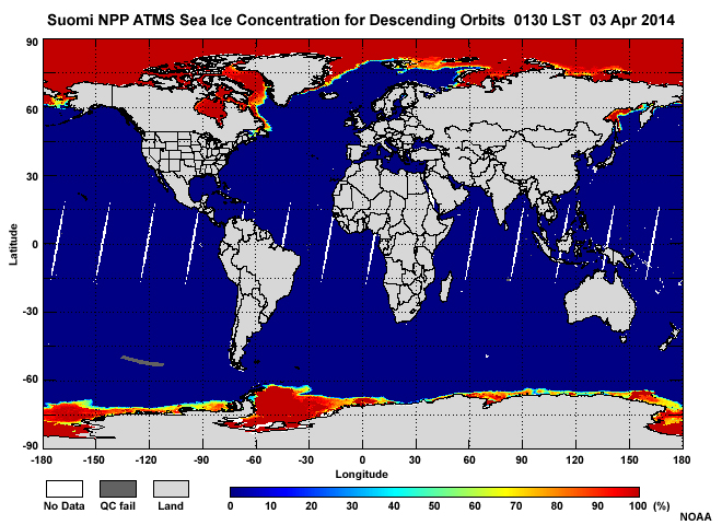
description:
Suomi NPP ATMS microwave sea ice concentration for descending (nighttime, 1330 LST) orbits on April 3, 2014.
file name:
mirs_atms_sice_dsc_03apr2014.jpg
credits:
NOAA
copyright terms:
COMET Standard Terms of Use
|
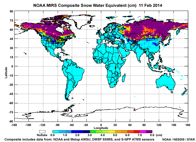
description:
Snow water equivalent composite product from NOAA's Microwave Integrated Retrieval System (MIRS) that includes observations from NOAA and Metop AMSU, DMSP SSMIS, and S-NPP ATMS microwave instruments produced for February 11, 2014.
file name:
mirs_swe_nam_11feb14.jpg
credits:
NOAA / NESDIS / STAR
copyright terms:
COMET Standard Terms of Use
|
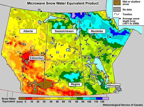
description:
Microwave snow water equivalent product produced by the Meteorological Service of Canada and valid on 22 March, 2006.
file name:
msc_swe_060322e.jpg
credits:
Meteorological Service of Canada
copyright terms:
COMET Standard Terms of Use
|
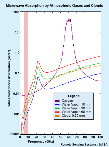
description:
A graph plotting atmospheric absorption for oxygen, water vapor, and as a function of microwave frequency between 0 and 100 GHz.
file name:
mw_atmos_atten_scgrab1.jpg
credits:
Remote Sensing Systems / NASA
copyright terms:
COMET Standard Terms of Use
|

description:
A graph plotting atmospheric absorption for oxygen, water vapor, and as a function of microwave frequency between 0 and 100 GHz.
file name:
mw_atmos_atten_scgrab2.jpg
credits:
Remote Sensing Systems / NASA
copyright terms:
COMET Standard Terms of Use
|
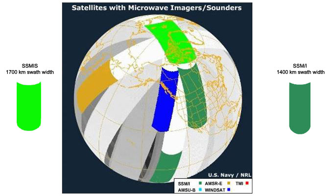
description:
Illustration of swath coverages for various polar-orbiting satellites carrying passive microwave instruments.
file name:
mw_instrument_orbits_dmsp_s7p1_1p.jpg
credits:
U.S. Navy / NRL
copyright terms:
COMET Standard Terms of Use
|
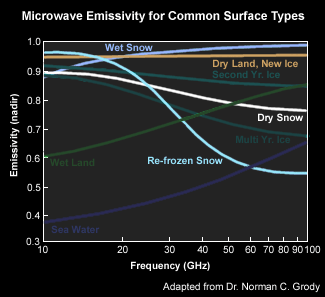
description:
Microwave emissivity for various surface types including land, snow, sea ice, and sea water, with emphasis on snow types.
file name:
mw_sfc_emiss_snow1.gif
credits:
Adapted from Dr. Norman C. Grody
copyright terms:
COMET Standard Terms of Use
|

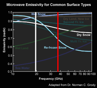
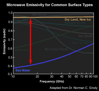
description:
Microwave emissivity for various surface types including land, snow, sea ice, and sea water, with emphasis on snow types, and differences between dry land, dry snow and re-frozen snow at 37 GHz.
file name:
mw_sfc_emiss_snow1_scgrab.jpg
credits:
Adapted from Dr. Norman C. Grody
copyright terms:
COMET Standard Terms of Use
|
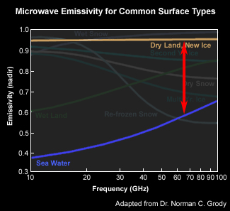
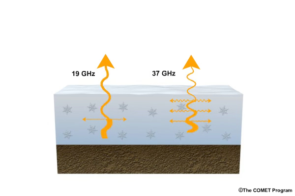
description:
Microwave emissivity for various surface types including land, snow, sea ice, and sea water, highlighting the 19 and 37 GHz channels used for characterizing snowpack conditions.
file name:
mw_sfc_emiss_snow2_scgrab.jpg
credits:
Adapted from Dr. Norman C. Grody
copyright terms:
COMET Standard Terms of Use
|
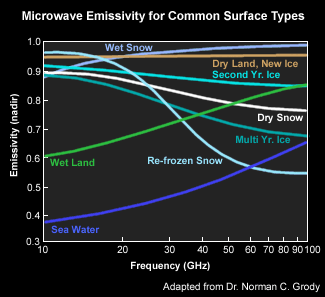
description:
Microwave emissivity for various surface types including land, snow, sea ice, and sea water.
file name:
mw_sfc_emiss1.gif
credits:
Adapted from Dr. Norman C. Grody
copyright terms:
COMET Standard Terms of Use
|
description:
Microwave emissivity for various surface types including land, snow, sea ice, and sea water.
file name:
mw_sfc_emiss2.jpg
credits:
Adapted from Dr. Norman C. Grody
copyright terms:
COMET Standard Terms of Use
|
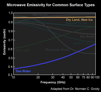
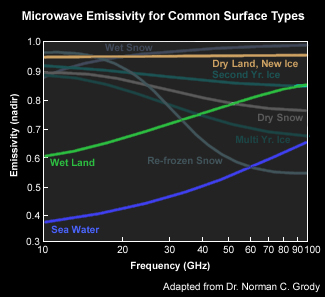
description:
Microwave emissivity for various surface types, highlighting dry land and new ice (tan), and sea water emissivity curves (blue).
file name:
mw_sfc_emiss3.jpg
credits:
Adapted from Dr. Norman C. Grody
copyright terms:
COMET Standard Terms of Use
|
description:
Microwave emissivity for various surface types, highlighting dry land and new ice (tan), and sea water emissivity curves (blue).
file name:
mw_sfc_emiss3_scgrab1.jpg
credits:
Adapted from Dr. Norman C. Grody
copyright terms:
COMET Standard Terms of Use
|
description:
Microwave emissivity for various surface types, highlighting dry land and new ice (tan), and sea water emissivity curves (blue).
file name:
mw_sfc_emiss3_scgrab2.jpg
credits:
Adapted from Dr. Norman C. Grody
copyright terms:
COMET Standard Terms of Use
|
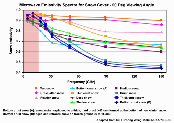
description:
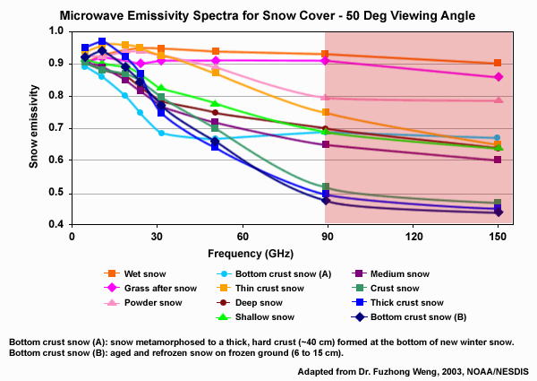
Microwave emissivity spectra between 4.9 and 150 GHz for 11 different snow cover types highlighting frequencies below 20 GHz.
file name:
mw_snow_espectra12_scgrab1.jpg
credits:
Adapted from Dr. Fuzhong Weng, 2003, NOAA/NESDIS
copyright terms:
COMET Standard Terms of Use
|
description:
Microwave emissivity spectra between 4.9 and 150 GHz for 11 different snow cover types highlighting frequencies greater than 89 GHz.
file name:
mw_snow_espectra12_scgrab2.jpg
credits:
Adapted from Dr. Fuzhong Weng, 2003, NOAA/NESDIS
copyright terms:
COMET Standard Terms of Use
|
description:
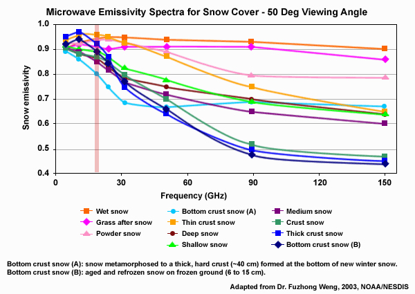
Microwave emissivity spectra between 4.9 and 150 GHz for 11 different snow cover types highlighting the 22 GHz frequency band.
file name:
mw_snow_espectra12_scgrab3.jpg
credits:
Adapted from Dr. Fuzhong Weng, 2003, NOAA/NESDIS
copyright terms:
COMET Standard Terms of Use
|
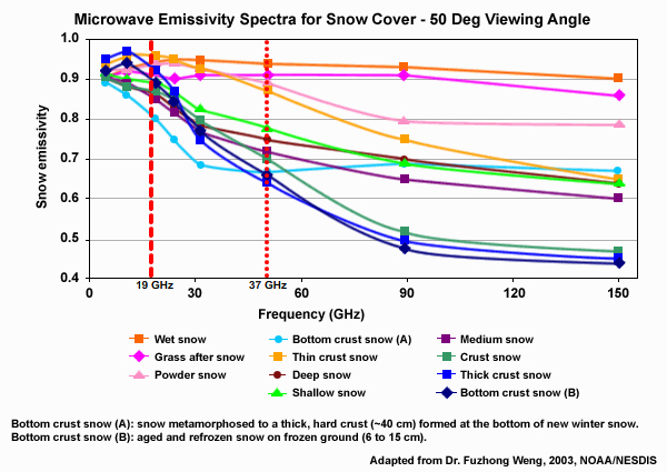
description:
Microwave emissivity spectra between 4.9 and 150 GHz for 11 different snow cover types highlighting frequencies at 19 and 37 GHz used for determining snowpack properties.
file name:
mw_snow_espectra12_scgrab4.jpg
credits:
Adapted from Dr. Fuzhong Weng, 2003, NOAA/NESDIS
copyright terms:
COMET Standard Terms of Use
|
view/save .mp4 file
description:
Conceptual animation of microwave soil penetration as a function of soil moisture content at 10 GHz (3 cm wavelength).
file name:
mw_soil_penetration.mp4
credits:
©The COMET Program
copyright terms:
COMET Standard Terms of Use
|
description:
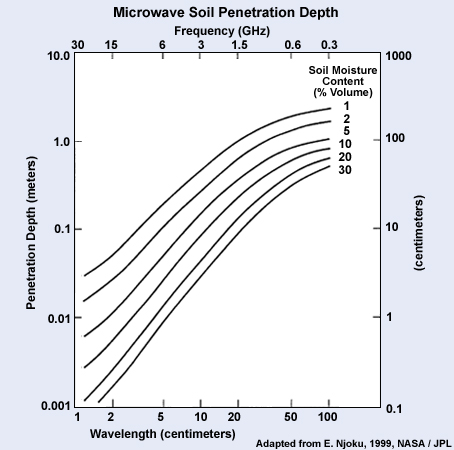
A plot showing microwave soil penetration depth as a function of microwave frequency and soil moisture content.
file name:
mw_soil_penetration_vs_wetness.jpg
credits:
Adapted from E. Njoku, 1999, NASA / JPL
copyright terms:
COMET Standard Terms of Use
|
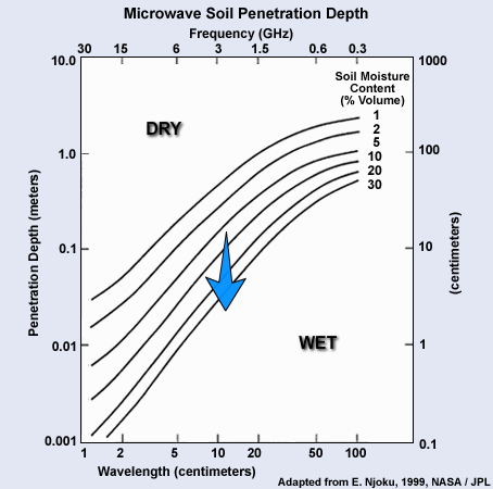
description:
A plot showing microwave soil penetration depth as a function of microwave frequency and soil moisture content with dry and wet soil regions labeled.
file name:
mw_soil_penetration_vs_wetness_scgrab1.jpg
credits:
Adapted from E. Njoku, 1999, NASA / JPL
copyright terms:
COMET Standard Terms of Use
|
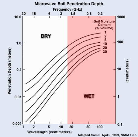
description:
A plot showing microwave soil penetration depth as a function of microwave frequency and soil moisture content with wet region (right half of plot) highlighted.
file name:
mw_soil_penetration_vs_wetness_scgrab2.jpg
credits:
Adapted from E. Njoku, 1999, NASA / JPL
copyright terms:
COMET Standard Terms of Use
|

description:
Microwave portion of the electromagnetic spectrum showing atmospheric transmittance as a function of frequency, with 6.9 GHz channel region highlighted.
file name:
mw_spectrum_scgrab1.jpg
credits:
©The COMET Program
copyright terms:
COMET Standard Terms of Use
|
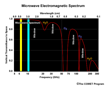
description:
Microwave portion of the electromagnetic spectrum showing atmospheric transmittance as a function of frequency, with 10.7 GHz channel region highlighted.
file name:
mw_spectrum_scgrab2.jpg
credits:
©The COMET Program
copyright terms:
COMET Standard Terms of Use
|
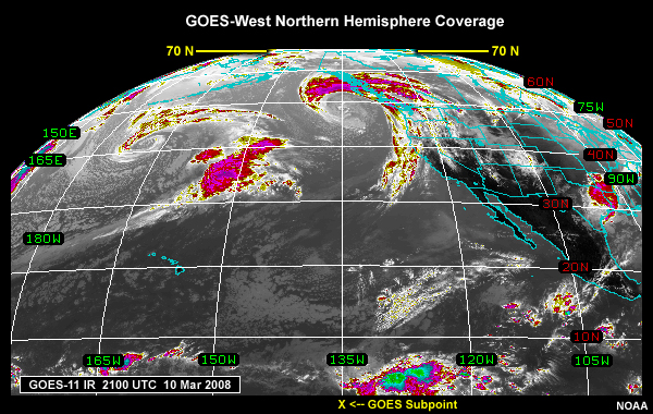
description:
GOES-West infrared image showing coverage over the Northern Hemisphere from a satellite position at 135 degrees west longitude.
file name:
nhem_goesw_ir.jpg
credits:
NOAA
copyright terms:
COMET Standard Terms of Use
|
description:
NOAA Northern Hemisphere snow and ice chart generated from multisensor satellite data including visible, mid-infrared, infrared, and microwave channels for 22 March, 2006.
file name:
nhem_snow_ice_chart_22mar06_lg.jpg
credits:
NOAA
copyright terms:
COMET Standard Terms of Use
|
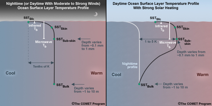
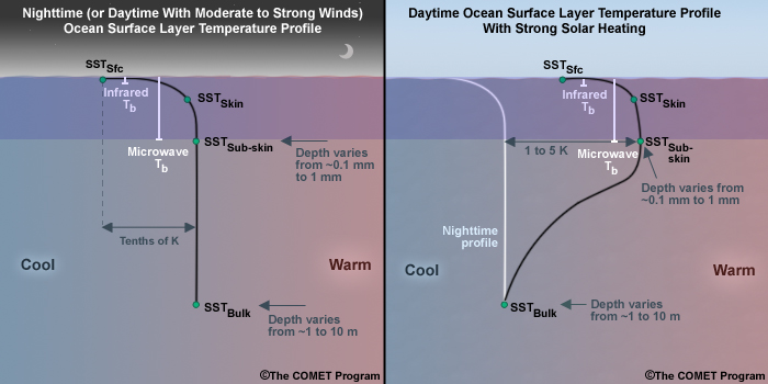
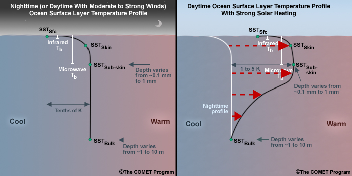
description:
Two-panel plot showing nighttime (or daytime with moderate to strong winds) ocean temperature profile within the upper portion (1 to 10m) of the ocean's surface mixed layer, and daytime upper ocean temperature profile with strong heating.
file name:
night_daytime_ocean_ml_profile_2panel.jpg
credits:
(c)The COMET Program
copyright terms:
COMET Standard Terms of Use
|

description:
Two-panel plot showing nighttime (or daytime with moderate to strong winds) ocean temperature profile within the upper portion (1 to 10m) of the ocean's surface mixed layer, and daytime upper ocean temperature profile with strong heating, with top infrared sensed layer highlighted.
file name:
night_daytime_ocean_ml_profile_2panel_ann1.jpg
credits:
(c)The COMET Program
copyright terms:
COMET Standard Terms of Use
|
description:
Two-panel plot showing nighttime (or daytime with moderate to strong winds) ocean temperature profile within the upper portion (1 to 10m) of the ocean's surface mixed layer, and daytime upper ocean temperature profile with strong heating, with top microwave sensed layer highlighted.
file name:
night_daytime_ocean_ml_profile_2panel_ann2.jpg
credits:
(c)The COMET Program
copyright terms:
COMET Standard Terms of Use
|
description:
Two-panel plot showing nighttime (or daytime with moderate to strong winds) ocean temperature profile within the upper portion (1 to 10m) of the ocean's surface mixed layer, and daytime upper ocean temperature profile with strong heating, with warming temperature profile highlighted on daytime plot.
file name:
night_daytime_ocean_ml_profile_2panel_ann3.jpg
credits:
(c)The COMET Program
copyright terms:
COMET Standard Terms of Use
|
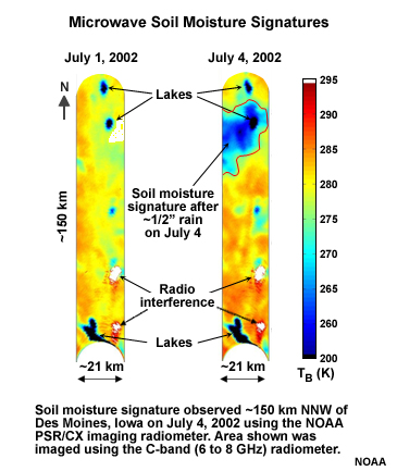
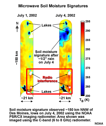
description:
Microwave soil moisture, lake and radio interference signatures observed using C-band 6-8 GHz radiometer component of the NOAA PSR/CX imaging radiometer.
file name:
noaa_mw_rad.jpg
credits:
NOAA
copyright terms:
COMET Standard Terms of Use
|

description:
Microwave soil moisture, lake and radio interference signatures observed using C-band 6-8 GHz radiometer component of the NOAA PSR/CX imaging radiometer, with outline highlighting wet ground signatures.
file name:
noaa_mw_rad_scgrab1.jpg
credits:
NOAA
copyright terms:
COMET Standard Terms of Use
|
description:
Microwave soil moisture, lake and radio interference signatures observed using C-band 6-8 GHz radiometer component of the NOAA PSR/CX imaging radiometer, with outline highlighting ground-based radio interference signatures.
file name:
noaa_mw_rad_scgrab2.jpg
credits:
NOAA
copyright terms:
COMET Standard Terms of Use
|
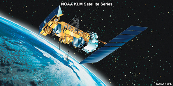
description:
Illustration of the NOAA KLM polar-orbiting satellite in orbit.
file name:
noaa-18.jpg
credits:
NASA / JPL
copyright terms:
COMET Standard Terms of Use
|
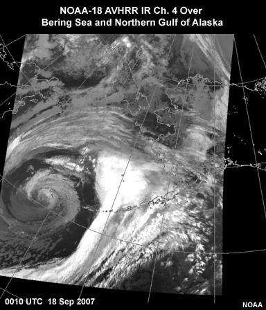
description:
NOAA-18 infrared image over the Bering Sea and northern Gulf of Alaska taken at 0010 UTC on 18 September, 2007.
file name:
noaa18_ir4_0010utc_18sep07.jpg
credits:
NOAA
copyright terms:
COMET Standard Terms of Use
|
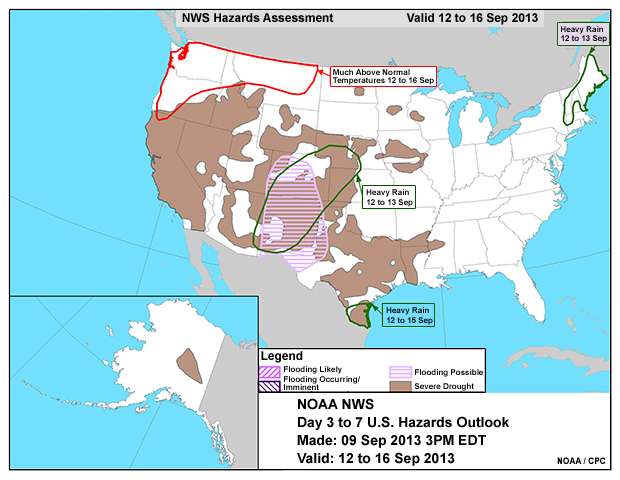
description:
NWS daily threats composite analysis for the contiguous U.S. and Alaska depicting the potential for weather-related natural hazards from 12 to 16 September, 2013.
file name:
nws_threats_composite_09sep13.jpg
credits:
NOAA / CPC
copyright terms:
COMET Standard Terms of Use
|

description:
NOAA drought severity index by climate division over the U.S. valid for the weekly period ending 23 June 2007.
file name:
palmer_index_23jun07.jpg
credits:
NOAA / CPC
copyright terms:
COMET Standard Terms of Use
|
|
|
|
|
|
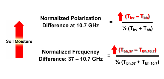
description:
Two expressions; the normalized polarization difference at 10.7 GHz (left side) and the normalized frequency difference, 37 minus 10.7 GHz (right side), used to derive soil moisture from AMSR-2 observations.
file name:
polratio_combined_243.jpg
credits:
no credit, general scientific knowledge
copyright terms:
COMET Standard Terms of Use
|
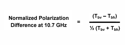
description:
The normalized polarization difference at 10.7 GHz used to derive soil moisture from AMSR-2 observations.
file name:
polratio1_243.gif
credits:
no credit, general scientific knowledge
copyright terms:
COMET Standard Terms of Use
|
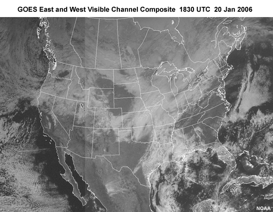
description:
GOES East and West visible channel composite image taken at 1830 UTC on 20 January, 2006.
file name:
sat_vis_20jan06.jpg
credits:
NOAA
copyright terms:
COMET Standard Terms of Use
|
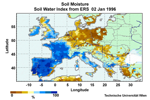
description:
ERS Scatterometer soil moisture product over Europe for 2 January 1996 showing moist conditions over Western Europe and dry conditions over Eastern Europe.
file name:
scatsoilm1.jpg
credits:
Technische Universitt Wien
copyright terms:
COMET Standard Terms of Use
|
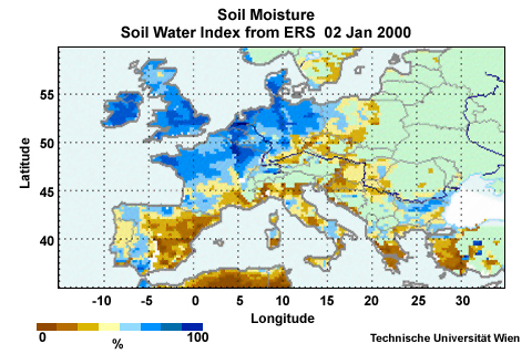
description:
ERS Scatterometer soil moisture product over Europe for 2 January 2000 showing dry conditions over Southern Europe and moisture conditions over Northern Europe.
file name:
scatsoilm2.jpg
credits:
Technische Universitt Wien
copyright terms:
COMET Standard Terms of Use
|
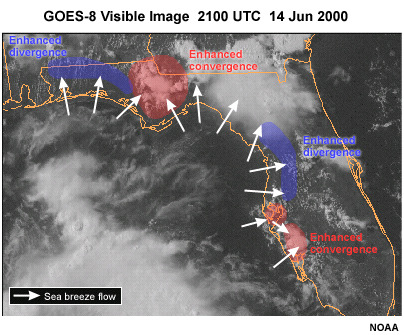
description:
GOES visible image of sea breezes interacting with Florida coastlines, showing the importance of both areas of enhanced convergence and enhanced divergence due to coastline shape.
file name:
sea_breeze_coastline_impacts.jpg
credits:
(c)The COMET Program
copyright terms:
COMET Standard Terms of Use
|
description:
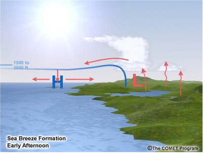
Conceptual illustration of sea breeze formation during the early afternoon hours.
file name:
sea_breeze_early_pm.jpg
credits:
(c)The COMET Program
copyright terms:
COMET Standard Terms of Use
|

view loop
description:
Conceptual illustrations of sea breeze formation during the early afternoon and early evening hours of the day.
file name:
sea_land_breeze_loop_0001.htm
credits:
(c)The COMET Program
copyright terms:
COMET Standard Terms of Use
|
description:
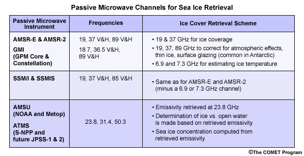
Table summarizing passive microwave instruments and channels commonly used by sea ice retrieval algorithms.
file name:
seaice_channel_table.gif
credits:
©The COMET Program
copyright terms:
COMET Standard Terms of Use
|
description:
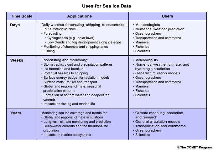
Current uses and users of sea ice data.
file name:
seaice_data_uses.gif
credits:
©The COMET Program
copyright terms:
COMET Standard Terms of Use
|
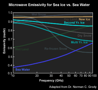
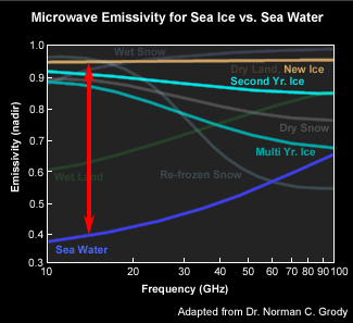
description:
Microwave emissivity for various surface types highlighting sea ice and sea water curves.
file name:
seaice_emissivity1.gif
credits:
Adapted from Dr. Norman C. Grody
copyright terms:
COMET Standard Terms of Use
|
description:
Microwave emissivity for various surface types highlighting sea ice and sea water curves.
file name:
seaice_emissivity1_scgrab.jpg
credits:
Adapted from Dr. Norman C. Grody
copyright terms:
COMET Standard Terms of Use
|
|
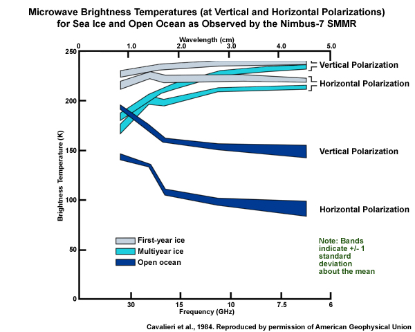
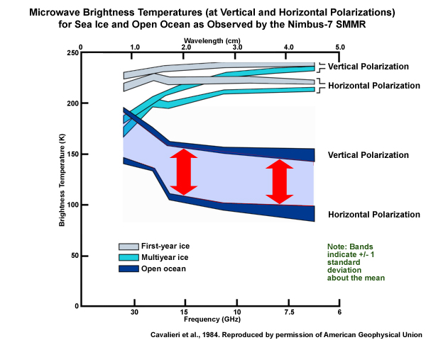
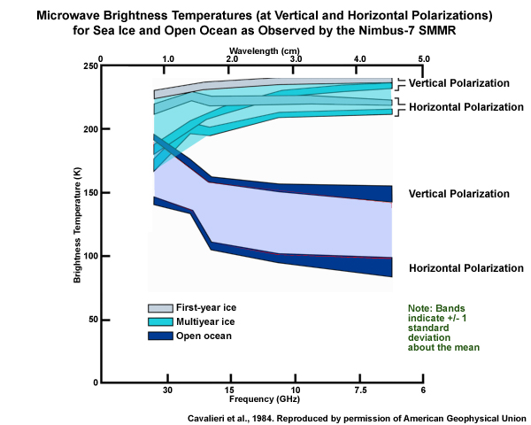
description:
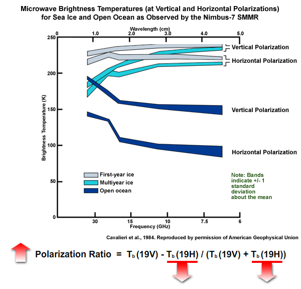
Microwave brightness temperatures of first-year and multi-year sea ice and open ocean as observed by the Nimbus-7 SMMR (Scanning Multi-channel Microwave Radiometer). Shaded bands indicate plus or minus one standard deviation about the mean.
file name:
seaice_mw_bt_spectra_v2.jpg
credits:
Cavalieri et al. 1984. Reproduced by permission of American Geophysical Union
copyright terms:
COMET Standard Terms of Use
|
description:
Microwave brightness temperatures of first-year and multi-year sea ice and open ocean as observed by the Nimbus-7 SMMR (Scanning Multi-channel Microwave Radiometer). Shaded bands indicate plus or minus one standard deviation about the mean.
file name:
seaice_mw_bt_spectra_v2_scgrab1.jpg
credits:
Cavalieri et al. 1984. Reproduced by permission of American Geophysical Union
copyright terms:
COMET Standard Terms of Use
|
description:
Microwave brightness temperatures of first-year and multi-year sea ice and open ocean as observed by the Nimbus-7 SMMR (Scanning Multi-channel Microwave Radiometer). Shaded bands indicate plus or minus one standard deviation about the mean.
file name:
seaice_mw_bt_spectra_v2_scgrab2.jpg
credits:
Cavalieri et al. 1984. Reproduced by permission of American Geophysical Union
copyright terms:
COMET Standard Terms of Use
|
description:
Microwave brightness temperatures of first-year and multi-year sea ice and open ocean as observed by the Nimbus-7 SMMR (Scanning Multi-channel Microwave Radiometer). Shaded bands indicate plus or minus one standard deviation about the mean.
file name:
seaice_mw_bt_spectra_v2_scgrab3a.jpg
credits:
Cavalieri et al. 1984. Reproduced by permission of American Geophysical Union
copyright terms:
COMET Standard Terms of Use
|
description:
Microwave brightness temperatures of first-year and multi-year sea ice and open ocean as observed by the Nimbus-7 SMMR (Scanning Multi-channel Microwave Radiometer). Shaded bands indicate plus or minus one standard deviation about the mean.
file name:
seaice_mw_bt_spectra_v2_scgrab3b.jpg
credits:
Cavalieri et al. 1984. Reproduced by permission of American Geophysical Union
copyright terms:
COMET Standard Terms of Use
|
description:
Microwave brightness temperatures of first-year and multi-year sea ice and open ocean as observed by the Nimbus-7 SMMR (Scanning Multi-channel Microwave Radiometer). Shaded bands indicate plus or minus one standard deviation about the mean.
file name:
seaice_mw_bt_spectra_v2_scgrab4.jpg
credits:
Cavalieri et al. 1984. Reproduced by permission of American Geophysical Union
copyright terms:
COMET Standard Terms of Use
|
description:
Microwave brightness temperatures of first-year and multi-year sea ice and open ocean as observed by the Nimbus-7 SMMR (Scanning Multi-channel Microwave Radiometer). Shaded bands indicate plus or minus one standard deviation about the mean.
file name:
seaice_mw_bt_spectra_v2_scgrab5.jpg
credits:
Cavalieri et al. 1984. Reproduced by permission of American Geophysical Union
copyright terms:
COMET Standard Terms of Use
|
description:
Microwave brightness temperatures of first-year and multi-year sea ice and open ocean as observed by the Nimbus-7 SMMR (Scanning Multi-channel Microwave Radiometer). Shaded bands indicate plus or minus one standard deviation about the mean.
file name:
seaice_mw_bt_spectra_v2_scgrab6.jpg
credits:
Cavalieri et al. 1984. Reproduced by permission of American Geophysical Union
copyright terms:
COMET Standard Terms of Use
|
|
|
|
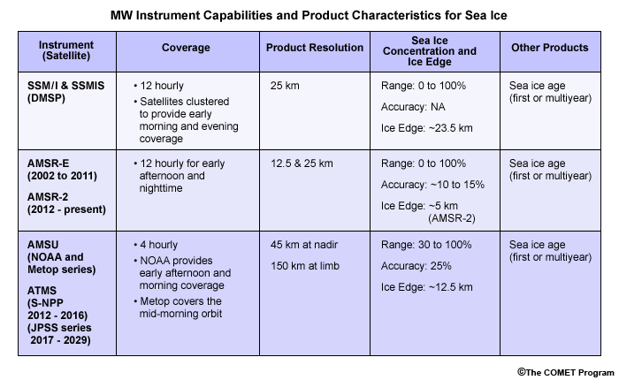
description:
Table summarizing passive microwave instrument capabilities and product characteristics for sea ice.
file name:
seaice_prod_table.gif
credits:
©The COMET Program
copyright terms:
COMET Standard Terms of Use
|
description:
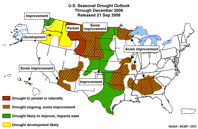
U.S. Seasonal Drought Outlook product valid from 21 September through December 2006.
file name:
season_drought_outlook_21sep06.jpg
credits:
NOAA / NWS / NCEP
copyright terms:
COMET Standard Terms of Use
|
description:
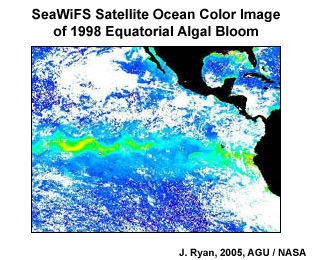
SeaWiFS satellite image composite of a 1998 algal bloom over the eastern equatorial Pacific.
file name:
seawifs_pacific_algal_bloom.jpg
credits:
J. Ryan, 2005, AGU / NASA
copyright terms:
COMET Standard Terms of Use
|
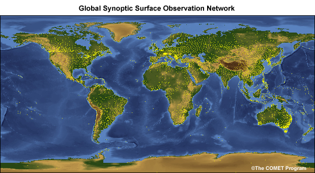
description:
Depiction of the global surface synoptic observation network consisting of some 4000 land stations.
file name:
sfc_obs_network.jpg
credits:
©The COMET Program
copyright terms:
COMET Standard Terms of Use
|

description:
U.S. soil moisture anomaly change from 30 June to 11 September 2006 as computed by NOAA-NWS-NCEP.
file name:
sm_anomaly_change_11sep06.jpg
credits:
NOAA / NWS / NCEP
copyright terms:
COMET Standard Terms of Use
|
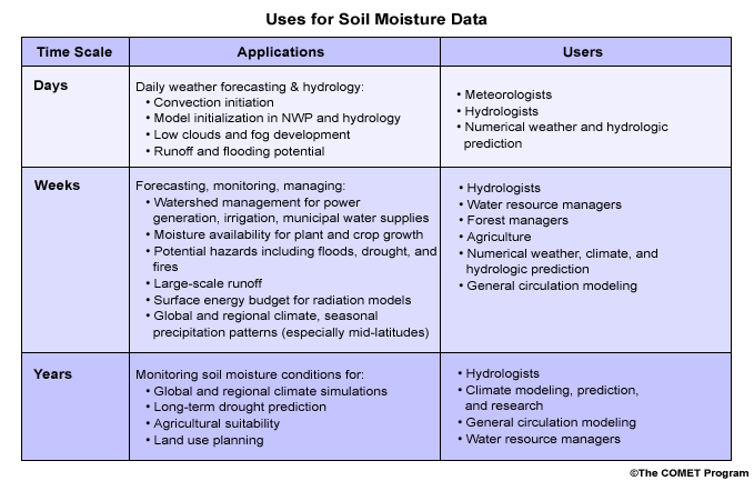
description:
Current uses and users of soil moisture data.
file name:
sm_data_uses.gif
credits:
©The COMET Program
copyright terms:
COMET Standard Terms of Use
|
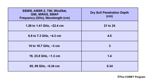
description:
Table of microwave remote sensing soil penetration depths for frequencies common to various passive microwave radiometers.
file name:
sm_pd_table.jpg
credits:
©The COMET Program
copyright terms:
COMET Standard Terms of Use
|
description:
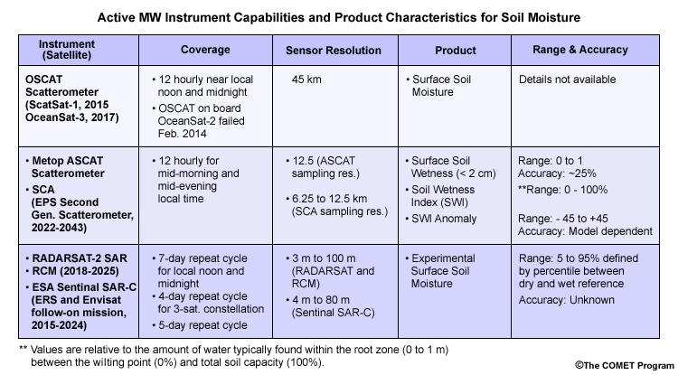
Table summarizing active microwave instrument capabilities and product characteristics for soil moisture.
file name:
sm_prod_table_active.gif
credits:
©The COMET Program
copyright terms:
COMET Standard Terms of Use
|
description:
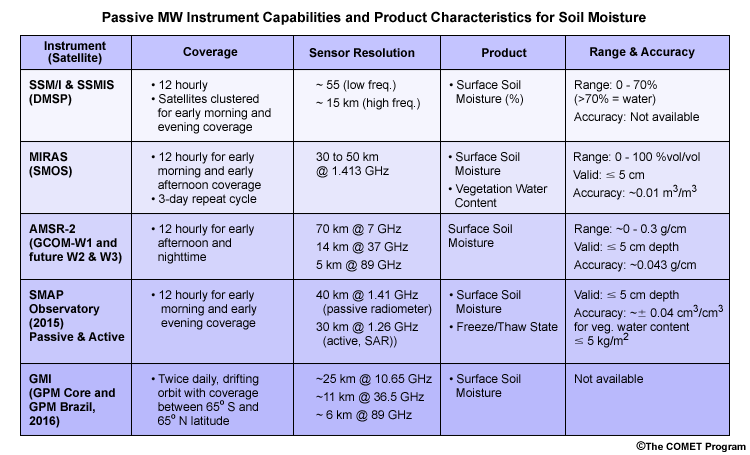
Table summarizing passive microwave instrument capabilities and product characteristics for soil moisture.
file name:
sm_prod_table_passive.gif
credits:
©The COMET Program
copyright terms:
COMET Standard Terms of Use
|
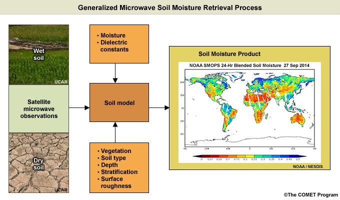
description:
Flowchart showing a generalized retrieval process for generating microwave soil moisture products.
file name:
sm_retr_process_v2.jpg
credits:
©The COMET Program (flowchart) NOAA / NESDIS (for SMOPS Blended Soil Moisture product)
copyright terms:
COMET Standard Terms of Use
|

view/save .mp4 file
description:
Animation of microwave radiation emitted from three different land surface types including, bare ground, wet ground, and wet ground with complex terrain and vegetation.
file name:
sm_vegetation.mp4
credits:
©The COMET Program
copyright terms:
COMET Standard Terms of Use
|
description:
Animation of microwave radiation emitted from three different land surface types including, bare ground, wet ground, and wet ground with complex terrain and vegetation.
file name:
sm_vegetation_scgrab1.jpg
credits:
©The COMET Program
copyright terms:
COMET Standard Terms of Use
|
description:
Animation of microwave radiation emitted from three different land surface types including, bare ground, wet ground, and wet ground with complex terrain and vegetation.
file name:
sm_vegetation_scgrab2.jpg
credits:
©The COMET Program
copyright terms:
COMET Standard Terms of Use
|
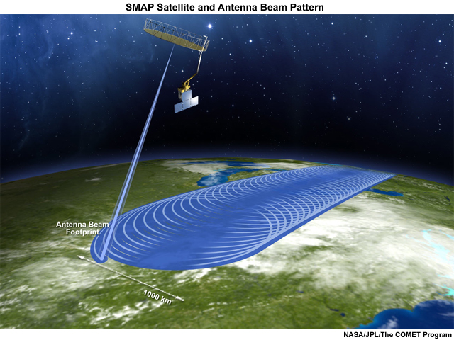
description:
SMAP (Soil Moisture Active Passive) satellite and instrument antenna beam scan pattern and swath coverage on the ground.
file name:
smap_satellite_swath.jpg
credits:
NASA/JPL/The COMET Program
copyright terms:
COMET Standard Terms of Use
|
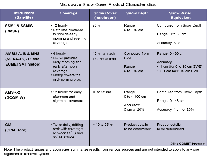
description:
Table summarizing passive microwave instrument capabilities and product characteristics for snow cover.
file name:
snow_cover_prod_table.gif
credits:
©The COMET Program
copyright terms:
COMET Standard Terms of Use
|
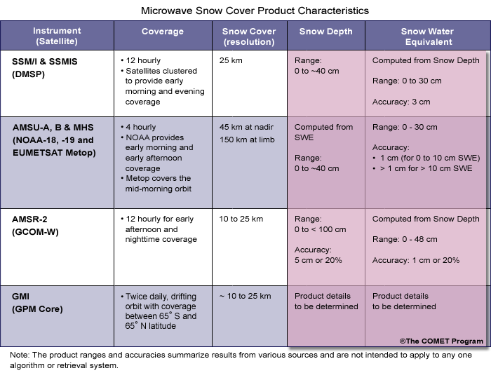
description:
Table summarizing passive microwave instrument capabilities and product characteristics for snow cover with highlights for product ranges and accuracies.
file name:
snow_cover_prod_table_v2.gif
credits:
©The COMET Program
copyright terms:
COMET Standard Terms of Use
|
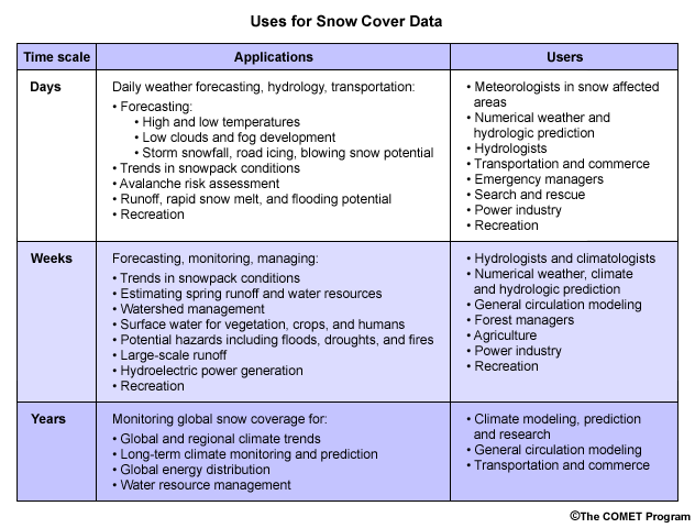
description:
Current uses and users of snow cover data.
file name:
snow_data_uses.gif
credits:
©The COMET Program
copyright terms:
COMET Standard Terms of Use
|
description:
Current uses and users of snow cover data highlighting applications on the scale of weeks.
file name:
snow_data_uses_v2.gif
credits:
©The COMET Program
copyright terms:
COMET Standard Terms of Use
|
description:
Current uses and users of snow cover data highlighting applications on the scale of years.
file name:
snow_data_uses_v3.gif
credits:
©The COMET Program
copyright terms:
COMET Standard Terms of Use
|
description:
NWS snow depth analysis over U.S. valid at 06 UTC on 22 March 2006.
file name:
snow_depth1.jpg
credits:
NOAA / NWS / NOHRSC
copyright terms:
COMET Standard Terms of Use
|
description:
NWS snow depth analysis over U.S. for 21 January 2006.
file name:
snow_depth2.jpg
credits:
NOAA / NWS / NOHRSC
copyright terms:
COMET Standard Terms of Use
|
description:
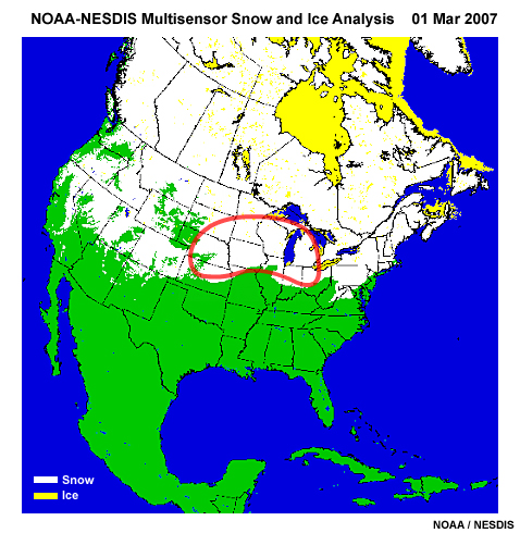
NOAA - NESDIS daily multisensor snow and ice analysis over North America with outlined region over the Upper Midwest.
file name:
snowice_chart_usa_01mar07_scgrab.jpg
credits:
NOAA / NESDIS
copyright terms:
COMET Standard Terms of Use
|
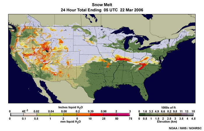
description:
NWS snow melt analysis over U.S. for 24-hour period ending 5 UTC, 22 March 2006.
file name:
snowmelt1.jpg
credits:
NOAA / NWS / NOHRSC
copyright terms:
COMET Standard Terms of Use
|
view/save .mp4 file
description:
Animation of soil emitted microwave radiation moving through a shallow vs. deep snowpack, and through a dry newer snowpack vs. wet or older snowpack.
file name:
snowpack_dd.mp4
credits:
©The COMET Program
copyright terms:
COMET Standard Terms of Use
|
view/save .mp4 file
description:
Animation of ground emitted microwave radiation contrasting the interaction between radiation and a dry new snowpack with the interaction between radiation and an aged snowpack where metamorphosis has begun to act on the snowpack.
file name:
snowpack_dry_aged.mp4
credits:
©The COMET Program
copyright terms:
COMET Standard Terms of Use
|
view/save .mp4 file
description:
Animated illustration of microwave energy passing thru dry snowpack compared to wet higher water equivalent snowpack.
file name:
snowpack_dry_wet.mp4
credits:
©The COMET Program
copyright terms:
COMET Standard Terms of Use
|
description:
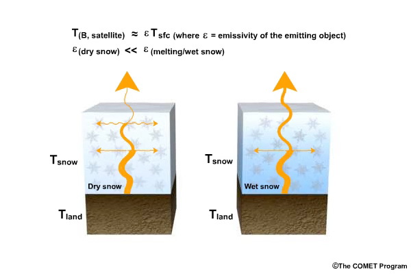
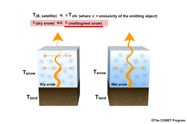
Illustration of microwave energy passing thru dry snowpack compared to wet higher water equivalent snowpack, highlighting the two emissivity terms (dry snow vs. melting/wet snow) in the second line of text.
file name:
snowpack_dry_wet_scgrab1.jpg
credits:
©The COMET Program
copyright terms:
COMET Standard Terms of Use
|
view/save .mp4 file
description:
Animation of soil emitted microwave radiation as it interacts with a fresh dry snowpack containing relatively small snowflake crystals, and an aging snowpack with relatively large snow grains.
file name:
snowpack_gs.mp4
credits:
©The COMET Program
copyright terms:
COMET Standard Terms of Use
|
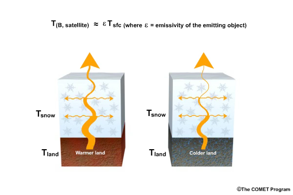
view/save .mp4 file
description:
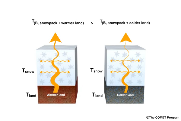
Animation of land emitted microwave radiation contrasting emission from warmer land and interaction with snowpack, with emission from colder land and interaction with snowpack.
file name:
snowpack_land_emit.mp4
credits:
©The COMET Program
copyright terms:
COMET Standard Terms of Use
|
view/save .mp4 file
description:
Animation of land emitted microwave radiation contrasting emission from warmer land and interaction with snowpack, with emission from colder land and interaction with snowpack.
file name:
snowpack_land_emit2.mp4
credits:
©The COMET Program
copyright terms:
COMET Standard Terms of Use
|
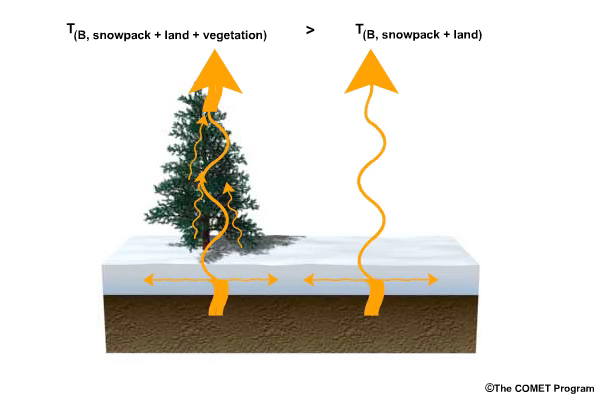
view/save .mp4 file
description:
Animation of soil emitted microwave radiation contrasting interactions with snowpack and vegetation canopy.
file name:
snowpack_limits.mp4
credits:
©The COMET Program
copyright terms:
COMET Standard Terms of Use
|
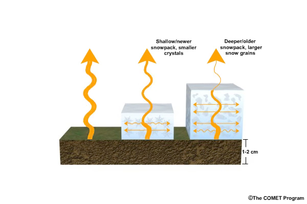
view/save .mp4 file
description:
Animation of emitted microwave radiation illustrating scattering effects of varying snowpack conditions; no snowpack, shallow/newer snowpack with smaller cystals, and deeper/older snowpack with larger snow grains.
file name:
snowpack_scattering.mp4
credits:
©The COMET Program
copyright terms:
COMET Standard Terms of Use
|
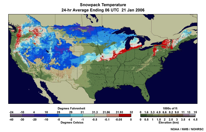
description:
NWS snowpack temperature analysis over U.S. for 24-hour period ending 6 UTC, 21 January 2006.
file name:
snowpack_temp2.jpg
credits:
NOAA / NWS / NOHRSC
copyright terms:
COMET Standard Terms of Use
|

description:
NWS snowpack temperature analysis over U.S. for 24-hour period ending 6 UTC, 22 March 2006.
file name:
snowpack_temp3.jpg
credits:
NOAA / NWS / NOHRSC
copyright terms:
COMET Standard Terms of Use
|
view/save .mp4 file
description:
Animation of snowpack emitted microwave radiation wavelength dependence. Radiation at longer microwave wavelengths are scattered less and originate from deeper within the snowpack than for shorter wavelengths.
file name:
snowpack_wl_dep.mp4
credits:
©The COMET Program
copyright terms:
COMET Standard Terms of Use
|

view loop
description:
Animation of three-hourly NOAA AVHRR infrared composite imagery from multiple orbits over the Southern Hemisphere Polar Regions from 21 UTC 11 July 2007 to 18 UTC 12 July 2007.
file name:
sp_avhrr_ir_composite_loop_0001.htm
credits:
NOAA / SSEC-AMRC
copyright terms:
COMET Standard Terms of Use
|
description:
Splash page for Microwave Remote Sensing: Land and Ocean Surface Applications, 2nd Edition lesson
file name:
splash.jpg
credits:
NOAA
copyright terms:
COMET Standard Terms of Use
|
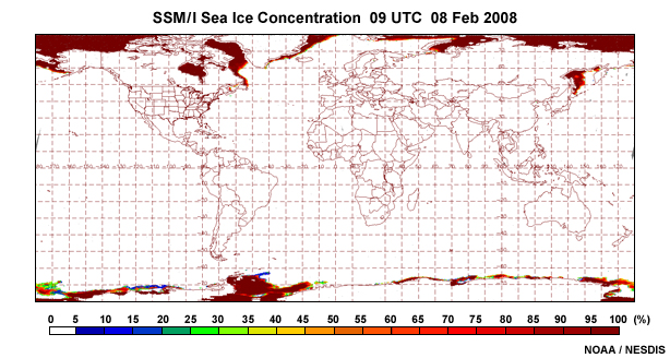
description:
SSM/I sea ice concentration product covering the Western Hemisphere on 8 February, 2008.
file name:
ssmi_ice_conc_global_08feb08.jpg
credits:
NOAA / NESDIS
copyright terms:
COMET Standard Terms of Use
|
view loop
description:
Animation of monthly snow water equivalent for the Northern Hemisphere based on visible and SSM/I passive microwave data from March 2004 to March 2005.
file name:
ssmi_swe_monthly_clim_ani_0001.htm
credits:
NSIDC
copyright terms:
COMET Standard Terms of Use
|
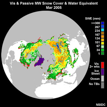
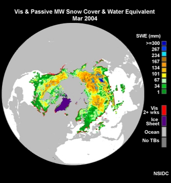
description:
Snow water equivalent for the Northern Hemisphere based on visible and SSM/I passive microwave data taken during March 2005.
file name:
ssmi_swe_monthly_clim_mar2005.jpg
credits:
NSIDC
copyright terms:
COMET Standard Terms of Use
|
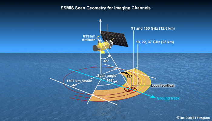
description:
Illustration of SSMIS scan geometry on board the DMSP polar-orbiting spacecraft.
file name:
ssmis_scan.jpg
credits:
©The COMET Program
copyright terms:
COMET Standard Terms of Use
|
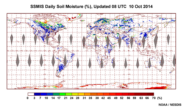
description:
Global soil moisture product from the SSMIS instrument on board the DMSP F-17 polar-orbiting satellite for 10 October, 2014.
file name:
ssmis_soil_moisture_global_10oct14.jpg
credits:
NOAA / NESDIS
copyright terms:
COMET Standard Terms of Use
|
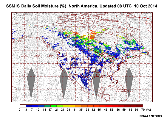
description:
Soil moisture product over North America from the SSMIS instrument on board the DMSP F-17 polar-orbiting satellite for 10 October, 2014.
file name:
ssmis_soil_moisture_nam_10oct14.jpg
credits:
NOAA / NESDIS
copyright terms:
COMET Standard Terms of Use
|
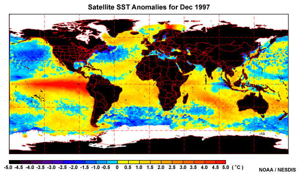
description:
Satellite derived SST anomalies for December 1997 using nighttime infrared data from AVHRR.
file name:
SST_anom_dec97.jpg
credits:
NOAA / NESDIS
copyright terms:
COMET Standard Terms of Use
|
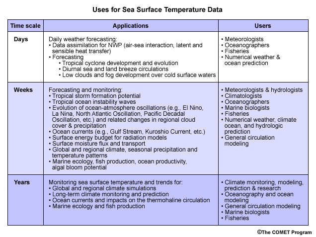
description:
Current uses and users of sea surface temperature data.
file name:
sst_data_uses.gif
credits:
©The COMET Program
copyright terms:
COMET Standard Terms of Use
|
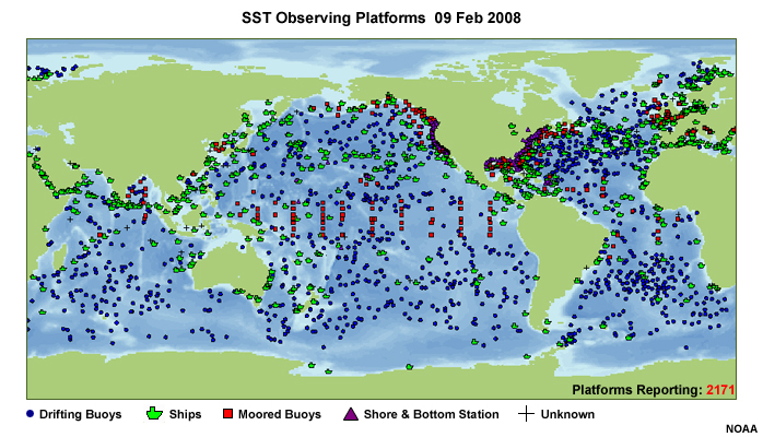
description:
Buoy and Ship Observations over a 24-hour period.
file name:
SST_platforms.jpg
credits:
NOAA
copyright terms:
COMET Standard Terms of Use
|
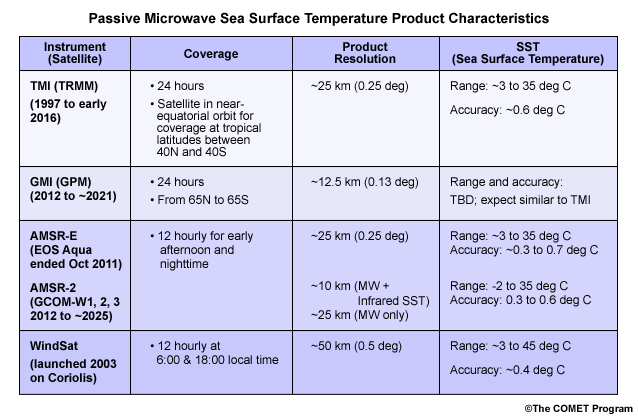
description:
A summary table of passive microwave sea surface temperature instrument capabilities and product characteristics.
file name:
sst_prod_table.gif
credits:
©The COMET Program
copyright terms:
COMET Standard Terms of Use
|
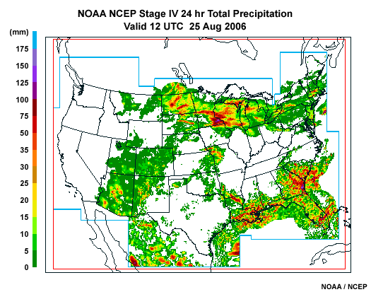
description:
NOAA NCEP Stage IV 24-hour accumulated precipitation product made from integrated radar, rain gauge, and satellite data, valid at 12 UTC on 25 August, 2006.
file name:
st4_loop_0001.gif
credits:
NOAA / NCEP
copyright terms:
COMET Standard Terms of Use
|

view loop
description:
Animation of NOAA NCEP Stage IV 24-hour accumulated precipitation product made from integrated radar, rain gauge, and satellite data, valid at 12 UTC for 25 to 28 August, 2006.
file name:
st4_loop_0001.htm
credits:
NOAA / NCEP
copyright terms:
COMET Standard Terms of Use
|
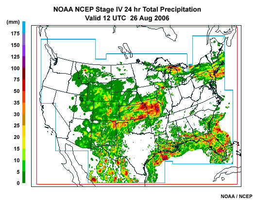
description:
NOAA NCEP Stage IV 24-hour accumulated precipitation product made from integrated radar, rain gauge, and satellite data, valid at 12 UTC on 26 August, 2006.
file name:
st4_loop_0002.gif
credits:
NOAA / NCEP
copyright terms:
COMET Standard Terms of Use
|
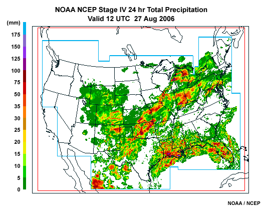
description:
NOAA NCEP Stage IV 24-hour accumulated precipitation product made from integrated radar, rain gauge, and satellite data, valid at 12 UTC on 27 August, 2006.
file name:
st4_loop_0003.gif
credits:
NOAA / NCEP
copyright terms:
COMET Standard Terms of Use
|
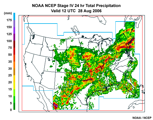
description:
NOAA NCEP Stage IV 24-hour accumulated precipitation product made from integrated radar, rain gauge, and satellite data, valid at 12 UTC on 28 August, 2006.
file name:
st4_loop_0004.gif
credits:
NOAA / NCEP
copyright terms:
COMET Standard Terms of Use
|
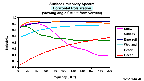
description:
Microwave emissivity spectra, horizontal polarization, for different land surface types.
file name:
surface_emissivity_spectra_Hpol.gif
credits:
NOAA / NESDIS
copyright terms:
COMET Standard Terms of Use
|
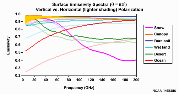
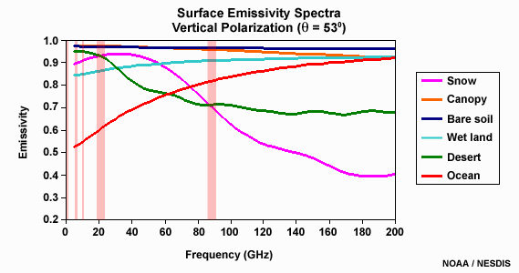
description:
Microwave emissivity spectra, vertical and horizontal polarization, for different land surface types highlighting difference between polarizations for a vegetated surface.
file name:
surface_emissivity_spectra_scgrab1.gif
credits:
NOAA / NESDIS
copyright terms:
COMET Standard Terms of Use
|
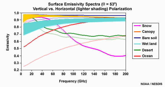
description:
Microwave emissivity spectra, vertical and horizontal polarization, for different land surface types highlighting difference between polarizations for bare wet surfaces.
file name:
surface_emissivity_spectra_scgrab2.gif
credits:
NOAA / NESDIS
copyright terms:
COMET Standard Terms of Use
|
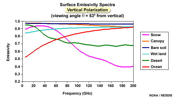
description:
Microwave emissivity spectra, vertical polarization, for different land surface types.
file name:
surface_emissivity_spectra_Vpol.gif
credits:
NOAA / NESDIS
copyright terms:
COMET Standard Terms of Use
|

description:
Microwave emissivity spectra, vertical polarization, for different land surface types highlighting lower frequencies.
file name:
surface_emissivity_spectra_vpol_scgrab1.jpg
credits:
NOAA / NESDIS
copyright terms:
COMET Standard Terms of Use
|
description:
Microwave emissivity spectra, vertical polarization, for different land surface types highlighting frequencies used for characterizing surface features.
file name:
surface_emissivity_spectra_vpol_scgrab2.jpg
credits:
NOAA / NESDIS
copyright terms:
COMET Standard Terms of Use
|
description:
Microwave emissivity spectra, vertical and horizontal polarization, for different land surface types.
file name:
surface_emissivity_spectra_wet_land.gif
credits:
NOAA / NESDIS
copyright terms:
COMET Standard Terms of Use
|
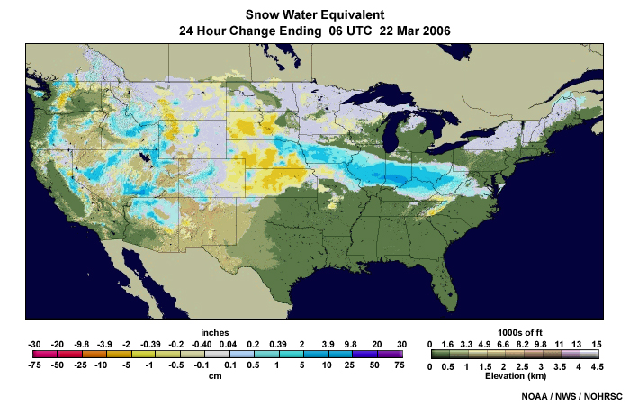
description:
NWS snow water equivalent analysis over U.S. for 22 March 2006.
file name:
swe1.jpg
credits:
NOAA / NWS / NOHRSC
copyright terms:
COMET Standard Terms of Use
|
description:
NWS snow water equivalent analysis over U.S. for 21 January 2006.
file name:
swe2.jpg
credits:
NOAA / NWS / NOHRSC
copyright terms:
COMET Standard Terms of Use
|
description:
NWS snow water equivalent, 24 hour change analysis over U.S. for 21 January 2006.
file name:
swe3.jpg
credits:
NOAA / NWS / NOHRSC
copyright terms:
COMET Standard Terms of Use
|
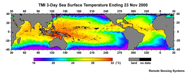
description:
TMI microwave 3-day averaged sea surface temperature for the day ending on 23 November, 2000.
file name:
tmi_3day_sst_23nov2000.jpg
credits:
Remote Sensing Systems
copyright terms:
COMET Standard Terms of Use
|
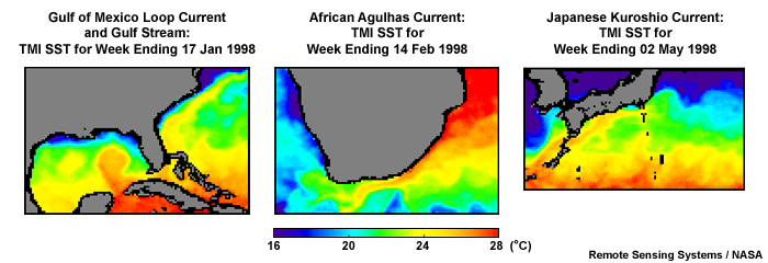
description:
Three major global warm surface currents as shown in weekly TMI SST composites including, the Gulf of Mexico Loop Current, the African Agulhas Current, and the Japanese Kuroshio Current.
file name:
tmi_global_currents_1998.jpg
credits:
Remote Sensing Systems / NASA (only one needed in lower right corner of 3-panel)
copyright terms:
COMET Standard Terms of Use
|
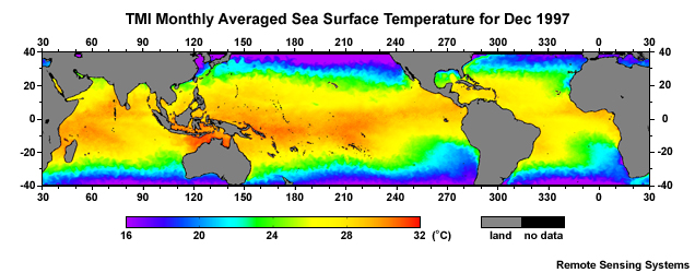
description:
TMI microwave monthly average sea surface temperature for December 1997.
file name:
tmi_monthly_sst_dec1997.jpg
credits:
Remote Sensing Systems
copyright terms:
COMET Standard Terms of Use
|
view loop
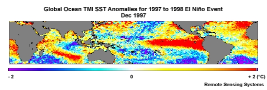
description:
Animation of global ocean TMI monthly SST anomalies for December 1997 to June 1998 during an El Nino event.
file name:
tmi_sst_anomaly_global_losninos_loop_0001.htm
credits:
Remote Sensing Systems
copyright terms:
COMET Standard Terms of Use
|
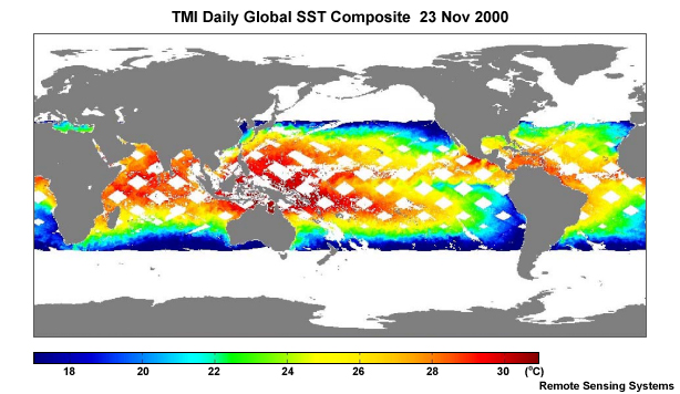
description:
TRMM Microwave Imager (TMI) daily SST composite for 23 November, 2000.
file name:
tmi_sst_daily_23nov2000.jpg
credits:
Remote Sensing Systems
copyright terms:
COMET Standard Terms of Use
|
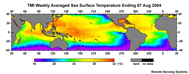
view loop
description:
Animation of TMI weekly sea surface temperatures from 07 August to 30 October, 2004.
file name:
tmi_sst_weekly_loop_0001.htm
credits:
Remote Sensing Systems
copyright terms:
COMET Standard Terms of Use
|
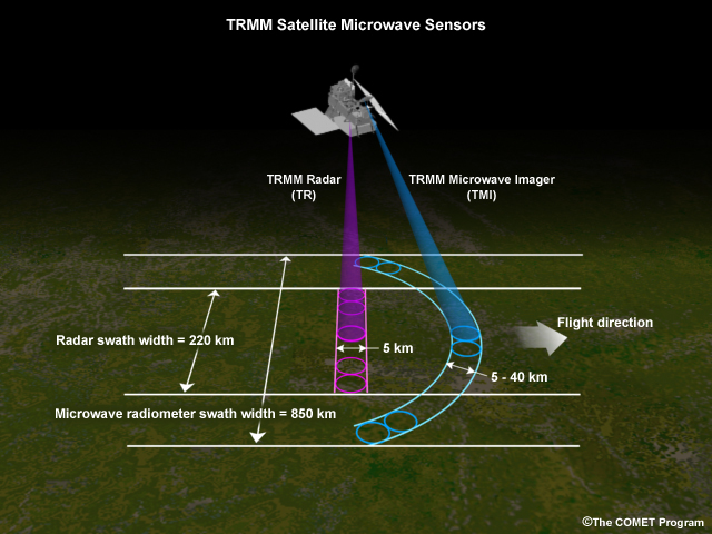
description:
Scan patterns for the TRMM Radar (TR) and TRMM (TMI) Microwave Imager instruments.
file name:
trmm_scan.jpg
credits:
©The COMET Program
copyright terms:
COMET Standard Terms of Use
|
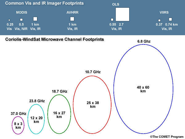
description:
Typical visible, infrared, and microwave footprints for common polar-orbiting meteorological satellites.
file name:
vis_ir_mw_footprints.jpg
credits:
©The COMET Program
copyright terms:
COMET Standard Terms of Use
|
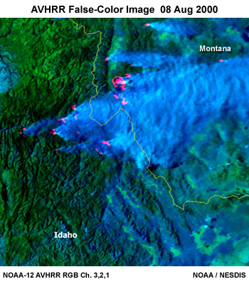
description:
Idaho and Montana fires as seen by NOAA-12 AVHRR VIS and IR RGB composite on 8 August 2000.
file name:
wildfires080800_v2.jpg
credits:
NOAA / NESDIS
copyright terms:
COMET Standard Terms of Use
|
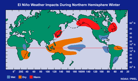
description:
Global weather impacts during the Northern Hemisphere winter due to El Niño.
file name:
winter_el_nino_impacts.gif
credits:
NOAA / PMEL
copyright terms:
COMET Standard Terms of Use
|
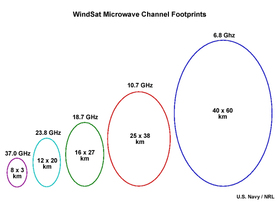
description:
Coriolis-Windsat passive microwave imager footprint shapes and sizes for each frequency channel.
file name:
ws_footprints_asc_order.jpg
credits:
U.S. Navy / NRL
copyright terms:
COMET Standard Terms of Use
|