Produced by The COMET® Program
Introduction and Case Profile
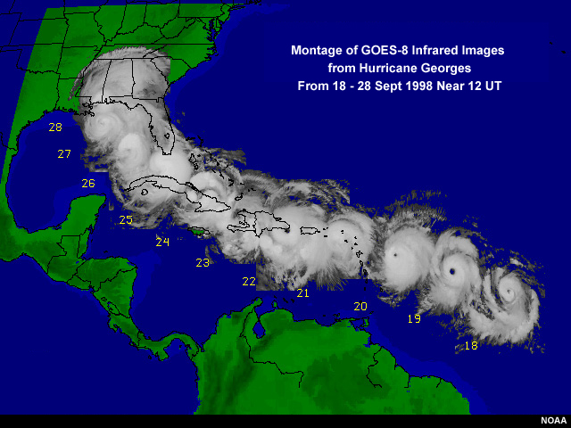
Hurricane Georges moved through the Caribbean from the 21st to the 24th of September. At 2200 UTC on September 21st, Georges made landfall on Puerto Rico and then moved on to Hispaniola where it made landfall at 1230 UTC on September 22nd. There were 600 directly related deaths in the Caribbean and billions of dollars worth of damage. Hurricane Georges began as a tropical depression off the western coast of Africa and had sustained winds of 115 mph when it made landfall in Puerto Rico. The system weakened slightly as it passed over Puerto Rico and then began intensifying over water before making landfall in the Dominican Republic on the island of Hispaniola with winds of 120 mph.
Geography
Puerto Rico and Hispaniola are located in the Greater Antilles, which also include the islands of Cuba and Jamaica. Hispaniola is divided into the countries of Haiti to the west and the Dominican Republic to the east.
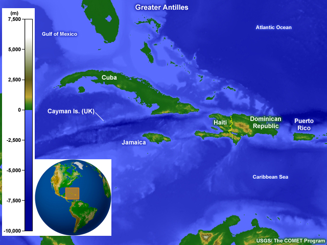
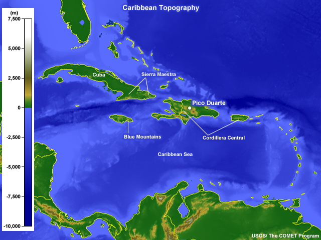
These islands are characterized by rugged terrain. Pico Duarte, in the Dominican Republic, is 3,175 m (10,417 ft) high and is a part of the Cordillera Central range of Hispaniola. In Puerto Rico, the highest peak (also in a range called the Cordillera Central) is 1,338 m (4,389 ft).
Question
Could the terrain on Puerto Rico and Hispaniola affect a hurricane as it moves over
the islands?
(Choose the best answer)
The correct answer is c).
As we will see as we move through this case study, the terrain in both Puerto Rico and Hispaniola affects Hurricane Georges and the resulting precipitation from the system.
Climatology
Hurricane season in the tropical Atlantic Ocean and Caribbean Sea runs from June 1st to November 30th each year. There are preferred times during the season when tropical cyclones develop in the and near the Caribbean Sea.
Question 1 of 2
How would you describe mid-September in terms of the development of tropical
cyclones?
(Choose the best answer)
The correct answer is b).
ITropical cyclogenesis in the Caribbean actually reaches a maximum during September when we tend to see the warmest sea surface temperatures of the season and relatively weak wind shear.
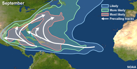
The prevailing tracks that tropical cyclones take in September in the Atlantic and Caribbean are plotted below.
Question 2 of 2
What is the most likely track a tropical cyclone takes through the eastern Caribbean
in September?
(Choose the best answer)
The correct answer is a).
You can see that the tracks in the Caribbean show primarily westward movement that curves toward the north and then northeastward as they approach North America. Keep in mind that these are average conditions based on historical data. Tropical cyclones can and do travel along much different paths depending on the specific conditions affecting that system.
Learn more about the climatology of the tropical cyclones in this region in the lesson Forecasters' Overview of the Gulf of Mexico and Caribbean Sea.
Conceptual Model of Tropical Cyclones
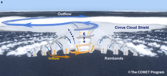
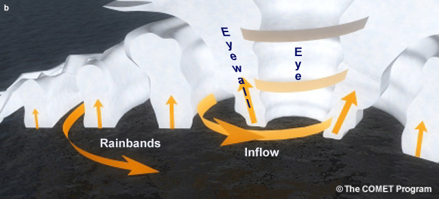
A tropical cyclone has distinct features that are associated with the formation of the system. Winds flow inward cyclonically at lower levels and spiral upward. At the top of the storm, winds spiral outward. This flow leads to the development of a clear region in the center of the system known as the eye. Within the eye, conditions are relatively calm with light winds. This is also the location of the lowest surface pressure. Surrounding the eye is a band of thunderstorms within the strongest winds. This band is called the eyewall. Extending out from the eyewall are rainbands with strong convection and areas of heavy rain.
Conceptual model of a hurricane
Close-up conceptual model of a hurricane
You can learn more about tropical cyclones in the online textbook Introduction to Tropical Meteorology, 2nd Edition.
Case Challenge
Outline
- Relate radar signatures to structural characteristics of a tropical cyclone.
- Identify the impact of terrain on convection within the hurricane using radar data.
- Describe potential impacts of hurricane force winds on structures.
- Correlate resulting precipitation to the influence of the hurricane track and terrain.
Landfall
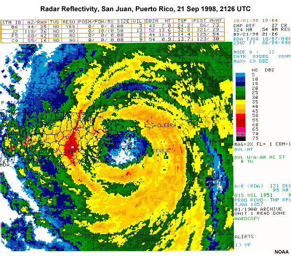
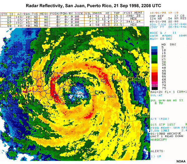
Hurricane Georges made landfall over Puerto Rico during the early evening of September 21st. Maximum sustained winds were 115 mph. Examine the following radar images to evaluate the changes Georges underwent as it moved over the island.
21 Sep, 2126 UTC
21 Sep, 2208 UTC
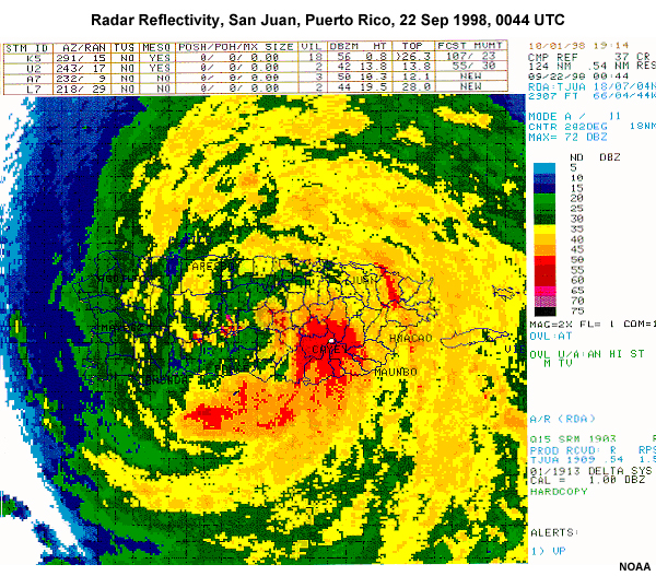
22 Sep, 0044 UTC
Question 1 of 2
What can you say about the eye of Hurricane Georges as it moved over Puerto Rico?
(Choose the best answer)
The correct answer is b).
As Georges moves over Puerto Rico, the definition of the eye of the hurricane decreases and by 0044 UTC on the 22nd, it is difficult to discern.
Question 2 of 2
How does the the symmetry seen in the rainbands surrounding Hurricane Georges change
between 2208 UTC on September 21st and 0044 UTC on September 22nd?
(Choose the
best answer)
The correct answer is d).
At 2208 UTC on September 21st, the hurricane looks relatively symmetric with high reflectivities somewhat evenly distributed in the rainbands around the eye. Later, at 0044 UTC on the 22nd, the eye has lost its definition and convection has become more pronounced in the southeast quadrant.
Crossing Puerto Rico
This animation of radar reflectivity data shows the entire trip of Hurricane Georges across Puerto Rico.
Question
What happens to the hurricane as it moves back over water near the end of the loop?
(Choose the
best answer)
The correct answer is a).
A. As the storm moves over Puerto Rico, it loses some of its organization. But it begins to regain as it moves over the water again and the eye reforms.
Hispaniola
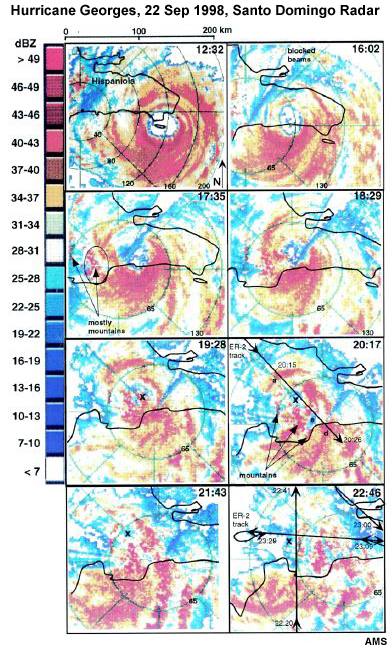
Hurricane Georges left Puerto Rico and next made landfall on Hispaniola at 1230 UTC on September 22nd. The system weakened significantly as it moved across the island and the eye, which had become visible prior to landfall, disappeared. The radar panels shown below are from the Santo Domingo radar.
Topography
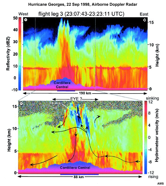
During this storm, airborne observations of the storm were taken with Doppler radar. We will review some of these data to examine the role that topography played in convective development within the storm. This cross section was taken slightly to the north of the main circulation with the terrain plotted along the bottom. The top image shows the reflectivity legend on the left and height plotted along the right. The lower image shows the height plotted along the left side and the vertical velocity legend along the right.
Question
What indications are present in the imagery that suggest the topography of the island
affected convective development within Hurricane Georges?
(Choose the best
answer)
The correct answer is c).
Both the reflectivity field and the vertical velocity field show significantly higher values over the higher topography region. The mountainous terrain played an important role in enhancing convection already associated with the hurricane.
Assessing Impacts
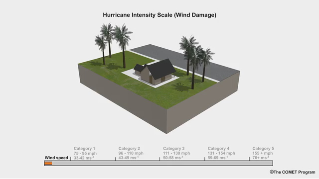
View the animation showing wind damage associated with hurricanes and answer the question related to winds observed with Hurricane Georges.
Question 1 of 2
On the east coast of Puerto Rico, there was a recorded wind speed of 110 mph
sustained and gusts of up to 130 mph. What kind of damages would we expect to see
with this kind of wind speed?
(Choose the best
answer)
The correct answer is d).
Winds from 100 mph to 130 mph can be expected to cause major damage to homes.
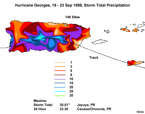
Hurricane Georges devastated many parts of Puerto Rico with major flooding and mudslides due to heavy rainfall. Widespread massive rainfall in excess of 20 inches fell over Puerto Rico with localized regions of higher amounts. The rain that fell in the mountains flowed down into the rivers, causing major floods and mudslides. The raging flood waters washed out over 2100 bridges and mudslides affected over 7000 kilometers of roadways in Puerto Rico. Overall, 12 deaths in Puerto Rico were attributed to the storm. The total damages from Hurricane Georges in Puerto Rico were estimated to be above 2 billion dollars.
Question 2 of 2
Why was the location of heaviest rain over the mountains?
(Choose the best
answer)
The correct answer is a).
The track of the storm followed the mountain range that runs through the center of the island. The complex terrain created additional lift to result in enhanced precipitation.
The damage continued as the storm moved over Hispaniola with over 300 dead in Haiti and the Dominican Republic and losses estimated at over $1 billion. In the Dominican Republic estimates included that 100,000 people were homeless and 70% of the bridges in the region were damaged. Agriculture in the region took a tremendous hit as most of the crops were destroyed.
Summary
Hurricane Georges had a devastating effect along its track. This storm provides the opportunity to evaluate the role that complex terrain played in the enhancement of precipitation associated with the storm.
Radar imagery is an important dataset to include in determining the strength of a hurricane and the intensity of the rainfall associated with it. Doppler radar provides details of the reflectivity and velocity patterns associated with the storm.
We found that topography on the Caribbean islands of Puerto Rico and Hispaniola affected the resulting rainfall amounts associated with the storm. The coincidence of the storm track along the mountain ranges on both islands gave a unique situation that allowed us to focus specifically on the effects of terrain. Higher values were seen in the reflectivity of the rainbands over complex terrain and in the storm total rainfall amounts indicating that the increased lift provided by the terrain enhanced the convection already occurring with the storm.
References
- Bennet, S. P. and R. Mojica, National Weather Service Forecast Office, San Juan, Puerto
Rico, Hurricane Georges Preliminary Storm Report. From the Tropical Atlantic to the United
States Virgin Islands and Puerto Rico.
http://www.srh.noaa.gov/sju/?n=1998_georges - Geerts, B., G. M. Heymsfield, L. Tian, J. B. Halverson, A. Guillory, and M. I. Mejia, 2000: Hurricane Georges’s Landfall in the Dominican Republic: Detailed Airborne Doppler Radar Imagery. Bull. Amer. Meteor. Soc., 81 , 999–1018.
- Forecasters’ Overview of the Gulf of Mexico and Caribbean Sea
- Hydrometeorological Prediction Center’s analysis of precipitation associated with Hurricane
Georges
http://www.hpc.ncep.noaa.gov/tropical/rain/georges1998.html - Introduction to Tropical Meteorology 2nd Edition, Chapter 8
- National Climatic Data Center: Georges Pummels Caribbean, Florida Keys, and U.S. Gulf Coast
http://www.ncdc.noaa.gov/oa/reports/georges/georges.html - National Hurricane Center, Preliminary Report on Hurricane Georges, 15 September - 01 October 1998 by John L. Guiney: https://www.nhc.noaa.gov/data/tcr/AL071998_Georges.pdf