Media elements used in this module are protected by a variety of copyright licenses. Please use the "copyright terms" link associated with each item below for more information.
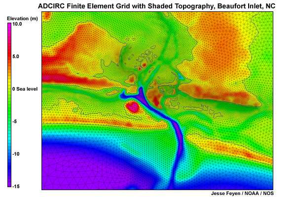
Description:
ADCIRC Finite Element Grid for Beaufort Inlet, NC
File Name:
beaufort_grid.jpg
Credits:
Jesse Feyen / NOAA / NOS
Copyright Terms:
COMET Standard Terms of Use
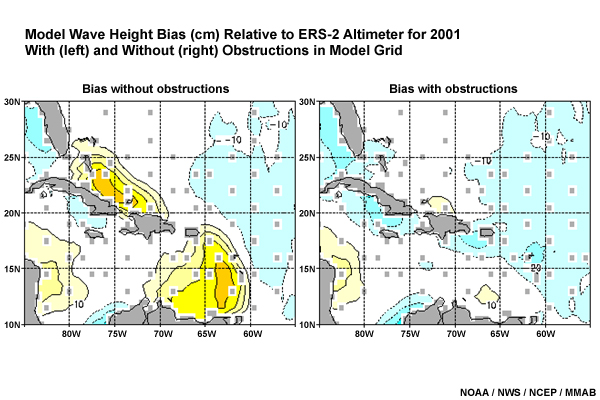
Description:
Model Wave Height Bias Relative to ERS-2 Altimeter for 2001
With (left) and Without (right) Obstructions in Model Grid
File Name:
carib_obstruct_bias.jpg
Credits:
NOAA / NWS / NCEP MMAB
Copyright Terms:
COMET Standard Terms of Use
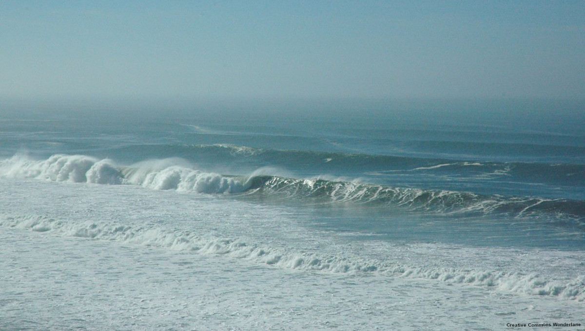
Description:
Waves crashing on beach
File Name:
cc_crashingwaves.jpg
Credits:
Creative Commons Wonderlane
Copyright Terms:
Attribution-NonCommercial-NoDerivs 2.0 Generic
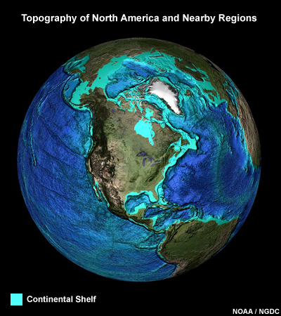
Description:
Picture of globe with topography/bathymetry
File Name:
continental_shelf.jpg
Credits:
NOAA / NGDC
Copyright Terms:
COMET Standard Terms of Use
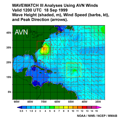
Description:
Wavewatch III Analysis Using AVN Winds valid 1200 UTC 18 Sep 1999 showing Hurricanes Floyd and Gert.
Wave Height (shaded, m), Wind Speed (barbs, kt), and Peak Direction (arrows).
File Name:
floyd_gert_avn.jpg
Credits:
NOAA / NWS / NCEP MMAB
Copyright Terms:
COMET Standard Terms of Use
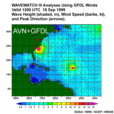
Description:
Wavewatch III Analysis Using GDFL Winds valid 1200 UTC 18 Sep 1999 showing Hurricanes Floyd and Gert.
Wave Height (shaded, m), Wind Speed (barbs, kt), and Peak Direction (arrows).
File Name:
floyd_gert_gdfl.jpg
Credits:
NOAA / NWS / NCEP MMAB
Copyright Terms:
COMET Standard Terms of Use
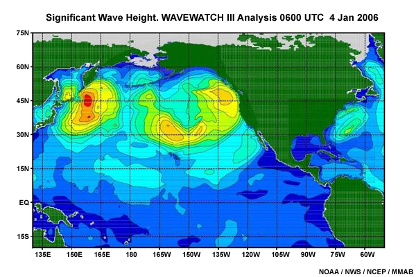
Description:
Significant Wave Height. Wavewatch III Analysis 0600 UTC 4 Jan 2006
File Name:
global_ww3_hs_4jan06_01.jpg
Credits:
NOAA / NWS / NCEP MMAB
Copyright Terms:
COMET Standard Terms of Use
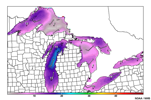
Description:
Graphic forecast of wind
File Name:
great_lakes_wind.jpg
Credits:
NOAA / NWS
Copyright Terms:
COMET Standard Terms of Use
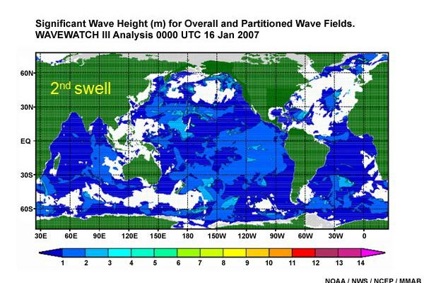
Description:
Significant Wave Height (m) for Overall and Partitioned Wave Fields.
Wavewatch III Analysis 0000 UTC 16 Jan 2007
File Name:
hs_wave_fields_16jan07_0001.htm
Credits:
NOAA / NWS / NCEP MMAB
Copyright Terms:
COMET Standard Terms of Use
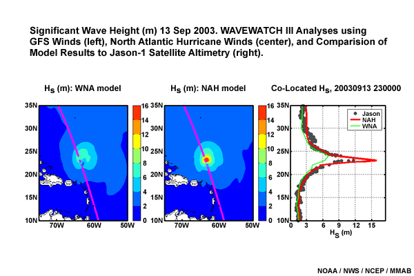
Description:
Significant Wave Height (m) 13 Sep 2003. Wavewatch III Analyses using GFS Winds (left), North Atlantic Hurricane Winds (center), and Comparison of Model Results to Jason-1 Satellite Altimetry (right).
File Name:
isabel_13sep03.jpg
Credits:
NOAA / NWS / NCEP MMAB
Copyright Terms:
COMET Standard Terms of Use
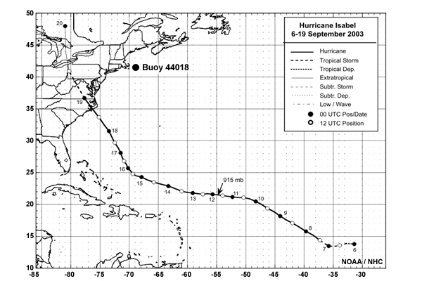
Description:
Track of hurricane Isabel and location of Buoy 44018
File Name:
isabel_buoy_location.jpg
Credits:
NOAA / NHC
Copyright Terms:
COMET Standard Terms of Use
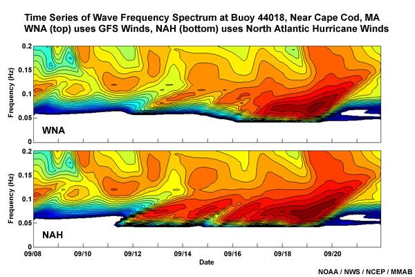
Description:
Time Series of Wave Frequency Spectrum at Buoy 44018, near Cape Cod, MA,
WNA (top) uses GFS Winds, NAH (bottom) uses North Atlantic Hurricane Winds
File Name:
isabel_timeseries.jpg
Credits:
NOAA / NWS / NCEP MMAB
Copyright Terms:
COMET Standard Terms of Use
Description:
Time Series of Wave Frequency Spectrum at Buoy 44018, near Cape Cod, MA,
WNA (top) uses GFS Winds, NAH (bottom) uses North Atlantic Hurricane Winds
File Name:
isabel_timeseries.jpg
Credits:
NOAA / NWS / NCEP MMAB
Copyright Terms:
COMET Standard Terms of Use
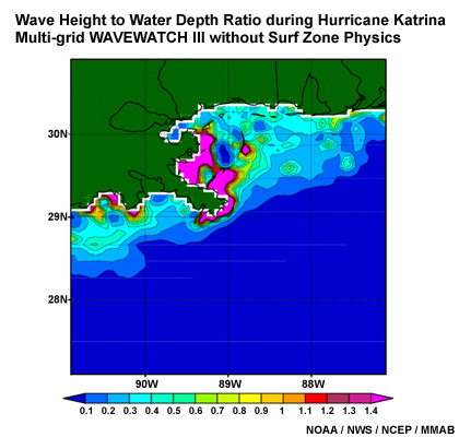
Description:
Wave Height to Water Depth Ratio during Hurricane Katrina
Multi-grid Wavewatch III without Surf Zone Physics
File Name:
katrina_hs_ratio1.jpg
Credits:
NOAA / NWS / NCEP MMAB
Copyright Terms:
COMET Standard Terms of Use
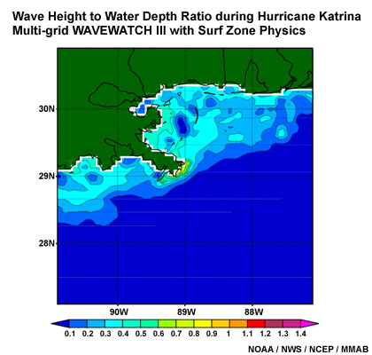
Description:
Wave Height to Water Depth Ratio during Hurricane Katrina
Multi-grid Wavewatch III with Surf Zone Physics
File Name:
katrina_hs_ratio2.jpg
Credits:
NOAA / NWS / NCEP MMAB
Copyright Terms:
COMET Standard Terms of Use

Description:
Significant Wave Height (m) during Hurricane Katrina
Wavewatch III with 1/8 degree Grid
File Name:
katrina_hs1.jpg
Credits:
NOAA / NWS / NCEP MMAB
Copyright Terms:
COMET Standard Terms of Use
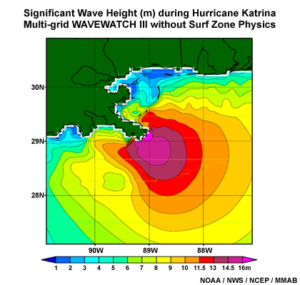
Description:
Significant Wave Height (m) during Hurricane Katrina
Multi-grid Wavewatch III without Surf Zone Physics
File Name:
katrina_hs2.jpg
Credits:
NOAA / NWS / NCEP MMAB
Copyright Terms:
COMET Standard Terms of Use
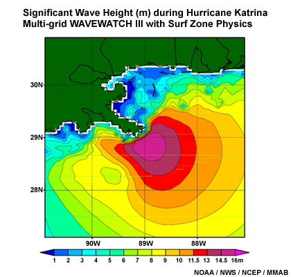
Description:
Significant Wave Height (m) during Hurricane Katrina
Multi-grid Wavewatch III with Surf Zone Physics
File Name:
katrina_hs3.jpg
Credits:
NOAA / NWS / NCEP MMAB
Copyright Terms:
COMET Standard Terms of Use
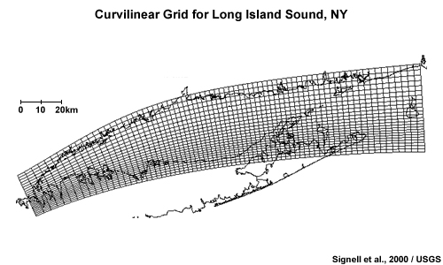
Description:
Curvilinear Grid for Long Island Sound, NY
File Name:
long_island_grid.jpg
Credits:
Signell et al., 2000 / USGS
Copyright Terms:
COMET Standard Terms of Use
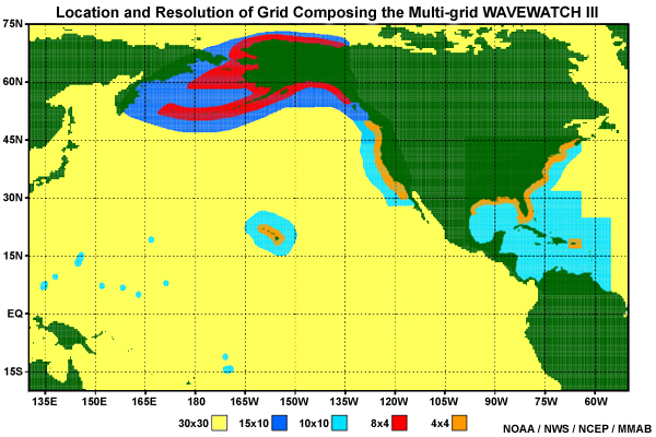
Description:
Location and Resolution of Grids Composing the Multi-grid Wavewatch III
File Name:
multigrid_location.jpg
Credits:
NOAA / NWS / NCEP MMAB
Copyright Terms:
COMET Standard Terms of Use
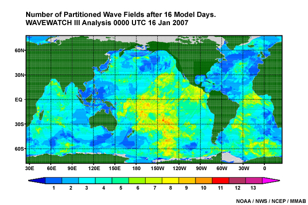
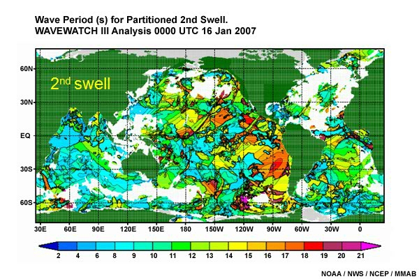
Description:
Number of Partitioned Wave Fields. Wavewatch III Analysis 0000 UTC 16 Jan 2007
File Name:
partition_wave_fields_16jan07.jpg
Credits:
NOAA / NWS / NCEP MMAB
Copyright Terms:
COMET Standard Terms of Use
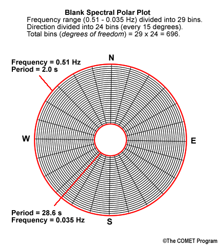
Description:
Blank polar grid
File Name:
polar_grid.png
Credits:
©The COMET Program
Copyright Terms:
COMET Standard Terms of Use
Description:
Peak Wave Period (s) for Overall and Partitioned Wave Fields.
Wavewatch III Analysis 0000 UTC 16 Jan 2007
File Name:
pp_wave_fields_16jan07_0001.htm
Credits:
NOAA / NWS / NCEP MMAB
Copyright Terms:
COMET Standard Terms of Use

Description:
Rayleigh distribution of wave heights
File Name:
rayleigh_distribution.jpg
Credits:
NOAA
Copyright Terms:
COMET Standard Terms of Use
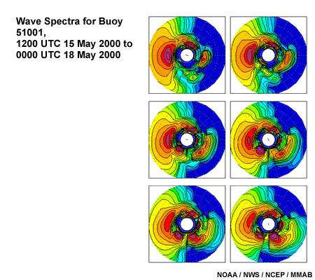
Description:
Wave Spectra for Buoy 51001, 1200 UTC 15 May 2000 to 0000 UTC 18 May 2000
File Name:
spectra_51001.jpg
Credits:
NOAA / NWS / NCEP MMAB
Copyright Terms:
COMET Standard Terms of Use
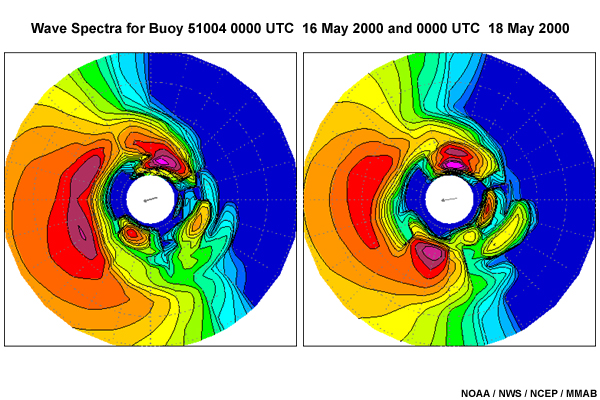
Description:
Wave Spectra for Buoy 51004 00 UTC 16 May 2000 and 00 UTC 18 May 2000
File Name:
spectra_51004.jpg
Credits:
NOAA / NWS / NCEP MMAB
Copyright Terms:
COMET Standard Terms of Use
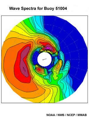
Description:
WAVEWATCH III Wave spectrum at buoy 51004 16 May 2000
File Name:
spectra_51004_16may2000.jpg
Credits:
NOAA/NWS/NCEP/MMAB
Copyright Terms:
COMET Standard Terms of Use
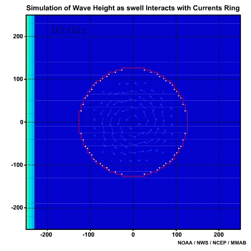
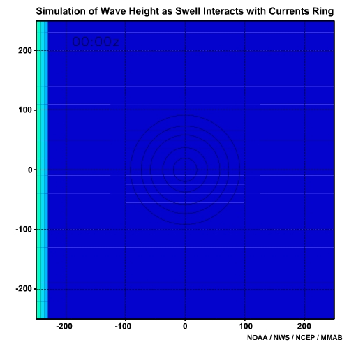
Description:
Simulation of Wave Height as Swell Interacts with Current Ring
File Name:
swell_ring_0001.htm
Credits:
NOAA / NWS / NCEP / MMAB
Copyright Terms:
COMET Standard Terms of Use
Description:
Simulation of Wave Height as Swell Refracts Around and Shoals Over a Seamount
File Name:
swell_seamount_0001.htm
Credits:
NOAA / NWS / NCEP / MMAB
Copyright Terms:
COMET Standard Terms of Use

Description:
Mesh diagram of wave partitioning on a plot of energy density versus frequency and direction
File Name:
wave_partition_51028.jpg
Credits:
Tracy et al. 2007/USACE
Copyright Terms:
COMET Standard Terms of Use

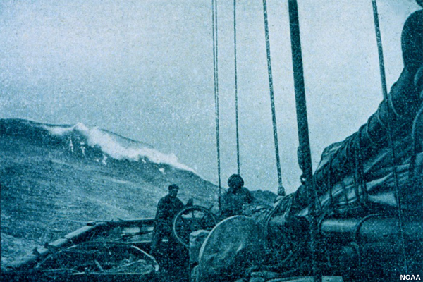
Description:
Photo of wave from ship
File Name:
waves_diffraction.jpg
Credits:
NOAA
Copyright Terms:
COMET Standard Terms of Use
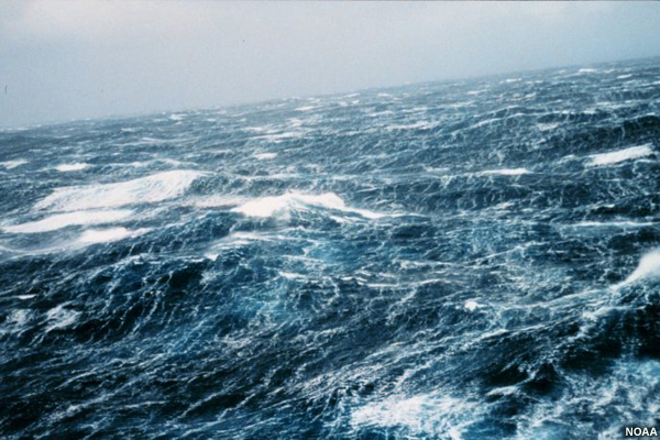
Description:
Photo of waves
File Name:
waves1.jpg
Credits:
NOAA
Copyright Terms:
COMET Standard Terms of Use

Description:
Photo of waves
File Name:
waves2.jpg
Credits:
U.S. Navy / ONR
Copyright Terms:
COMET Standard Terms of Use
Description:
Photo of wave from ship
File Name:
waves3.jpg
Credits:
NOAA
Copyright Terms:
COMET Standard Terms of Use
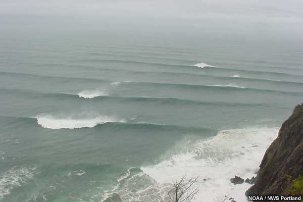
Description:
photo of surf
File Name:
waves4.jpg
Credits:
NOAA / NWS Portland
Copyright Terms:
COMET Standard Terms of Use
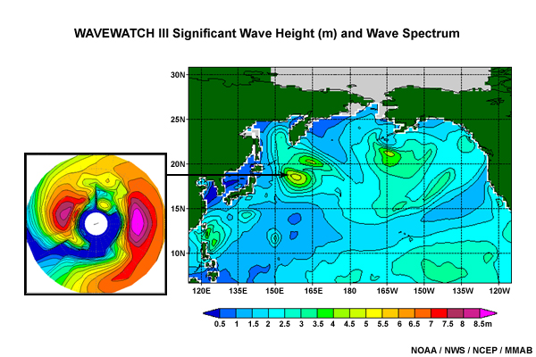
Description:
Example of significant wave height for the North Pacific with an wave spectrum plot for a location near Japan
File Name:
wpac_hs_spectrum.jpg
Credits:
NOAA / NWS / NCEP / MMAB
Copyright Terms:
COMET Standard Terms of Use
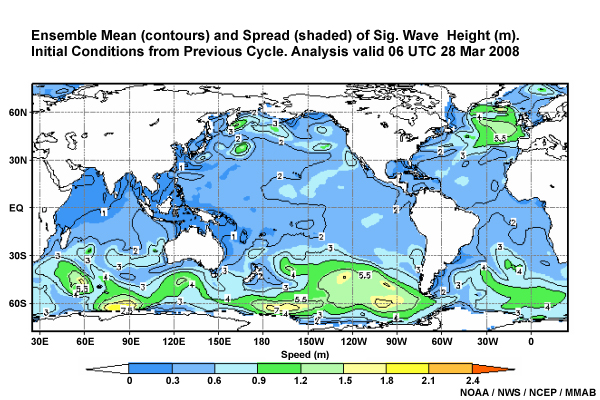
Description:
Ensemble Mean (contours) and Spread (shaded) of Sig. Wave Height (m).
Initial Conditions from Previous Cycle. Analysis valid 06 UTC 28 Mar 2008
File Name:
ww3_0h_ensemble_cycle.jpg
Credits:
NOAA / NWS / NCEP MMAB
Copyright Terms:
COMET Standard Terms of Use
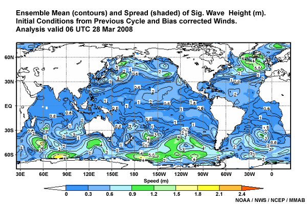
Description:
Ensemble Mean (contours) and Spread (shaded) of Sig. Wave Height (m).
Initial Conditions from Previous Cycle and Bias corrected Winds.
Analysis valid 06 UTC 28 Mar 2008
File Name:
ww3_0h_ensemble_cyclebc.jpg
Credits:
NOAA / NWS / NCEP MMAB
Copyright Terms:
COMET Standard Terms of Use
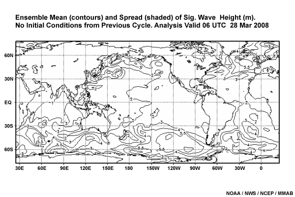
Description:
Ensemble Mean (contours) and Spread (shaded) of Sig. Wave Height (m).
No Initial Conditions from Previous Cycle. Analysis valid 06 UTC 28 Mar 2008
File Name:
ww3_0h_ensemble_old.jpg
Credits:
NOAA / NWS / NCEP MMAB
Copyright Terms:
COMET Standard Terms of Use

Description:
Ensemble Mean (contours) and Spread (shaded) of Sig. Wave Height (m).
Initial Conditions from Previous Cycle. 120 hour Forecast valid 06 UTC 02 Apr 2008
File Name:
ww3_120h_ensemble_cycle.jpg
Credits:
NOAA / NWS / NCEP MMAB
Copyright Terms:
COMET Standard Terms of Use

Description:
Ensemble Mean (contours) and Spread (shaded) of Sig. Wave Height (m).
Initial Conditions from Previous Cycle and Bias corrected Winds.
120 hour Forecast valid 06 UTC 02 Apr 2008
File Name:
ww3_120h_ensemble_cyclebc.jpg
Credits:
NOAA / NWS / NCEP MMAB
Copyright Terms:
COMET Standard Terms of Use
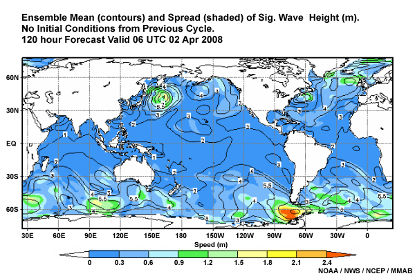
Description:
Ensemble Mean (contours) and Spread (shaded) of Sig. Wave Height (m).
No Initial Conditions from Previous Cycle. 120 hour Forecast valid 06 UTC 02 Apr 2008
File Name:
ww3_120h_ensemble_old.jpg
Credits:
NOAA / NWS / NCEP MMAB
Copyright Terms:
COMET Standard Terms of Use
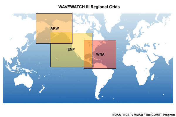
Description:
WAVEWATCH III Regional Grids
File Name:
ww3_regional_grids.jpg
Credits:
NOAA / NCEP / MMAB / The COMET Program
Copyright Terms:
COMET Standard Terms of Use