Media elements used in this module are protected by a variety of copyright licenses. Please use the "copyright terms" link associated with each item below for more information.
Description:
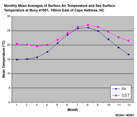
Monthly Mean Averages of Surface Air Temperature and Sea Surface Temperature at Buoy 41001, 150 nm East of Cape Hatteras, NC
File Name:
airT_vs_SST.gif
Credits:
NOAA / NDBC
Copyright Terms:
COMET Standard Terms
of Use
Description:
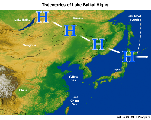
Map of East Asia with trajectories of NE, E, and W Baikal Highs during cold air outbreaks
File Name:
baikal_high_1.jpg
Credits:
©The COMET Program
Copyright Terms:
COMET Standard Terms
of Use
Description:
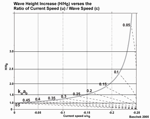
Graph of wave growth versus current speed
File Name:
baschek_fig5_ex1.gif
Credits:
Baschek 2005
Copyright Terms:
COMET Standard Terms
of Use
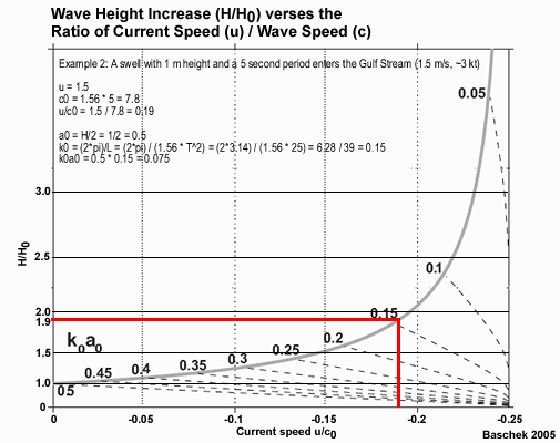
Description:
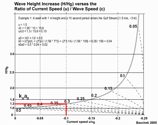
Graph of wave growth versus current speed with example of application
File Name:
baschek_fig5_ex2.gif
Credits:
Baschek 2005
Copyright Terms:
COMET Standard Terms
of Use
Description:
Graph of wave growth versus current speed with example of application
File Name:
baschek_fig5_ex3.gif
Credits:
Baschek 2005
Copyright Terms:
COMET Standard Terms
of Use
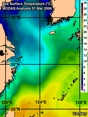
Description:
Map of Sea Surface Temperature ( C) near East China Sea. COAMPS Analysis 28 Feb 2006
File Name:
ecs_sst_coamps_1mar06.gif
Credits:
U.S. Navy
Copyright Terms:
COMET Standard Terms
of Use
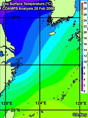
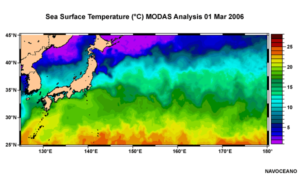
Description:
Map of Sea Surface Temperature ( C) near East China Sea. MODAS Analysis 1 Mar 2006
File Name:
ecs_sst_modas_1mar06.gif
Credits:
U.S. Navy
Copyright Terms:
COMET Standard Terms
of Use
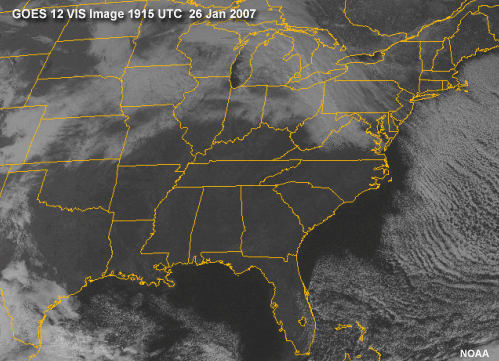
Description:
GOES 12 VIS Image of the Eastern U.S. 1915 UTC 26 Jan 2007
File Name:
g12vis26jan07.gif
Credits:
NOAA
Copyright Terms:
COMET Standard Terms
of Use
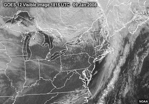
Description:
GOES 12 Visible Image 1815 UTC 9 Jan 2008
File Name:
g12vis9jan08.jpg
Credits:
NOAA
Copyright Terms:
COMET Standard Terms
of Use
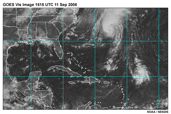
Description:
GOES VIS Image 1515 UTC 11 Sep 2006
File Name:
goes_vis_watl_15z11sep06.gif
Credits:
NOAA / NESDIS
Copyright Terms:
COMET Standard Terms
of Use
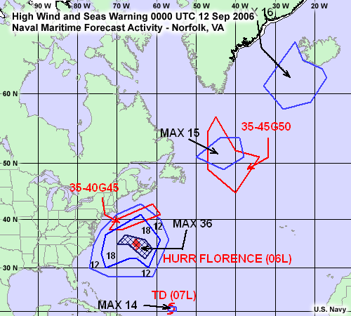
Description:
High Wind and Seas Warning 00 UTC 12 Sep 2006, Naval Maritime Forecast Activity - Norfolk, VA
File Name:
hi_wind_seas_00z12sep06.gif
Credits:
U.S. Navy
Copyright Terms:
COMET Standard Terms
of Use
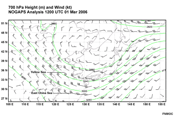
Description:
700 hPa Height (m) and Wind (kt) NOGAPS Analysis 12 UTC 1 Mar 2006, East Asia
File Name:
ht700_wind_12z1mar06.gif
Credits:
FNMOC
Copyright Terms:
COMET Standard Terms
of Use
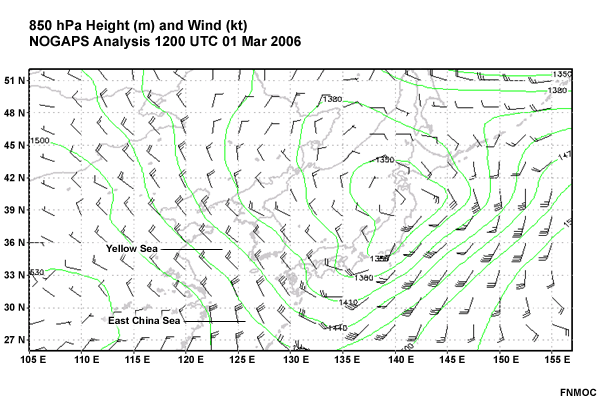
Description:
850 hPa Height (m) and Wind (kt) NOGAPS Analysis 12 UTC 1 Mar 2006, East Asia
File Name:
ht850_wind_12z1mar06.gif
Credits:
FNMOC
Copyright Terms:
COMET Standard Terms
of Use
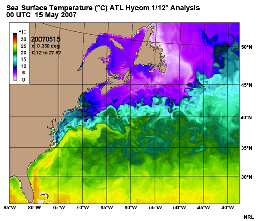
Description:
Sea Surface Temperature ( C) in the NW Atlantic.
ATL Hycom 1/12 Analysis 00 UTC 15 May 2007
File Name:
hycom_sst.jpg
Credits:
NRL
Copyright Terms:
COMET Standard Terms
of Use
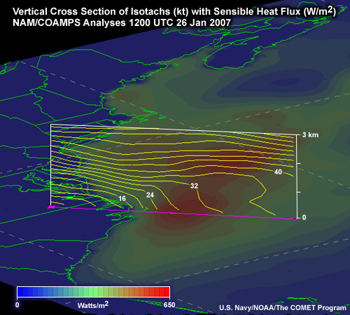
Description:
Vertical Cross Section of Isotachs (kt) with Sensible Heat Flux (W/m )
NAM/COAMPS Analyses 1200 UTC 26 Jan 2007
File Name:
isotachs_3d_12z26Jan07.jpg
Credits:
U.S. Navy / NOAA / The COMET Program
Copyright Terms:
COMET Standard Terms
of Use
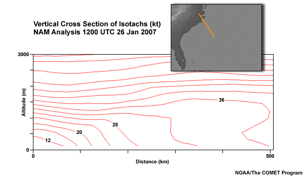
Description:
Vertical Cross Section of Isotachs (kt)
NAM Analysis 1200 UTC 26 Jan 2007
File Name:
isotachs_xsect_12z26jan07.jpg
Credits:
NOAA / The COMET Program
Copyright Terms:
COMET Standard Terms
of Use
Description:
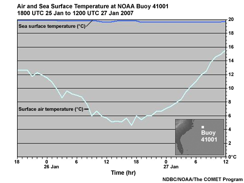
Time series of air and sea surface temperatures during a North Wall Event.
File Name:
jan_gs_timeseries1.jpg
Credits:
NDBC / NOAA / The COMET Program
Copyright Terms:
COMET Standard Terms
of Use
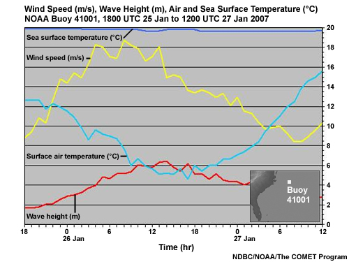
Description:
Time series of wind speed, wave height, and air and sea surface temperatures during a North Wall Event.
File Name:
jan_gs_timeseries2.jpg
Credits:
NDBC / NOAA / The COMET Program
Copyright Terms:
COMET Standard Terms
of Use
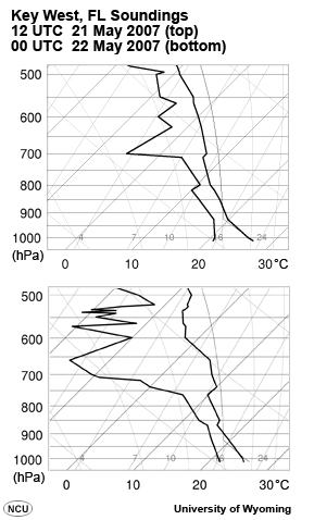
Description:
Key West, FL Soundings, 12 UTC 21 May 2007 and 00 UTC 22 May 2007
File Name:
keyw21may07.jpg
Credits:
University of Wyoming
Copyright Terms:
COMET Standard Terms
of Use
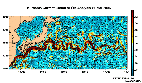
Description:
Map of Kuroshio Current. Global NLOM Analysis 1 Mar 2006
File Name:
kuroshio_nlom_1mar06.gif
Credits:
NAVOVEANO
Copyright Terms:
COMET Standard Terms
of Use
Description:
Map of Sea Surface Temperature ( C) near Kuroshio Current. MODAS Analysis 1 Mar 2006
File Name:
kuroshio_sst_1mar06.gif
Credits:
NAVOVEANO
Copyright Terms:
COMET Standard Terms
of Use
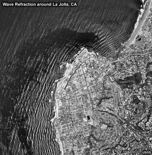
Description:
Aerial photograph of wave refraction around La Jolla, CA
File Name:
lajolla_wave_refraction.jpg
Credits:
USGS
Copyright Terms:
COMET Standard Terms
of Use
Description:
Animation showing how a column of air advecting over a warmer surface destabilizies, thickening the boundary layer, and mixing stronger winds to the surface.
File Name:
mbl_wind_wave.mp4
Credits:
©The COMET Program
Copyright Terms:
COMET Standard Terms
of Use
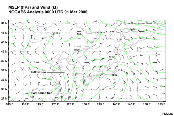
Description:
MSLP (hPa) and Wind (kt) NOGAPS Analysis 00 UTC 1 Mar 2006, East Asia
File Name:
mslp_wind_00z1mar06.gif
Credits:
FNMOC
Copyright Terms:
COMET Standard Terms
of Use
Description:
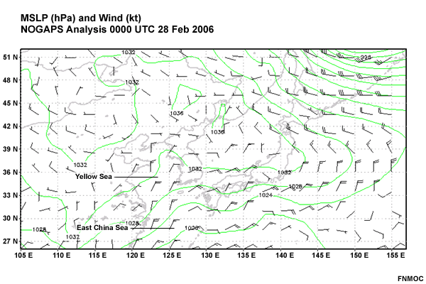
MSLP (hPa) and Wind (kt) NOGAPS Analysis 00 UTC 28 Feb 2006, East Asia
File Name:
mslp_wind_00z28feb06.gif
Credits:
FNMOC
Copyright Terms:
COMET Standard Terms
of Use
Description:
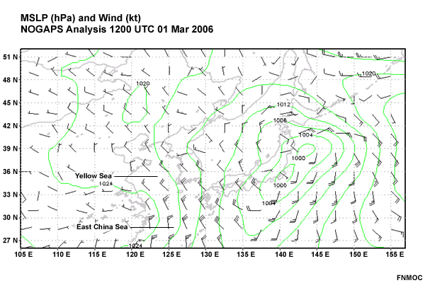
MSLP (hPa) and Wind (kt) NOGAPS Analysis 12 UTC 1 Mar 2006, East Asia
File Name:
mslp_wind_12z1mar06.gif
Credits:
FNMOC
Copyright Terms:
COMET Standard Terms
of Use
Description:
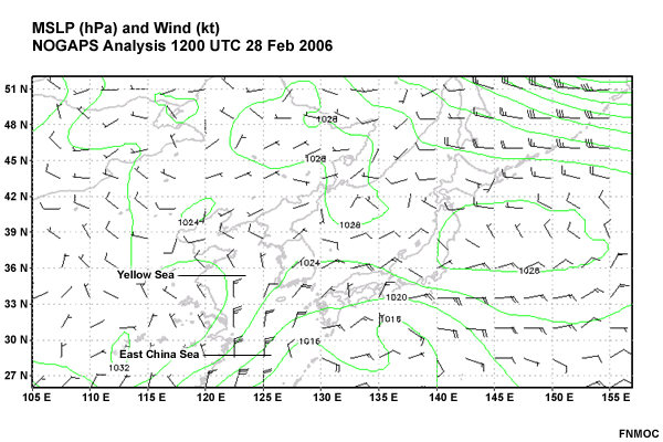
MSLP (hPa) and Wind (kt) NOGAPS Analysis 12 UTC 28 Feb 2006, East Asia
File Name:
mslp_wind_12z28feb06.gif
Credits:
FNMOC
Copyright Terms:
COMET Standard Terms
of Use
Description:
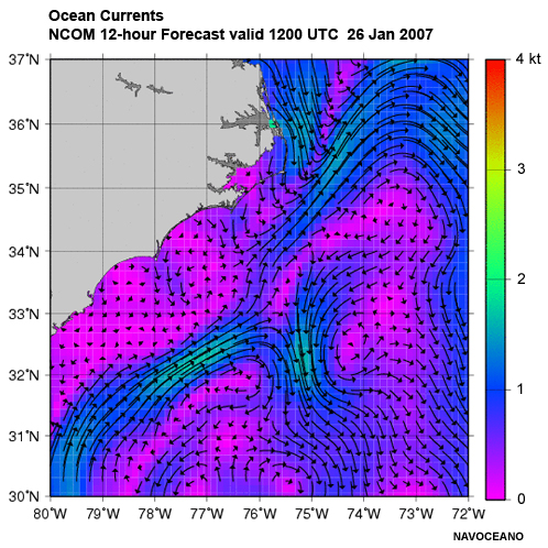
Ocean Currents
NCOM 12-hour Forecast valid 1200 UTC 26 Jan 2007
File Name:
ncom_currents_26jan2007.jpg
Credits:
NAVOCEANO
Copyright Terms:
COMET Standard Terms
of Use
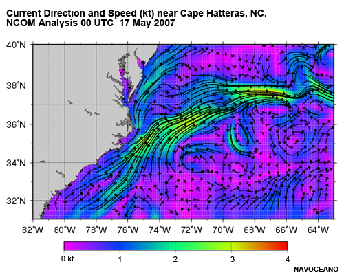
Description:
Current Direction and Speed (kt) near Cape Hatteras, NC. NCOM Analysis 00 UTC 17 May 2007
File Name:
ncom_gs_velocity.jpg
Credits:
NAVOCEANO
Copyright Terms:
COMET Standard Terms
of Use
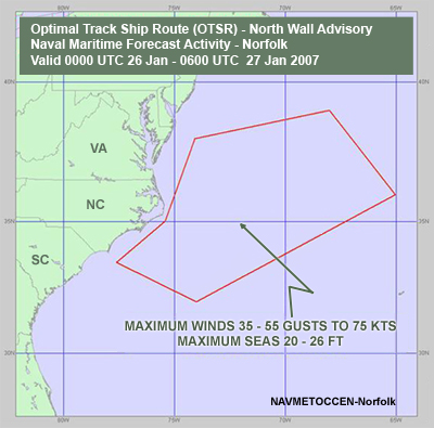
Description:
Optimal Track Ship Route (OTSR) - North Wall Advisory near Cape Hatteras, NC
Naval Maritime Forecast Activity - Norfolk
Valid 0000 UTC 26 Jan - 0600 UTC 27 Jan 2007
File Name:
northwall_advisory.jpg
Credits:
NAVMETOCCEN-Norfolk
Copyright Terms:
COMET Standard Terms
of Use
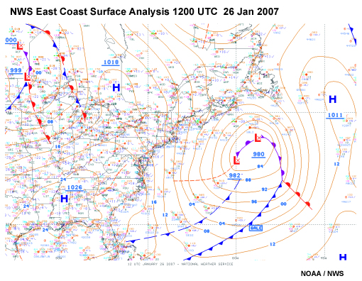
Description:
NWS East Coast Surface Analysis for 02-26-07 at 1200z
File Name:
nws_analysis_26jan07.jpg
Credits:
NOAA / NWS
Copyright Terms:
COMET Standard Terms
of Use
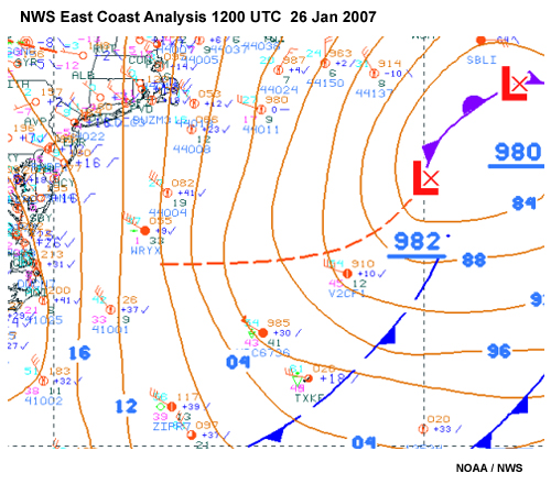
Description:
NWS East Coast Surface Analysis for 02-26-07 at 1200z
File Name:
nws_analysis_26jan07_zoom.jpg
Credits:
NOAA / NWS
Copyright Terms:
COMET Standard Terms
of Use
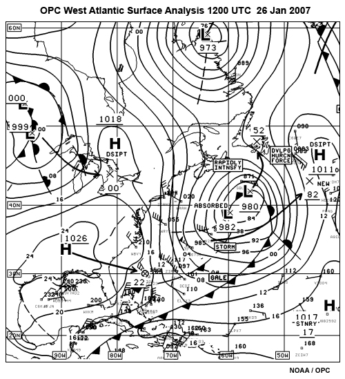
Description:
OPC West Atlantic Surface Analysis
1200 UTC 02-26-07
File Name:
opc_analysis_26jan07.jpg
Credits:
NOAA / OPC
Copyright Terms:
COMET Standard Terms
of Use
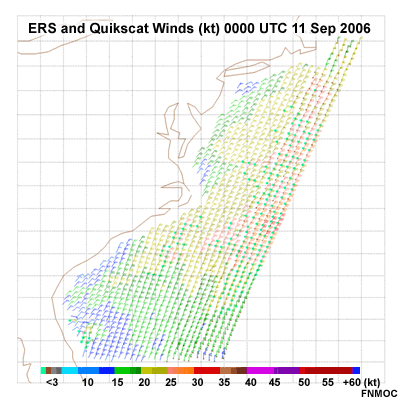
Description:
ERS and Quikscat Winds (kt) 00 UTC 11 Sep 2006 along U.S. East Coast
File Name:
quikscat_00z11sep06.gif
Credits:
FNMOC
Copyright Terms:
COMET Standard Terms
of Use
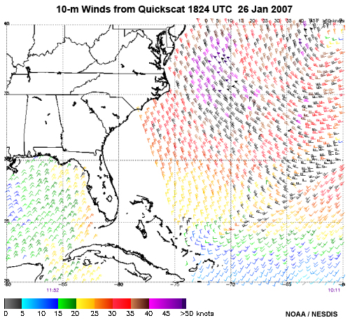
Description:
10-m Winds from Quikscat 1824 UTC 26 Jan 2007
File Name:
quikscat_26jan07.jpg
Credits:
NOAA / NESDIS
Copyright Terms:
COMET Standard Terms
of Use
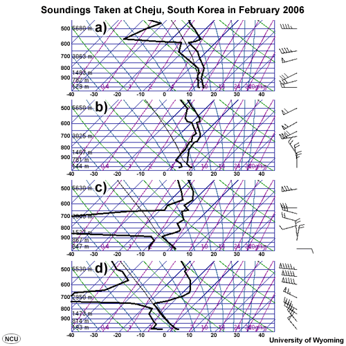
Description:
4 skewt diagrams from Cheju, S. Korea
File Name:
quiz_cheju_skewt.gif
Credits:
University of Wyoming
Copyright Terms:
COMET Standard Terms
of Use
Description:
Sounding at Newport, NC (MHX) 1800 UTC 26 Jan 2007
File Name:
raob_wal_12z26jan07.jpg
Credits:
NOAA / FSL
Copyright Terms:
COMET Standard Terms
of Use
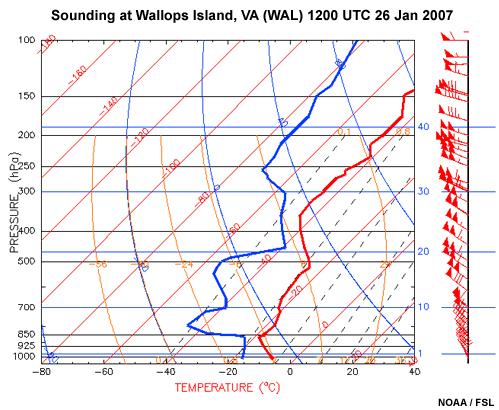
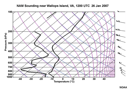
Description:
Sounding at Wallops Island, VA (WAL) 1200 UTC 26 Jan 2007
File Name:
raob_wal_12z26jan07.jpg
Credits:
NOAA / FSL
Copyright Terms:
COMET Standard Terms
of Use
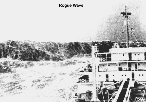
Description:
Photo of ship with huge wave astern
File Name:
rogue_wave.jpg
Credits:
NOAA
Copyright Terms:
COMET Standard Terms
of Use
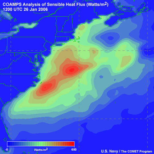
Description:
COAMPS Analysis of Sensible Heat Flux, Northwest Atlantic, 1200 UTC 26 Jan 2006
File Name:
sens_heat_12z26jan07.jpg
Credits:
U.S. Navy / The COMET Program
Copyright Terms:
COMET Standard Terms
of Use
Description:
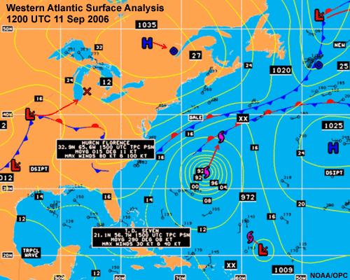
Western Atlantic Surface Analysis 12 UTC 11 Sep 2006
File Name:
sfc_anal_watl_11sep06.gif
Credits:
NOAA / OPC
Copyright Terms:
COMET Standard Terms
of Use
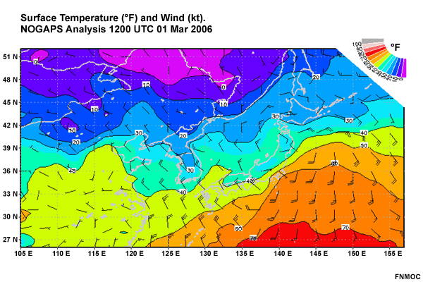
Description:
Surface Temperature (F) and Wind (kt), East Asia, NOGAPS Analysis 12 UTC 1 Mar 2006
File Name:
sfc_wind_temp_12z1mar06.gif
Credits:
FNMOC
Copyright Terms:
COMET Standard Terms
of Use
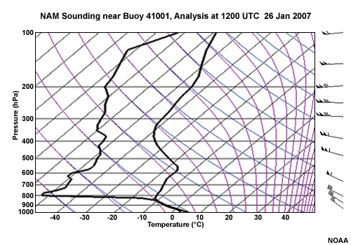
Description:
NAM model sounding for a location near Buoy 41001, Analysis 12z 26 jan 07
File Name:
skewt_buoy_nam_12z26jan07.gif
Credits:
NOAA
Copyright Terms:
COMET Standard Terms
of Use
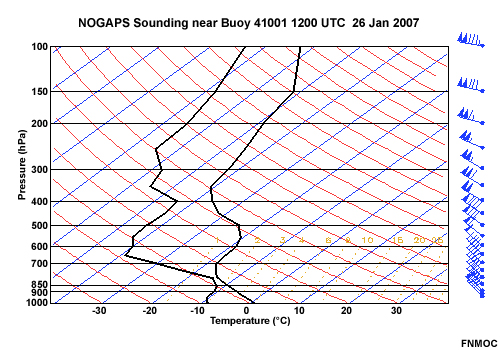
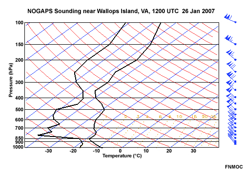
Description:
NOGAPS model sounding for a location near Buoy 41001 12z 26 jan 07
File Name:
skewt_buoy_nogaps_12z26jan07.jpg
Credits:
FNMOC
Copyright Terms:
COMET Standard Terms
of Use
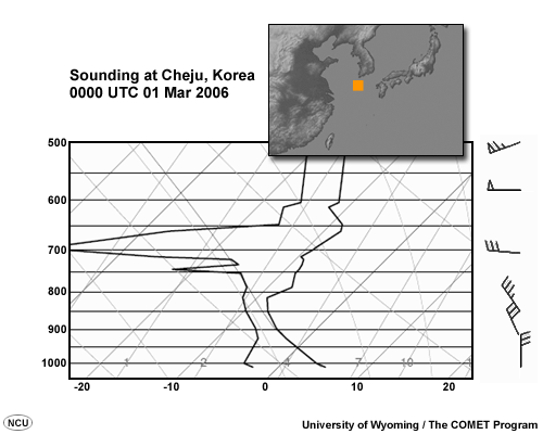
Description:
Sounding at Cheju, Korea, 00 UTC 01 Mar 2006
File Name:
skewt_cheju_00z01mar06.gif
Credits:
University of Wyoming / The COMET Program
Copyright Terms:
COMET Standard Terms
of Use
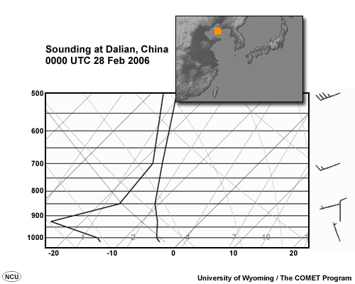
Description:
Sounding at Dalian, China, 00 UTC 28 Feb 2006
File Name:
skewt_dalian_00z28feb06.gif
Credits:
University of Wyoming / The COMET Program
Copyright Terms:
COMET Standard Terms
of Use
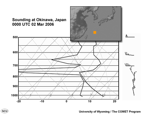
Description:
Sounding at Okinawa, Japan, 00 UTC 02 Mar 2006
File Name:
skewt_naha_00z02mar06.gif
Credits:
University of Wyoming / The COMET Program
Copyright Terms:
COMET Standard Terms
of Use
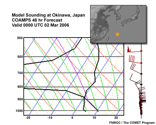
Description:
Model Sounding at Okinawa, Japan. COAMPS 48 hr Forecast valid 00 UTC 02 Mar 2006
File Name:
skewt_naha_coamps_00z02mar06.gif
Credits:
FNMOC / The COMET Program
Copyright Terms:
COMET Standard Terms
of Use
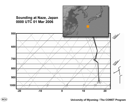
Description:
Sounding at Naze, Japan, 00 UTC 01 Mar 2006
File Name:
skewt_naze_00z01mar06.gif
Credits:
University of Wyoming / The COMET Program
Copyright Terms:
COMET Standard Terms
of Use

Description:
Sounding at Naze, Japan, 00 UTC 02 Mar 2006
File Name:
skewt_naze_00z02mar06.gif
Credits:
University of Wyoming / The COMET Program
Copyright Terms:
COMET Standard Terms
of Use
Description:
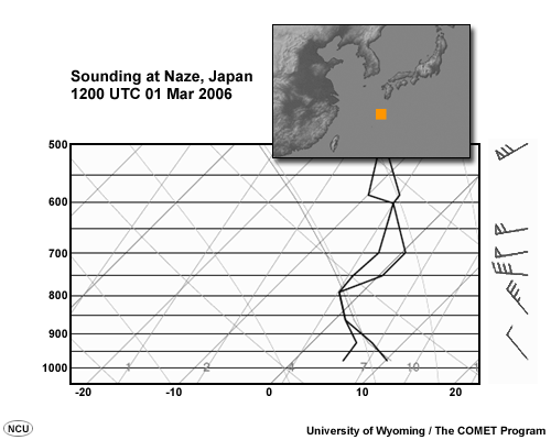
Sounding at Naze, Japan, 12 UTC 01 Mar 2006
File Name:
skewt_naze_12z01mar06.gif
Credits:
University of Wyoming / The COMET Program
Copyright Terms:
COMET Standard Terms
of Use
Description:
NAM model sounding for a location near Wallops Island, VA, 12z 26 jan 07
File Name:
skewt_wal_nam_12z26jan07.gif
Credits:
NOAA
Copyright Terms:
COMET Standard Terms
of Use
Description:
NOGAPS model sounding for a location near Wallops Island, VA, 12z 26 jan 07
File Name:
skewt_wal_nogaps_12z26jan07.jpg
Credits:
FNMOC
Copyright Terms:
COMET Standard Terms
of Use
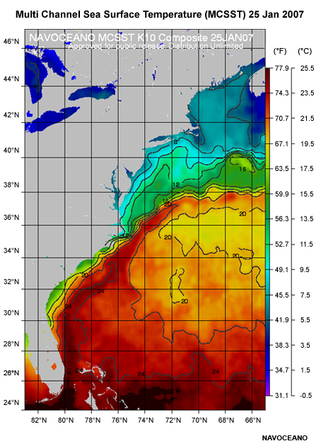
Description:
Multi Channel Sea Surface Temperature MCSST composite from NAVOCEANO 25 Jan 2007
File Name:
sst_25jan2007.jpg
Credits:
NAVOCEANO
Copyright Terms:
COMET Standard Terms
of Use
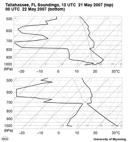
Description:
Tallahassee, FL Soundings, 12 UTC 21 May 2007 and 00 UTC 22 May 2007
File Name:
tlh21may07.jpg
Credits:
University of Wyoming
Copyright Terms:
COMET Standard Terms
of Use
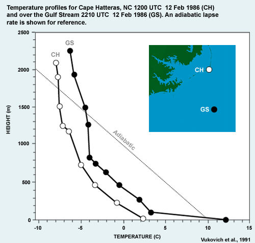
Description:
Temperature profiles for Cape Hatteras, NC 1200 UTC 12 Feb 1986 and over the Gulf Stream 2210 UTC 12 Feb 1986.
File Name:
vukovich91fig10.gif
Credits:
Vukovich et al., 1991
Copyright Terms:
COMET Standard Terms
of Use
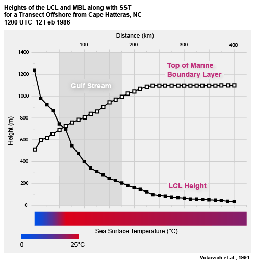
Description:
Heights of the LCL and MBL along with SST for a Transect Offshore from Cape Hatteras, NC
1200 UTC 12 Feb 1986
File Name:
vukovich91fig12.gif
Credits:
Vukovich et al., 1991
Copyright Terms:
COMET Standard Terms
of Use
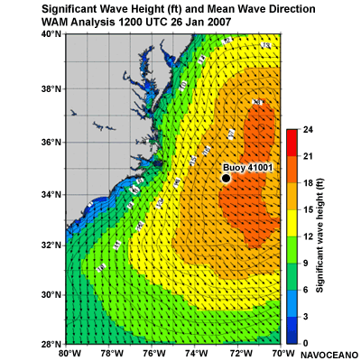
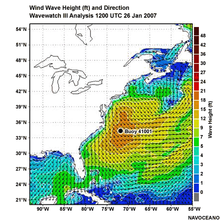
Description:
Significant Wave Height (ft) and Mean Wave Direction
WAM Analysis 1200 UTC 26 Jan 2007
File Name:
wam_12z26Jan07.gif
Credits:
NAVOCEANO
Copyright Terms:
COMET Standard Terms
of Use
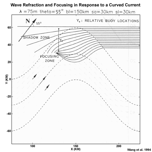
Description:
Diagram showing Wave Refraction and Focusing in Response to a Curved Current
File Name:
wang94_waverefrac.gif
Credits:
Wang et al. 1994
Copyright Terms:
COMET Standard Terms
of Use
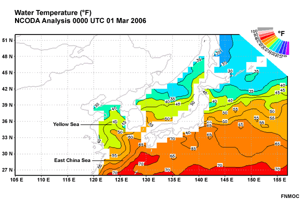
Description:
Water Temperature ( F). NCODA Analysis 00 UTC 1 Mar 2006, East Asia
File Name:
water_temp_00z1mar06.gif
Credits:
FNMOC
Copyright Terms:
COMET Standard Terms
of Use
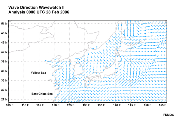
Description:
Wave Direction. Wave Watch III Analysis 00 UTC 28 Feb 2006, East Asia
File Name:
wave_dir_00z28feb06.gif
Credits:
FNMOC
Copyright Terms:
COMET Standard Terms
of Use
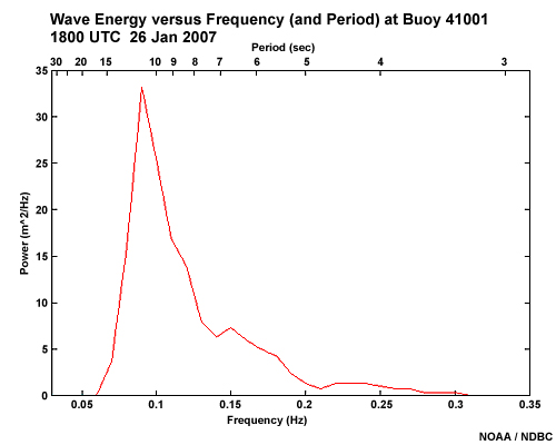
Description:
Wave Energy versus Frequency (and Period) at Buoy 41001, 150 nm east of Cape Hatteras
1800 UTC 26 Jan 2007
File Name:
wave_energy_spectrum_18z26jan07.jpg
Credits:
NOAA / NDBC
Copyright Terms:
COMET Standard Terms
of Use
Description:
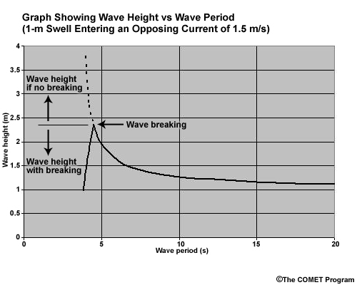
Graph showing wave height versus wave period for a 1-m swell entering an opposing current of 1.5 m/s
File Name:
wave_height_graph.jpg
Credits:
©The COMET Program
Copyright Terms:
COMET Standard Terms
of Use
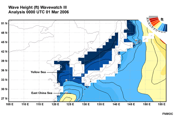
Description:
Wave Height (ft). Wave Watch III Analysis 00 UTC 1 Mar 2006, East Asia
File Name:
wave_ht_00z1mar06.gif
Credits:
FNMOC
Copyright Terms:
COMET Standard Terms
of Use
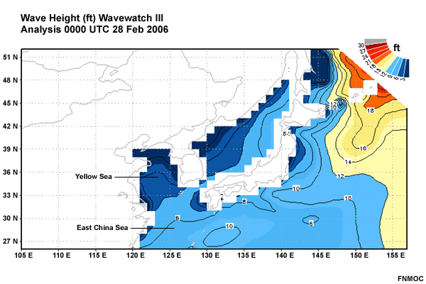
Description:
Wave Height (ft). Wave Watch III Analysis 00 UTC 28 Feb 2006, East Asia
File Name:
wave_ht_00z28feb06.gif
Credits:
FNMOC
Copyright Terms:
COMET Standard Terms
of Use
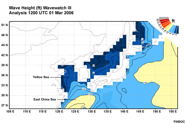
Description:
Wave Height (ft). Wave Watch III Analysis 12 UTC 1 Mar 2006, East Asia
File Name:
wave_ht_12z1mar06.gif
Credits:
FNMOC
Copyright Terms:
COMET Standard Terms
of Use
Description:
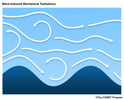
Conceptual drawing of wind streamlines over ocean waves showing mechanical turbulence
File Name:
wave_turbulance.jpg
Credits:
©The COMET Program
Copyright Terms:
COMET Standard Terms
of Use
Description:
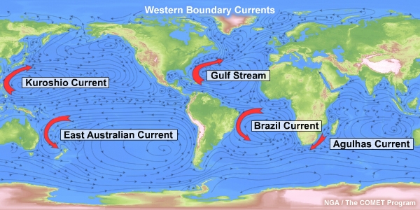
Western boundary currents
File Name:
wbc.jpg
Credits:
NGA / The COMET Program
Copyright Terms:
COMET Standard Terms
of Use
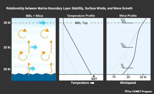
Description:
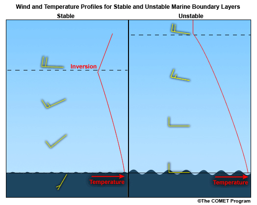
Wind and Temperature Profiles for Stable and Unstable Marine Boundary Layers
File Name:
wind_stability.jpg
Credits:
©The COMET Program
Copyright Terms:
COMET Standard Terms
of Use
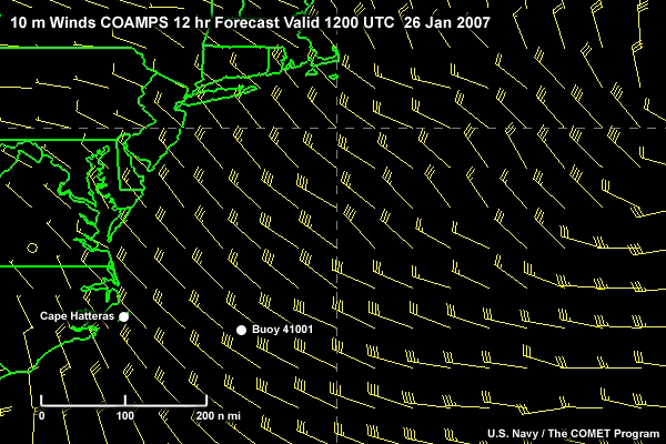
Description:
10-m winds over the US east coast and western Atlantic Ocean. COAMPS 12-hr Forecast valid 1200 UTC 26 Jan 2007
File Name:
wind10m_coamps_12z26jan07.jpg
Credits:
U.S. Navy / The COMET Program
Copyright Terms:
COMET Standard Terms
of Use
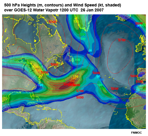
Description:
500 hPa Heights (m, contours) and Wind Speed (kt, shaded) over GOES-12 Water Vapor
1200 UTC 01-26-07
File Name:
windht500_wv.jpg
Credits:
FNMOC
Copyright Terms:
COMET Standard Terms
of Use
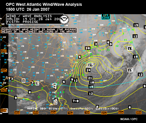
Description:
OPC West Atlantic Wind/Wave Analysis
1500 UTC 02-26-07
File Name:
windwave_analysis_26jan07.jpg
Credits:
NOAA / OPC
Copyright Terms:
COMET Standard Terms
of Use
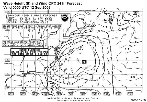
Description:
Wave Height (ft) and Wind OPC 24 hr Forecast valid 00 UTC 12 Sep 2006 in the western Atlantic
File Name:
windwave_watl_00z12sep06.gif
Credits:
NOAA / OPC
Copyright Terms:
COMET Standard Terms
of Use
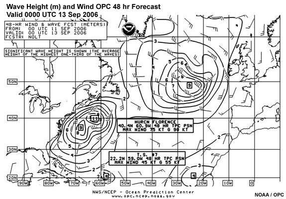
Description:
Wave Height (ft) and Wind OPC 48 hr Forecast valid 00 UTC 13 Sep 2006 in the western Atlantic
File Name:
windwave_watl_00z13sep06.gif
Credits:
NOAA / OPC
Copyright Terms:
COMET Standard Terms
of Use
Description:
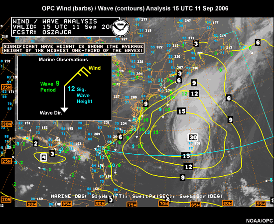
Western Atlantic Wind / Wave Analysis 15 UTC 11 Sep 2006
File Name:
windwave_watl_15z11sep06.gif
Credits:
NOAA / OPC
Copyright Terms:
COMET Standard Terms
of Use
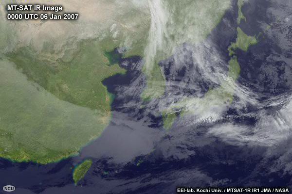
Description:
Loop of IR Satellite images over Eastern Asia/Western Pacific 00 UTC 6 Jan to 12 UTC 7 Jan 2007
File Name:
wpac_ir_jan070001.htm
Credits:
EEl-lab. Kochi Univ. / MTSAT-1R IR1 JMA / NASA
Copyright Terms:
COMET Standard Terms
of Use
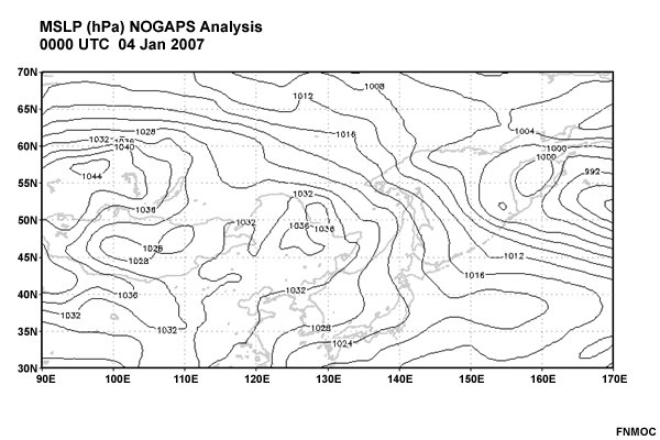
Description:
Loop of MSLP over Eastern Asia/Western Pacific 00 UTC 4 Jan to 00 UTC 7 Jan 2007
File Name:
wpac_mslp_jan070001.htm
Credits:
FNMOC
Copyright Terms:
COMET Standard Terms
of Use
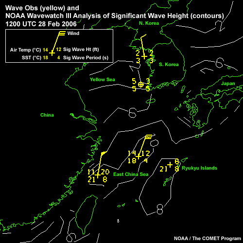
Description:
Loop of Waves in the Yellow and East China Seas: Ship/Buoy Obs (yellow) and NOAA WaveWatchIII Analysis (cyan), 1200 UTC 28 Feb 2006 to 0000 UTC 02 Mar 2006
File Name:
wpac_wave_nww3_obs_mar060001.htm
Credits:
NOAA / The COMET Program
Copyright Terms:
COMET Standard Terms
of Use
Description:
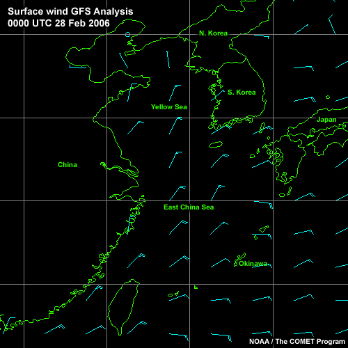
Loop of Winds in the Yellow and East China Seas: GFS Analysis (cyan), 0000 UTC 28 Feb 2006 to 1200 UTC 01 Mar 2006
File Name:
wpac_wind_gfs_mar060001.htm
Credits:
NOAA / The COMET Program
Copyright Terms:
COMET Standard Terms
of Use
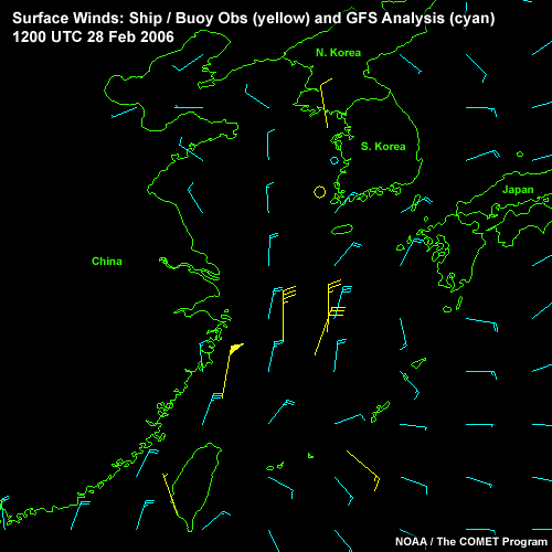
Description:
Loop of Surface Winds over the Yellow and East China Seas: Ship/Buoy Obs (yellow) and GFS Analysis (cyan), 1200 UTC 28 Feb 2006 to 1200 UTC 01 Mar 2006
File Name:
wpac_wind_gfs_obs_mar060001.htm
Credits:
NOAA / The COMET Program
Copyright Terms:
COMET Standard Terms
of Use
Description:
Wind Wave Height (ft) and Direction
Wave Watch III Analysis 1200 UTC 26 Jan 2007
File Name:
ww3_12z26jan07.gif
Credits:
NAVOCEANO
Copyright Terms:
COMET Standard Terms
of Use
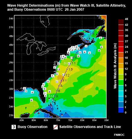
Description:
Comparison of Wave Height Determinations from Wave Watch III, Satellite Altimetry, and Buoy Observations 0600 UTC 26 Jan 2007 in the Western Atlantic
File Name:
ww3_altimeter_buoy.jpg
Credits:
FNMOC
Copyright Terms:
COMET Standard Terms
of Use
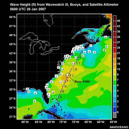
Description:
Wave Height (ft) from Wave Watch III (shaded), Buoys (white labels), and Satellite Altimeter (dotted line) 0600 UTC 26 Jan 2007
File Name:
ww3_buoy_6z26jan07.gif
Credits:
NAVOCEANO
Copyright Terms:
COMET Standard Terms
of Use
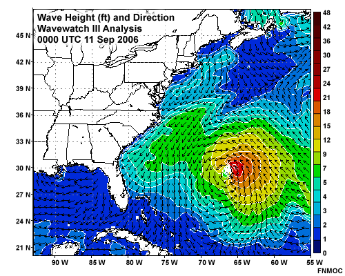
Description:
Wave Height (ft) and Direction Wave Watch III Analysis 00 UTC 11 Sep 2006 in the western Atlantic
File Name:
ww3_watl_00z11sep06.gif
Credits:
FNMOC
Copyright Terms:
COMET Standard Terms
of Use
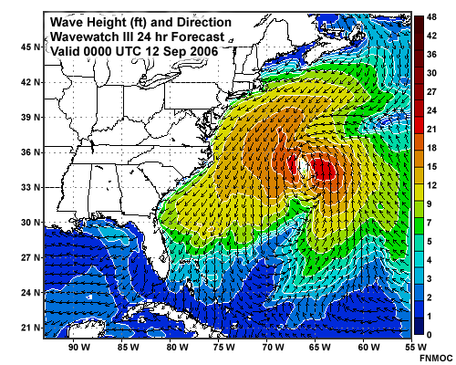
Description:
Wave Height (ft) and Direction Wave Watch III 24 hr Forecast valid 00 UTC 12 Sep 2006 in the western Atlantic
File Name:
ww3_watl_00z12sep06.gif
Credits:
FNMOC
Copyright Terms:
COMET Standard Terms
of Use