Media elements used in this module are protected by a variety of copyright licenses. Please use the "copyright terms" link associated with each item below for more information.
Description:
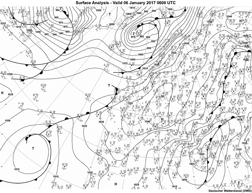
Deutscher Wetterdienst (DWD) analysis valid at 06 UTC on January 6, 2017.
File Name:
17010600_DWD_Analyse.jpg
Credits:
Deutscher Wetterdienst (DWD)
Copyright Terms:
COMET Standard Terms of Use
Description:
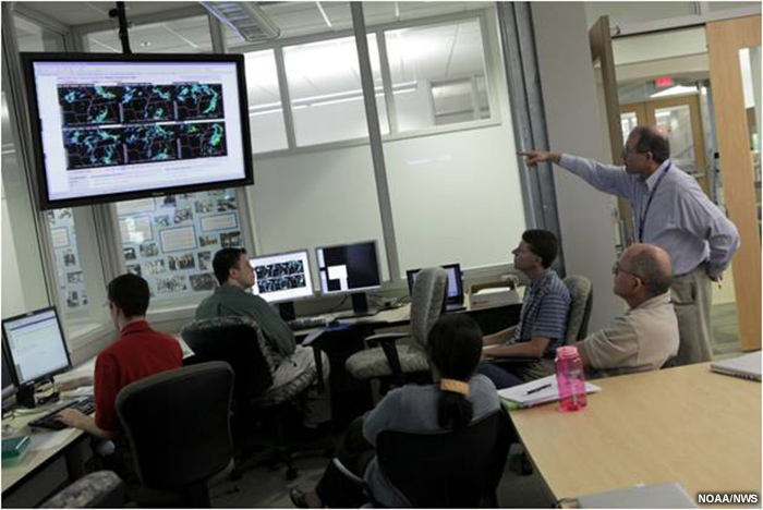
Meteorologists discussing multiple ensemble-generated radar echoes.
File Name:
2012_testbed_fcsters.jpg
Credits:
NOAA/NWS
Copyright Terms:
COMET Standard Terms of Use
Description:
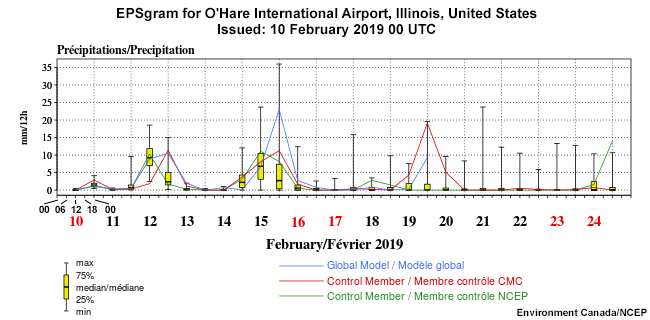
EPSgram for precipitation (mm per 12 hours) for O'Hare International Airport, Illinois initialized 00 UTC 10 February 2019.
File Name:
2019021000_ord_epsgram_pcp.jpg
Credits:
Environment Canada/NCEP
Copyright Terms:
COMET Standard Terms of Use
Description:
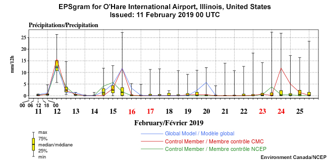
EPSgram for precipitation (mm per 12 hours) for O'Hare International Airport, Illinois initialized 00 UTC 11 February 2019.
File Name:
2019021100_ord_epsgram_pcp.jpg
Credits:
Environment Canada/NCEP
Copyright Terms:
COMET Standard Terms of Use
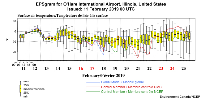
Description:
EPSgram for surface air temperature (Celsius per 6 hours) for O'Hare International Airport, Illinois initialized 00 UTC 11 February 2019.
File Name:
2019021100_ord_epsgram_temp.jpg
Credits:
Environment Canada/NCEP
Copyright Terms:
COMET Standard Terms of Use
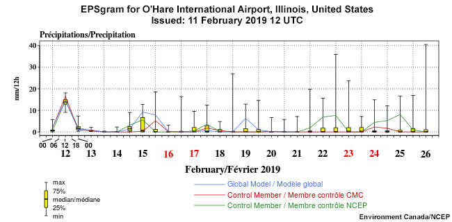
Description:
EPSgram for precipitation (mm per 12 hours) for O'Hare International Airport, Illinois initialized 12 UTC 11 February 2019.
File Name:
2019021112_ord_epsgram_pcp.jpg
Credits:
Environment Canada/NCEP
Copyright Terms:
COMET Standard Terms of Use
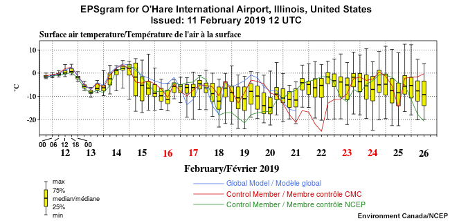
Description:
EPSgram for surface air temperature (Celsius per 6 hours) for O'Hare International Airport, Illinois initialized 12 UTC 11 February 2019.
File Name:
2019021112_ord_epsgram_temp.jpg
Credits:
Environment Canada/NCEP
Copyright Terms:
COMET Standard Terms of Use
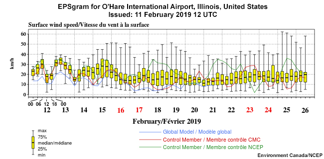
Description:
EPSgram for surface wind speed (km/h per 6 hours) for O'Hare International Airport, Illinois initialized 12 UTC 11 February 2019.
File Name:
2019021112_ord_epsgram_wind.jpg
Credits:
Environment Canada/NCEP
Copyright Terms:
COMET Standard Terms of Use
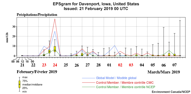
Description:
EPSgram for precipitation (mm per 12 hours) for Davenport, Iowa initialized 00 UTC 21 February 2019.
File Name:
2019022100_dvn_epsgram_pcp.jpg
Credits:
Environment Canada/NCEP
Copyright Terms:
COMET Standard Terms of Use
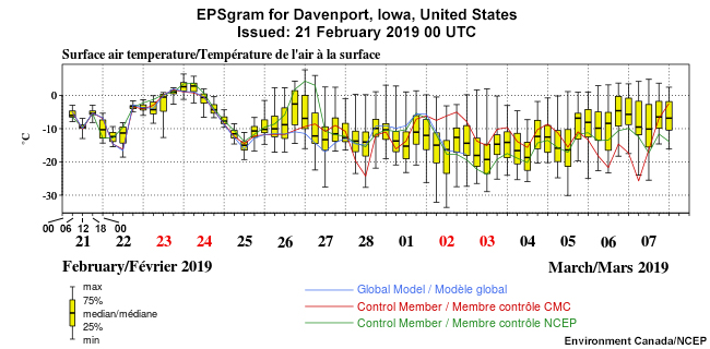
Description:
EPSgram for surface air temperature (Celsius per 6 hours) for Davenport, Iowa initialized 00 UTC 21 February 2019.
File Name:
2019022100_dvn_epsgram_temp.jpg
Credits:
Environment Canada/NCEP
Copyright Terms:
COMET Standard Terms of Use
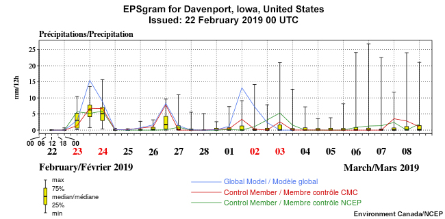
Description:
EPSgram for precipitation (mm per 12 hours) for Davenport, Iowa initialized 00 UTC 22 February 2019.
File Name:
2019022200_dvn_epsgram_pcp.jpg
Credits:
Environment Canada/NCEP
Copyright Terms:
COMET Standard Terms of Use
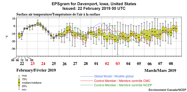
Description:
EPSgram for surface air temperature (Celsius per 6 hours) for Davenport, Iowa initialized 00 UTC 22 February 2019.
File Name:
2019022200_dvn_epsgram_temp.jpg
Credits:
Environment Canada/NCEP
Copyright Terms:
COMET Standard Terms of Use
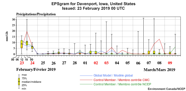
Description:
EPSgram for precipitation (mm per 12 hours) for Davenport, Iowa initialized 00 UTC 23 February 2019.
File Name:
2019022300_dvn_EPSGRAMS_pcp.jpg
Credits:
Environment Canada/NCEP
Copyright Terms:
COMET Standard Terms of Use
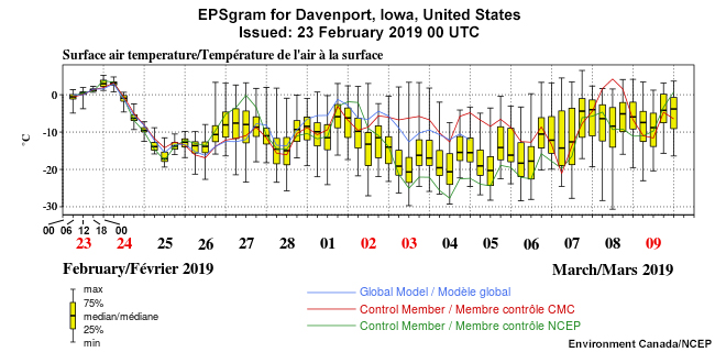
Description:
EPSgram for surface air temperature (Celsius per 6 hours) for Davenport, Iowa initialized 00 UTC 23 February 2019.
File Name:
2019022300_dvn_EPSGRAMS_temp.jpg
Credits:
Environment Canada/NCEP
Copyright Terms:
COMET Standard Terms of Use
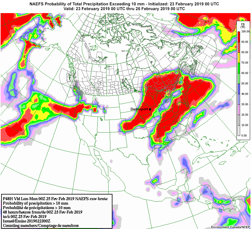
Description:
NAEFS probability of exceedance for 10 mm of total precipitation initialized on 23 February 2019 at 00 UTC and valid for the period 23 February 2019 00 UTC through 25 February 2019 00 UTC.
File Name:
2019022300_poe10.jpg
Credits:
Environment Canada/NCEP
Copyright Terms:
COMET Standard Terms of Use
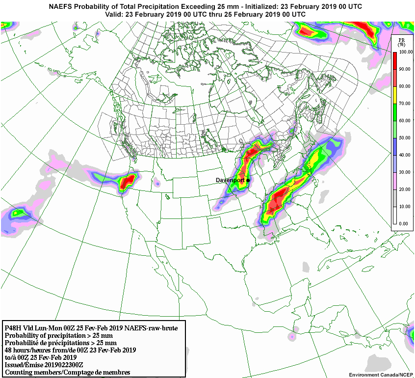
Description:
NAEFS probability of exceedance for 25 mm of total precipitation initialized on 23 February 2019 at 00 UTC and valid for the period 23 February 2019 00 UTC through 25 February 2019 00 UTC.
File Name:
2019022300_poe25.jpg
Credits:
Environment Canada/NCEP
Copyright Terms:
COMET Standard Terms of Use
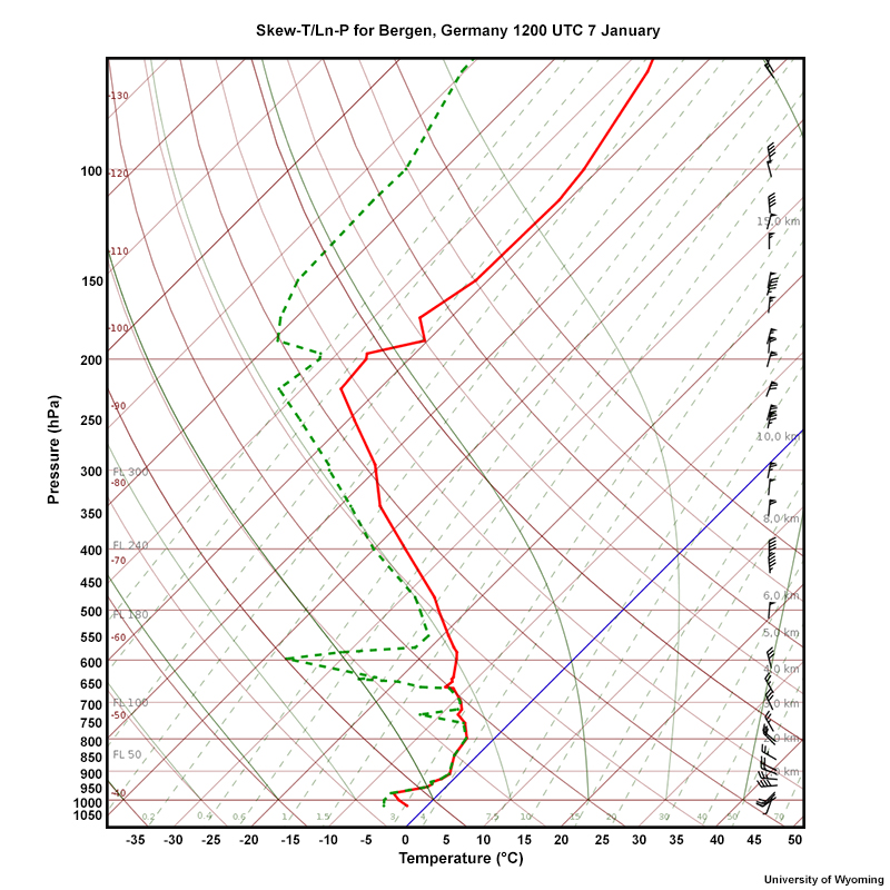
Description:
Skew-T/ln-P for Bergen Germany, 12 UTC 7 January.
File Name:
Bergen070117_12UTC.jpg
Credits:
University of Wyoming
Copyright Terms:
COMET Standard Terms of Use
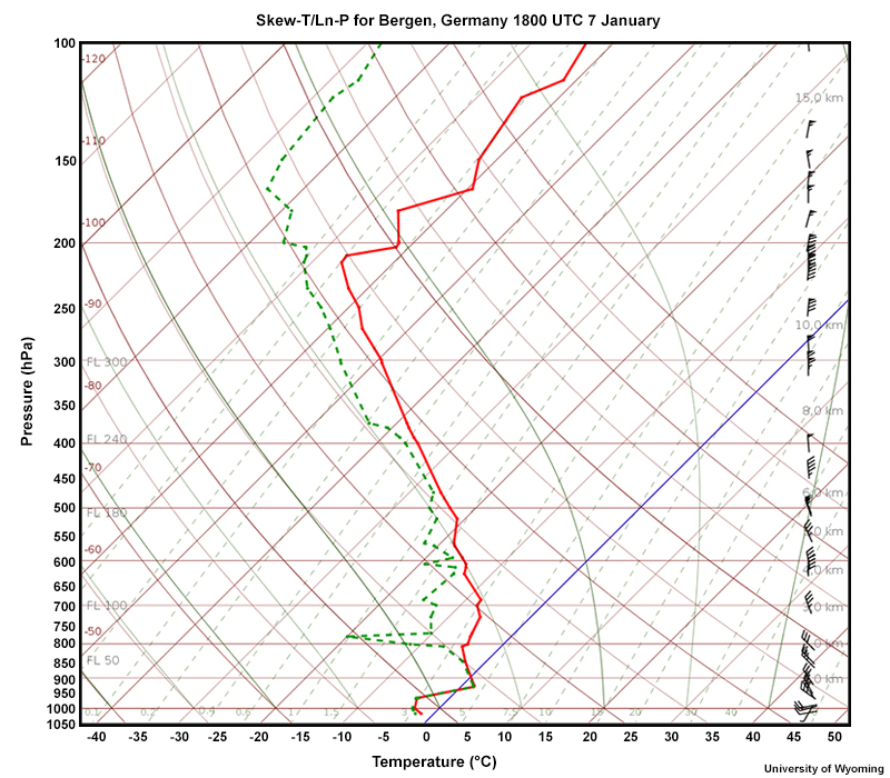
Description:
Skew-T/ln-P for Bergen Germany, 18 UTC 7 January.
File Name:
Bergen070117_18UTC.jpg
Credits:
University of Wyoming
Copyright Terms:
COMET Standard Terms of Use
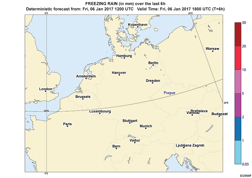
Description:
A loop of deterministic freezing rain QPFs, initialized 12Z on 6 January with forecast hours every 6 hours through 12Z 9 January (hours 00 - 72).
File Name:
day1_fzrn_qpf.htm
Credits:
ECMWF
Copyright Terms:
COMET Standard Terms of Use
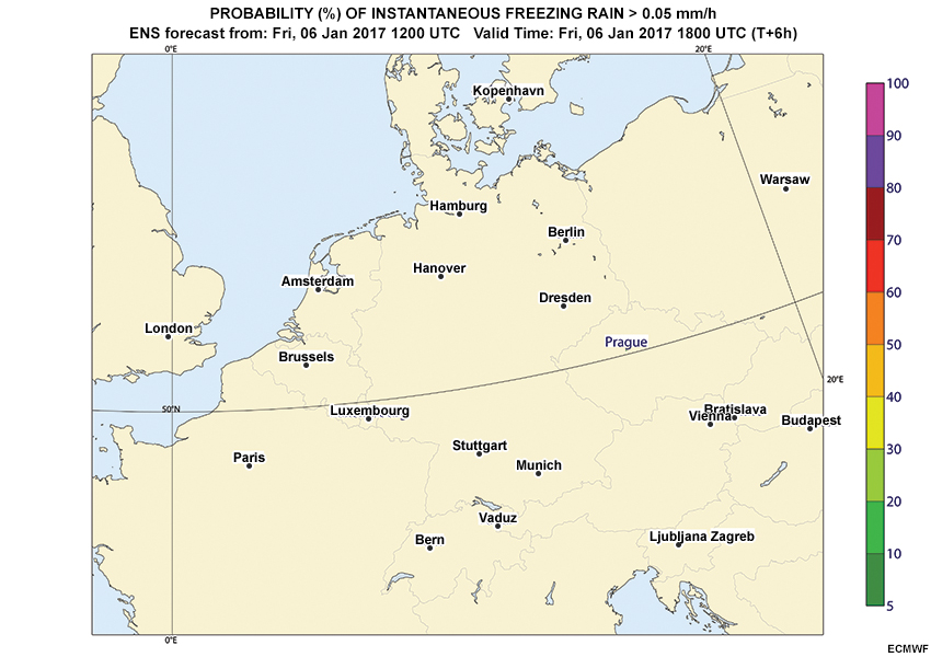
Description:
A loop of the probability of instantaneous freezing rain exceeding 0.05 mm/h, initialized 12Z on 6 January with forecast hours every 6 hours through 12Z 9 January (hours 00 - 72).
File Name:
day1_prob_fzrn.htm
Credits:
ECMWF
Copyright Terms:
COMET Standard Terms of Use
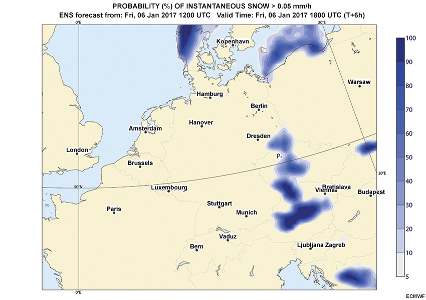
Description:
A loop of the probability of instantaneous snow exceeding 0.05 mm/h, initialized 12Z on 6 January with forecast hours every 6 hours through 12Z 9 January (hours 00 - 72).
File Name:
day1_prob_snow.htm
Credits:
ECMWF
Copyright Terms:
COMET Standard Terms of Use
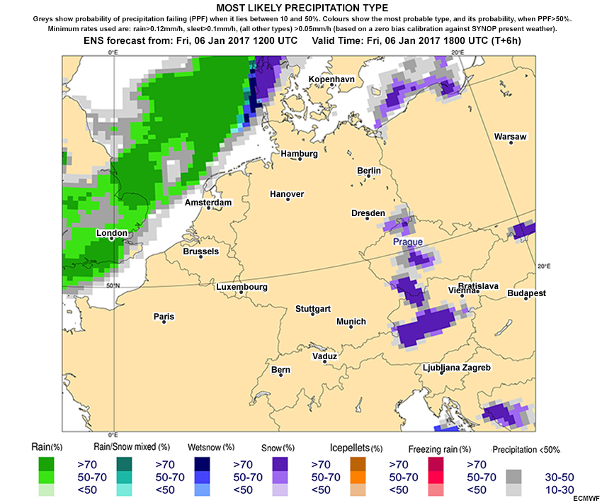
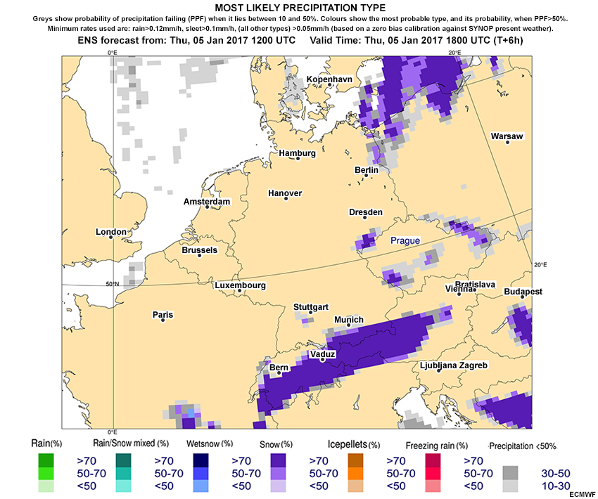
Description:
A loop of the ENS most likely precipitation type, initialized 12Z on 6 January with forecast hours every 6 hours through 12Z 9 January (hours 00 - 72).
File Name:
day1_probable_ptype.htm
Credits:
ECMWF
Copyright Terms:
COMET Standard Terms of Use
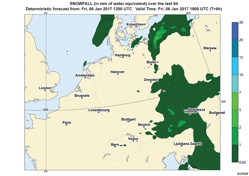
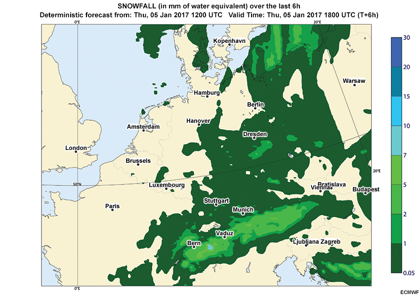
Description:
A loop of deterministic snow QPFs, initialized 12Z on 6 January with forecast hours every 6 hours through 12Z 9 January (hours 00 - 72).
File Name:
day1_snow_qpf.htm
Credits:
ECMWF
Copyright Terms:
COMET Standard Terms of Use

Description:
A loop of deterministic freezing rain QPFs, initialized 12Z on 5 January with forecast hours every 6 hours through 12Z 9 January (hours 00 - 96)
File Name:
day2_fzrn_qpf.htm
Credits:
ECMWF
Copyright Terms:
COMET Standard Terms of Use

Description:
A loop of the probability of instantaneous freezing rain exceeding 0.05 mm/h, initialized 12Z on 5 January with forecast hours every 6 hours through 12Z 9 January (hours 00 - 96).
File Name:
day2_prob_fzrn.htm
Credits:
ECMWF
Copyright Terms:
COMET Standard Terms of Use
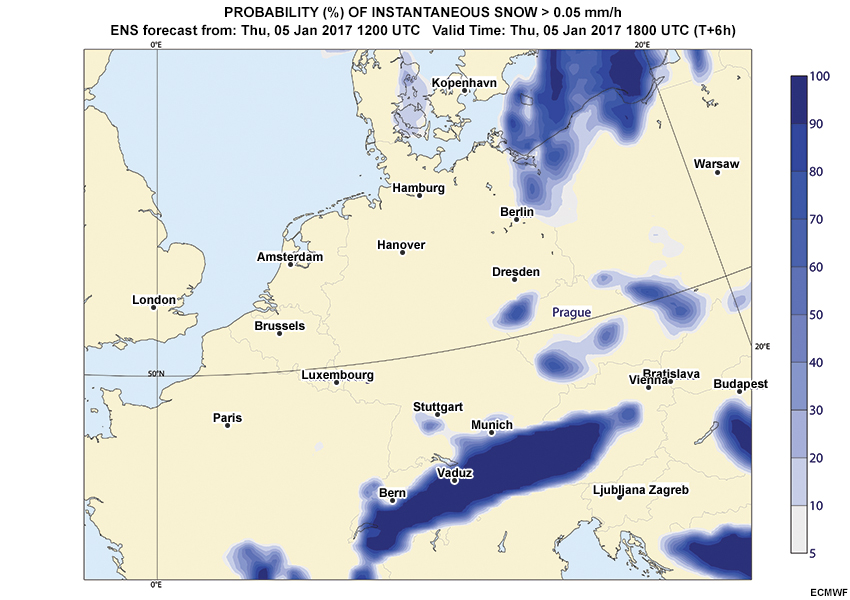
Description:
A loop of the probability of instantaneous snow exceeding 0.05 mm/h, initialized 12Z on 5 January with forecast hours every 6 hours through 12Z 9 January (hours 00 - 96).
File Name:
day2_prob_snow.htm
Credits:
ECMWF
Copyright Terms:
COMET Standard Terms of Use
Description:
A loop of the ENS most likely precipitation type, initialized 12Z on 5 January with forecast hours every 6 hours through 12Z 9 January (hours 00 - 96).
File Name:
day2_probable_ptype.htm
Credits:
ECMWF
Copyright Terms:
COMET Standard Terms of Use
Description:
A loop of deterministic snow QPFs, initialized 12Z on 5 January with forecast hours every 6 hours through 12Z 9 January (hours 00 - 96)
File Name:
day2_snow_qpf.htm
Credits:
ECMWF
Copyright Terms:
COMET Standard Terms of Use
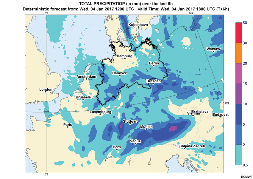
Description:
A loop of deterministic total QPFs, initialized 12Z on 4 January with forecast hours every 6 hours through 12Z 9 January (hours 00 - 120)
File Name:
day3_total_qpf.htm
Credits:
ECMWF
Copyright Terms:
COMET Standard Terms of Use
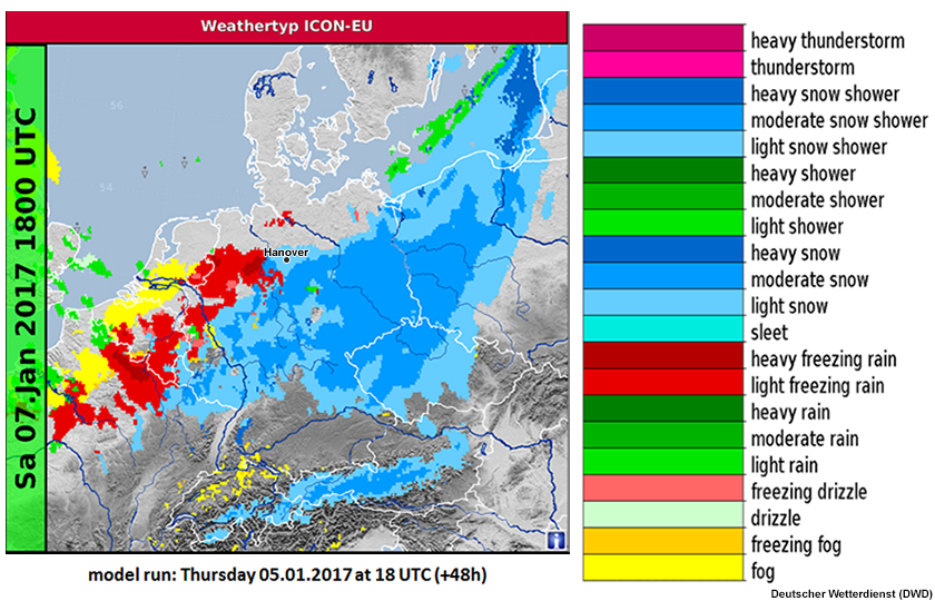
Description:
ICON-EU global model 48-hour deterministic forecast of precipitation type initialized 18 UTC on January 5, 2017.
File Name:
determ_ptype_050117_18UTC_48h.jpg
Credits:
Deutscher Wetterdienst (DWD)
Copyright Terms:
COMET Standard Terms of Use
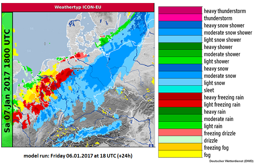
Description:
ICON-EU global model 24-hour deterministic forecast of precipitation type initialized 18Z on 6 January.
File Name:
determ_ptype_060117_18UTC_24h.jpg
Credits:
Deutscher Wetterdienst (DWD)
Copyright Terms:
COMET Standard Terms of Use
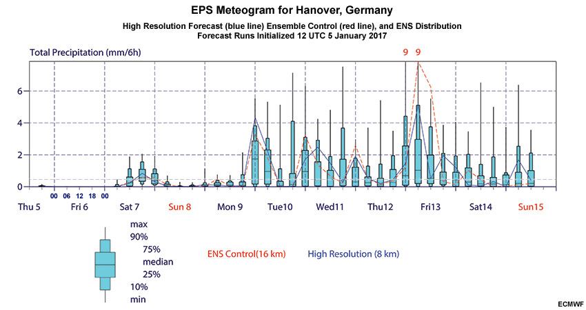
Description:
High Resolution Forecast and Ensemble Prediction System Box and Whisker diagram (EPSgram) for total precipitation (mm per 6 hours) for Hannover, Germany initialized 12Z on 5 January.
File Name:
epsgrams_2017010512_Hannover_pcp.jpg
Credits:
ECMWF
Copyright Terms:
COMET Standard Terms of Use
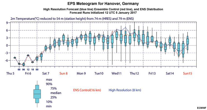
Description:
High Resolution Forecast and Ensemble Prediction System Box and Whisker diagram (EPSgram) for 2-meter temperature (degrees Celsius) for Hannover, Germany initialized 12Z on 5 January.
File Name:
epsgrams_2017010512_Hannover_temp.jpg
Credits:
ECMWF
Copyright Terms:
COMET Standard Terms of Use
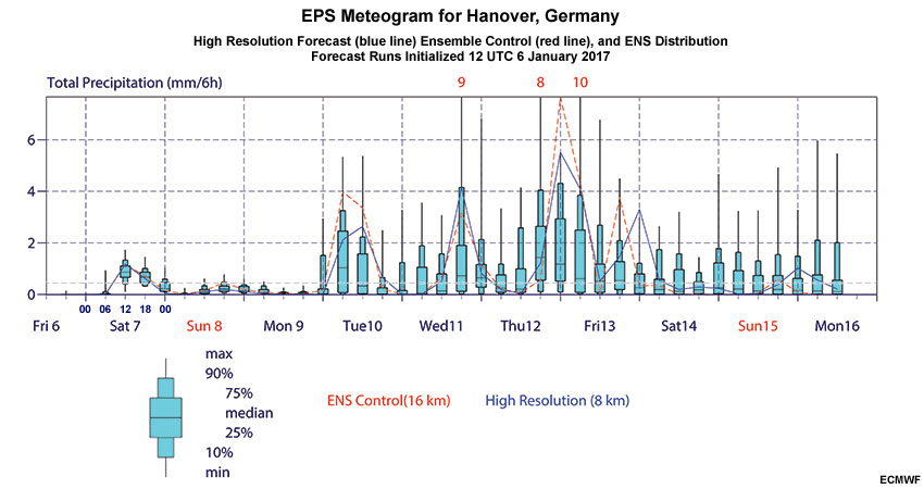
Description:
High Resolution Forecast and Ensemble Prediction System Box and Whisker diagram (EPSgram) for total precipitation (mm per 6 hours) for Hannover, Germany initialized 12Z on 6 January.
File Name:
epsgrams_2017010612_Hannover_pcp.jpg
Credits:
ECMWF
Copyright Terms:
COMET Standard Terms of Use
Description:
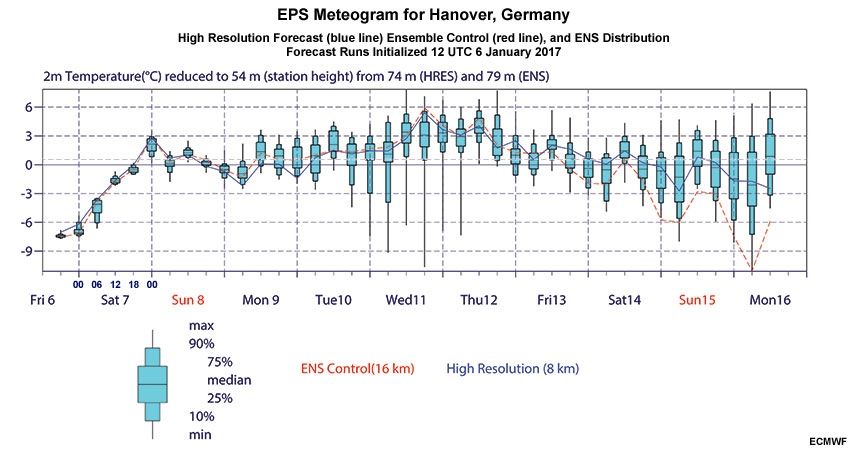
High Resolution Forecast and Ensemble Prediction System Box and Whisker diagram (EPSgram) for 2-meter temperature (degrees Celsius) for Hannover, Germany initialized 12Z on 6 January.
File Name:
epsgrams_2017010612_Hannover_temp.jpg
Credits:
ECMWF
Copyright Terms:
COMET Standard Terms of Use
Description:
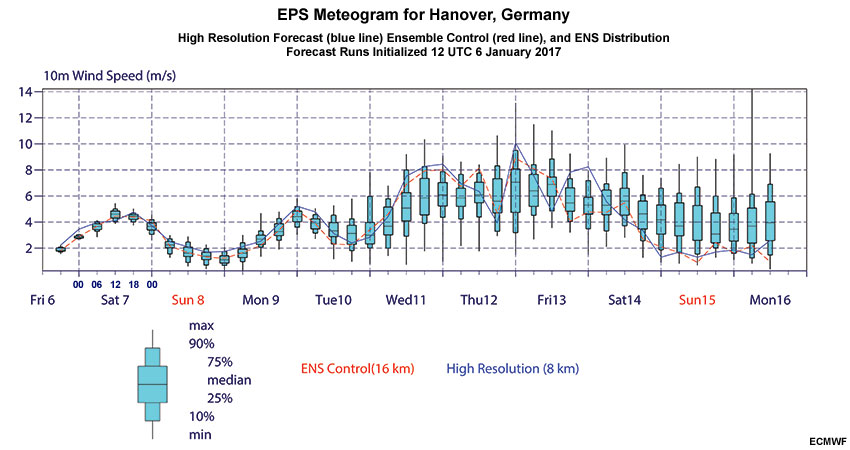
High Resolution Forecast and Ensemble Prediction System Box and Whisker diagram (EPSgram) for 2-meter temperature (degrees Celsius) for Hannover, Germany initialized 12Z on 6 January.
File Name:
epsgrams_2017010612_Hannover_wspd.jpg
Credits:
ECMWF
Copyright Terms:
COMET Standard Terms of Use
Description:
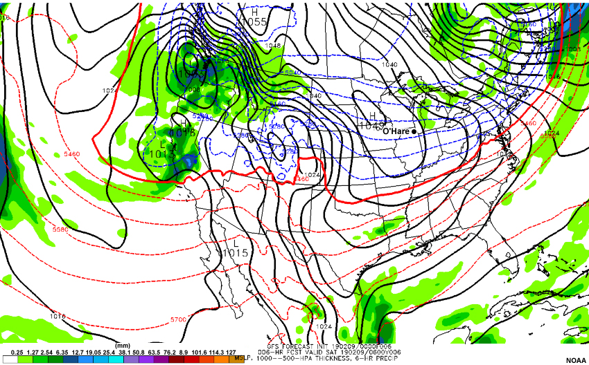
A loop of the GFS model forecast of mean sea level pressure (hPa), 1000-500 hPa thickness (meters), and 6-hour precipitation (millimeters), initialized 00 UTC February 09 2019 with forecast hours every 6 hours through 00 UTC February 14 2019.
File Name:
gfs_0209_00run.htm
Credits:
NOAA
Copyright Terms:
COMET Standard Terms of Use
Description:
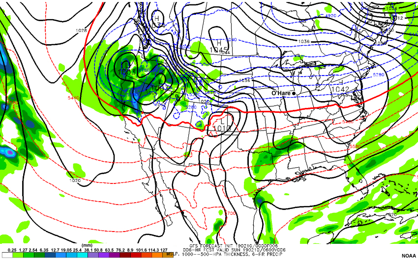
A loop of the GFS model forecast of mean sea level pressure (hPa), 1000-500 hPa thickness (meters), and 6-hour precipitation (millimeters), initialized 00 UTC February 10 2019 with forecast hours every 6 hours through 00 UTC February 14 2019.
File Name:
gfs_0210_00run.htm
Credits:
NOAA
Copyright Terms:
COMET Standard Terms of Use
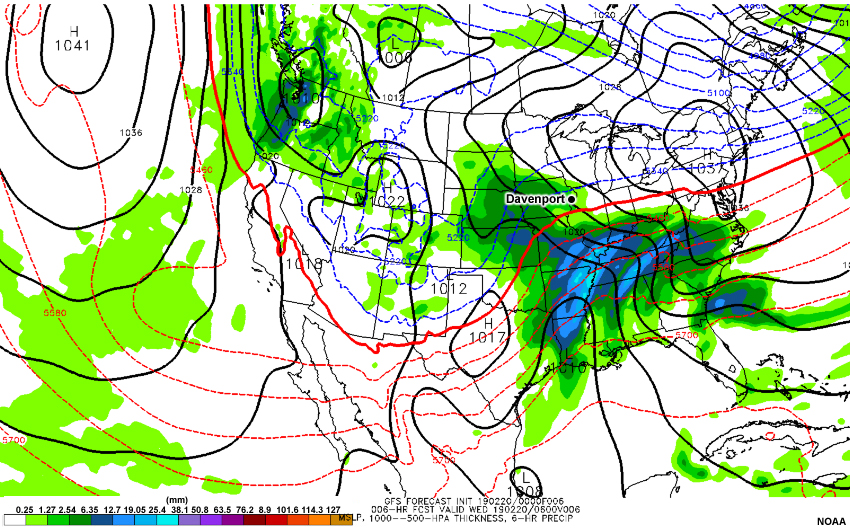
Description:
A loop of the GFS model forecast of mean sea level pressure (hPa), 1000-500 hPa thickness (meters), and 6-hour precipitation (millimeters), initialized 00 UTC February 20 2019 with forecast hours every 6 hours through 00 UTC February 25 2019.
File Name:
gfs_0220_00run.htm
Credits:
NOAA
Copyright Terms:
COMET Standard Terms of Use
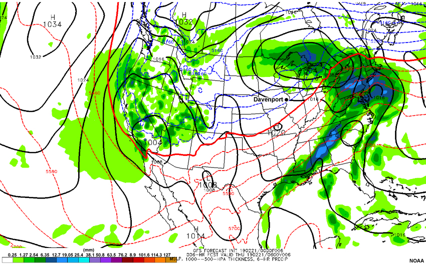
Description:
A loop of the GFS model forecast of mean sea level pressure (hPa), 1000-500 hPa thickness (meters), and 6-hour precipitation (millimeters), initialized 00 UTC February 21 2019 with forecast hours every 6 hours through 00 UTC February 25 2019.
File Name:
gfs_0221_00run.htm
Credits:
NOAA
Copyright Terms:
COMET Standard Terms of Use
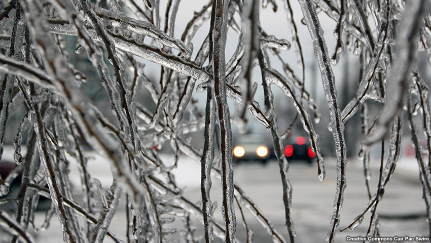
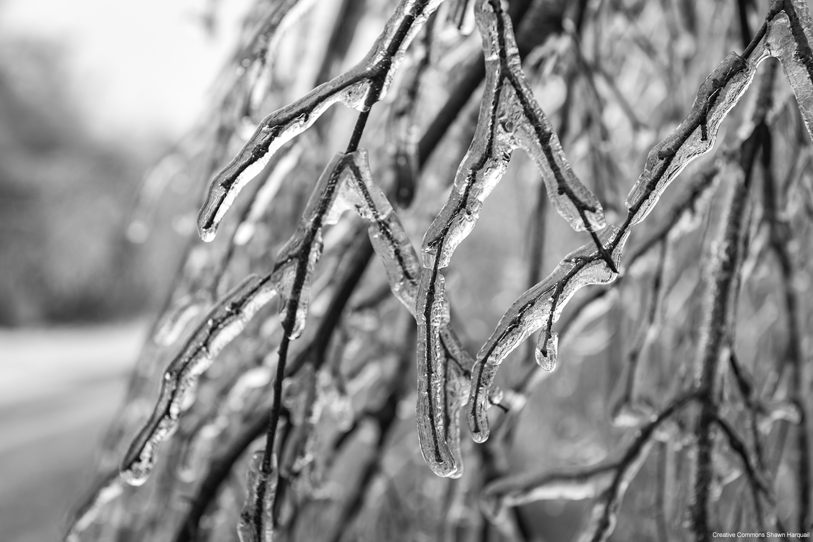
Description:
A picture of precipitation frozen on tree branches.
File Name:
icy_coating.jpg
Credits:
Creative Commons Can Pac Swire
Copyright Terms:
Creative Commons Attribution-Noncommercial 2.0 Generic
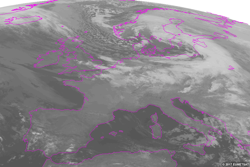
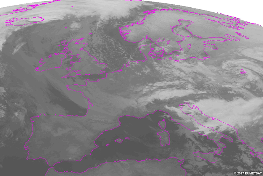
Description:
IR satellite loop from 00-12 UTC on January 4, 2017.
File Name:
IR_Satellite_20170104_0000-1200UTC.htm
Credits:
©2017 EUMETSAT
Copyright Terms:
COMET Standard Terms of Use
Description:
IR satellite loop from 00-12 UTC on January 5, 2017.
File Name:
IR_Satellite_20170105_0000-1200UTC.htm
Credits:
©2017 EUMETSAT
Copyright Terms:
COMET Standard Terms of Use
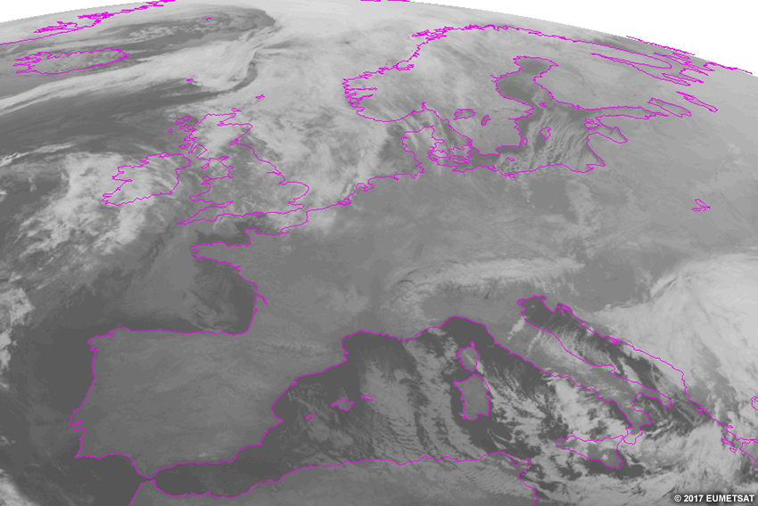
Description:
IR satellite loop from 00-12 UTC on January 6, 2017.
File Name:
IR_Satellite_20170106_0000-1200UTC.htm
Credits:
©2017 EUMETSAT
Copyright Terms:
COMET Standard Terms of Use
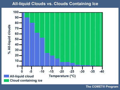
Description:
The percentage of all-liquid clouds and clouds containing ice based on cloud top temperature (Celsius).
File Name:
liq_ice_cld.jpg
Credits:
The COMET (R) Program
Copyright Terms:
COMET Standard Terms of Use
Description:
A picture of precipitation frozen on tree branches.
File Name:
module-cover.jpg
Credits:
Creative Commons Shawn Harquail
Copyright Terms:
Creative Commons Attribution-Noncommercial 2.0 Generic
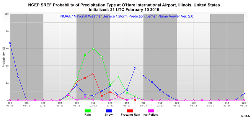
Description:
NCEP SREF plume for precipitation type at O'Hare International Airport, Illinois initialized 21 UTC on February 10, 2019. Members displayed include Probability of Precipitation in the form of rain (POPR), snow (POPS), freezing rain (POPZ), and ice (POPI).
File Name:
plume_190210_21utc.jpg
Credits:
NOAA
Copyright Terms:
COMET Standard Terms of Use
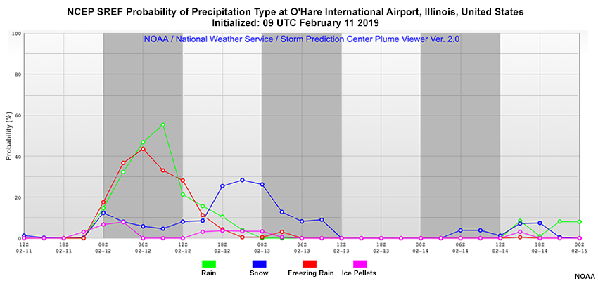
Description:
NCEP SREF plume for precipitation type at O'Hare International Airport, Illinois initialized 09 UTC on February 11, 2019. Members displayed include Probability of Precipitation in the form of rain (POPR), snow (POPS), freezing rain (POPZ), and ice pellets (POPI).
File Name:
plume_190211_09utc.jpg
Credits:
NOAA
Copyright Terms:
COMET Standard Terms of Use
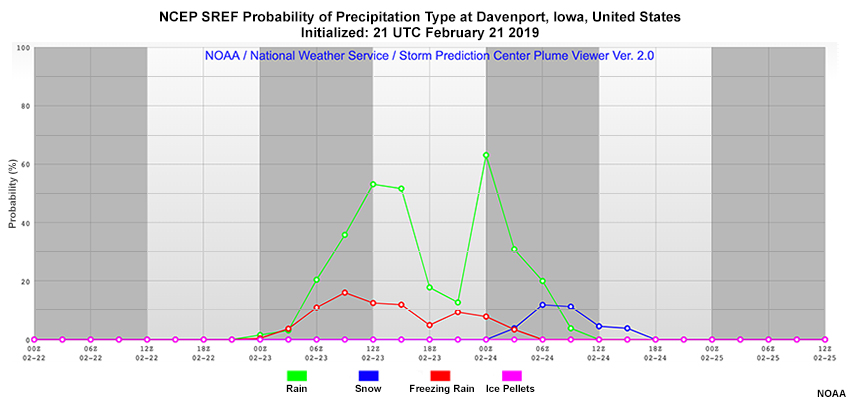
Description:
NCEP SREF plume for probability of precipitation type at Davenport, IA initialized 21 UTC on February 21, 2019. Members displayed include Probability of Precipitation in the form of rain (POPR), snow (POPS), freezing rain (POPZ), and ice pellets (POPI).
File Name:
plume_190221_21utc.jpg
Credits:
NOAA
Copyright Terms:
COMET Standard Terms of Use
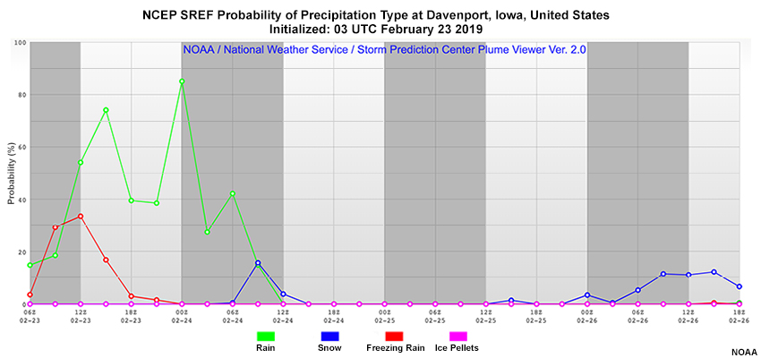
Description:
NCEP SREF plume for precipitation type at Davenport, IA initialized 03 UTC on February 23, 2019. Members displayed include Probability of Precipitation in the form of rain (POPR), snow (POPS), freezing rain (POPZ), and ice (POPI).
File Name:
plume_190223_03utc.jpg
Credits:
NOAA
Copyright Terms:
COMET Standard Terms of Use
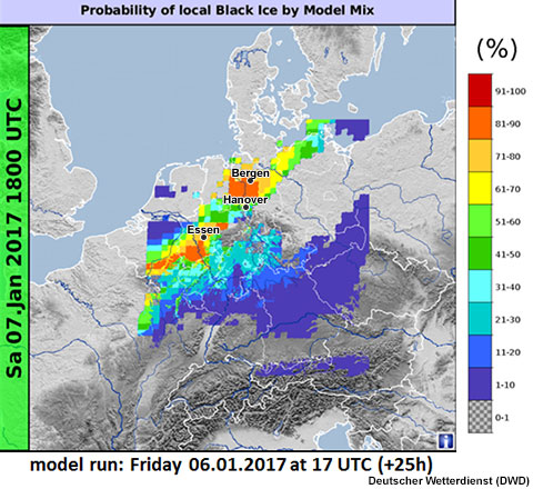
Description:
The Model Mix probability of local black ice, initialized 17Z on 6 January, valid 18Z on 7 January.
File Name:
ProbBlackIce_060117_17UTC_25h.jpg
Credits:
Deutscher Wetterdienst (DWD)
Copyright Terms:
COMET Standard Terms of Use
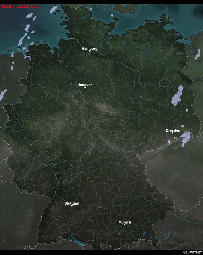
Description:
Radar reflectivity composite loop from 1815 UTC on January 6 to 1815 UTC on January 8, 2017.
File Name:
radar_17010618-17010818.mp4
Credits:
©EUMETNET
Copyright Terms:
COMET Standard Terms of Use
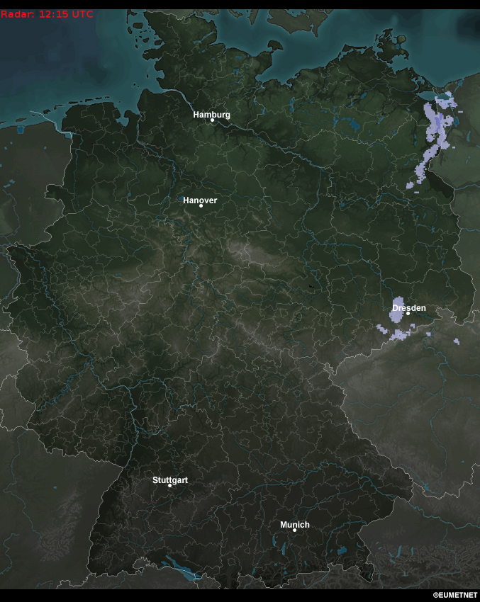
Description:
Radar reflectivity composite loop from 1215 UTC to 2015 UTC on January 6, 2017.
File Name:
radar_20170106_12-20Z.htm
Credits:
©EUMETNET
Copyright Terms:
COMET Standard Terms of Use
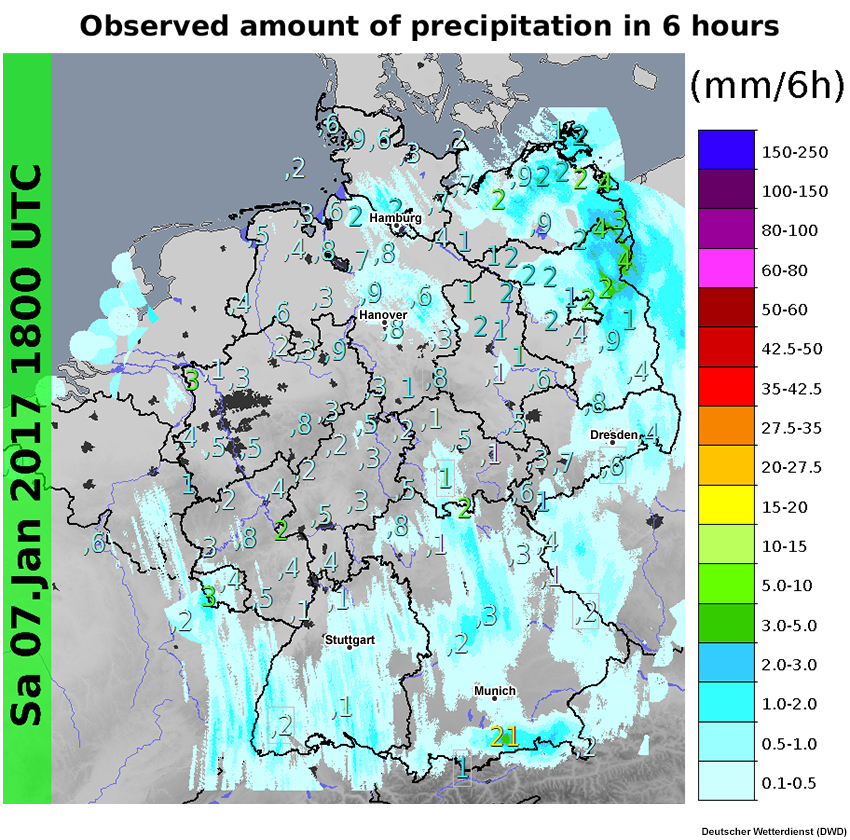
Description:
Observed precipitation (mm) between 12Z and 18Z on 7 January.
File Name:
RR6h_Obs+Radar070117_18UTC.jpg
Credits:
Deutscher Wetterdienst (DWD)
Copyright Terms:
COMET Standard Terms of Use
Description:
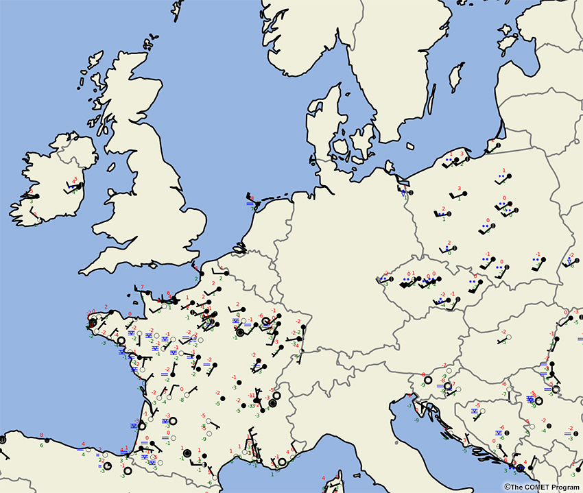
A loop of surface observations over Europe from 00-12 UTC on January 4, 2017.
File Name:
Sfc_Obs_Europe_20170104_0000-1200UTC.htm
Credits:
©The COMET Program
Copyright Terms:
COMET Standard Terms of Use
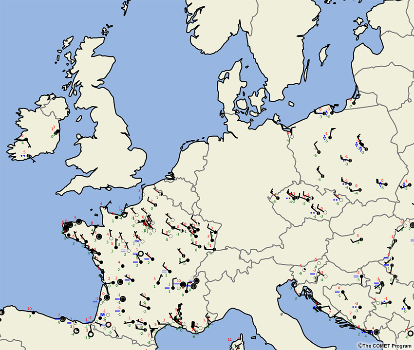
Description:
A loop of surface observations over Europe from 00-12 UTC on January 5, 2017.
File Name:
Sfc_Obs_Europe_20170105_0000-1200UTC.htm
Credits:
©The COMET Program
Copyright Terms:
COMET Standard Terms of Use
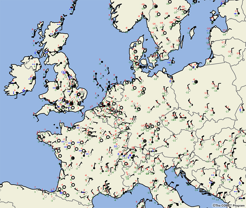
Description:
Surface observations over Europe loop from 00-12 UTC January 6, 2017.
File Name:
Sfc_Obs_Europe_20170106_0000-1200UTC.htm
Credits:
©The COMET Program
Copyright Terms:
COMET Standard Terms of Use
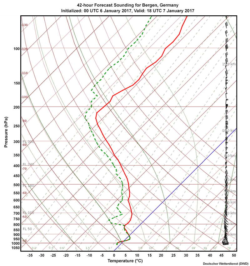
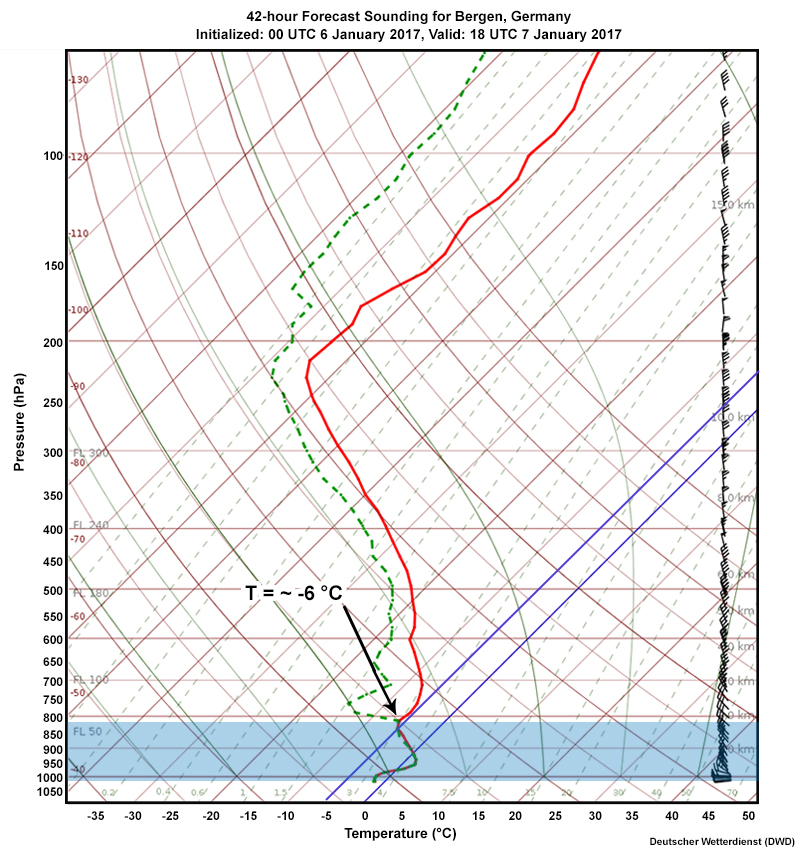
Description:
ICON-EU global model 42-hour forecast sounding for Bergen, Germany, initialized 00 UTC on January 6, valid 18 UTC on January 7, 2017.
File Name:
TempICON-EU_Bergen060117_00UTC+42h.jpg
Credits:
Deutscher Wetterdienst (DWD)
Copyright Terms:
COMET Standard Terms of Use
Description:
ICON-EU global model 42-hour forecast sounding for Bergen, Germany, initialized 00 UTC on January 6, valid 18 UTC on January 7, 2017.
File Name:
TempICON-EU_Bergen060117_00UTC+42h_feedback.jpg
Credits:
Deutscher Wetterdienst (DWD)
Copyright Terms:
COMET Standard Terms of Use
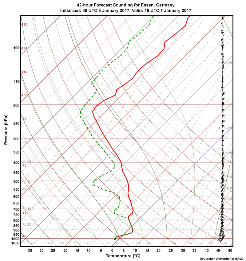
Description:
ICON-EU global model 42-hour forecast sounding for Essen, Germany, initialized 00 UTC on January 6, valid 18 UTC on January 7, 2017.
File Name:
TempICON-EU_Essen060117_00UTC+42h.jpg
Credits:
Deutscher Wetterdienst (DWD)
Copyright Terms:
COMET Standard Terms of Use
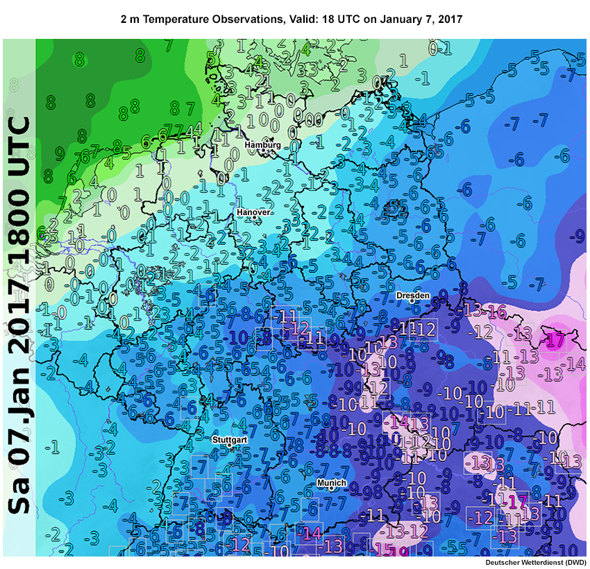
Description:
Observed 2 m temperature across Germany valid at 18Z on 7 January.
File Name:
TT2m_070117_18UTC.jpg
Credits:
Deutscher Wetterdienst (DWD)
Copyright Terms:
COMET Standard Terms of Use
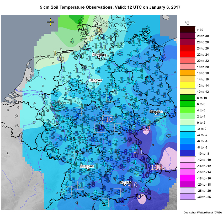
Description:
Observed 5 cm soil temperatures across Germany valid at 12Z on January 6.
File Name:
TT5cm_070117_12UTC.jpg
Credits:
Deutscher Wetterdienst (DWD)
Copyright Terms:
COMET Standard Terms of Use
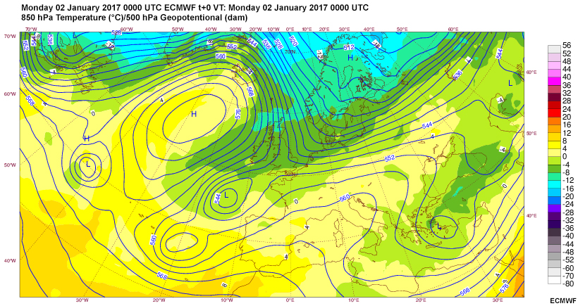
Description:
A loop of 850 hPa temperature and 500 hPa geopotential heights valid at 0000 UTC from January 2 through January 4, 2017.
File Name:
upper_air.htm
Credits:
ECMWF
Copyright Terms:
COMET Standard Terms of Use