1. Introduction
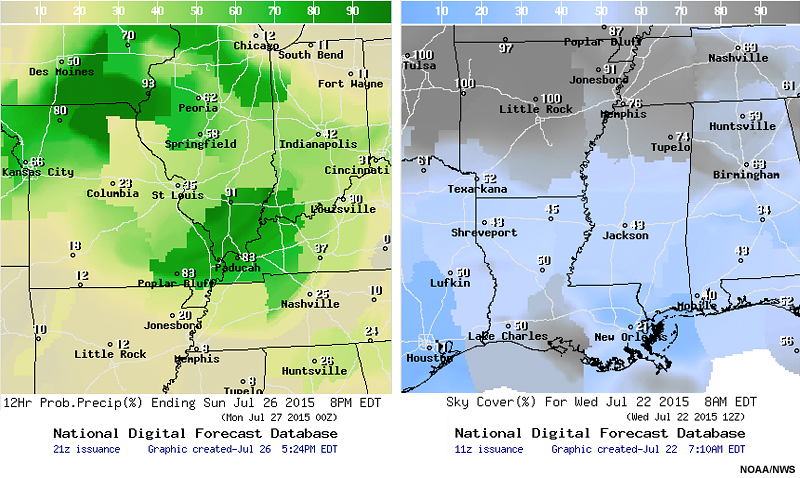
Regional examples of National Digital Forecast Database (NDFD) 12-hour probability of precipitation forecast issued on 26 July 2015 and sky cover forecast issued on 22 July 2015.
Question
How much time do you think forecasters on a shift currently spend updating the grids for the National Digital Forecast Database (NDFD)?
Feedback: The time spent will vary by office and weather scenario, but forecasters will sometimes spend up to 4 hours refining the NDFD grids.
Question
How often do the NDFD values for an area differ visually from the grids of neighboring offices?
Feedback: Qualitative views of the NDFD products suggests that inconsistencies in forecasts based on office county warning areas or political boundaries occur frequently, despite attempts by offices to have overall consistency with neighboring jurisdictions.
Question
Looking at the maps above, do you observe any inconsistencies in the forecast values based on forecast office areas of responsibility?
The National Blend of global Models (NBM) has been developed as a scientifically sound method with reduced errors and biases to provide a common starting point for a National Weather Service forecast. National Weather Service (NWS) Director Dr. Louis Uccellini provides some background on the NBM project:

Dr. Louis Uccellini, NWS Director (2015)
NWS Director Dr. Louis Uccellini talks about the inception of the National Blend of global Models.
“This effort started in the field. So my first encounter with the blend was with the Central Region and specifically the Sullivan forecast office. ... There was a number of issues that were being addressed here, and what I heard directly from the folks out in the field, as the blend gained popularity. First of all there is this consistency aspect trying to blend across the boundaries of the WFOs themselves so that we would not be building in these political boundaries into the NDFD grid sets. This as it turned out was an important complaint that was being levied against the weather service at large. … We then built this into the roadmap with the idea that we would provide a national basis for the blend, not just the individual efforts across the weather service. There were several reasons for that. I believe that from a scientific point of view, I believe this very strongly, I have said this in the past, you really need to start large and then work into the local areas. This is what synoptic and mesoscale meteorology has always been about and rather than trying to build up this national map from cobbling together 122 different WFO analyses. So it did provide a stronger basis moving forward in that regard.”