Media elements used in this module are protected by a variety of copyright licenses. Please use the "copyright terms" link associated with each item below for more information.
Description:
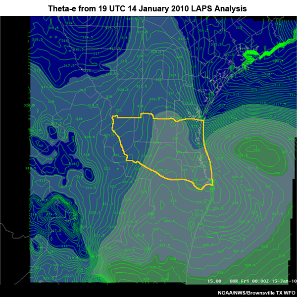
Equivalent Potential Temperature Theta-e from 00 UTC 15 January 2010 LAPS analysis over the Brownsville TX CWA. Values are shaded as per the color bar at the top of the graphic.
File Name:
01_14_LAPS_thetae.jpg
Credits:
NOAA/NWS/Brownsville TX WFO
Copyright Terms:
COMET Standard Terms of Use
Description:
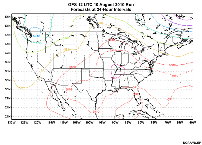
00 to 96 hour GFS 500-hPa height forecasts at 24 hour intervals from the GFS run of 12 UTC 10 August 2010. Heights in meters; contoured at 60-m intervals.
File Name:
500z_2010081012_01.htm
Credits:
NOAA/NCEP
Copyright Terms:
COMET Standard Terms of Use
Description:
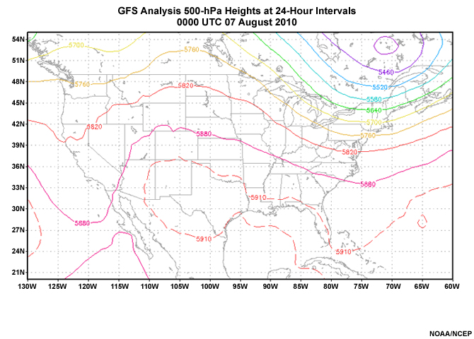
GFS 500-hPa height analyses at 24 hour intervals for the period 00 UTC 7 August 2010 through 00 UTC 10 August 2010. Heights in meters; contoured at 60-m intervals.
File Name:
500zanl_20100807_10_01.htm
Credits:
NOAA/NCEP
Copyright Terms:
COMET Standard Terms of Use
Description:
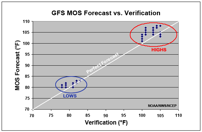
GFS MOS 2-m maximum and minimum 2-m temperature verification for all forecast cycles, 5-9 August 2010. Temperatures in degrees Fahrenheit. Perfect forecasts are on the white diagonal. High and low temperature verification clusters are annotated.
File Name:
DFWMOS_v_VERIF.jpg
Credits:
NOAA/NWS/NCEP
Copyright Terms:
COMET Standard Terms of Use
Description:
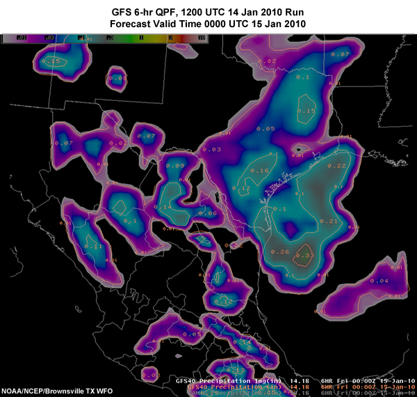
Six-hour accumulated precipitation forecast from 18 UTC 14 January 2010 GFS valid 00 UTC 15 January 2010. Shading indicates amounts in inches, per the color bar at the top of the graphic.
File Name:
GFS_18z_valid_00z_Jan15.jpg
Credits:
NOAA/NCEP/Brownsville TX WFO
Copyright Terms:
COMET Standard Terms of Use
Description:
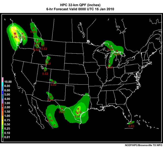
Quantitative Precipitation Forecast from the Hydrological Prediction Center for 6 hour period ending 00 UTC 15 January 2010. Values are shaded as per the color bar at the bottom left of the graphic.
File Name:
HPC_QPF_12hr.jpg
Credits:
NCEP/HPC/Brownsville TX WFO
Copyright Terms:
COMET Standard Terms of Use
Description:
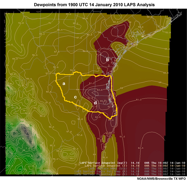
Dewpoints from 19 UTC 14 January 2010 LAPS analysis over the Brownsville TX CWA. Values are shaded as per the color bar at the top of the graphic.
File Name:
HVY_R7.jpg
Credits:
NOAA/NWS/Brownsville TX WFO
Copyright Terms:
COMET Standard Terms of Use

Description:
Picture of Jeral Estupinan, SOO from Brownsville TX and SME for this module.
File Name:
jeral.png
Credits:
©The COMET Program
Copyright Terms:
COMET Standard Terms of Use
Description:
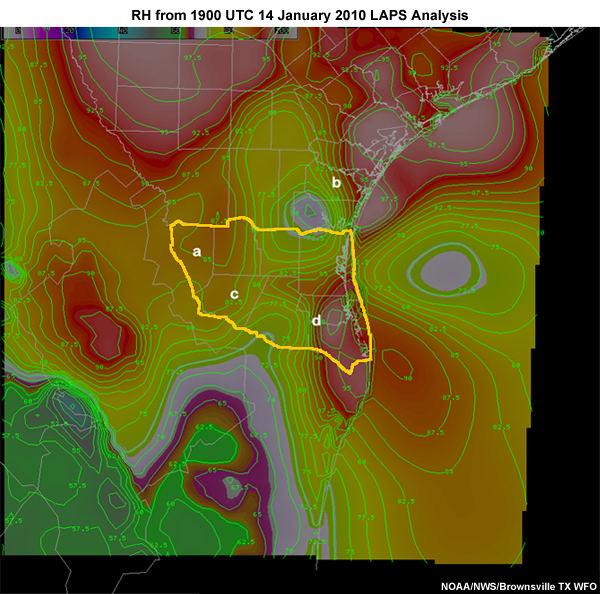
Relative humidity from 19 UTC 14 January 2010 LAPS analysis over the Brownsville TX CWA. Values are shaded as per the color bar at the top of the graphic.
File Name:
Laps_RH_grad.jpg
Credits:
NOAA/NWS/Brownsville TX WFO
Copyright Terms:
COMET Standard Terms of Use
Description:
New NWP Course icon for steps in the forecast process. The icon indicates what step(s) will be covered in the module in which it appears. This icon indicates all of the steps will be covered.
File Name:
NWPicon_all.jpg
Credits:
©The COMET Program
Copyright Terms:
COMET Standard Terms of Use
Description:
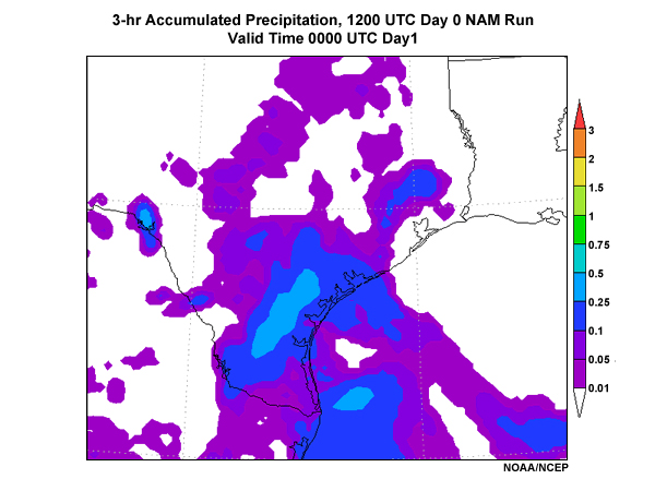
3-hour accumulated precipitation for NAM WRF/NMM model run 12 UTC day zero of case, valid time 00 UTC of day one. Precipitation amounts shaded in inches.
File Name:
p03_d0cyc12_f12.jpg
Credits:
NOAA/NCEP
Copyright Terms:
COMET Standard Terms of Use
Description:
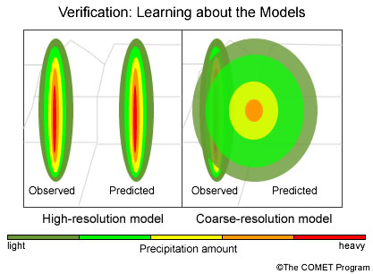
The image shows a narrow heavy band predicted perfectly except shifted by 50 km, there is no overlap between the observed and predicted rain areas. Comparing the forecast and observed point values indicates a terrible forecast. Instead, if the verification method assesses the rain area characteristics, it would indicate an excellent forecast, albeit with a position error. In contrast, a coarse-resolution model may predict too broad an area for the rain band, correctly predicting some rain in the areas where it was observed as well as predicting rain in adjacent areas where it was not observed. While the coarse-resolution forecast poorly predicted the observed structure, it would score better in a point-by-point verification method because it correctly predicted rain in some areas.
File Name:
precipverif.jpg
Credits:
©The COMET Program
Copyright Terms:
COMET Standard Terms of Use

Description:
File Name:
quiz10tabs.htm
Credits:
various
Copyright Terms:
COMET Standard Terms of Use


Description:
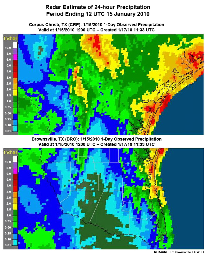
Radar estimate of precipitation for the 24 hours ending 12 UTC 15 January 2010 in the Corpus Christi and Brownsville, TX county warning areas. Areas along the coast in both county warning areas received up to 3 inches of rain.
File Name:
Radar_est_jan_15_all.jpg
Credits:
NOAA/NCEP/Brownsville TX WFO
Copyright Terms:
COMET Standard Terms of Use
Description:
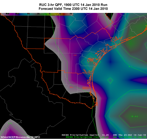
3-hour accumulated precipitation forecast from 19 UTC 14 January 2010 RUC valid 00 UTC 15 January 2010. Shading indicates amounts in inches, per the color bar at the top of the graphic.
File Name:
RUC_23z_Jan14.jpg
Credits:
NOAA/NCEP/Brownsville TX WFO
Copyright Terms:
COMET Standard Terms of Use
Description:
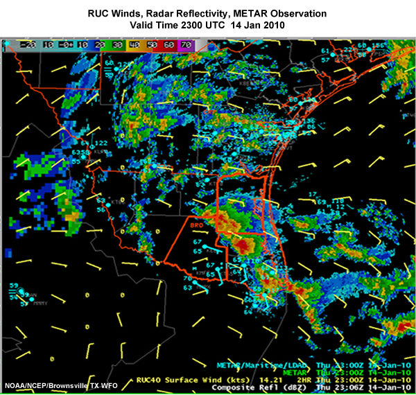
Radar reflectivity with RUC winds and METARs superimposed from 23 UTC 14 January 2010. Note line of convection starting from near Brownsville TX northwestward into the central Brownsville county warning area (CWA). RUC forecast winds show less convergence than the observations via METARs show.
File Name:
RUC_winds.jpg
Credits:
NOAA/NCEP/Brownsville TX WFO
Copyright Terms:
COMET Standard Terms of Use
Description:
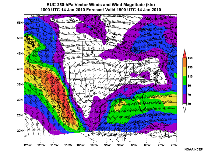
Rapid Update Cycle (RUC) forecast of 250-hPa vector winds and wind magnitude from run on 18 UTC 14 January 2010 valid at 19 UTC 14 January 2010.
File Name:
ruc2010011418f01.jpg
Credits:
NOAA/NCEP
Copyright Terms:
COMET Standard Terms of Use
Description:
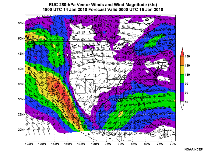
Rapid Update Cycle (RUC) forecast of 250-hPa vector winds and wind magnitude from run on 18 UTC 14 January 2010 valid at 00 UTC 15 January 2010.
File Name:
ruc2010011418f06.jpg
Credits:
NOAA/NCEP
Copyright Terms:
COMET Standard Terms of Use
Description:
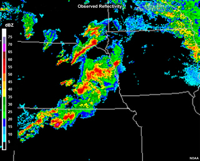
The graphic shows the corresponding observed radar reflectivity mosaic. Originally from the Effective Use of High-Resolution Models module, the lower right panel
File Name:
whichisreal_1.jpg
Credits:
NOAA
Copyright Terms:
COMET Standard Terms of Use