5.1.1 Overview
Forecasting of polar lows consists of at least five steps:
- Recognizing conditions conducive to development and, where possible, using satellite imagery to confirm the
existence of the pre-formation conditions
- Using models, synoptic charts, and experience to identify trigger mechanisms and assess how intense the system
may become
- Using all available real-time information to assess when development has commenced
- Forecasting the motion of the actual polar low or vortex
- Forecasting the dissipation of the polar low or vortex
5.1.2 Identifying Predevelopment Conditions
Although the actual polar low is sub-synoptic, the systems that produce conditions favourable for polar low
development are synoptic-scale.
Predevelopment conditions to watch for are:
 Areas where cold
air is flowing over a water surface
Areas where cold
air is flowing over a water surface
Large air/water
temperature difference
Cyclonic curvature
or contours at the 700- and 500-hPa levels
The formation of
low-level cloud streets
Surface winds of
15 knots or less
Formation of
low-level vortices. These can be individual vortices or may occur in families along a shear line or low-level
baroclinic zone
Within the cold
air mass there may be evidence of low-level baroclinic zones. These can be induced by:
Converging flows with
different over-water trajectories
Wrap-around warm air
from a synoptic low
Cold air flowing
parallel to the water-ice or water-land edge
* Note: Not all of these conditions need to be present.
Numerical guidance is invaluable for long-range forecasting of these initial synoptic conditions. Actual surface
analyses and satellite imagery are used to confirm the existence of the initial conditions.
5.1.3 Predevelopment Synoptics: Hudson Bay and Eastern Canada

For Hudson Bay and eastern Canadian waters, the initial northwesterly flow of cold arctic air is frequently the
result of a major synoptic cyclone moving offshore from Labrador or crossing the Maritimes and Newfoundland on an
east-to-northeast course that carries it south of Greenland.
Major fall and winter cyclones are often accompanied by a shift in the winter polar vortex to a location over
Foxe Basin, central or southern Baffin Island, Hudson Bay, or northern Quebec. Low-level cold arctic air then
streams from the continent and/or ice pack (depending on the time of year) over the warmer waters of Hudson Bay or
Davis Strait and the Labrador Sea. Hudson Bay has been included here although the storm tracks could be
northeastward across Quebec with the polar vortex northwest of Hudson Bay. The end result is often an air mass
with surface temperatures as lows as -20 to -35°C flowing over a water surface.
5.1.4 Predevelopment Synoptics: Gulf of Alaska
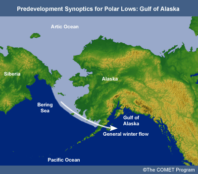
Over the Gulf of Alaska the cold air will more often than not originate over the Arctic Ocean, Eastern Siberia,
or Alaska and be pulled southward behind major synoptic cyclones moving onto the west coast or into the
southeastern portions of the Gulf of Alaska. Businger (1987) shows that an upper vortex or major upper trough is
generally positioned so that there are strengthening negative height anomalies over Alaska and the Gulf of Alaska
some two to three days prior to polar low development.
5.1.5 Predevelopment Synoptics: North Atlantic
For polar lows to form in the eastern Atlantic and northern European waters, any of a number of synoptic
situations may be present. In all cases, the lows develop within an arctic or polar air mass with the polar front
situated south of the location.
In a cold air outbreak from the arctic ice sheet, convection is initially hindered by a strong surface
inversion, often more than 5000 ft in depth. Therefore, the weather close to the ice edge is dominated by rather
homogenous shallow convection, with low-level phenomena such as convergence lines, boundary-layer fronts, and
minor troughs forming further downstream. Deep convection and polar lows start to form as the air reaches areas
with sea surface temperatures of more than 2°C. Polar lows are thus mainly found in the areas east of the
0° meridian, west of 40° east, and south of 75° north, with some cases in the area southwest of
Spitsbergen.
The west coast of Novaya Zemlya and the ice edge from the southern tip of Spitsbergen to Bear Island form
stationary baroclinic zones during the winter season, and are important sources of baroclinic instability. In
particular, the most western baroclinic zone probably influences polar low formation. Polar lows are rare east of
40 degrees east, mainly because of the low sea surface temperatures, but some cases have been recorded off the
southwestern tip of Novaya Zemlya. The areas further to the north are no less weather exposed, as old decaying
synoptic lows have a tendency to regenerate under the influence of the Novaya Zemlya baroclinic zone. This area is
also prone to strong katabatic outflows in easterly winds, generating lee troughs over open water (Heinemann
2003). Lee lows off the southeast coast of Greenland can also provide the initial surface disturbance.
Alternatively, the baroclinic zone, which is the surface trigger, may be a trough or the remnants of a
synoptic-scale system. Although many polar low outbreaks occur in a true arctic (northerly) airstream, this should
not be treated as the only likely scenario. In some rare cases, the polar low has lasted long enough in northerly
flows to reach the southern parts of the North Sea. More commonly, North Sea polar lows form in cold air outbreaks
from the Scandinavian mainland, affecting the areas mainly in the western part of the North Sea.
5.1.6 Identifying Trigger Mechanisms
Upper-level triggering mechanisms to watch for are:
Development and or
movement of an upper-level negative height anomaly. For the Bering Sea and Gulf of Alaska the Naval Tactical
Applications Guide suggests a 200 m anomaly
Approach of a 500
hPa trough or vortex with temperatures below -30°C. This is a minimum value and most of the literature
cites a sea surface-to-500 hPa difference of > 40°C
Approach of a
comma cloud, jet streak, or area of positive vorticity advection
Numerical guidance can be used to identify larger-scale triggering features. Satellite imagery can confirm and
supplement the numerical guidance by identifying cloud patterns.
5.1.7 Identifying Formation of Polar Lows
Surface reports and satellite imagery are the main tools the forecaster has at her/his disposal.
Items to look for include:
Rapid or
unexpected pressure falls in an otherwise benign environment
Rapid or
unexpected increase in surface winds
Increased snow
shower activity and possibly thundershowers at shore, island, or ship locations
Satellite imagery
showing enhanced and organized convective cloud development:
Development of
a symmetrical, spiral-shaped cloud formation
A clear eye may
be visible during the mature stage
To reach Arctic
hurricane status requires increased low-level convergence or upper-level divergence resulting in the cloud
pattern becoming asymmetrical and an anticyclonically curved cirrus shield reflecting the outflow region
(Naval Tactical Applications Guide 1992)
5.1.8 Forecasting the Motion of Polar Lows
Some of the tools and or techniques available for forecasting the motion of polar lows:
Extrapolation:
- The experience of the Norwegians is that this method is only useful for a few hours
Using a steering
flow:
- The Norwegian Polar Lows Project reported that polar lows often follow the 850- to 700-hPa wind field.
Midtbø, (1986) tested the method for the Norwegian and Barents sea area using the 850-hPa
model-predicted wind and found an average error for an 18-hour forecast of 200 km compared with a mean
path length of 800 km
- The Naval Tactical Applications Guide (1992) suggests that even strong polar lows will likely have a
representative steering level closer to 850 hPa, and that for well-developed polar lows a speed of 30
knots is not unusual
- Polar lows have been observed to travel at between 1/3 and 1/2 of the wind speed at the steering level
- Where the steering-level winds are very light or variable, the low is often more influenced by the
movement of the upper vortex
- As applicable, consider the possibility of binary rotation
Numerical models
- Improved resolution makes it more likely that the model may show a trough or vorticity maximum
associated with the surface development. Midtbø (1986) suggested following troughs and vorticity
maximums on the charts. He found the prognoses to be better in stronger pressure fields. Due to better
models this technique has more validity today
- Comparing computed tracks to past motions for consistency
Climatology
- Although detailed studies have not been conducted, there appears to be a tendency for Davis Strait
polar lows to follow the ice edge when the steering flow is light
5.1.9 Forecasting the Dissipation of Polar Lows
Although cold air vortices can persist for several days, the time that polar low criteria are met is often very
short. By their nature cold air vortices and polar lows dissipate once they move over a land or ice surface.
Vortices and polar lows also weaken and dissipate if they merge with frontal systems. Since they normally form
deep in the cold air mass, this is not likely to occur until after the systems have already started to weaken.
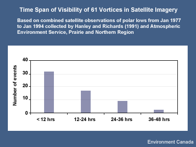
Based on observations collected by Hanley and Richards (1991) and Atmospheric Environment Service, Prairie and
Northern Region, 61 polar low and cold air vortices were examined for their time span of visibility in satellite
imagery. Although this was not the point of their study, and these statistics cannot be taken as being 100% valid,
they do point out that the tendency is for short-lived systems. It is also observed that many of the systems in
the Gulf of Alaska gradually expanded into large spiral cloud forms that then drifted southeastward as they
continued to dissipate.
References
Businger, Steven, 1987: The synoptic climatology of polar low outbreaks over the Gulf of Alaska and the Bering
Sea. Tellus, 39A, 307-325.
Hanley, D. and W.G. Richards, 1991: Polar Lows in Atlantic Canadian Waters 1977 - 1989. Report: MAES 2-91.
Scientific Services Division, Atlantic Region, Atmospheric Environment Service.
Midtbø, K.H., 1986: Polar low forecasting. Proc. Third International Conference on Polar Lows,
Norway.
Naval Tactical Applications Guide. Vol. 8. Part 2, Arctic. East Siberian/Chukchi/Beaufort Seas. NRL/PU/7541
92-0005.
Parker, Neil, 1997: Cold Air Vortices and Polar Low Handbook for Canadian Meteorologists. Environment
Canada.