2.3.1 Norwegian Coastal Waters
Information on occurrences of polar lows from all areas of European waters is scarce. By far the most
comprehensive studies have been made concerning the Norwegian coastal region. A recently concluded study by Noer
et al. (2003) broadly agrees with the trends found from an earlier one by Lystad (1986).
Only 49 cases were
recorded in the four seasons 1999-2003, whereas the previous study found 79 cases in
the three years 1982-1985 (Lystad 1986). The reduced frequency in the later study is a result of more restricted
criteria for defining a polar low and the use of improved satellite data for verification. Many of the cases that
now are classified as common troughs were classified as polar lows in the earlier study.
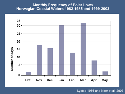
The graph shows the frequency of polar lows for each of the winter months based on the combined results of the two studies. The maximum frequency of polar lows was found to occur in January and March, with a secondary maximum in November. The minimum in February is probably due to a high occurrence of continental high pressure over central Scandinavia giving a southerly flow along the Norwegian coast. There is also large annual variation in the data from season to season. In the months of February to May 2003 the observed number of polar low events was low, which can be explained by the presence of long spells of southerly winds.
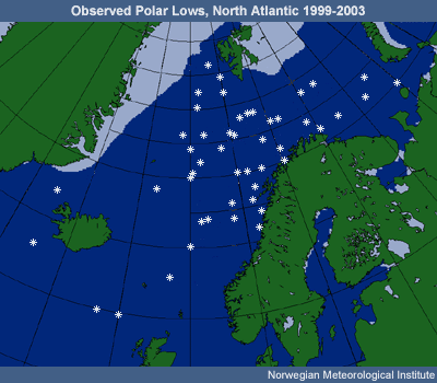
Although the statistical basis is thin, in the 49 cases recorded since 1999 there is a slight tendency to a monthly shift westward as the season progresses, this being consistent with the variability of the sea surface temperatures. The cases east of 40 deg. were all in October to January, while the April and May cases were all west of 10 deg.
Noer's study also noted that during the seasons 1999-2003 a polar low was found to develop in 27% of the cases where both a low-level cold outbreak and an upper cold trough were present, but no detailed examination of the upper trough was carried out before the prediction was made.