2.2.1 Pacific Climatology

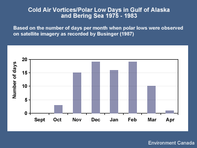
A primary area of polar low development in the Pacific is the northern portion of the Gulf of Alaska. Businger
(1987) recorded the geographic locations of spiral cloud signatures associated with polar lows in this region for
the period 1975-1983. He found that once conditions favourable for polar low development are established, they
often persist for several days, resulting in the formation of more than one polar low.
Closer observation of these statistics suggests that many of the vortices that develop in the Gulf of Alaska tend
to drift southeastward, remaining off the mainland coast as they dissipate.
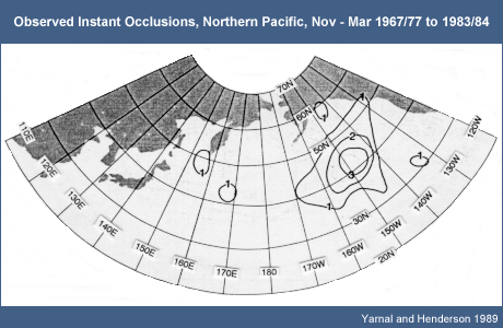
Yarnal and Henderson (1989) interpreted satellite imagery for seven five-month seasons between November and
March, 1976/77-1983/84. They subjectively classified observed polar lows into two categories: comma cloud and
spiral form. They then evaluated how many evolved to a higher stage of development.
Their results:
- Only six comma-cloud polar lows were detected in their database, of which three evolved to a high stage.
Perhaps more noteworthy is the fact that relative to the western Pacific, few comma-cloud polar lows were
observed over the eastern Pacific.
- The maximum number of spiral-form polar lows was observed in the northern Gulf of Alaska. But in the sample
studied, none progressed beyond this form. For the forecaster this implies that at least with respect to the
Gulf of Alaska, once a spiral-form polar low has formed, the risk of further development is minimal.
2.2.2 Pacific Climatology: Instant Occlusions
Instant occlusions are also significant events to consider. Mullen (1983) identified these as potential
initiators of explosive cyclogenesis. Yarnal and Henderson (1989) state that "... although the eastern North
Pacific is an area of low polar low frequency, the potential for explosive cyclogenesis is much greater in this
part of the basin because of the concentration of instant occlusions. Thus, the entire extratropical west coast of
North America is exposed to the dangers of these storms." Note that the reference here is to the eastern
Pacific, and not the Gulf of Alaska where polar lows are more likely to be observed.
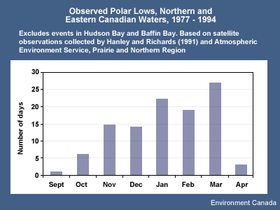
2.2.3 Northern and Eastern Canadian Waters
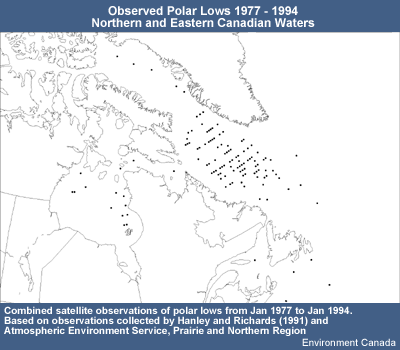
Studies tracking the occurrences of polar lows across northern and eastern Canadian waters show a high
concentration of events in the southern Davis Strait and Labrador Sea (Hanley et al. 1991). Events also occur, but
with less frequency, in the Hudson Bay and off the southern coast of the Maritimes.
The frequency of events increases between November and March, with a drop-off in April.
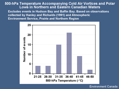
Based on the observations collected by Hanley and Richard (1991), only two events occurred with the 500-hPa
temperatures between -21 and -25°C. When the 500-hPa temperature falls below -30°C, the number of polar
lows observed increases significantly.
Based on this analysis, once the temperatures fall below -30°C, the forecaster should start looking more
closely for signs of surface development if other conditions are favourable.
References
Broadfoot, D. 1990: 12 December 1989. Lake Superior polar low, unpublished presentation.
Businger, Steven, 1987: The synoptic climatology of polar low outbreaks over the Gulf of Alaska and the Bering
Sea. Tellus, 39A, 307-325.
Carleton, Andrew, 1985: Satellite climatological aspect of the "polar low" and "instant
occlusion". Tellus, 37A, 433-450.
Hanley, D. and W.G. Richards, 1991: Polar Lows in Atlantic Canadian Waters 1977 - 1989. Report: MAES 2-91.
Scientific Services Division, Atlantic Region, Atmospheric Environment Service.
Parker, Neil, 1997: Cold Air Vortices and Polar Low Handbook for Canadian Meteorologists. Environment
Canada
Yarnal, B. and Henderson, G., 1989: A satellite-derived climatology of polar-low evolution in the North
Pacific. Int. J. Climatology, 9, 551-566.