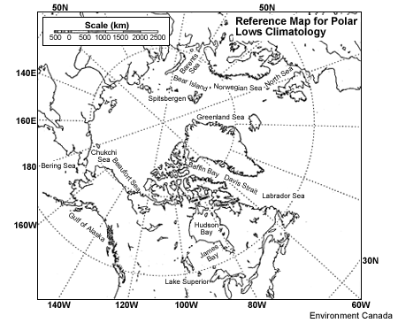
2.1.1 Reference Map
Cold air vortices and polar lows occur in areas where cold air has an opportunity to flow over a water surface.
Additionally, polar lows are most often associated with an upper-level cold core low or cold upper trough. This
map shows areas susceptible to these conditions during parts of the year.
2.1.2 Seasonal Variations in Genesis Areas
(click to view animation in seperate browser window - 516 kb)
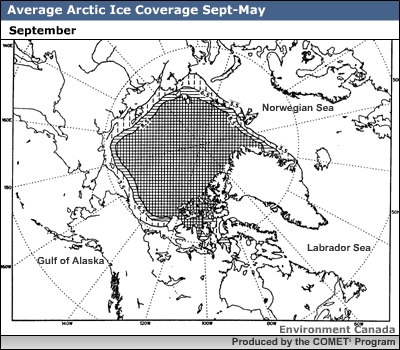
Ice cover charts can be used to gain an insight on the geographic and seasonal variation of areas favourable for
polar low development.
September represents the period of minimum ice cover. However, the availability of cold air places this month at
the shoulder of the fall polar low season. It is the time of maximum open water in the Beaufort and Chukchi Seas
as well as in Baffin Bay.
By early October the risk of polar low development in the Beaufort Sea is all but over, and by late December the
risk of development in Hudson Bay and Baffin Bay has also passed. The southeastern portions of the Hudson Strait
remain ice free most years. Ice cover eventually extends southward along the Labrador Coast to Newfoundland but
the major portion of the Labrador Sea remains open and is a prime polar low development area.
The Gulf of Alaska also remains open year round and is a prime development area. Additionally, the occurrence of
comma clouds is higher in the North Pacific than over Northern Atlantic waters (Carleton, 1985), which adds
another dimension for the forecaster to consider.
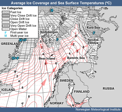
The maximum extent of sea ice cover east of Greenland is limited to the northernmost areas of the region. To the
east of Spitsbergen, the ice often stretches down to Bear Island, but this varies during the season according to
the weather. In the easternmost part of the North Atlantic basin, the Kara Sea east of Novaya Zemlya is
ice-covered from November on, but the Barents sea west of Novaya Zemlya stays ice free most of the winter. These
areas together with the central Arctic ice sheet form the main sources of cold low-level air during the winter
season.
The sea surface temperature in this region is strongly influenced by the Gulf current, which occupies the
southern part of the Norwegian and the Barents sea. The Gulf current divides into two branches. One moves east
along the north Norwegian coast, but weakens as it approaches Novaya Zemlya. The other branch moves north into the
waters west of Spitsbergen. This makes for a steadily rising temperature from the ice edge in the north to the
Norwegian coast in the south, giving prime conditions for convective activity to form in a northerly flow.
References
Carleton, Andrew, 1985: Satellite climatological aspect of the "polar low" and "instant
occlusion". Tellus, 37A, 433-450.
Parker, Neil, 1997: Cold Air Vortices and Polar Low Handbook for Canadian Meteorologists. Environment
Canada