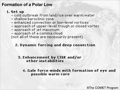
1.3.2 Formation of the Mature Polar Low
Once the precursors have been identified, the challenge is to forecast the likely timing and position of a polar
low. Where the low-level disturbance and upper-level forcing are forecast to coincide, this may be considered the
most likely position for rapid development. Thus, an estimate of the position and timing of polar low formation
may be made.
The transformation from a vortex to a polar low is usually very rapid. This is the result of both the dynamic
forcing associated with the upper system and the initiation of deep convection resulting from decreased mid- and
high-level stability. It is at this time that CISK (conditional instability of the second kind) and/or air-sea
interaction instability may begin contributing to the deepening process. Surface winds will rapidly increase to
gale force or stronger, thus meeting the adopted criterion for a true polar low. At times an eye will be visible
on satellite imagery. Studies have shown that a warm core often forms (Rasmussen 1985, Shapiro et al. 1987).
On occasion, a polar low may develop hurricane force winds. This degree of deepening requires strong low-level
convergence and or upper-level divergence. The resulting cloud pattern will become asymmetrical with an
anticyclonically curved cirrus shield reflecting the outflow region (Fett et al. 1993).
Sidebar: Fett et al. (1993) reported on the passage of a polar low over St. Paul Island that
produced a three-hour pressure drop of 13 hPA and a three-hour pressure rise of 13 hPa as it passed over the
station. At the same time the temperature rose and fell 4°C.
1.3.3 Weather and Sea State in a Mature Polar Low
By the time a polar low reaches a mature state, heavy snow showers and blowing snow will have developed and
surface visibilities will frequently be reduced to near zero. Rapid changes in wind direction may occur due to the
small size of the system. Lightning may be observed. Heavy in-cloud aircraft icing may also occur.
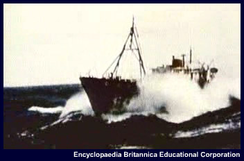
The small size of the polar low and the strong curvature might lead one to reach the conclusion that significant
wave development would be fetch-limited. This is not always the case and presents additional risk to offshore
activity. Fett et al. (1993) states that a St. Paul Island polar low produced 60-knot winds and 9-meter waves as
measured by a Soviet icebreaker.
Intense circulations, such as tropical cyclones and polar lows, have the potential to develop large ocean waves.
Usually in the case of a tropical cyclone, the larger, quicker-moving waves escape beyond the generation area,
propagating ahead of the storm as decaying swell waves. However, as a tropical cyclone move to higher latitudes,
the circulation is more likely to move at a velocity close to the group speed of the waves within the storm. In
particular, waves to the right of the storm track usually propagate in the direction of the storm's motion,
thereby allowing for prolonged forcing by the wind. The fetch becomes trapped within the storm as it moves along.
Under ideal conditions, the significant wave height generated within the trapped fetch can grow to over twice the
height of a wave associated with a stationary storm.
On the right side of the storm in relation to its movement, the winds will be at their strongest, while to the
left the wind direction will oppose both the system itself and the broad-scale flow. For example, along the
Norwegian coast the presence of a polar low close to the coast can induce offshore (easterly) winds to the north
of its center. This has the effect of replacing an unstable, showery flow with clearer, more stable conditions.
1.3.4 Motion of Polar Lows
Because polar lows generally develop well behind synoptic systems, they are likely to have a moderate steering
flow above them and thus may move faster than the initiating low (which may have slowed down or stalled). Speeds
of 20 to 30 knots are not uncommon.
Because of their shallow nature, the steering flow will often be found at a lower level than that normally
associated with synoptic systems. Businger and Reed (1989) suggest using the 850-700 hPa wind field. In the case
of reverse shear lows, the steering flow may be quite light. A rule of thumb suggests that the actual speed of
propagation is often 1/3 to 1/2 of the wind speed at the steering level (Noer et al. 2003).
Renfrew et al. (1996) examined three cases of multiple polar lows occurring in the Bear Island area. They noted
that binary interaction between pairs of polar lows can cause a cyclonic co-rotation of the two lows when the lows
were in the same vicinity.
Binary rotation is probably not surprising to many operational meteorologists who have observed upper-level
vortices rotate, especially at northern latitudes.
1.3.5 Dissipation of Polar Lows
Polar lows making landfall or moving over an ice surface will rapidly weaken as their source of energy is cut
off. If they stay over water, they may persist for several days. However, they are more likely to pass through the
mature stage and begin to degrade into a larger convective vortex within a short time period.
Cold air vortices may also become involved with fronts or synoptic systems. Since they normally form deep within
the cold air mass, this is more apt to be the fate of a dissipating vortex rather than a mature polar low.
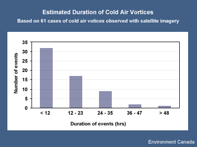
A database compiled by Hanley and Richards (1991) was examined to determine the length of time vortices were
followed on satellite imagery, keeping in mind that a number of factors may have resulted in the termination of
the satellite archive for a particular vortex. The results show that the majority of cases were followed for less
than 24 hours. This indicates, but does not confirm, a short duration for the systems observed in their study.
References
Bader, M.J., G.S. Forbes, J.R. Grant, R.B.E. Lilley, and A.J. Waters, 1995: Images in Weather Forecasting.
Cambridge University Press.
Businger, S. and R. Reed, 1989: Cyclogenesis in cold air masses. Wea. Forecasting,
4. No 2., 133-156.
Dysthe, K.B. and A. Harbitz, 1987: Big waves from polar lows? Tellus, 39A, 500-508.
Fett, R.W., R.E. Englebretson, and D.C. Perryman, 1993: Forecasters Handbook for the Bering Sea, Aleutian
Islands, and Gulf of Alaska. U.S. Naval Research Laboratory. NRL/PU/7541-93-0006.
Hanley, D. and W.G. Richards, 1991: Polar Lows in Atlantic Canadian Waters 1977-1989. Report: MAES 2-91.
Scientific Services Division, Atlantic Region, Atmospheric Environment Service.
Noer, G. and M. Ovhed, 2003: Forecasting of polar lows in the Norwegian and the Barents Sea. Proc. Ninth
meeting of the EGS Polar Lows Working Group, Cambridge, UK.
Parker, Neil, 1997: Cold Air Vortices and Polar Low Handbook for Canadian Meteorologists. Environment
Canada
Rasmussen, Erik A., 1985: A case study of a polar low development over the Barents Sea. Tellus,
37A, 407-418.
Rasmussen, Erik A. and Anette Cederskov, 1994: Polar lows: A critical analysis. The life cycles of extratropical
cyclones. Vol. 111. Proc. of an International Symposium, Bergan, Norway.
Renfrew, Ian, G.W.K. Moore, and Aashish A. Clerk, 1996: Binary interactions between polar lows. Submission to
Tellus, 22 November 1996; also Extended Abstract, Workshop on Theoretical and Observational Studies of
Polar Lows, St. Petersburg, Russian Federation, 23-26 September 1996.
Shapiro, M.A., L.S. Fedor, and Tamara Hampel, 1987: Research aircraft measurements of a polar low over the
Norwegian Sea. Tellus, 39A, 272-306.
Wilhelmsen, K., 1985: Climatological study of gale-producing polar lows near Norway. Tellus, 37A,
451-459.