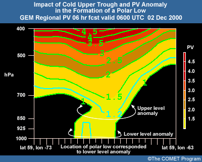
Topics in Winter Weather Forecasting
Polar Low Forecasting
1 Disturbances in Cold Air Masses
As a cold air mass moves over a water surface, there is a transfer of sensible heat from the water to the air; this decreases the low-level stability of the air mass. The cold air mass has a low wet-bulb potential temperature, and there is a rapid transfer of moisture into the colder air as it modifies through the input of sensible heat. Clouds usually form soon after the air begins its over-water trajectory, signifying the release of latent heat. This deep, concentrated convection is frequently associated with polar low development.
This figure is a plot of potential temperature against height through the boundary layer of a cold air mass moving over a warmer water surface.
In a uniform flow, such as shown in this satellite image, there is little development other than a change in the structure of the cumulus cells. Mullen (1983) refers to Ellenton (1980) and Bosart (1981), who point out that surface heating is not directly responsible for cyclogenesis; instead it serves to establish a favourable low-level environment that likely facilitates development in response to later external forcing mechanisms
Baroclinic instability is associated with vertical shear of the mean flow. Baroclinic instabilities grow by converting potential energy associated with the mean horizontal temperature gradient (Holton 1992).
Enhanced low-level baroclinic zones can develop due to various conditions.
The early view of polar lows was that they were the result of thermal instability. That changed when Harrold and Browning (1969) used radar to investigate a December 1967 polar low that crossed southwestern England. They found that much of the precipitation formed within uniformly ascending air, not by the merging of smaller-scale convective cells. In their study, the convection was confined to the rear of the system.
Rasmussen et al. (1994) state that polar low development as the result of purely baroclinic or convective process is rare. However, Rasmussen and Aakjær (1989) reported on two polar lows that affected Denmark and appeared to be baroclinic throughout their existence. One formed near the main frontal zone while the second formed in association with a cold vortex, which was the end product of an occlusion. In the earlier paper they state that such events are fairly common in the North Sea region.
Barotropic instability is a wave instability associated with the horizontal shear in a jet-like current. Barotropic instabilities grow by extracting kinetic energy from the mean flow field (Holton 1992).
Barotropic instability can result in the formation of low-level shear vortices. Given further upper support, these vortices may then develop into polar lows. Rasmussen et al. (1994 and 1996) identify this as the likely development mechanism for the polar lows they studied in the Labrador Sea.
If a low-level baroclinic wave, barotropic shear vortices, or areas of enhanced convection have formed in a cold air mass, when will further development occur, if at all?
Rasmussen (1992) states, "In the case of a straight upper-level flow with little or small vorticity advection, polar lows will not develop even in cases when the upper-level temperatures are very low.” With this in mind we must look for forcing mechanisms. One obvious mechanism at northern latitudes is the cold upper trough and/or closed, cold-core upper vortex.
Rasmussen (1996) states that all of the polar lows he has investigated in the Labrador Sea were initiated by a cold upper trough or vortex. Furthermore, all of the cases investigated by Parker and Hudson (1991) and Parker (1992) involved a cold trough and/or closed vortex at the 500hPa level. In the Pacific, a comma cloud often accompanies the upper trough and can aid in early detection of a forcing mechanism.
A study by Noer et al. (2003) on the formation of polar lows in the Norwegian Sea area shows that in all cases a cold upper trough or vortex was associated with the low development. Indeed, it can often be shown that the movement and strength of this upper forcing can give good guidance on the subsequent evolution and motion of the system.
The similarity between some polar lows and tropical hurricanes has caused a number of researchers to speculate that like processes might be involved. Conditional instability of the second kind, or CISK, is one such process.
Charney and Eliassen (1964) defined CISK as a cooperative interaction between small-scale cumulus convection and a larger-scale disturbance where:
CISK then implies a positive feedback mechanism at work in the system.
A number of researchers have in the past suggested that CISK is a driving force for polar lows. The feeling now appears to be that CISK may contribute to the development of polar lows, but is not the sole driving force.
Emanuel (1986) opposed the idea of CISK for tropical cyclones. He proposed that tropical cyclones result from air-sea interaction instability. Anomalous sea-surface fluxes of sensible and latent heat induced by strong surface winds and falling pressure lead to increased temperature anomalies and thereby to further increases in surface winds and pressure deficit.
Emanuel and Rotunno (1989) tested Emanuel's air-sea interaction theory for polar lows. Their case study used a simple non-linear analytical model and an axisymmetric numerical model. Results showed that the air-sea interaction hypothesis is consistent with observed arctic low development, but requires a pre-existing disturbance to act as a triggering mechanism before the air-sea interaction instability can operate.
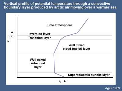
Agee, Ernest M. and Steven R. Gilbert, 1989: An aircraft investigation of mesoscale convection over Lake Michigan during the 10 January 1984 cold air outbreak. J. Atmos. Sci., 46, No.13, 1877–1897.
Bader, M.J., G.S. Forbes, J.R. Grant, R.B.E. Lilley, and A.J. Waters, 1995: Images in Weather Forecasting. Cambridge University Press.
Charney, J. and A. Eliassen, 1964: On the growth of the hurricane depression. J. Atmos. Sci., 21, 68-75.
Emanuel, Kerry, A., 1986: A two stage air sea interaction theory for polar lows. Proc., The Third International Conference on Polar Lows, Norway.
Emanuel, Kerry A. and Richard Rotunno, 1989: Polar lows as arctic hurricanes. Tellus, 41A, 1-17.
Noer, G. and M. Ovhed, 2003: Forecasting of polar lows in the Norwegian and the Barents Sea. Proc. of the 9th meeting of the EGS Polar Lows Working Group, Cambridge, UK.
Harrold, T.W. and K.A. Browning, 1969: The polar low as a baroclinic disturbance. Quart. J. Roy. Meteor. Soc., 95, 710-723.
Holton, James, R., 1992: Introduction to Dynamic Meteorology. 3d ed. Academic Press Ltd., London, U.K..
Mullen, S., 1983: Explosive cyclogenesis associated with cyclones in polar air streams. Mon. Wea. Rev., 111, 1537-1553.
Parker, M.N. and Edward Hudson, 1991: Polar Low Handbook for Canadian Meteorologists. Environment Canada, Atmospheric Environment Service.
Parker, Neil, 1997: Cold Air Vortices and Polar Low Handbook for Canadian Meteorlogists. Environment Canada.
Parker, M.N, 1992: Polar lows in the Beaufort Sea and Davis Strait. Proc. Applications of New Forms of Satellite Data in Polar Low Research, Polar Low Workshop, Hvanneyri, Iceland.
Rasmussen, Erik A. and P.D. Aakjær, 1989: Two polar lows affecting Denmark. Vejret, Special Issue in English, The Danish Meteorological Society.
Rasmussen, Erik A., John Turner, and Paul Twitchell, 1992: Applications of new forms of satellite data in polar low research. Bull. Amer. Meteor. Soc., 74, 1057-1073.
Rasmussen, Erik A. and Anette Cederskov, 1994: Polar lows: A critical analysis. The life cycles of extratropical cyclones. Vol 111. Proc. of an International Symposium, Bergan, Norway.
Rasmussen, Erik A., Chantal Claud, and James F. Purdom, 1996: Labrador Sea polar lows. The Global Atmosphere and Ocean System, Vol. 4, 275-333.
Shapiro, M.A., T. Hampel, and L.S. Fedor, 1989: Research aircraft observations of an arctic front over the Barents Seas. Polar and Arctic Lows, Polar and Arctic Lows. Twitchell, P., E. Rasmussen, K. Davidson, Eds., A. Deepak Publishing.