Case Profile
Overview
This case begins while starting a shift at 0300 UTC on 01 Dec 2000 in the Arctic Forecasting Centre in Edmonton, Canada. Familiarize yourself with the setting for this case by reviewing the Case Profile.
|
Location of Interest |
Hudson and Ungava Bay Region, Northern Canada 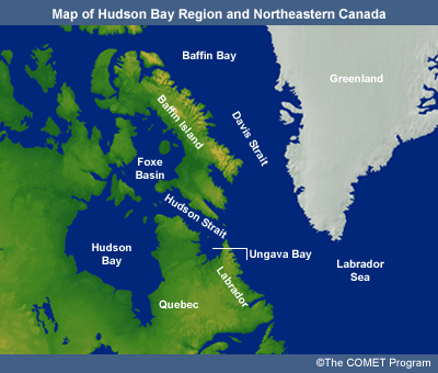
|
|
Case Time Frame |
0000 UTC 01 Dec 2000-0000 UTC 03 Dec 2000 |
|
Phenomena of Interest |
Polar Lows |
|
Forecasting Challenges |
|
Case Profile
Introduction to the case setting with a synoptic overview.
Case Challenge
A series of forecasting questions accompanied by a rich set of of data and background
content to challenge forecasting skills.
Case Summary
An expert's overview of the case as it unfolded.
Resources
Bibliography and links to more information on Polar Lows.
Surface Analysis
Current Time: 0300 UTC 01 Dec 2000
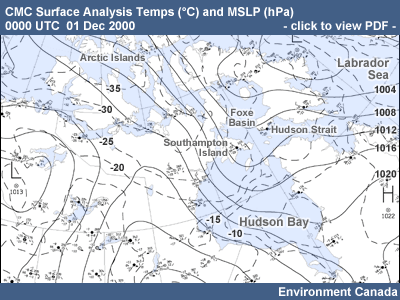
It is 0300 UTC 01 Dec 2000. 0000 UTC data are available, and the new prog set has started to arrive. You are familiarizing yourself with the synoptic situation over northeastern Canada. There are only a few 0000 UTC surface observations (manned and automatic) as the smaller sites closed down for the evening at 2300 UTC.
At the surface, a low remains quasi-stationary in Baffin Bay. The low-level flow over much of northern Canada from Hudson Bay eastwards is westerly to northwesterly around this low. Surface temperatures in the source region of this flow, the Arctic Islands and across Keewatin and into northwestern Hudson Bay, are very cold, in the range of -30°C.
Click the image to view a large-format .pdf version of the CMC Surface Analysis.
500-hPa Heights and Temps
Current Time: 0300 UTC 01 Dec 2000
The 500-hPa 00-hr prog shows a low over Foxe Basin with a trough extending southwestward through western Hudson Bay. Temperatures in the trough are –39°C or colder. A well defined vorticity center is situated south of Southampton Island. These features have been moving eastward during the last 12 hours, and this motion is expected to continue. A second trough extends from the Foxe Basin low southeastwards over Baffin Island and into the Labrador Sea.
Use the check box selections to view the various fields from the GEM Regional 00-hr forecast. Or, click here to view a large-format .pdf version of the four-panel GEM Regional Charts for 0000 UTC.
Ice Analysis Chart
Current Time: 0300 UTC 01 Dec 2000
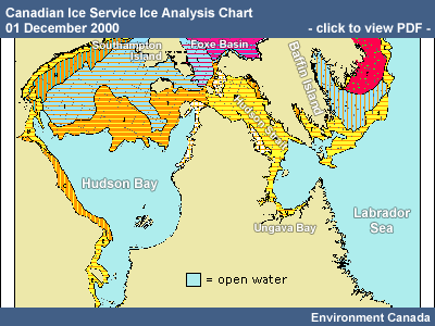
It is early December and you know that there will still be open water in many parts of the North. The current ice analysis from the Canadian Ice Service is hanging on the wall. It shows that southern and southeastern Hudson Bay still have open waters. Open water is also found in Ungava Bay, eastern Hudson Strait, and over most of the Labrador Sea.
Click the image to view the full-size ice analysis for the
Hudson Bay region. For detailed information on how to interpret
the ice charts, please see the Canadian
Ice Service website.
(https://www.canada.ca/en/environment-climate-change/services/ice-forecasts-observations/latest-conditions.html)
NOAA-14 IR
Current Time: 0300 UTC 01 Dec 2000
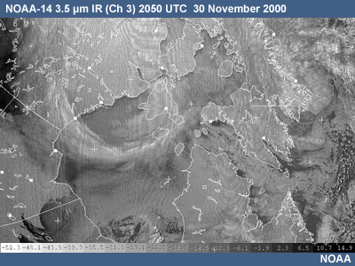
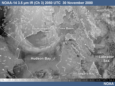
As it is after 0000 UTC, there won’t be any POES imagery over this area until around 0800 UTC. However, you have one recent picture from 2050 UTC 30 Nov of a POES NOAA-14 IR. It shows a band of cirrus and altostratus aligned with the upper trough through Hudson Bay, and the head of a comma cloud associated with the vorticity center over Southampton Island. In some locations, surface wind directions can be inferred through the low-level streamers that have formed with the passage of cold air over open water or leads. One such example in the image is the westerly winds over western Hudson Strait.
For more information on interpreting multispectral satellite imagery, see Feature Identification Exercises: Clouds, Snow, and Ice Using MODIS. (https://www.meted.ucar.edu/npoess/modis_exercises/)
Case Challenge
Overview
From the perspective of a forecaster, respond to this series of forecast questions. The questions go through the process of identifying predevelopment, formation, and evolution of a polar low. Each question entails the use of observations, model analysis, and model prognoses. Use the Data links to pop open a new browser window displaying the data. Use the links to the Supportnig Topics for access to background information.
Use the Data links to pop open a new browser window displaying the data.
Use the links to the
Supporting Topics for access to background information.
Question 1
Current Time: 0300 UTC 01 Dec 2000
Question
Examine the GEM regional NWP guidance (00, 12, 24, 36 and 48-hour forecasts) initialized at 0000 UTC 01 Dec. Identify any mid-level features in the area of Hudson Bay, Foxe Basin, Hudson Strait, Ungava Bay, and the Labrador Sea that might contribute to the development of a polar low during the next 36 hours. Choose all that apply:
Model Data: | GEM Regional |
Observations: | AVHRR |
Analysis: | Canadian Ice Service (interpretation reference) | Surface |
The correct answers are a, b and e.
General Considerations
While looking for upper-level support, be on the lookout for the following
conditions:
- Cyclonic curvature or contours at the 700- and 500-hPa levels
- Development and/or movement of an upper-level negative height anomaly
- Approach of a 500-hPa trough or vortex with temperatures below -30°C. This is a minimum value and most of the literature cites values 5 to 10 degrees colder
- Approach of a comma cloud, jet streak, or area of positive vorticity
advection
Cold
upper trough moving eastward from northern Hudson Bay
The development of a polar low is generally associated with very cold air in
the midlevels that leads to an unstable air mass as it passes over open water.
A threshold value often used is a temperature of less than -40°C at 500
hPa, but forecasters should follow the situation closely if temperatures are
-30°C or colder. Values of -40°C or colder are present in the trough
initially over Foxe Basin and most of Hudson Bay. These temperatures are
maintained
in the trough as it moves eastward.
500-hPa
vorticity centre moving eastward from northern Hudson Bay
Even with favourable low-level conditions, a trigger mechanism is still required
to initiate a polar low. One candidate for this is the region of upward vertical
motion associated with the PVA ahead of the vorticity maximum, initially near
Southhampton Island. The guidance indicates that both the cold temperatures
in the trough and the strength of the associated vorticity pattern are
maintained
as the trough swings eastwards over the next 48 hours.
NOTE: Another way of looking at this question is through the use of the potential vorticity field. Just as PVA can be related to quasigeostrophic upward vertical velocity (QG UVV), positive potential vorticity advection (PPVA) is also related to UVV. In this case the strongest PPVA in the 280-290 K isentropic layer (500 hPa falls in this layer in this case) moves eastward from northern Hudson Bay and across far northern Quebec to the Labrador Sea by 48 hours.
Warm
advection moving across Hudson Bay in the 12-48 hr
period
While such warm advection may be related to upward vertical motion, it also
acts to stabilize the vertical profile.
Upper
cold advection in westerly/northwesterly winds just west of the cold upper
trough
This is associated with downward vertical motion.
Vertical
motion at the base of the upper trough over central and southern Hudson Bay
This area of well defined vertical motion at 700 hPa in the 12-hour forecast
has only weak QG forcing (weak thermal and vorticity advections) so it appears
to be due to other forcings. In any case, if the surface and low level
conditions are favourable, then this upward vertical motion might provide
a trigger for polar low formation, given that 500-hPa temperatures colder
than -35°C extend
into south Hudson Bay through 24 hours.
Polar Low Forecasting Topics
* = Most relevant topics for this page.
Disturbances in Cold Air Masses
- Development of Forcing Mechanisms
- Types of Disturbances
- Development of a Polar Low
Climatology of Cold Air Vortices and Polar Lows
- Reference Map and Seasonal Ice Coverage
- Regional Climatology: Pacific and Canadian Waters
- Regional Climatology: Atlantic and European Waters
Monitoring and Nowcasting of Polar Lows
- Nowcasting
- Use of Satellite Imagery
Polar Lows and NWP
- Factors Contributing to the Quality of NWP
- The Future of the Operational Environment
Forecasting Process for Polar Lows
- Five-Step Forecast Process
- Overview
- *Identifying Predevelopment Conditions
- *Predevelopment Synoptics: Hudson Bay and Eastern Canada
- Predevelopment Synoptics: Gulf of Alaska
- Predevelopment Synoptics: North Atlantic
- *Identifying Trigger Mechanisms
- Identifying Formation of Polar Lows
- Forecasting the Motion of Polar Lows
- Forecasting the Dissipation of Polar Lows
- Polar Low Forecasting Checklist
Question 2
Current Time: 0300 UTC 01 Dec 2000
Question
Which of the following regions have surface and low-level conditions that might be favourable for the development of a polar low in the next 36 hours?
Model Data: | GEM Regional |
Observations: | AVHRR |
Analysis: | Canadian Ice Service (interpretation reference) | Surface |
The correct answers are b, f and g.
General Considerations
In considering possible polar low development, ice/water or cold
land/water
boundaries are of great importance because they
result in low-level baroclinic zones. These zones are thought to augment
low-level
baroclinic instability and so be more favourable
to polar low development than open water without such boundaries.
Other surface and low-level conditions to be looking for include:
- Areas where cold air is flowing over a water surface
- Large air/water temperature difference
- Cyclonic curvature or contours at the 700- and 500-hPa levels
- The formation of low-level cloud streets
- Surface winds of 15 knots or less
- Formation of low-level vortices. These can be individual vortices or may occur in families along a shear line or low-level baroclinic zone
- Within the cold air mass there may be evidence of low-level baroclinic
zones. These can be induced by:
- Converging flows with different over-water trajectories
- Wrap-around warm air from a synoptic low
- Cold air flowing parallel to the water-ice or water-land edge
Northern
Hudson Bay, Foxe Basin, Western Hudson Strait
These areas are ice-covered, so no polar low development will occur.
Southern/southeastern
Hudson Bay
Cold low-level air is streaming into the area from the northwest and is
undergoing significant warming as it crosses the large area of open water.
With no ice/water boundary in this area, polar low develoment is unlikely.
Eastern
Hudson Strait
Although there is an ice/water boundary, the 1.5-m temperatures near
the boundary never get colder than about -10°C. The 925- and 850-hPa baroclinic
zones do not show much alignment with the ice/water boundary. The low-level
flow is not predicted to bring the available cold air directly across the
ice/water
boundary to the open water area.
Central
Hudson Bay, Ungava Bay, Labrador Sea
Not only do these areas have very cold air flowing over open water at some time
during the 0-36 hour forecast period, but they
also have some low-level baroclinic zones formed by either ice or cold land
next to open water. Furthermore, 925- and 850-hPa baroclinic zones do line up
at some point with the ice/water or land/water boundaries.
NOTE: According to the Canadian Arctic Weather Centre's Polar Low Handbook, a temperature difference of 20°C between the water temperature and the low-level air temperature is considered favourable for the initial formation of cold air vortices and polar lows, due to the massive sensible and latent heat transfer from the water to the atmosphere. Forecasters should not limit themselves strictly to this criterion, though: as a rough rule of thumb, they may wish to consider the situation carefully whenever this temperature difference is 15°C or greater.
One other point noted in the Polar Low Handbook is that the near-surface winds are often light (< 15 kts) before the formation of the polar low. Since heat transfer from the water to the lowest levels of the atmosphere is proportional to both the temperature difference and the wind speed over the open water, then with light wind speeds the required heat transfers can be attained only with large temperature differences (15°C or greater according to our simple rule of thumb) in the initial phases of polar low development. Later, when the winds are stronger, then the associated heat transfers are stronger as well, and the polar low can exist with a lower temperature difference (perhaps only a few degrees) between the water and the air. We can even speculate that the wind effect is related to the spiral arms seen in some polar lows: as the low develops and a ring of stronger winds forms around it, the increasing heat transfers from the water to the air supports more convection while convergence into the low turns the convection inward, forming spiral bands.
NOTE: It does appear, that a polar low can form and develop in the presence of winds greater than 15 kts. Indeed, one might speculate that a sort of "cold injection" of very cold air by strong winds over open water would create very favourable conditions for polar low formation and deepening, due to the paraticularly strong water-to-air heat transfers that would occur in that case.
Polar Low Forecasting Topics
* = Most relevant topics for this page.
Disturbances in Cold Air Masses
- Development of Forcing Mechanisms
- Types of Disturbances
- Development of a Polar Low
Climatology of Cold Air Vortices and Polar Lows
- Reference Map and Seasonal Ice Coverage
- Regional Climatology: Pacific and Canadian Waters
- Regional Climatology: Atlantic and European Waters
Monitoring and Nowcasting of Polar Lows
- Nowcasting
- Use of Satellite Imagery
Polar Lows and NWP
- Factors Contributing to the Quality of NWP
- The Future of the Operational Environment
Forecasting Process for Polar Lows
- Five-Step Forecast Process
- Overview
- *Identifying Predevelopment Conditions
- *Predevelopment Synoptics: Hudson Bay and Eastern Canada
- Predevelopment Synoptics: Gulf of Alaska
- Predevelopment Synoptics: North Atlantic
- *Identifying Trigger Mechanisms
- Identifying Formation of Polar Lows
- Forecasting the Motion of Polar Lows
- Forecasting the Dissipation of Polar Lows
- Polar Low Forecasting Checklist
Question 3
Current Time: 0300 UTC 01 Dec 2000
Question
Based on the current and projected mid- and low-level conditions, determine the area(s) and timing where polar low development is most likely to occur.
Model Data: | GEM Regional |
Observations: | AVHRR |
Analysis: | Canadian Ice Service (interpretation reference) | Surface |
The correct answers are shown above.
Central Hudson Bay:
An ice/water boundary exists over central Hudson Bay, and already at 0000 UTC on
01 Dec, very cold low-level air is flowing off the ice and
over the water. The 500-hPa temperature is near -40°C, and the upper flow
is somewhat cyclonic at the base of the main upper trough. Some upward vertical
motion is occurring at levels such as 850 hPa through 500 hPa. However, this
potential trigger moves rapidly southeastward, so that 12 hours later it is
found over the southeastern corner of Hudson Bay, in an area unfavourable for
polar low development. For the central area of Hudson Bay near the ice edge,
it appears that, though all the basic factors for possible polar low development
are present initially, the trigger moves out of the area too fast. The model
shows only slight strengthening of a weak surface trough moving from central
Hudson Bay to outheastern Hudson Bay in the 0-12
hour period.
Eastern Hudson Strait:
Despite the presence of an upper-level trigger in the form of some mid-level
upward vertical motion at 24 and 36 hours, the low level conditions are not
particularly favourable, as outlined in question 2.
Ungava Bay:
There is open water over the Bay with some ice along the shore. The 1.5-m
temperatures
reflect this N-S ice/water gradient. By the 24-36
hour period, the 925- and 850-hPa baroclinic zones reinforce the
near-surface
baroclinic zone over the western part of the bay. This alignment results in
a deeper baroclinic zone. Very cold air in the lowest levels streams
eastward
across the strip of ice along the western side of Ungava Bay and out over
the
open water. By the 24-hr forecast, 1.5-m temperatures are predicted to be in
the -14 to -18°C range over the open water.
With the approach of the upper trough, the Ungava Bay area is under 500-hPa PVA starting at about 24 hours. The expected QG UVV is confirmed by the model’s mid-level vertical motion field. The 500-hPa flow is cyclonic, and temperatures at that level are just below -40°C in the 24- and 36-hour forecasts. These conditions come together to suggest the possibility of a polar low in Ungava Bay late in the 12-24 hour period and with greater possibility in the 24-36 hour period.
The model MSL forecast shows an elongated weak low over Ungava Bay/eastern Hudson Strait by 24 hours, and a somewhat more defined low over Ungava Bay by 36 hours.
Labrador Sea:
The ice/water boundary just southeast of southern Baffin Island does have some
low-level air of -10°C and colder moving off the ice and over the water,
with northerly winds at 36 hours. Upper support to trigger development has not
arrived here by this time, so no polar low should form through 36 hours.
The other region of interest is just east of the northern tip of Labrador, where
at 36 hours cold air is flowing offshore and over the open water of the sea.
The 500-hPa temperature is around -40°C. The 925- and 850-hPa isotherms
are more or less lined up with the land/sea boundary. Upper support in the form
of upward vertical motion is also over the area by this time. The low-level
temperatures appear
marginal, with the model forecasting 1.5-m temperatures of -10°C and colder
in a very narrow strip just off the land area of northern Labrador. For this
reason, and since the other factors appear to have just come together, polar
low formation is unlikely here through 36 hours. However, you might want to
keep an eye on this region for the 36-48 hour period.
Polar Low Forecasting Topics
* = Most relevant topics for this page.
Disturbances in Cold Air Masses
- Development of Forcing Mechanisms
- Types of Disturbances
- Development of a Polar Low
Climatology of Cold Air Vortices and Polar Lows
- Reference Map and Seasonal Ice Coverage
- Regional Climatology: Pacific and Canadian Waters
- Regional Climatology: Atlantic and European Waters
Monitoring and Nowcasting of Polar Lows
- Nowcasting
- Use of Satellite Imagery
Polar Lows and NWP
- Factors Contributing to the Quality of NWP
- The Future of the Operational Environment
Forecasting Process for Polar Lows
- Five-Step Forecast Process
- Overview
- *Identifying Predevelopment Conditions
- *Predevelopment Synoptics: Hudson Bay and Eastern Canada
- Predevelopment Synoptics: Gulf of Alaska
- Predevelopment Synoptics: North Atlantic
- *Identifying Trigger Mechanisms
- Identifying Formation of Polar Lows
- Forecasting the Motion of Polar Lows
- Forecasting the Dissipation of Polar Lows
- Polar Low Forecasting Checklist
Question 4
Current Time: 1500 UTC 01 Dec 2000
Question
It is now near the end of the shift, 1500 UTC on 01 Dec. It appears that the 1200 UTC run of the GEM regional model will be delayed due to circumstances beyond your control. You'll have to make do with the run from 0000 UTC on 01 Dec.
As expected, satellite imagery shows no evidence of polar low development over the Hudson Bay through 1400 UTC. In terms of polar low forecasting, your attention is concentrated on the Ungava Bay area. From previous evaluation you know that the most likely time of development is late on 01 Dec through 1200 UTC on 02 Dec. For your current assessment, focus on the 36 hour time period of 1200 UTC on 01 Dec through 0000 UTC on 03 Dec.
The GEM regional guidance initialized at 0000 UTC 01 Dec carries a weak elongated MSL low over northern Ungava Bay and eastern Hudson Strait. By 1200 UTC on 02 Dec, the MSL forecast shows a somewhat more organized system with a central pressure near 1005 hPa over Ungava Bay. In the subsequent 12-hour period, this system splits, with part of it remaining nearly stationary in Ungava Bay, and the other part moving eastward across the Torngat Mountains and into the Labrador Sea.
Assess the guidance for factors related to the expected depth of the low in the Ungava Bay area:
Model Data: | GEM Regional |
Observations: | AVHRR | GOES IR
Analysis: | Canadian Ice Service (interpretation reference) | Surface |
The correct answers are c and d.
Model
too weak because it contains no linkage between the model surface and the
model atmosphere
All modern NWP models use physics packages that link surface processes with the
model atmosphere.
Model
too deep because of convective feedback effects due to the deep convection
parameterization
Convective feedback is generally associated with a strong maximum in
precipitation
in the vicinity of a low that is too deep, coupled with a strong vertical motion
maximum at mid levels above the low. Neither of these is present in this
case.
Model
too weak because of errors in its ice coverage field
The Ice Service analysis chart shows a narrow band of 9/10 or more ice coverage
along the western, southern and southeastern shores of Ungava Bay. The ice
coverage used by the model shows a broader U-shaped ice pattern with less open
water in the Bay than is really the case. This spreading out of the model ice
is probably related to the resolution of the ice analysis. The CMC ice analysis
is done on a 1/3 by 1/3 degree Gaussian grid, approximate 35-km resolution
and so likely has trouble in defining sharp ice edges such as the one observed
over Ungava Bay. In turn, the model's baroclinic zone, in its boundary layer
near its ice/water boundary, will not be sharp enough. Such a low-level
baroclinic
zone can be important in polar low development. These factors probably lead
to more support for polar low development in the real atmosphere than in the
model.
Model
too weak because of inadequate horizontal resolution
In addition to the broader band of ice in the model than in reality, the
mesoscale
aspects of both the baroclinic zones and the ensuing small-scale polar low
are difficult for the model to predict and maintain. The horizontal resolution
of the GEM regional model used in this case is 24 km. Ungava Bay is roughly
2 deg latitude, or about 220 km across. The polar low fits into the Bay, so
we might assign it a scale of 200 km. To be well-forecast in a numerical model,
a feature must be on the order of at least eight times larger than the model
horizontal grid spacing (for a review of this concept, see "A 20-km grid
depicts 40-km features" in Ten
Common NWP Misconceptions.) A 200-km feature is therefore barely into
the realm of being well-forecast with a 24-km model, and clearly the details,
such as the convective elements and the spiral arms, cannot be handled by the
model.
Another factor to consider is the resolution of the assimilation system, currently on a 0.9 deg., or roughly 100-km, grid. Clearly this is not adequate for such a polar low.
For these reasons, in this case horizontal resolution considerations may be related to a forecast low that is too weak.
Polar Low Forecasting Topics
* = Most relevant topics for this page.
Disturbances in Cold Air Masses
- Development of Forcing Mechanisms
- Types of Disturbances
- Development of a Polar Low
Climatology of Cold Air Vortices and Polar Lows
- Reference Map and Seasonal Ice Coverage
- Regional Climatology: Pacific and Canadian Waters
- Regional Climatology: Atlantic and European Waters
Monitoring and Nowcasting of Polar Lows
- Nowcasting
- Use of Satellite Imagery
Polar Lows and NWP
- Factors Contributing to the Quality of NWP
- The Future of the Operational Environment
Forecasting Process for Polar Lows
- Five-Step Forecast Process
- Overview
- Identifying Predevelopment Conditions
- Predevelopment Synoptics: Hudson Bay and Eastern Canada
- Predevelopment Synoptics: Gulf of Alaska
- Predevelopment Synoptics: North Atlantic
- Identifying Trigger Mechanisms
- Identifying Formation of Polar Lows
- Forecasting the Motion of Polar Lows
- Forecasting the Dissipation of Polar Lows
- Polar Low Forecasting Checklist
Question 5
Current Time: 0600 UTC 02 Dec 2000
Question
It is now the second day of monitoring the region. The latest model run initialized at 0000 UTC 02 Dec is available. It maintains a weak area of low pressure over Ungava Bay. Examine the latest surface analysis and available observations and imagery through 0600 UTC to verify the model's six-hour forecast. Look for conditions that could lead to a polar low developing over the Ungava Bay area.
Model Data: | GEM Regional |
Observations: | AVHRR | GOES IR | Station Observations
Analysis: | Canadian Ice Service (interpretation reference) | Surface |
The correct answers are shown above.
A ridge is building to the west of the Ungava Bay area and is strengthening the westerly flow across the Ungava Peninsula and over Ungava Bay. The GOES and AVHRR IR imagery shows mid-layer cloud crossing the western coast near 1900 UTC on 01 Dec. Behind it, the atmosphere over the open water is initially clear due to the drier air behind the trough. An increasing number of streamers can be seen extending eastward from the central west coast of Ungava Bay by 2200 UTC.
By 0515 UTC, the GOES IR imagery shows the old comma cloud rapidly spinning up and beginning to form a more distinct spiral-shape over Ungava Bay.
The surface observations from stations along the west coast of Ungava Bay show the passage of the trough near 1900 UTC by the shift in winds to westerly and the drop in dew points and temperatures. Winds over the central west coast after passage of the trough are 15-20 kts.
Rapid or unexpected pressure falls - slight
or uncertain
At station WKW, the 0500 UTC observed pressure is 1007.8
hPa and is falling. However, the GEM Regional 6-hour forecast indicates near
1009 hPa at that point.
Rapid or unexpected increase in surface winds
- slight or
uncertain
After 2200 UTC, there are only 3 stations reporting: YVP, WRH, WKW.
Up to 0600 UTC, YVP and WRH do not show any significant changes in wind.
However,
observed winds are stronger at WKW, with an interesting gust to 32 kts at 0200
UTC.
Increased snow shower activity - slight or
uncertain
This is difficult to determine as there are so few data observations
in the area. But note that observations at YVP indicate snow showers from
2000 UTC on 01 Dec ending at 0040 UTC on 02 Dec.
Satellite imagery showing enhanced, organized
convective cloud
development -
yes
Between 0000 UTC to 0300 UTC 02 Dec there is significant low-level convective
cloud development taking place over the open water of Ungava Bay. The appearance
of the clouds is less sharp than at lower latitudes due to the poor GOES
resolution
in the north.
Symmetric, spiral-shaped cloud formation -
yes
The low deepens quickly as the mid-level comma cloud moves over the open water
of Ungava Bay by 0400 UTC. Within 2 hours, the distinctive spiral-shaped
cloud formation has developed.
Polar Low Forecasting Topics
* = Most relevant topics for this page.
Disturbances in Cold Air Masses
- Development of Forcing Mechanisms
- Types of Disturbances
- Development of a Polar Low
Climatology of Cold Air Vortices and Polar Lows
- Reference Map and Seasonal Ice Coverage
- Regional Climatology: Pacific and Canadian Waters
- Regional Climatology: Atlantic and European Waters
Monitoring and Nowcasting of Polar Lows
- Nowcasting
- Use of Satellite Imagery
Polar Lows and NWP
- Factors Contributing to the Quality of NWP
- The Future of the Operational Environment
Forecasting Process for Polar Lows
- Five-Step Forecast Process
- Overview
- *Identifying Predevelopment Conditions
- Predevelopment Synoptics: Hudson Bay and Eastern Canada
- Predevelopment Synoptics: Gulf of Alaska
- Predevelopment Synoptics: North Atlantic
- Identifying Trigger Mechanisms
- Identifying Formation of Polar Lows
- *Forecasting the Motion of Polar Lows
- *Forecasting the Dissipation of Polar Lows
- Polar Low Forecasting Checklist
Question 6
Current Time:
Question
It is now the second day of monitoring the region. The latest model run initialized at 0000 UTC 02 Dec is available. It maintains a weak area of low pressure over Ungava Bay. Examine the latest surface analysis and available observations and imagery through 0600 UTC to verify the model's six-hour forecast. Look for conditions that could lead to a polar low developing over the Ungava Bay area.
Model Data: | GEM Regional |
Observations: | AVHRR | GOES IR | Station Observations
Analysis: | Canadian Ice Service (interpretation reference) | Surface |
The correct answers are shown above.
The three methods give different results. Deciding which of these is the best approach in this case is difficult. If a polar low does develop, it will be important to closely monitor its progress with satellite imagery and observations. Once the low is developed and in motion, hindsight will serve to indicate which method applies best to this case.
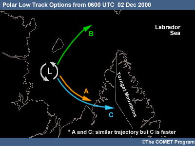
Model position of low - A
The model is about 50 km too far east with the polar low position in its
6-hour forecast valid 0600 UTC. Its curving track takes it to southeastern
Ungava Bay by 1800 UTC. The model low fills and disappears as it moves over
the peninsula.
Initialization is a key element in the model's attempts to handle polar lows. Given the sparse data in this region, the initialization may have weaknesses. As assimilation schemes improve, the model's treatment of such smaller scale systems are also improving. The judicious use of model output, with subjective corrections for initial analysis problems, is certainly a tool not to be ignored in forecasting the track of a polar low in the very short term.
Note: the model low deepening over the Labrador Sea to the east of the peninsula at this time is not the polar low; it is a separate feature.
Steering flow at 700 hPa - B
The weak steering flow indicates a slow northward motion of the polar low.
The use of a steering flow at various levels, such as 850 hPa and 700 hPa, possibly works better if the polar low is not under or very close to a sharp upper trough. In this case it is. When the low is this close to the upper trough, it is just not clear how to choose the steering flow.
Upper-level trough - C
The upper trough at 500 or 700 hPa continues to move eastward during the period.
This approach moves the low eastward across Ungava Bay, the Torngat Mountains,
and into the Labrador Sea.
This approach is more like a simple forecast rule used to forecast the motion of a developing synoptic scale low. A good part of the development of the polar low is related to surface and low-level effects, such as the transfer of latent and sensible heat from the open water to the atmosphere. The use of the upper trough motion will not account for these effects. In this case, it is not yet clear if it would give either a correct speed or direction of motion.
Polar Low Forecasting Topics
* = Most relevant topics for this page.
Disturbances in Cold Air Masses
- Development of Forcing Mechanisms
- Types of Disturbances
- Development of a Polar Low
Climatology of Cold Air Vortices and Polar Lows
- Reference Map and Seasonal Ice Coverage
- Regional Climatology: Pacific and Canadian Waters
- Regional Climatology: Atlantic and European Waters
Monitoring and Nowcasting of Polar Lows
- Nowcasting
- Use of Satellite Imagery
Polar Lows and NWP
- Factors Contributing to the Quality of NWP
- The Future of the Operational Environment
Forecasting Process for Polar Lows
- Five-Step Forecast Process
- Overview
- Identifying Predevelopment Conditions
- Predevelopment Synoptics: Hudson Bay and Eastern Canada
- Predevelopment Synoptics: Gulf of Alaska
- Predevelopment Synoptics: North Atlantic
- Identifying Trigger Mechanisms
- Identifying Formation of Polar Lows
- Forecasting the Motion of Polar Lows
- *Forecasting the Dissipation of Polar Lows
- Polar Low Forecasting Checklist
Question 7
Current Time: 1430 UTC 02 Dec 2000
Question
As suspected, the satellite imagery at this point in time shows that a polar low has fully formed and is moving across Ungava Bay. The low has the convection pattern associated with many polar lows: a spiral shape with arms composed of convective cloud elements with well-defined edges. Since it formed, right around 0600 UTC, it has been moving in the same direction as the upper-level trough.
Compare the GEM regional model initial pattern at 1200 UTC on 02 Dec to the latest surface observations and the satellite imagery at that time. Given this comparison, do you expect the guidance to correctly forecast the evolution of the low?
Model Data: | GEM Regional |
Observations: | AVHRR | GOES IR | Station Observations
Analysis: | Canadian Ice Service (interpretation reference) | Surface |
The correct answer is b.
No, don't expect the guidance to correctly forecast
the evolution of the
low.
For the initialization, the model realizes "something" is
there, but still holds onto a broad elongated low covering the open water over
Ungava Bay and extending through Hudson Strait to the Labrador Sea. The model's
behavior is the same as in previous runs. Between 0000 and 0600 UTC the low
begins to break in two, with half following the upper-level support and the
other staying in Ungava Bay and slowly decaying throughout the day.
Though the model has placed an area of low pressure in the Ungava Bay area, it is not very well resolved. As previously discussed, the diagnostics and resolution are not quite refined enough to handle a feature as small as this polar low.
One weakness of the model is in its initial depth of the low. For example, the initial model MSL pressures are approximately 1008 hPa at WKW and 1007 hPa at WRH, with the depth of the trough between the two no lower than 1005 hPa. In reality, the observed pressure at WKW is 1005 hPa, 3 hPa deeper than the model. A manual surface analysis indicates that the likely depth of the low is below 1004 hPa.
Note also that the observation at WRH shows a pressure of 1008 hPa. The gradient between WKW and WRH is greater than in the model. Furthermore, while the model winds at WRH are easterly, the observed winds are westerly, indicating that the open low is not nearly as wide as the model would suggest.
Polar Low Forecasting Topics
* = Most relevant topics for this page.
Disturbances in Cold Air Masses
- Development of Forcing Mechanisms
- Types of Disturbances
- Development of a Polar Low
Climatology of Cold Air Vortices and Polar Lows
- Reference Map and Seasonal Ice Coverage
- Regional Climatology: Pacific and Canadian Waters
- Regional Climatology: Atlantic and European Waters
Monitoring and Nowcasting of Polar Lows
- Nowcasting
- Use of Satellite Imagery
Polar Lows and NWP
- Factors Contributing to the Quality of NWP
- The Future of the Operational Environment
Forecasting Process for Polar Lows
- Five-Step Forecast Process
- Overview
- Identifying Predevelopment Conditions
- Predevelopment Synoptics: Hudson Bay and Eastern Canada
- Predevelopment Synoptics: Gulf of Alaska
- Predevelopment Synoptics: North Atlantic
- Identifying Trigger Mechanisms
- Identifying Formation of Polar Lows
- Forecasting the Motion of Polar Lows
- *Forecasting the Dissipation of Polar Lows
- Polar Low Forecasting Checklist
Question 8
Current Time: 1430 UTC 02 Dec 2000
Question
With the model forecast a bit suspect and the satellite imagery showing that the polar low has so far been following the direction of the upper trough, predict the track for the period from 1200 UTC on 02 Dec to 1200 UTC on 03 Dec. Which of these general scenarios most closely matches your forecast for the evolution of the polar low during this time period?
Model Data: | GEM Regional |
Observations: | AVHRR | GOES IR | Station Observations
Analysis: | Canadian Ice Service (interpretation reference) | Surface | Hand Surface
The correct answer is d.
Move approximately eastward over the Torngat
Mountains and weaken as it passes over land without regaining strength over
the Labrador Sea
Short-term interpolation of the satellite imagery clearly indicates
that the low is not stationary. It is moving with the upper-level trough. The
movement of the trough should be handled well by the guidance, even if the
resulting surface feature is not. The guidance shows the upper-level trough
moving across the Torngat Mountains around 1800 UTC. Polar lows generally decay
upon landfall and you would expect the same in this case.
At this point in time, 1430 UTC, it does not look like conditions are good for redevelopment of the polar low over the Labrador Sea. The 500-hPa trough becomes larger as it moves over the Labrador Sea. The associated PVA and upward vertical velocity also move east and will not be in position to support the redevelopment of the polar low. Rather, the pattern supports the development of a new synoptic scale low, farther east over the Labrador Sea.
Polar Low Forecasting Topics
* = Most relevant topics for this page.
Disturbances in Cold Air Masses
- Development of Forcing Mechanisms
- Types of Disturbances
- Development of a Polar Low
Climatology of Cold Air Vortices and Polar Lows
- Reference Map and Seasonal Ice Coverage
- Regional Climatology: Pacific and Canadian Waters
- Regional Climatology: Atlantic and European Waters
Monitoring and Nowcasting of Polar Lows
- Nowcasting
- Use of Satellite Imagery
Polar Lows and NWP
- Factors Contributing to the Quality of NWP
- The Future of the Operational Environment
Forecasting Process for Polar Lows
- Five-Step Forecast Process
- Overview
- Identifying Predevelopment Conditions
- Predevelopment Synoptics: Hudson Bay and Eastern Canada
- Predevelopment Synoptics: Gulf of Alaska
- Predevelopment Synoptics: North Atlantic
- Identifying Trigger Mechanisms
- Identifying Formation of Polar Lows
- Forecasting the Motion of Polar Lows
- *Forecasting the Dissipation of Polar Lows
- Polar Low Forecasting Checklist
Case Summary
Overview

A polar low formed over the open waters of Ungava Bay early on 02 December 2000 with winds gusting up to 40 kts at some coastal observing stations. It took only a few hours for the low to form and it lasted around 20 hours. As the low slowly drifted eastward, it decayed into an area of convection over the Torngat Mountains and the Labrador Sea.
The polar low formed as a consequence of the superimposition of upper-level conditions with favourable surface conditions. Very cold air at upper and low levels, together with an area of positive vorticity advection, interacted with a low-level baroclinic zone. The baroclinic zone set up as a result of the ice/water boundary near the western shore of Ungava Bay. The open water provided large amounts of latent and sensible heating to the boundary layer, resulting in an unstable thermal profile through a deep layer of the atmosphere. The resulting polar low moved across the Bay and eventually dissipated as surface and upper-level conditions became less favourable.
Note: This Summary provides an overview of the formation, evolution, and decay of the polar low. The Case ChallengeCase Challenge provides a more in-depth analysis. Additional information on polar lows is referenced in the Supporting Topics.
Upper-level Precursors
One precursor in many polar low events is an upper-level trough containing very cold air. A rule of thumb is that the temperature in the trough at 500 hPa must be close to or below -40°C (see 1.3.1 Pre-development Conditions and 5.1.2 Identifying Pre-development Conditions). A triggering mechanism that provides some upward vertical motion, such as an area of PVA, is required to set things in motion (see 5.1.6 Identifying Trigger Mechanisms).
At 0000 UTC on 01 December the analysis indicates a 500-hPa trough lying over Foxe Basin and northern Hudson Bay. A well-defined vorticity center lies just south of Southampton Island, with an associated region of PVA to its east and south. Temperatures in the trough are very cold, near -40°C.
Upper-level Precursors (cont.)
The area of vorticity advection is well-correlated to a band of clouds composed of cirrus or thin mid-level clouds, as shown on the NOAA-14 IR imagery from 2050 UTC on 30 November.
Lower-level Precursors
Polar lows often form due to the interaction of a suitable upper-level pattern with favourable low-level and surface conditions. Typically, these low-level conditions consist of outbreaks of cold air across ice-water boundaries and their associated low-level baroclinic zones (see 1.1.1 Sensible and Latent Heat and 1.1.2 Baroclinic Instability).
At 0000 UTC on 01 December, the surface chart shows a trough of low pressure over Foxe Basin and northern Hudson Bay. Observed temperatures are at or below -25°C west of the trough. To the east, over the Quebec coast of Hudson Bay, temperatures are higher. These conditions point to a cold-air outbreak behind the trough.
Lower-level Precursors (cont.)
The ice analysis chart for this time period shows Ungava Bay to be nearly ice free, though there is a narrow band of 9/10ths ice cover along its western and southern shores. The ice-water boundary creates a local, shallow baroclinic zone. This is enhanced at 925 hPa and 850 hPa by similarly-oriented baroclinic zones created by the cold low-level air flowing eastward over the Bay.
Triggers and Development: Upper-level Circulation
Provided that a trigger mechanism is available, polar lows typically form under a cyclonic upper-level circulation (see 1.1.4 The Cold Upper Trough and/or Cold Low).
In this case, the upper-level and surface troughs are moving eastward together and arrive near the western shore of Ungava Bay shortly before 0000 UTC on 02 December. At that time, the upper pattern is still favourable as a polar low precursor and the area of positive vorticity advection remains well-defined.
Triggers and Development: Verification
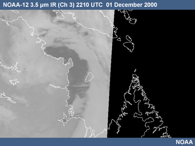
This satellite imagery shows the cloud pattern associated with the upper trough and vorticity advection as it moves eastward over Ungava Bay. Surface observations indicate the passage of the low-level trough between 1800 and 0000 UTC on 01-02 December with the associated westerly winds and cold advection to the west of the trough. From the NOAA-12 IR 2211 UTC satellite imagery, it is clear that cloud streamers are forming over the open water of western Ungava Bay in the cold westerly flow following the passage of the trough.
Triggers and Development: Upper- and Lower-level Interaction
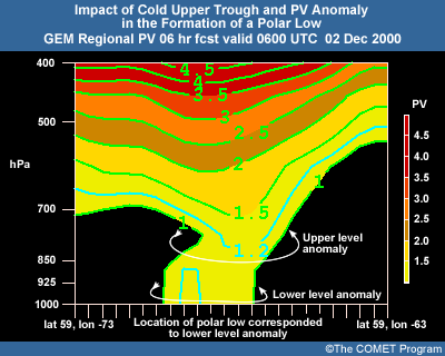
The interaction of certain upper- and lower-level patterns is thought to be important for polar low development and can be examined in a number of ways. One method is the potential vorticity (PV) approach. PV can be used to schematically illustrate how upper-level baroclinicity can reach down in the atmosphere to link up with low-level baroclinicity. In the case of a polar low, the diabatic heating of the cold atmosphere by open water plays a key role.
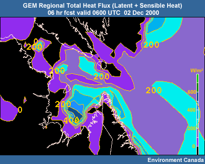
Over southwestern Ungava Bay, the GEM regional 6-hour forecast from 0000 UTC on 02 December defines fluxes of up to 600 watts/m2 leading to diabatic heating in the lower layers of the atmosphere.
Triggers and Development: Upper- and Lower-level Interaction (cont.)
This cross section over Ungava Bay shows PV for the same 6-hour forecast. The 1.2 PVU contour extends downward to around 800 hPa, while another small 1.2 PVU contour is found from about 1000 to 900 hPa over Ungava Bay. This low-level PV max is likely related to the diabatic heating in that area. The 1.2 PVU contour symbolically connects the upper and lower PV maxima. The interaction between upper and lower PV maxima is one way to consider the relationship between upper and lower levels in the polar low development process.
Appearance in Satellite Imagery
Polar lows form in high-latitude areas over oceans or other bodies of water. These are generally data sparse areas, making satellite imagery the primary method of detecting polar lows. Images from polar orbiters are commonly used, while those from geostationary satellites can be used if the low is not too far north. (see 3.1.4 Satellite Imagery Characteristics and 3.2 Use of Satellite Imagery)
By 0515 UTC, the GOES IR imagery shows the old comma cloud rapidly spinning up and beginning to form a more distinct spiral-shape over Ungava Bay. At the height of its development, around 0900 UTC, the polar low has a classic shape with spiral arms whose individual elements have well-defined edges typical of convective cloud.
Surface and Upper-air Observations
Due to their remote location, the forecaster will be lucky to get a ship, buoy, or coastal land station observation close to a polar low. This calls for careful monitoring of all available surface observations for subtle signs involving pressure or wind speed and direction. (See 3.1 Nowcasting)
The GEM Regional surface analysis for 1200 UTC on 02 December does not resolve the polar low. Its MSL pressure is about 1008 hPa at WKW, and 1007 at WRH. The automated analysis shows only an open trough between those two stations, with pressures no lower than 1005 hPa in the trough. In reality, pressure at WKW is 1005 hPa, 3 hPa deeper than the initialization. The observed pressure at WRH is 1008 hPa. The gradient between the stations is tighter than shown by the initialization. In addition, observed winds at WRH are westerly, indicating a closed low rather than the open trough of the initialization.
Click the following link to view a more complete set of station
observations:
Station
Map and Observations
Surface and Upper-air Observations (cont.)
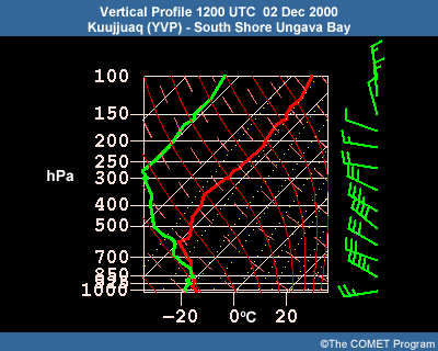
It is very unusual to have a radiosonde observation in the vicinity of a polar low. However, in this case, the station YVP, on the south shore of Ungava Bay, did provide soundings representative of the conditions over Ungava Bay during the development of the polar low. The sounding from this site at 1200 UTC on 02 December illustrates the vertical structure of the very cold air mass in the area. The temperatures between 600 and 500 hPa are near -40ºC, and the lowest level air is at around -18ºC. This air mass, when placed over the open water of Ungava Bay, will exhibit a great deal of instability through a deep atmospheric layer.
Click the following link to view a more complete set of station
observations:
Station
Map and Observations
Model Initialization
It is important to realize the limitations of the NWP guidance. In December 2000, the horizontal resolution of the GEM regional model was 24 km. Since at least 8 grid points are required to define a feature in an NWP model if it is to be well-forecast, wavelike structures with a scale of around 200 km, the approximate size of Ungava Bay, are at the limit of the model's ability. (See A 20 km Grid Accurately Depicts 40 km Features in the Ten Common NWP Misconceptions series for more discussion of this point).
NWP models depend on accurate initial analyses, but the high-latitude areas in which polar lows form are generally data-sparse areas in terms of traditional observational data. This means that model trial fields (first-guess fields) can be inadequate in these areas. Satellite data have barely started to fill the data void. For these reasons, the initial analysis of a NWP model can be incorrect on the details of position and depth of a small-scale high-latitude feature such as a polar low.
Another potential analysis problem is with the ice coverage used by the model. Ice analyses may be done on relatively coarse grids, so features such as ice-water boundaries can be "smeared out," even if there are adequate ice observations. During the polar low event, there is a discrepancy between the amount of ice coverage used by the GEM Regional model versus the coverage as interpreted by the Canadian Ice Service. Since the latter is based more closely on actual observations, it is considered a more accurate representation. Compare the GEM Regional analysis for the following 00-hour forecasts to the Canadian Ice Service product.
Dissipation
Polar lows will quickly lose their strength and decay as they cross over land or ice surfaces. (See1.3.5 Dissipation of Polar Lows and 5.1.9 Forecasting the Dissipation of Polar Lows)
As noted earlier, the Ungava Bay polar low dissipated as it crossed over the Torngat Mountains. By 1800 UTC, as the polar low moves eastward with the 500 hPa trough, it loses its shape and definition as it makes landfall on the east side of Ungava Bay. It then dissipates over the land of the Torngat mountains. The upper support also moved across the Torngats to the Labrador Sea, where a rather disorganized cyclonic surface pattern formed. The polar low did not reestablish itself over the Labrador Sea. Rather, the cyclonic pattern is best considered as a new and weaker system to the lee of the Torngats.
Resources
A special thanks to Ron Goodson and Ed Hudson with the MSC for all of their efforts in data collection, content writing, and review.
The following resources were used in compiling the Support Topics for this project:
Agee, Ernest M. and Steven R. Gilbert, 1989: An aircraft investigation of mesoscale convection over Lake Michigan during the 10 January 1984 cold air outbreak. J. Atmos. Sci., 46 , No.13, 1877–1897.
Anderson, R.K., J.P. Ashman, F. Bittner, G.R. Farr, E.W. Ferguson, V.J. Oliver, and A.H. Smith, 1969: Applications of meteorological satellite data in analysis and forecasting. ESSA Tech. Rep. NESC 51 [NTIS AD-697 033].
Bader, M.J., G.S. Forbes, J.R. Grant, R.B.E. Lilley, and A.J. Waters, 1995: Images in Weather Forecasting. Cambridge University Press.
Broadfoot, D. 1990: 12 December 1989. Lake Superior polar low, unpublished presentation.
Businger, Steven, 1987: The synoptic climatology of polar low outbreaks over the Gulf of Alaska and the Bering Sea. Tellus, 39A , 307-325.
Businger, S. and R. Reed, 1989: Cyclogenesis in cold air masses. Wea. Forecasting, 4. No. 2, 133-156.
Carleton, Andrew, 1985: Satellite climatological aspect of the "polar low" and "instant occlusion."Tellus, 37A , 433-450.
Charney, J. and A. Eliassen, 1964: On the growth of the hurricane depression. J. Atmos. Sci., 21, 68-75.
COMET Module: Satellite Meteorology: GOES Channel Selection. [Available online at hhttps://www.meted.ucar.edu/satmet/goeschan/]
Duncan, C.N., 1978: Baroclinic instability in a reversed shear flow. Meteor. Mag. 107, 17-23.
Emanuel, Kerry, A., 1986: A two stage air sea interaction theory for polar lows. Proc., The Third International Conference on Polar Lows, Norway.
Emanuel, Kerry A. and Richard Rotunno, 1989: Polar lows as arctic hurricanes. Tellus, 41A , 1-17.
Hanley, D. and W.G. Richards, 1991: Polar Lows in Atlantic Canadian Waters 1977 - 1989. Report: MAES 2-91. Scientific Services Division, Atlantic Region, Atmospheric Environment Service.
Harrold, T.W. and K.A. Browning, 1969: The polar low as a baroclinic disturbance. Quart. J. Roy. Meteor. Soc., 95, 710-723.
Heinemann, Günther, 2001: Newsletter of the European Polar Low Working Group, September 2001.
Heinemann, Günther, 2003: Proc. European Geophysical Society (EGS) Polar Low Workshop, Cambridge, UK, 11-13 June 2003.
Heinemann, G., 2003. Interaction of katabatic winds, mesocyclones and sea ice formation. Proc. Ninth meeting of the EGS Polar Lows Working Group, Cambridge, UK.
Hewson, T.D., G.C. Craig, and C. Claud, 2000: Evolution and mesoscale structure of a polar low outbreak, Quart. J.Roy. Meteor. Soc., 126, 1031-1063.
Holton, James, R., 1992: Introduction to Dynamic Meteorology. 3d ed. Academic Press Ltd., London, U.K.
Lystad, M., 1986: Polar lows in the Norwegian, Greenland and Barents Sea - Final Report. Norwegian Meteorological Institute, Oslo, Norway, 196 pp.
Mailhot J., D. Hanley, B. Bilodeau, and O. Hertzman, 1996: A numerical case study of a polar low in the Labrador Sea. Tellus, 48A , 383-402.
Midtbø, K.H., 1986: Polar low forecasting. Proc. Third International Conference on Polar Lows , Norway.
Moore, G.W.K., M.C. Reader, J. York, and S. Sathiyamoorthy, 1996: Polar lows in the Labrador Sea: A case study. Tellus, 48A, 17-40.
Moore, Richard W. and T.H. Vonder Haar, 2003: Diagnosis of a polar low warm core utilizing the Advanced Microwave Sounding Unit. Wea. Forecasting, 18, 700-711.
Mullen, S., 1983: Explosive cyclogenesis associated with cyclones in polar air streams. Mon. Wea. Rev., 111, 1537-1553.
Naval Tactical Applications Guide. Vol. 8. Part 2, Arctic. East Siberian/Chukchi/Beaufort Seas. NRL/PU/7541 92-0005.
Noer, G. and M. Ovhed, 2003: Forecasting of polar lows in the Norwegian and the Barents Sea. Proc. Ninth meeting of the EGS Polar Lows Working Group, Cambridge, UK.
Nordeng, Thor Erik, and Erik A. Rasmussen, 1992: A most beautiful polar low: A case study of a polar low development in the Bear Island region. Tellus, 44A, 81-99.
Øakland, Hans, 1989: On the genesis of polar lows. Polar and Arctic Lows. Twitchell, P., E. Rasmussen, and K. Davidson, Eds., A. Deepak Publishing.
Online Manual of Synoptic Satellite Meteorology, Central Institute for Meteorology and Geodynamics, Zentralanstalt für Meteorologie und Geodynamik. [Available online at http://www.zamg.ac.at/docu/satmanu4.0/satmanu/manual/PL/pl0.htm]
Parker, Neil, 1997: Cold Air Vortices and Polar Low Handbook for Canadian Meteorologists . Environment Canada.
Parker, M.N. and Edward Hudson, 1991: Polar Low Handbook for Canadian Meteorologists. Environment Canada, Atmospheric Environment Service.
Parker, M.N, 1992: Polar lows in the Beaufort Sea and Davis Strait. Proc. Applications of New Forms of Satellite Data in Polar Low Research, Polar Low Workshop, Hvanneyri, Iceland.
Rasmussen, Erik A. and P.D. Aakjær, 1989: Two polar lows affecting Denmark. Vejret, Special Issue in English, The Danish Meteorological Society.
Rasmussen, Erik A., John Turner, and Paul Twitchell, 1992: Applications of new forms of satellite data in polar low research. Bull. Amer. Meteor. Soc., 74, 1057-1073.
Rasmussen, Erik A., and Anette Cederskov, 1994: Polar lows: A critical analysis. The life cycles of extratropical cyclones. Vol. 111. Proc. of an International Symposium, Bergen, Norway.
Rasmussen, Erik A., 1995: Polar Lows News - The Newsletter of the EGS Polar Lows Working Group. June 9, 1995, No 5. Dr. G. Heinemann, Chairman.
Rasmussen, Erik A., Chantal Claud, and James F. Purdom, 1996: Labrador Sea polar lows. The Global Atmosphere and Ocean System, Vol. 4, 275-333.
Rasmussen, Erik A., and John Turner, 2003: Polar Lows: Mesoscale Weather Systems in the Polar Regions, Cambridge University Press.
Reed, R., 1979: Cyclogenesis in polar air streams. Mon. Wea. Rev., 107, 38-52.
Reed, R. and C. Duncan, 1987: Baroclinic instability as a mechanism for serial development of polar lows: A case study. Tellus, 39A, 376-384.
Renfrew, Ian, G.W.K. Moore, and Aashish A. Clerk, 1996: Binary interactions between polar lows. Submission to Tellus, 22 November 1996; also Extended Abstract, Workshop on Theoretical and Observational Studies of Polar Lows, St. Petersburg, Russian Federation, 23-26 September 1996.
Shapiro, M.A., L.S. Fedor, and Tamara Hampel, 1987: Research aircraft measurements of a polar low over the Norwegian Sea. Tellus, 39A, 272-306.
Shapiro, M.A., T. Hampel, and L.S. Fedor, 1989: Research aircraft observations of an arctic front over the Barents Seas. Polar and Arctic Lows, Polar and Arctic Lows. Twitchell, P., E. Rasmussen, and K. Davidson, Eds., A. Deepak Publishing.
Wilhelmsen, K., 1985: Climatological study of gale-producing polar lows near Norway. Tellus, 37A, 451-459.
Yarnal, B. and Henderson, G., 1988: A satellite-derived climatology of polar-low evolution in the North Pacific. Int. J. Climatology, 9, 551-566.
Zick, 1983: Method and results of an analysis of comma cloud developments by means of vorticity fields from upper tropospheric satellite wind data. Meteor. Rundsch. 36, 69-84.
Contributors
COMET Sponsors
- Air Force Weather Agency (AFWA)
- Environment Canada Meteorological Service of Canada (MSC)
- National Environmental Satellite, Data, and Information Service (NESDIS)
- Naval Meteorology and Oceanography Command (NMOC)
- National Oceanic and Atmospheric Administration (NOAA)
- National Weather Service (NWS)
Principal Science Advisors
- Patrick Dills — UCAR/COMET
- Ron Goodson — MSC
- Noer Gunnar — Norwegian Meteorological Institute
- Ed Hudson — MSC
- Garry Toth — MSC
- Julie Turner — UK MetOffice
Project Lead/Instructional Design
- Bruce Muller — UCAR/COMET
- Patrick Parrish — UCAR/COMET
Multimedia Authoring
- Bruce Muller — UCAR/COMET
- Dan Riter — UCAR/COMET
Audio Editing/Production
- Seth Lamos — UCAR/COMET
Audio Narration
- Dan Riter — UCAR/COMET
Computer Graphics/Interface Design
- Heidi Godsil — UCAR/COMET
Illustration/Animation
- Steve Deyo — UCAR/COMET
Software Testing/Quality Assurance
- Michael Smith — UCAR/COMET
Copyrights Administration
- Lorrie Fyffe — UCAR/COMET
Data
- MSC
- NWS - NOAA
COMET HTML Integration Team 2021
- Tim Alberta — Project Manager
- Dolores Kiessling — Project Lead
- Steve Deyo — Graphic Artist
- Ariana Kiessling — Web Developer
- Gary Pacheco — Lead Web Developer
- David Russi — Translations
- Tyler Winstead — Web Developer
COMET Staff, 2004
Director
- Dr. Timothy Spangler
Deputy Director
- Dr. Joe Lamos
Business Manager/Supervisor of Administration
- Elizabeth Lessard
Administration
- Lorrie Alberta
- Heather Hollingsworth
- Bonnie Slagel
Graphics/Media Production
- Steve Deyo
- Heidi Godsil
- Seth Lamos
- Dan Riter
Hardware/Software Support and Programming
- Tim Alberta (Supervisor)
- James Hamm
- Karl Hanzel
- Andrew Jurey (Student)
- Ken Kim
- Mark Mulholland
- Carl Whitehurst
Instructional Design
- Patrick Parrish (Supervisor)
- Dr. Alan Bol
- Lon Goldstein
- Dr. Vickie Johnson
- Bruce Muller
- atherine Olson
- Dwight Owens
- Dr. Sherwood Wang
Meteorologists
- Dr. William Bua
- Patrick Dills
- Tom Dulong
- Kevin Fuell
- Patrick Hofmann (Student)
- Dr. Stephen Jascourt
- Matthew Kelsch
- Dolores Kiessling
- Heather McIntyre (Student)
- Wendy Schreiber-Abshire
- Dr. Doug Wesley
Software Testing/Quality Assurance
- Michael Smith (Coordinator)
National Weather Service COMET Branch
- Anthony Mostek (NWS COMET Branch Chief [acting] and Satellite Training Leader)
- Brian Motta
- Dr. Robert Rozumalski (SOO Science and Training Resource [SOO/STRC] Coordinator)
- Shannon White (IFPS Training)
Meteorological Service of Canada Visiting Meteorologists
- Peter Lewis
- Garry Toth