Produced by The COMET® Program
Case Setting
Case Introduction
This case presents a blowing snow forecast challenge over north-central Canada. The time period of interest is from 04 to 10 February 2003. The case addresses specific low-level wind and snow conditions over the central mainland region of Nunavut. You'll be asked to assess the potential for blowing snow and blizzard conditions for the Baker Lake region of Nunavut.
Location of Interest: Baker Lake, Nunavut
Case Time Frame: 04 Feb - 10 Feb 2003
Phenomenon of Interest: Blowing Snow
Forecasting Challenges:
- Recognize common synoptic patterns of a blowing snow event
- Forecast wind speed and direction, and the duration of blowing snow events
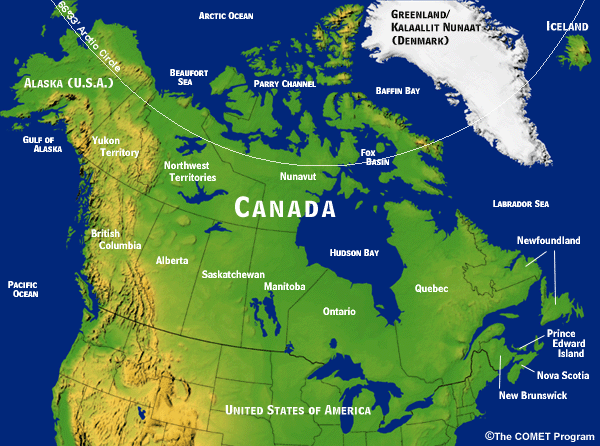
About the Nunavut Territory
Nunavut spans across a vast stretch of northern Canada, covering 2 million square kilometers—a fifth of Canada's total landmass. Most of its land lies north of tree line. This sparsely populated territory stretches from the coast of the Beaufort Sea in the west, across the Hudson Bay to Baffin Island in the east, and from Manitoba in the south, to the northern-most Queen Elizabeth Islands. With all its islands and open stretches of tundra, there are few roads connecting the 29,000 residents. Air travel is the primary means of transport between communities, while snowmobiles and all-terrain vehicles are commonly used for local travel.
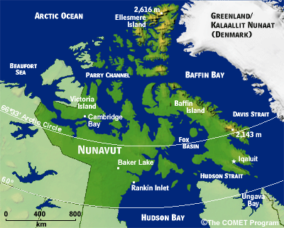
About Baker Lake
The specific area of interest for this case is Baker Lake, which is near the geographic center of Canada. Baker Lake is Canada's only inland Inuit community and has around 1,500 full time residents. Located in the central mainland region of Nunavut, it sits at the mouth of the Thelon River on the northwestern edge of Baker Lake. The lake stretches eastward towards an inlet of Hudson Bay, 320 km away. In the summer, the town is a jumping off point for hunting, fishing, and canoe trips. Year around, the town is dependent on air travel for supplies.

Baker Lake Winter Climatology
Located as far north as it is, Baker Lake experiences cold and dark winter months. The climatology listed here provides an overview of what to expect in Baker Lake during the winter months.
| Baker Lake Climatology (sampling period: 1971 to 2000) | ||||
|
Dec
|
Jan
|
Feb
|
March
|
|
| Temperatures: daily average (°C) |
-28.4
|
-32.3
|
-31.5
|
-27.2
|
| Temperatures: daily maximum (°C) |
-24.8
|
-28.7
|
-27.9
|
-22.9
|
| Temperatures: daily minimum (°C) |
-31.9
|
-35.8
|
-35.1
|
-31.5
|
| Average snow depth (cm) |
34
|
40
|
45
|
51
|
| Days with snowfall >= 0.2 cm |
8.6
|
6.9
|
7.3
|
8.3
|
| Days with snowfall > 5.0 cm |
0.46
|
0.23
|
0.29
|
0.59
|
| Wind speed (km/h) |
22.7
|
23.7
|
22.9
|
21.6
|
| Most frequent direction |
NW
|
NW
|
NW
|
NW
|
| Days with wind >= 52 km/h (28 kt) |
7.9
|
10.8
|
9.6
|
7.9
|
| Visibility: hours with <1 km |
82.4
|
118.9
|
89.7
|
68.1
|
|
Environment Canada
|
||||
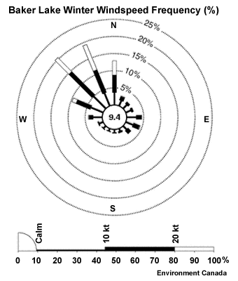
Winds and Blowing Snow in Baker Lake
During the winter, Baker Lake residents deal with fairly constant winds and frequent blowing snow conditions. Average winds in February blow at more than 12 knots.
Baker Lake Winter Windspeed Frequency Content
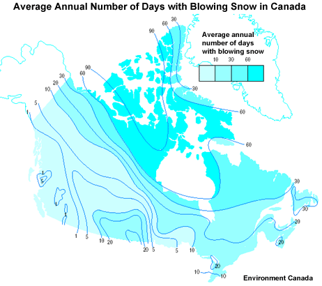
Average Annual Days with Blowing Snow Content
NAV CANADA's wind thresholds for forecasting drifting snow, blowing snow, and blizzard conditions in the absence of falling snow for most of the Nunavut region:
- Drifting snow: 12 kt
- Blowing snow: 19 kt
- Blizzard conditions:
22 kt for periods of blizzard conditions
25 kt for sustained conditions
30 kt
for guaranteed blizzard conditions
See Thresholds for Blowing Snow and Blizzard Conditions in the Supporting Topics area for more information.
Blizzards in Baker Lake
It is safe to say that Baker Lake is the blizzard capital of Canada. Between 1980 and 1999, residents there had to cope with an average of 91 blowing snow days and over 20 blizzard events per year!
Forecasting in the North
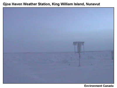
The MSC's Arctic Weather Centre in Edmonton issues forecasts for all of Nunavut. Given the sparse population and remote location of most communities, the forecasters in Edmonton have to deal with a number of limitations. Foremost, the network of surface stations is much sparser than in the south. A few of these remote stations can be viewed using a Webcam. The example shown here is located on the southeast coast of King William Island, where for much of the winter, the sun is low or below the southern horizon.
Given the latitude of the region, geostationary satellite (GOES) data is of limited use. Verification is much more dependent on the use of polar-orbiting sensors (POES). It's important to keep in mind that POES data does not come in as regularly as GOES data, and the availability of POES imagery is tied to the orbital paths of the satellites.
Case Exercise
Case Setup: Upper-level Pattern and Winds

With the Baker Lake area setting and forecast limitations in mind, let's take a look at conditions early on 04 February 2003.
- The GEM Regional model is used throughout this case.
- The 00-hour analysis will be used to show current conditions, while 48-hour forecasts are used to support forecast questions.
- Be sure to take note of the timeline as you progress through the case.
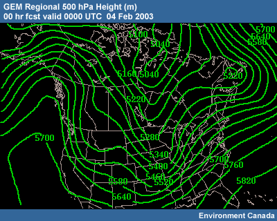
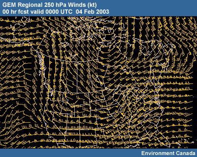
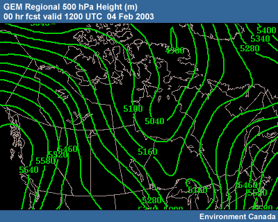
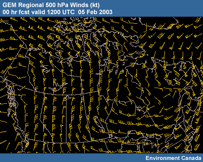
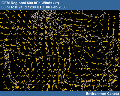
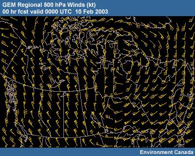
The upper-level pattern at 0000 UTC shows a high-amplitude ridge over the Yukon Territory that extends southward over the Pacific off the coast of British Columbia. Downstream of the ridge is a major trough.
A branch of the polar jet stream is rounding the base of the trough over southwestern U.S., and another branch of the polar jet stream defines the trough farther north over Hudson Bay, northwestern Ontario, and the midwestern U.S.
GEM Regional 500 hPa Height (m) Content
GEM Regional 250 hPa Winds (kt) Content
Surface Pattern and Temperatures
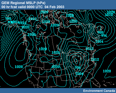
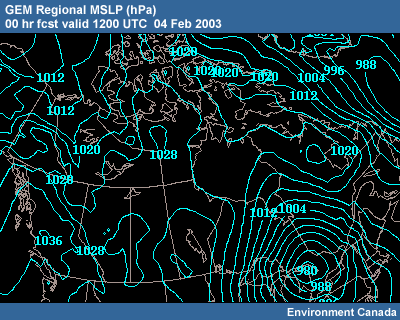
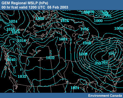
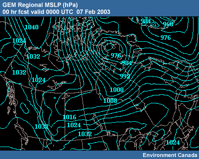
The MSLP pattern shows high pressured centered off Vancouver Island and another large area of high pressure over the eastern Canadian prairies and Nunavut. A 988 hPa low lies over southwestern Alaska, while a weak low has formed over the Beaufort Sea. Relatively low pressure extends from the southern Arctic Ocean across the Northwest Territories and into Alberta.
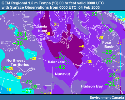
The temperatures in mainland Nunavut are very cold, in the -30 to -40ºC range.
GEM Regional MSLP (hPa) Content
GEM Regional 1.5m Temps (°C) Content
Developing Frontal System
Take a look at the GEM Regional forecast for MSLP and the 1000-500 hPa thickness.
Note that the previously mentioned ridging, centered from Nunavut southward, is being squeezed from the north by a developing surface frontal system. From southern Nunavut northward, the MSLP gradient is generating westerly geostrophic winds and is tightening.
MSLP contours are becoming cyclonically curved ahead of a cold front located approximately over Victoria Island, just north of mainland Nunavut.
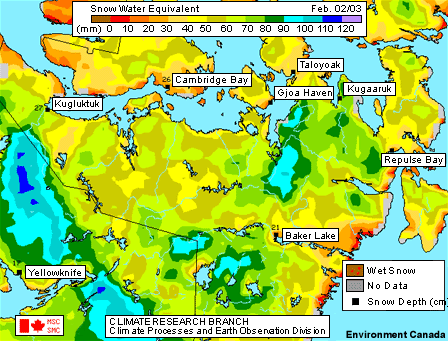
Snow Coverage
A look at a recent snow-water equivalent analysis shows snow coverage throughout most of Nunavut, including significant amounts to the north and southwest of Baker Lake.
Amplification of Upper Ridge and Trough
Not much has changed 8 hours later. Although aloft some amplification of the upper ridge and trough system is evident, with troughing in southeastern Canada intensifying and slowing. The gradient over western Canada is strengthening somewhat behind a short wave. Fairly strong north-northwesterly to north-northeasterly flow is present over the Northwest Territories, Alberta, and Saskatchewan.
At the surface, the intense low pressure system has moved over Lake Huron and is heading northeastward. The Beaufort Sea low pressure is still evident but relatively weak, and lee troughing is developing over the western Northwest Territories. Moderately strong high pressure dominates British Columbia, and weak high pressure extends up into southern and central Nunavut.
GEM Regional 500 hPa Height (m) Content
GEM Regional MSLP (hPa) Content
Forecast Question 1
Question

The time is now 0400 UTC on 05 Feb. Twenty-four hours ago, based on the model, it looked like things were setting up for a frontal passage across the Baker Lake area sometime on 06 February.
Take a look at the GEM Regional forecasts for the next 48 hours. Compare the forecast to the following four generalized MSLP and 500 hPa synoptic patterns. Each of these patterns represents a potential for blowing snow over the yellow area of interest. In this case, our area of interest is northern mainland Nunavut, northwest of the Hudson Bay. Which of these synoptic patterns is most likely to set up over that area in the next 24-48 hours?
| Available Data | ||
|
Model Output
|
Satellite
|
Other
|
| GEM Regional Loops GEM Regional 48-hr fcst initialized 00 UTC 05 Feb 2003 CMC
4-Panels
|
|
|
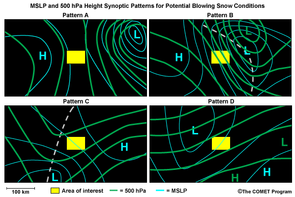
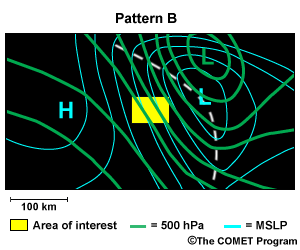
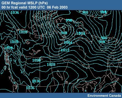
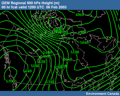
The correct answer is b).
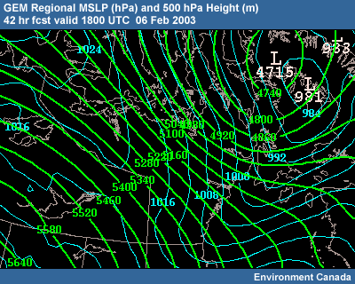
The B pattern is the most likely to set up in the next 24-48 hour time frame. Here we compare it to the GEM Regional 42-hour forecast.
That forecast is predicting the following:
MSLP
A surface trough develops over
north central Canada and extends from western Baffin Island southwestward into
northern Saskatchewan. Behind the system, a 1038 hPa high is centered over the
Arctic Ocean, and strong northwesterly gradient flow develops over northern
Nunavut.
500 hPa Heights
A cutoff low (4715 m) is located over western portions of Baffin
Island, with very intense northwesterly flow over mainland Nunavut.
Pattern B Content
GEM Regional MSLP (hPa) and 500 hPa Height (m) Content
Forecast Question 2
Question
As a surface trough approaches Baker Lake, do you anticipate blowing snow for the 0000-0600 UTC 06 Dec period? What about later in the forecast period, between 0600-1800 UTC on 06 Feb?
| Available Data | ||
|
Model Output
|
Satellite
|
Other
|
|
GEM
Regional Loops UMOS Winds - interactive map CMC 4-Panels |
NOAA-17
IR, Northern Canada |
Arctic
Weather Center MSC Snow-Water Equivalent MSC Snow-Water Equivalent Change Surface Station Observations |
| Supporting Topics | ||
| Thresholds for Blowing Snow and Blizzard Condition | ||
Conditions for Baker Lake: 0600 -1800 UTC 06 Feb
The correct answer are a) and e).
Conditions for Baker Lake: 0000-0600 UTC 06 Feb Content
No blowing snow or very minor blowing snow until the front passes
For 05 Feb, the Arctic Weather Center Snow Analysis indicates 21 cm at Baker Lake. It categorizes the snow in the Baker Lake area as C4: uneven layer of compact snow.
The UMOS wind forecast for YBK (Baker Lake) shows 8-10 knots from the southwest for this time period. Looking at stations upstream, to the northwest, UMOS winds are significantly higher behind the developing front. The GEM Regional 24-hr forecast MSLP shows the cold front approaching but definitely not reaching the Baker Lake area in this time period. Prefrontal geostrophic west-southwesterly flow appears to dominate during the period.
Referring to the windrose, strong southwest winds are climatologically rare to nonexistent in Baker Lake during the winter months.
Conditions for Baker Lake: 0600 -1800 UTC 06 Feb Content
Blowing snow beginning shortly after the frontal passage and becoming significant
According to the UMOS winds and the GEM Regional MSLP forecast, a front passes through Baker Lake between 0900 and 1200 UTC 06 February. The GEM Regional model shows a strong pressure rise and an intense northwesterly gradient flow developing behind the front. From 1200 to1800 UTC the UMOS winds are 25-35 kt from the northwest.
Given the predicted winds, snow on the ground, and the potential for snowfall, you can expect significant blowing snow to develop post-frontally at Baker Lake.
Intensification
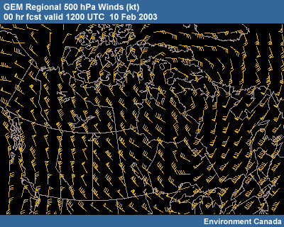
As the day progresses, the anticyclonic flow around the ridge aloft continues to strengthen.
70 to 90 knot northwesterly to northerly flow at 500 hPa now extends from the Beaufort Sea through the Northwest Territories and Alberta. A wave and associated westerly jet streak are apparent over the Beaufort Sea. The cyclonic flow in the large long-wave trough extends from Saskatchewan eastward.
At the surface, an intensifying trough has developed in association with the wave aloft and is moving southeastward from Victoria Island. Significant ridging is now pushing southeast from the Beaufort Sea. The intense low is now over central Quebec, heading northeast, with blowing snow reports appearing over northern Quebec. Ridging persists between these two features, with a 1030 hPa high centered over southern Nunavut.
GEM Regional 500 hPa Height (m) Content

GEM Regional 500 hPa Winds (kt) Content
GEM Regional MSLP (hPa) Content
Forecast Question 3
Question
Light southwesterly winds are being observed at Baker Lake at this time. We are now only 4-6 hours away from the predicted frontal passage. Will your forecast for the 00-24 hour time period include blizzard conditions for Baker Lake?
| Available Data | ||
|
Model Output
|
Satellite
|
Other
|
|
GEM
Regional Loops UMOS Winds - interactive map CMC
4-Panels |
NOAA-17
IR, Northern Canada |
Arctic
Weather Center CMC Snow
on the Ground Analysis Surface Station Observations |
| Supporting Topics | ||
| Thresholds for Blowing Snow and Blizzard Condition | ||
The correct answer is a).
Yes, it makes sense to include blizzard conditions in the forecast for the Baker Lake region beginning approximately 0900 UTC on 06 Feb.
The trough is forecast to pass over Baker Lake around 0900 UTC on 06 Feb. At 0000 UTC, the surface front is located about 300 km to the north and west of Baker Lake, but it is approaching rapidly.
The surface winds at Baker Lake in the 0000 UTC model run are forecast to be from the northwest and consistently above 23 knots after frontal passage. The 24-hour forecast for 0000 UTC on 07 Feb shows an intense northwesterly gradient flow over Baker Lake, and the upstream reinforcement of this flow is evident.
As previously forecast, the winds, together with the existing snow on the ground and potential light snow that will fall as the front passes, point towards blizzard conditions.
Blizzard Conditions Set In
As predicted, by this time the trough has passed over Baker Lake. Observations for the past 12 hours show that there have been periods of snowfall and blowing snow conditions. And by 1100 UTC, winds passed the 22 knot threshold for blizzard conditions.
The surface trough over Nunavut is now intense. It extends from the low's center in the northeast, southwestward across the Territory. Behind the system, the high over the Arctic Ocean has strengthened slightly to 1039 hPa (just off the MSLP map). Northwest of the trough, strong northwesterly winds extend back across the Queen Elizabeth Islands, and the ice of the Arctic Basin to the North Pole.
At 500 hPa, the cutoff low is now at 4760 m and located just southwest of the western tip of Baffin Island. This is creating a strong northwesterly flow over Victoria Island and mainland Nunavut.
GEM Regional MSLP (hPa) Content
GEM Regional 500 hPa Height (m) Content
GEM Regional 500 hPa Winds (kt) Content
Observations: Baker Lake (CYBK) Content
CYBK - Baker Lake 71926 BAKER LAKE ARPT & UA NT CN 64'18N 96'05W
18m
CYBK 060000Z 18002KT 15SM SCT020 BKN210 M32/M36 A3016 RMK SC3CI2 SLP217
CYBK 060100Z 22006KT 15SM SCT020 BKN210 M31/M36 A3011 RMK SC3CI2 SLP199
CYBK
060200Z 21008KT 2 1/2SM IC OVC015 M29/M34 A3005 RMK SC8 SLP180
CYBK 060300Z
22012KT 1 1/2SM -SN OVC012 M27/M31 A2999 RMK SN3SC5 PRESFR SLP160
CYBK 060400Z
22010KT 1SM -SN OVC015 M25/M30 A2992 RMK SN3SC5 PRESFR SLP136
CYBK 060500Z
22014KT 3/4SM -SN OVC012 M21/M25 A2985 RMK SN3SC5 PRESFR SLP111
CYBK 060600Z
24018KT 3/4SM -SN OVC015 M20/M24 A2979 RMK SN3SC5 PRESFR /S07/ SLP092
CYBK
060700Z 25025KT 1/2SM -SN BLSN OVC015 M17/M20 A2969 RMK SN4SC4 PRESFR SLP059
CYBK 060800Z 26015KT 1/2SM -SN BLSN OVC015 M17/M20 A2969 RMK SN6SC2 SLP059
CYBK
060900Z 28017KT 3/4SM -SN BLSN OVC015 M16/M19 A2962 RMK SN6SC2 PRESFR SLP032
CYBK 061000Z 29013KT 1 1/2SM -SN BLSN OVC015 M15/M18 A2959 RMK SN3SC5 SLP024
CYBK 061100Z 33026G34KT 1/2SM -SN BLSN OVC015
M13/M16
CYBK 061200Z 35035G40KT 1/8SM IC
+BLSN SKC M18/M22 A2958 RMK BLSN7 /S05/ SNW CVR/MUCH LOOSE SLP021
Satellite Verification
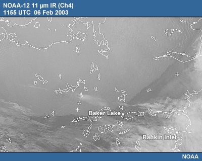
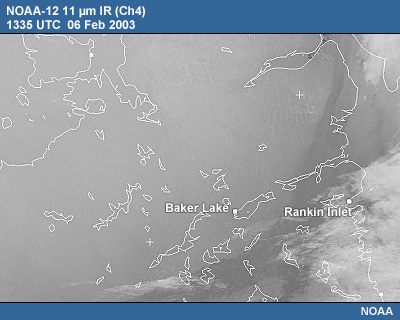
Looking at imagery from the polar-orbiting NOAA-12 satellite, the 11 micrometer IR shows the cold air mass making its way southeastward across Nunavut. At 1155 UTC, the leading edge of the air mass has not yet passed over Baker Lake. By 1335 UTC it is to the south of town. The surface observations at Baker Lake show a drop of 10ºC during that time.
At first glance it may be tempting to think the 11 micrometer IR is showing low-level cloud or blowing snow as the front heads southeast. But in this situation, the 11 micrometer IR is showing sensitivity to differences in temperatures between the very cold air moving in from the northwest and the air mass ahead of it.
How could this be? Especially since the 11 micrometer IR is commonly referred to as an atmospheric "window" channel, supposedly only seeing energy from cloud top and surface? It is true that the 11 micrometer is relatively insensitive to atmospheric gases, but there is just enough sensitivity to low-level water vapor to bias the observed brightness temperatures toward the temperature of the low-level air mass. The larger the temperature contrast between air masses and the more moist the air masses, the greater the effect on the 11 micrometer IR brightness temperatures.
NOAA-12 11 μm IR (Ch4) 1155 UTC Content
NOAA-12 11 μm IR (Ch4) 1335 UTC Content
Surface Observations Content
Forecast Question 4
Question
How widespread are the blowing snow conditions at this point? Take a look at the MODIS satellite products (MODIS VIS/IR, Baker Lake). Be sure to switch between the two available times, 1730 and 1740 UTC. Evaluate and take note of the motion of the features in this imagery. Then drag and drop the five correct features onto the MODIS 2.1 micrometer image here:
| Available Data | ||
|
Model Output
|
Satellite
|
Other
|
|
|
NOAA-12
IR, Northern Canada MODIS
VIS/IR, Baker Lake |
Surface Station Observations Surface station observations across Nunavut for 0800-1800 UTC 06 Feb 2003 |
| Supporting Topics | ||
| Satellite Detection of Blowing Snow | ||
Drag the features listed below to the features highlighted in the image.
The Answer Content
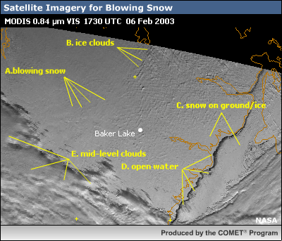
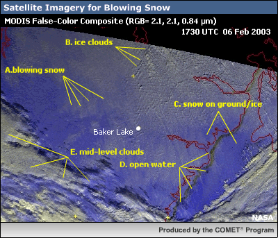
2.1 micrometer shortwave IR Content
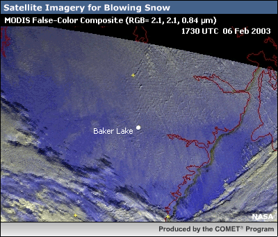
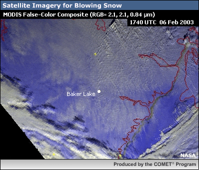
The MODIS imagery shows widespread areas of blowing snow. Using the fader and time selectors to switch between the images, cloud, ground, and blowing snow features become identifiable.
The 2.1 micrometer shortwave IR is helpful in distinguishing the blowing snow from the snow covered ground and ice. In the visible image, the shadows cast by the clouds helps to set them apart from the snow-covered ground. The false-color composite allows these features to stand out even more sharply. By switching between the 1730 and 1740 time points, the motion of the blowing snow becomes apparent.
Note that in the false-color composite image, certain areas, such as the open water along the Hudson Bay coast and the clouds in the lower left, have a yellowish tinge. Due to the characteristcs of the 2.1 micrometer shortwave IR and the 0.84 micrometer visible channels, this shading indicates the presence of some liquid water in addition to ice crystals. It is for this reason that the clouds in the lower left are likely mid-level rather than cirrus.
For more details on the use of satellite imagery in this situation, see Applications of Multi-Spectral Satellite Imagery for the Detection of Blowing Snow.
Gradient Continues Strengthening
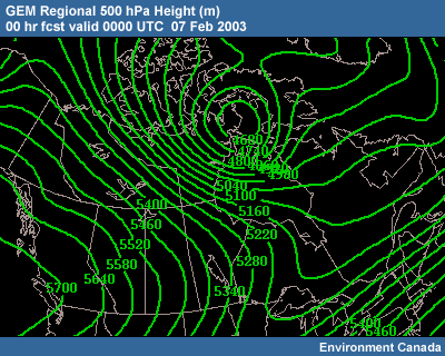
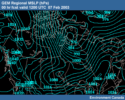
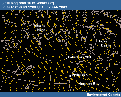
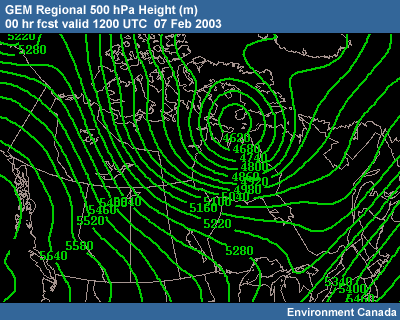
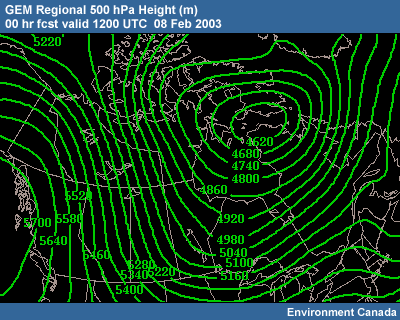
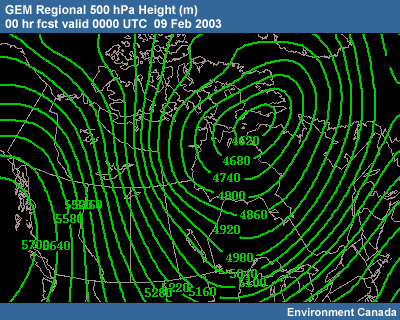
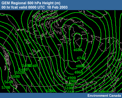
The deep surface low continues to develop into 07 Feb, with a center at less than 972 hPa. To the northwest, the high pressure over the Arctic Ocean builds to 1046 hPa (just off the map). The gradient between the low and the high is strengthening, as are the northerly winds.
The main surface trough sweeps south to southwest, across central Hudson Bay, and continues west across northern Manitoba and northern Saskatchewan. This elongated trough is evidence of the extensive nature of the conditions favorable for strong winds. With snow on the ground in most parts of the region, blizzard conditions persist for most communities behind the trough.
At 500 hPa, a strong 4630 m cutoff is over the extreme northern portion of Hudson Bay, with continued strong northwesterly flow over the eastern Northwest Territories, southern Nunavut, and the northern Hudson Bay region. To the east, the western portion of the long-wave trough is weakening rapidly—“shearing off”—and becoming more positively-tilted. The new, digging cutoff is new reinforcement for the old long-wave trough.
GEM Regional MSLP (hPa) Content
GEM Regional 10 m Winds (kt) Content
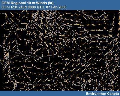
GEM Regional 500 hPa Height (m) Content
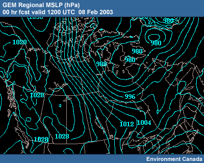
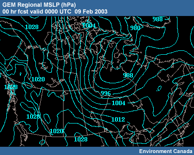
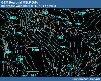
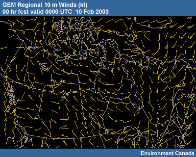
Continued Strengthening
And things just continue to build. Strong northwesterly surface flow now reaches well into the Hudson Bay as the tight surface gradient moves southward and southeastward.
The surface low is just northeast of Southampton Island and nearly stationary. The strong high has built from the Arctic Basin southeastward to eastern Great Bear Lake, and continues south-southeastward into northern Manitoba. The intense pressure gradient, with isobars oriented pretty much north-south, is creating high winds consistently above 22 knots across the region. Baker Lake reports blizzard conditions with gusts over 40 knots.
To the south, in central Manitoba, a secondary low pressure system is evident along the trough and is moving southward fairly rapidly. This secondary low is located on the arctic front.
At 500 hPa, the still-strengthening cutoff low, now 4580 m, is nearly stationary. The strong northwesterly flow is entrenching itself west and southwest of the cutoff, with strong flow sagging into northern Alberta and Saskatchewan.
GEM Regional MSLP (hPa) Content
GEM Regional 10 m Winds (kt) Content
GEM Regional 500 hPa Height (m) Content
Surface Observations: Baker Lake (CYBK) Content
CYBK - Baker Lake 71926 BAKER LAKE ARPT & UA NT CN 64'18N
96'05W 18m
CYBK 070000Z 32030G36KT 1/4SM +BLSN BKN200
M33/M38 A2969 RMK BLSN2CI3 PRESFR SLP057
CYBK 070100Z 31028G34KT 1/4SM IC +BLSN SCT200 M33/M37
A2968 RMK BLSN2CI1 SLP054
CYBK 070200Z 32031G38KT
1/8SM IC +BLSN BKN200 M33/M37 A2966 RMK BLSN3CI1 SLP045
CYBK 070300Z 32035G43KT 1/8SM IC +BLSN BKN200 M33/M38
A2961 RMK BLSN3CI2 PRESFR SLP030
CYBK 070400Z
33037G43KT 1/8SM IC +BLSN SKC M34/M38 A2964 RMK BLSN4 SLP040
CYBK
070500Z 34022G28KT 1/4SM IC +BLSN SCT200 M34/M39
A2971 RMK BLSN2CI0 SLP064
CYBK 070600Z 32033G39KT
1/8SM IC +BLSN SKC M35/M39 A2966 RMK BLSN5 SLP047
(breaks in obs from
0700 to 1200)
Forecast Question 5
Question
Looking at the surface observations, Baker Lake reported winds in the 25-35 knot range with intermittent ice crystals falling early on 07 Feb. Then the data feed went out sometime after 0400 UTC. In general, only isolated light snow showers have been observed in the region over the past 24 hours. Previous to that, the Arctic Weather Center's 24-hr Precipitation Analysis for 06 Feb does show an 11 mm accumulation of precipitation at Baker Lake.
Do you think you can back off the forecast of blizzard conditions within the next 48 hours?
| Available Data | ||
|
Model Output
|
Satellite
|
Other
|
|
GEM
Regional Loops UMOS Winds - interactive map GEM Regional 48-hr fcst initialized 00 UTC 08 Feb 2003 |
|
Arctic Weather Center 24-hr Precipitation
Analysis CMC Snow
on the Ground Analysis Surface Station Observations |
| Supporting Topics | ||
| Thresholds for Blowing Snow and Blizzard Condition | ||
The correct answer is b).
To this point, the GEM Regional model has accurately portrayed surface winds in the Baker Lake area. Based on the model predictions, the strong northwesterly gradient flow persists right on through 0000 UTC on 10 Feb at Baker Lake. During the 42-48 hour time period UMOS winds do decrease to 20-25 knots, but it would be hard to justify forecasting moderating conditions two days ahead.
Slight Weakening of Surface Gradient
By 1200 UTC on 08 Feb, the surface systems have weakened somewhat. But enough gradient has moved west to give blowing snow to Ekati and Lupin, two communities in western mainland Nunavut.
The surface low is now 978 hPa, moving slowly east, and is over Baffin Island. The surface high to the northwest has essentially split, with a portion remaining over the Arctic Ocean and a second part over western Canada. Weak troughing is occurring between these highs.
At 500 hPa, the strong cutoff has also drifted a bit to the northeast, but strength is maintained. The most energetic portion of the western region of this large trough is moving into the northern plains of the U.S.
GEM Regional MSLP (hPa) Content
GEM Regional 500 hPa Height (m) Content
Surface Observations: Ekati (CYOA) & Lupin (CYWO) Content
CYOA 00000 EKATI (PWS) NT CN 64'42N 110'37W 469m
CYOA 081200Z 32018KT 3SM BLSN SKC M30/M33 A2999 RMK BLSN2
-30.0/-33.0/TR/43/MUCH LOOSESLP236
CYWO YWO 00000 LUPIN ARPT (CON) T CN 65'46N 111'15W
490m
CYWO 081200Z 29018G24KT 3SM BLSN SKC M31/M34 A2993 RMK SLP218
Further Weakening of Surface Gradient
But there is still blowing snow observed at Arviat and Churchill. 15-25 knot north-northwesterly flow is still common from northern Saskatchewan and Alberta, north-northwestward. In the southern portion of this region, significant cyclonic flow persists and extends into the Hudson Bay.
Aloft, persistence is again noted, with even some reinforcing flow enhancement, slightly cyclonic, over north-central Nunavut.
GEM Regional MSLP (hPa) Content
GEM Regional 500 hPa Height (m) Content
Forecast Question 6
Question
Is there an end in sight? Does it look like the blowing snow conditions will let up in the next 48 hours? Which of the following factors will play a major role on wind conditions in the Baker Lake area over the next 48 hours?
| Available Data | ||
|
Model Output
|
Satellite
|
Other
|
|
GEM
Regional Loops UMOS Winds - interactive map CMC
4-Panels |
|
Arctic Weather Center 24-hr Pricipitation
Analysis CMC Snow
on the Ground Analysis |
| Supporting Topics | ||
| Thresholds for Blowing Snow and Blizzard Condition | ||
(Choose all that apply, then click Done.)
The correct answer is e).
It looks like conditions will be persistence for the next 48 hours.
Observed and forecast winds are not pointing to widespread blizzard conditions, but blowing snow is still very much a threat. The model and the UMOS winds do hint at some reintensification 36 hours out, and with it, short periods of blizzard conditions are possible.
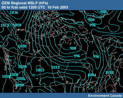
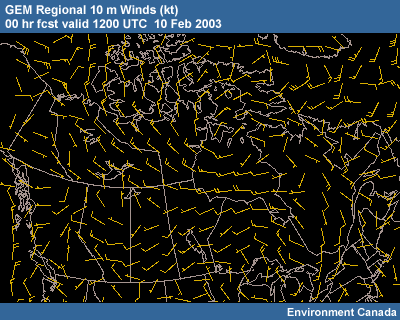
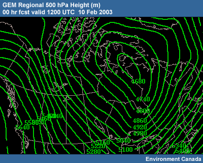
A Lull Before the Next Round
Between 0000 and 1200 UTC on 10 Feb, the winds start letting up. Most stations are no longer reporting blizzard conditions, though winds are still above 15 knots in Baker Lake with periods of blowing snow.
Is it over? Not really. Note the gradient that persists to the northwest through central Nunavut. There is also an embedded wave in this flow. The blowing snow threat in the region won't be over anytime soon.
0000 UTC 10 Feb Content
GEM Regional MSLP (hPa) Content
GEM Regional 10 m Winds (kt) Content
GEM Regional 500 hPa Height (m) Content
GEM Regional 500 hPa Height (m) Content
Surface Observations: Baker Lake (CYBK) Content
CYBK - Baker Lake 71926 BAKER LAKE ARPT & UA NT
CN 64'18N 96'05W 18m
CYBK 100100Z 30019KT 5SM -SN DRSN OVC020 M29/M33 A2948 RMK SC8
SLP986
CYBK 100200Z 31025KT 3SM -SN BLSN SCT020 M31/M35 A2945 RMK
SC3 SLP975
CYBK 100300Z 31023KT 4SM -SN BLSN FEW020 OVC065 M31/M36
A2941 RMK SC2SC6 SLP963
CYBK 100400Z 31015KT 4SM -SN BLSN SCT020
M31/M35 A2939 RMK SC3 SLP955
CYBK 100500Z 31024KT 3SM -SN BLSN
BKN020 M30/M35 A2934 RMK SC6 SLP940
CYBK 100600Z 32023KT 3SM -SN
BLSN OVC020 M29/M33 A2933 RMK SC7 SLP936
CYBK 100618Z 32024KT 1/2SM
-SN BLSN OVC020 RMK BLSN2SC6
CYBK 100700Z 33018KT 2SM -SN BLSN
BKN020 M30/M34 A2932 REBLSN RMK SC5 SLP932
CYBK 100800Z 32014KT 5SM
-SN BLSN BKN020 M30/M35 A2931 RMK SC5 SLP928
CYBK 100900Z 32015KT
5SM -SN DRSN BKN020 M30/M35 A2930 RMK SC5 SLP924
CYBK 101000Z
34016KT 4SM -SN DRSN SCT020 M29/M34 A2929 RMK SC4 SLP921
CYBK
101100Z 35012KT 10SM -SN DRSN SCT020 M30/M35 A2929 RMK SC4 SLP922
CYBK 101200Z 33016KT 4SM -SN DRSN BKN020 M30/M35 A2929 RMK SC5 SNW
CVR/TRACE LOOSE SLP922
1200 UTC 10 Feb Content
GEM Regional MSLP (hPa) Content
GEM Regional 10 m Winds (kt) Content
GEM Regional 500 hPa Height (m) Content
GEM Regional 500 hPa Height (m) Content
Surface Observations: Baker Lake (CYBK) Content
CYBK - Baker Lake 71926 BAKER LAKE ARPT & UA NT
CN 64'18N 96'05W 18m
CYBK 100100Z 30019KT 5SM -SN DRSN OVC020 M29/M33 A2948 RMK SC8
SLP986
CYBK 100200Z 31025KT 3SM -SN BLSN SCT020 M31/M35 A2945 RMK
SC3 SLP975
CYBK 100300Z 31023KT 4SM -SN BLSN FEW020 OVC065 M31/M36
A2941 RMK SC2SC6 SLP963
CYBK 100400Z 31015KT 4SM -SN BLSN SCT020
M31/M35 A2939 RMK SC3 SLP955
CYBK 100500Z 31024KT 3SM -SN BLSN
BKN020 M30/M35 A2934 RMK SC6 SLP940
CYBK 100600Z 32023KT 3SM -SN
BLSN OVC020 M29/M33 A2933 RMK SC7 SLP936
CYBK 100618Z 32024KT 1/2SM
-SN BLSN OVC020 RMK BLSN2SC6
CYBK 100700Z 33018KT 2SM -SN BLSN
BKN020 M30/M34 A2932 REBLSN RMK SC5 SLP932
CYBK 100800Z 32014KT 5SM
-SN BLSN BKN020 M30/M35 A2931 RMK SC5 SLP928
CYBK 100900Z 32015KT
5SM -SN DRSN BKN020 M30/M35 A2930 RMK SC5 SLP924
CYBK 101000Z
34016KT 4SM -SN DRSN SCT020 M29/M34 A2929 RMK SC4 SLP921
CYBK
101100Z 35012KT 10SM -SN DRSN SCT020 M30/M35 A2929 RMK SC4 SLP922
CYBK 101200Z 33016KT 4SM -SN DRSN BKN020 M30/M35 A2929 RMK SC5 SNW
CVR/TRACE LOOSE SLP922
Summary
This is the end of the "Blowing Snow: Baker Lake Case Exercise." This case exercise revisited an extended blowing snow event in northern Canada.
The Case Setting presented the climatology of the region of interest and provided various blowing snow and blizzard condition thresholds.
The Case Exercise addressed the synoptic patterns and existing snow conditions leading up to the event. It tracked the synoptics and low-level wind conditions as the event evolved through the use of model analysis, observations and satellite data. Forecast questions focused on:
- identifying the synoptic pattern that led to blowing snow conditions
- the timing of the passing of an arctic front across the area of interest
- forecasting surface winds and blowing snow conditions at varous time points after frontal passage
- the use of satellite feature identification for verification of blowing snow conditions
- forecasting the persistence of a large-scale pressure gradient
Would you like to take a quiz testing your knowledge of this case exercise?
We are always looking to improve our modules and depend on users for feedback. Please consider filling out a User Survey.
Contributors
COMET Sponsors
The COMET® Program is sponsored by NOAA National Weather Service (NWS), with additional funding by:
- Air Force Weather Agency (AFWA)
- Meteorological Service of Canada (MSC)
- National Environmental Satellite Data and Information Service (NESDIS)
- Naval Meteorology and Oceanography Command (NMOC)
- National Oceanic and Atmospheric Administration (NOAA)
- National Polar-orbiting Operational Environmental Satellite System (NPOESS)
- National Weather Service (NWS)
Project Contributors
Principal Science Advisors
- Patrick Dills — UCAR/COMET
- Ron Goodson — MSC
- Ed Hudson — MSC
- Garry Toth — MSC
- Doug Wesley — UCAR/COMET
Project Lead/Instructional Design
- Bruce Muller — UCAR/COMET
Multimedia Authoring
- Bruce Muller — UCAR/COMET
- Dan Riter — UCAR/COMET
Audio Editing/Productionn
- Seth Lamos — UCAR/COMET
Audio Narration
- Matt Kelsch — UCAR/COMET
Computer Graphics/Interface Design
- Heidi Godsil — UCAR/COMET
Software Testing/Quality Assurance
- Linda Korsgaard — UCAR/COMET
- Michael Smith — UCAR/COMET
Copyright Administration
- Lorrie Fyffe — UCAR/COMET
Data Provided by
- MSC
- NASA
- NWS — NOAA
COMET HTML Integration Team 2021
- Tim Alberta — Project Manager
- Dolores Kiessling — Project Lead
- Steve Deyo — Graphic Artist
- Ariana Kiessling — Web Developer
- Gary Pacheco — Lead Web Developer
- David Russi — Translations
- Tyler Winstead — Web Developer
COMET Staff, December 2004
Director
- Dr. Timothy Spangler
Deputy Director
- Dr. Joe Lamos
Meteorologist Resources Group Head
- Dr. Greg Byrd
Business Manager/Supervisor of Administration
- Elizabeth Lessard
Administration
- Lorrie Fyffe
- Heather Hollingsworth
- Bonnie Slagel
Graphics/Media Production
- Steve Deyo
- Heidi Godsil
- Seth Lamos
- Dan Riter
Hardware/Software Support and Programming
- Tim Alberta (Supervisor)
- James Hamm
- Karl Hanzel
- Ken Kim
- Mark Mulholland
- Carl Whitehurst
Instructional Design
- Patrick Parrish (Supervisor)
- Dr. Alan Bol
- Lon Goldstein
- Dr. Vickie Johnson
- Bruce Muller
- Katherine Olson
- Dwight Owens
- Dr. Sherwood Wang
Meteorologists
- Dr. William Bua
- Patrick Dills
- Tom Dulong
- Kevin Fuell
- Dr. Stephen Jascourt
- Matthew Kelsch
- Dolores Kiessling
- Wendy Schreiber-Abshire
- Dr. Doug Wesley
Software Testing/Quality Assurance
- Michael Smith (Coordinator)
National Weather Service COMET Branch
- Anthony Mostek (NWS COMET Branch Chief [acting] and Satellite Training Leader)
- Brian Motta
- Dr. Robert Rozumalski (SOO Science and Training Resource [SOO/STRC] Coordinator)
- Shannon White (IFPS Training)
Meteorological Service of Canada Visiting Meteorologists
- Peter Lewis
- Garry Toth