Supporting Topics
Reference Maps
Forecasting References
Satellite Detection of Blowing Snow
- Application of Multi-Spectral Satellite Imagery
Reference Maps
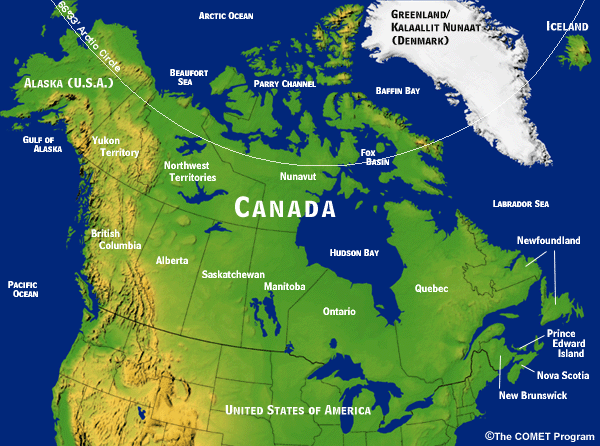
- Canada: Geopolitical Map
-
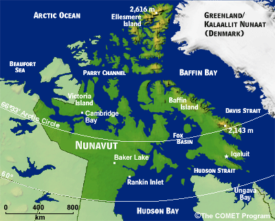
- Nunavut: Relief Map
-
- Baker Lake: Relief Map
-

Forecasting References
- Thresholds for Blowing Snow and Blizzard Conditions
-
Thresholds *Drifting snow - snow on the move at a height less than 2 m. **Blowing snow - horizontal visibility is restricted to 10 km or less because snow particles are raised by the wind to a height of > 2 m Drifting Snow* Blowing Snow** Blizzard Meteorological Service of Canada (MSC) Winds: < 35 km/h (19 kt) Winds: 35-39 km/h (19-21 kt) Winds: >= 40 km/h (22 kt)
Visibility: < 1 km
Temps: <= -10°CMSC Arctic Weather Centre Winds: > 40 km/h (22 kt)
Visibility: < 1 km
Temps: <= 0°C or less
Duration: >= 6 hoursMSC Prairie Storm Centre Winds: > 40 km/h (22 kt)
Visibility: < 1 km
Temps: <= -25°C or less windchill
Duration: >= 4 hoursU.S. National Weather Service not defined not defined Winds: > 56 km/h (30 kt)
Visibility: < 0.4 km
Temps: not defined
Duration: >= 3 hours
Satellite Detection of Blowing Snow
Application of Multi-Spectral Satellite Imagery
- Satellite Detection of Blowing Snow
-
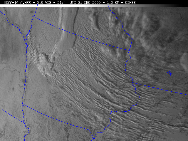
Detection of blowing snow by satellite and in situ observations becomes important for issuing watches and warnings. Blowing snow episodes often start with high winds and relatively clear skies. Under those initial conditions, landmarks such as rivers and lakes are often well defined as dark areas, surrounded by white snow. Where clouds are present, it is often difficult to distinguish between cloud and snow. With visible graphics, animation will show cloud motion. However with blowing snow, how does one know that the observed features are bands of clouds or blowing snow? In those cases, multi-spectral graphics are needed to provide that distinction.
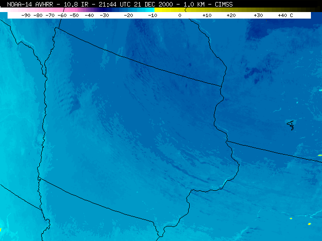
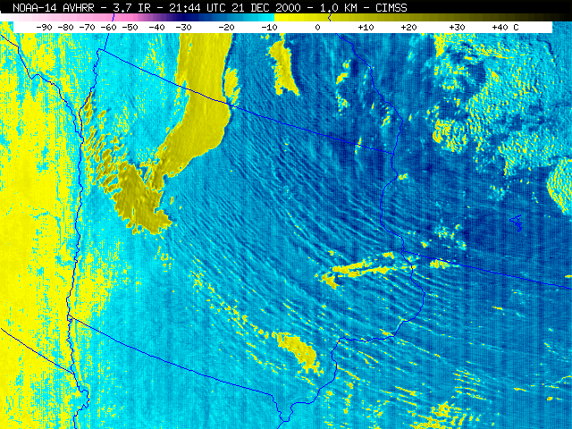
A blowing snow episode over Iowa is captured by visible, shortwave IR, and longwave IR imagery. The visible image shows shadows cast by lines of snow or low-level clouds. In the longwave IR image, the bands are somewhat obscured, however, the image shows colder features to the north and west. The shortwave IR (3.7 micrometer) is more useful for identifying clouds, which are a mixture of water droplets and ice crystals warmer than -10ºC (yellow enhancement - reflecting sunlight) and blowing snow, which is composed of ice crystals and has poorer reflectivity (blue enhancement).
VIS Content
11 μm IR Content
3.7 μm IR Content
- High Resolution EOS-Terra and -Aqua MODIS Imagery
-
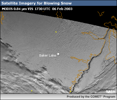
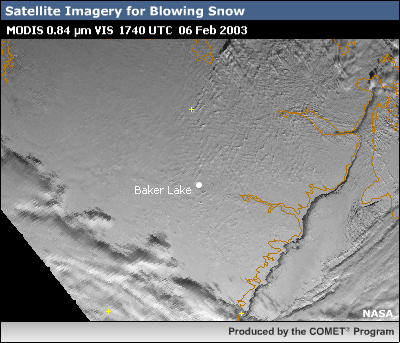
Using satellite imagery to monitor blowing snow events is a difficult task. Conventional visible, shortwave (e.g. 3.9 micrometer) and longwave infrared satellite imagery are fairly adept at detecting clouds and surface features, but do poorly with blowing snow. In the visible, there is little if any brightness contrast between the relatively diffuse patterns of blowing snow and underlying snow and ice to help distinguish between the two. In some cases however, the blowing snow may organize into distinct street-like patterns whose shadows may be seen in high resolution (1km or better) imagery. Image animation can offer additional help for these cases. Most of the blowing snow in the visible imagery shown here however, did not organize into obvious distinct structures.
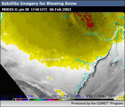
- Longwave Infrared: 11 micrometers
-
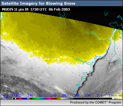
In the longwave infrared (e.g. 11 micrometer), since blowing snow is typically confined to low levels, there is little thermal contrast between the suspended ice crystals and already cold surface below to help separate out any patterns associated with blowing snow.
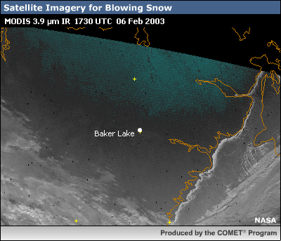
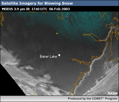
- Shortwave Infrared: 3.7-3.9 micrometers
-
The shortwave infrared region between 3.7 and 3.9 micrometers, commonly used for discriminating cloud phase and low level stratus, also has its problems when trying to isolate blowing snow. At nighttime, snow and ice whether suspended or on the ground, all have similar thermal emission properties and appear relatively indistinguishable. During the daytime, the same snow and ice reflect similar amounts of solar energy making blowing snow again difficult to isolate from a snow and ice covered surface. Similar to the visible imagery, if the blowing snow does organize into distinct street-like patterns, shadows cast by those patterns may become apparent in the imagery. This was unfortunately not the case for this blowing snow event.
- Shortwave Infrared: 1.6-2.1 micrometers
-
Imagery within the 1.6-2.1 micrometer shortwave infrared region offers the best hope in the detection of blowing snow. Note that since most of the energy in this spectral region is reflected solar, the application is for daytime detection only.
Clouds and suspended particles generally reflect more incoming solar at 1.6/2.1 micrometers than features on the ground, particularly for those surfaces covered by snow and ice. This makes 1.6/2.1 micrometer imagery a popular tool for the detection of clouds and especially thin low level stratus which are so common at higher latitudes.
The high-resolution 2.1 micrometer image shown here is from the polar orbiting Terra-MODIS imager. The 2.1 micrometer image was selected over the 1.6 micrometers since 2.1 tends to be even more sensitive to differences between suspended particles and the underlying surface.
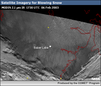
Low level clouds associated with the passing frontal band are readily apparent in lower portions of the image, south of Baker Lake. Compare this image to the visible and notice now the appearance of lighter more diffuse looking banded and blob-like structures. And to the north of Baker Lake we even see with more clarity now some transverse wave-like cloud features that are likely associated with the strong inversion atop the advancing arctic air mass.
Since it is unlikely that we have blowing dust or smoke at this time of year, the diffuse features noted are most likely associated with blowing snow. Animation can help confirm this as we would expect these areas to be moving along with the strong northwesterly surface flow.
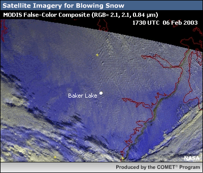
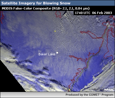
If we look at a short animation of MODIS imagery from Terra and Aqua between 17:30 and 19:15 UTC, we indeed see these suspected pockets of blowing snow moving southeastward.